Research on genetic types and flow system characteristics of wetland in karst fault basin, China
-
摘要:
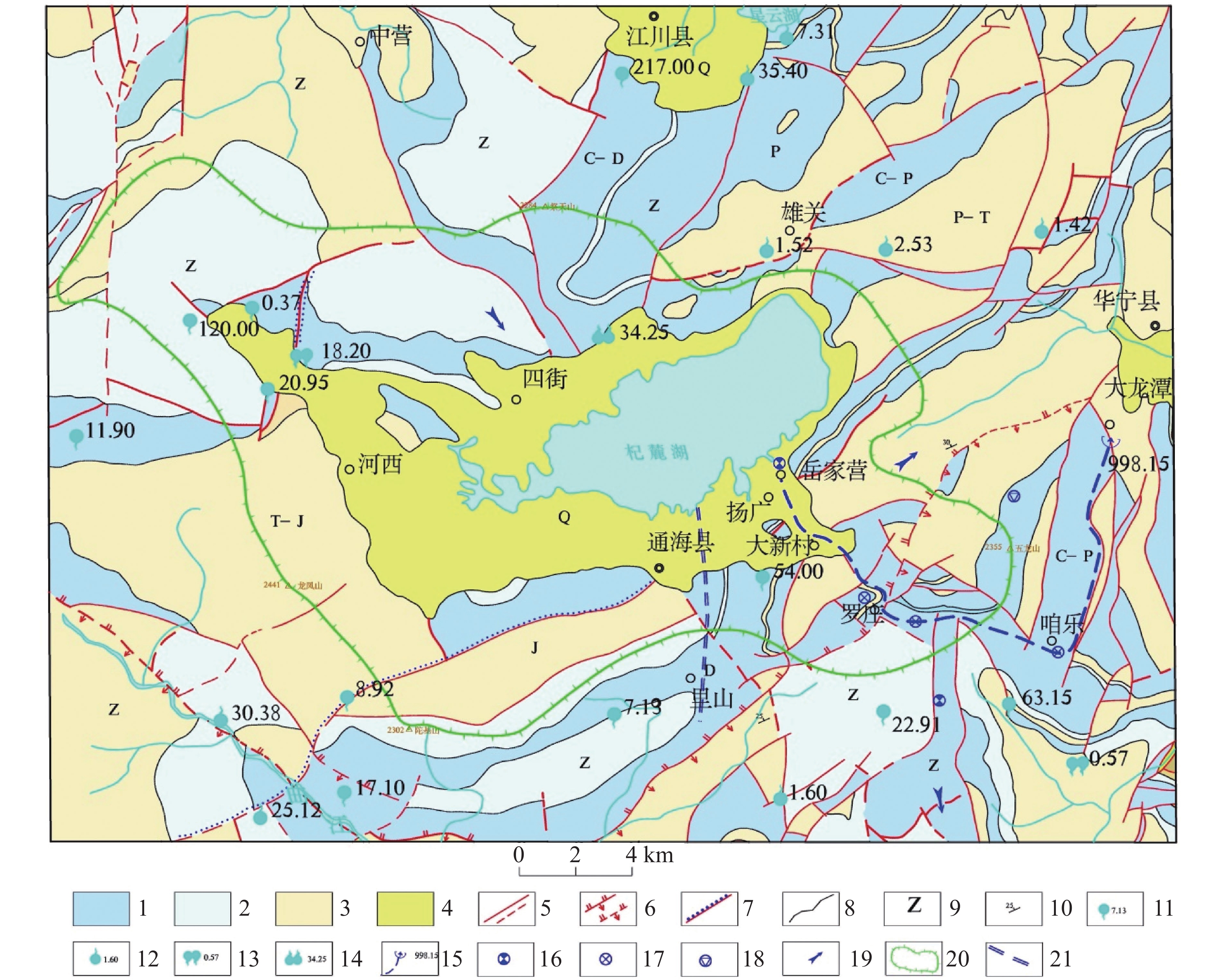
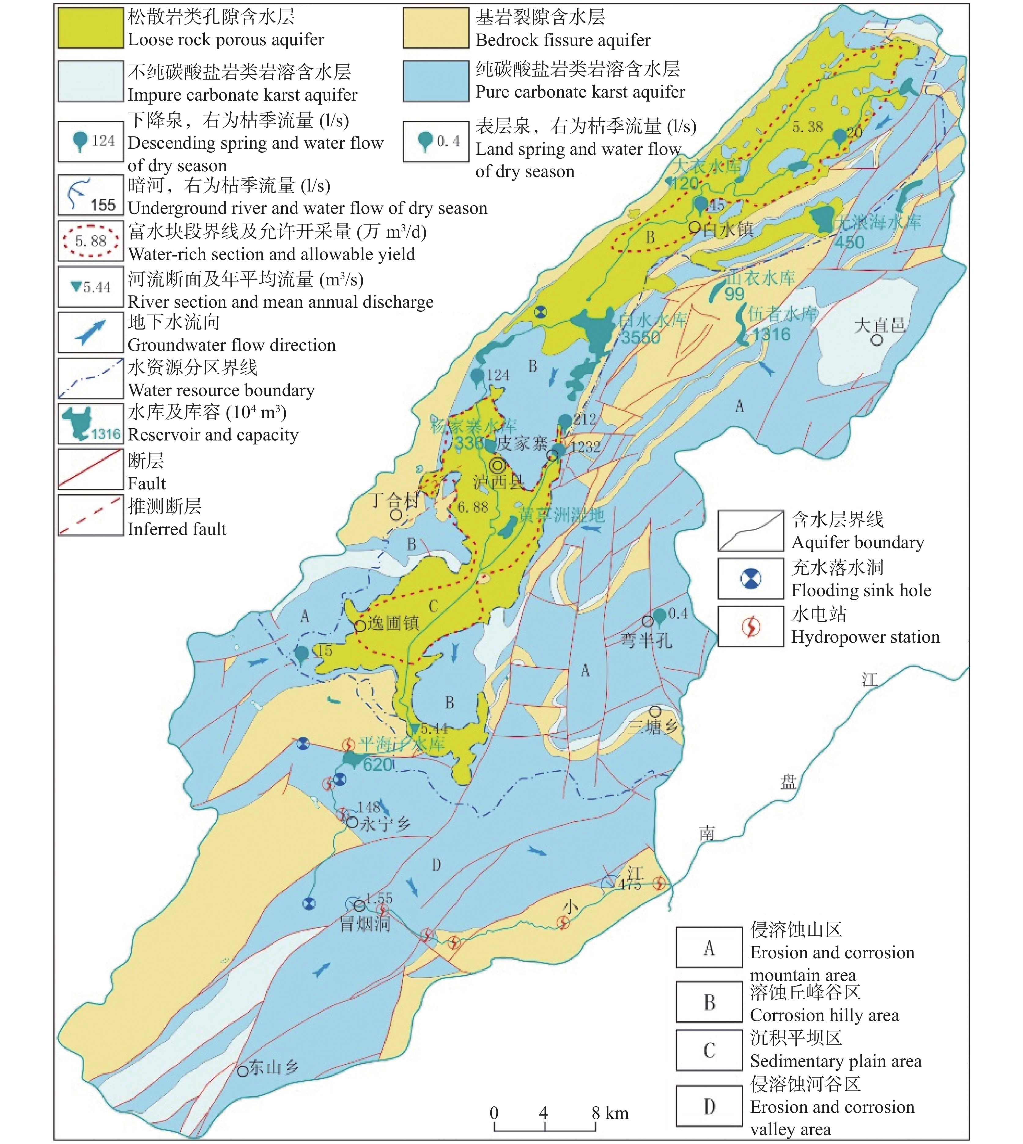
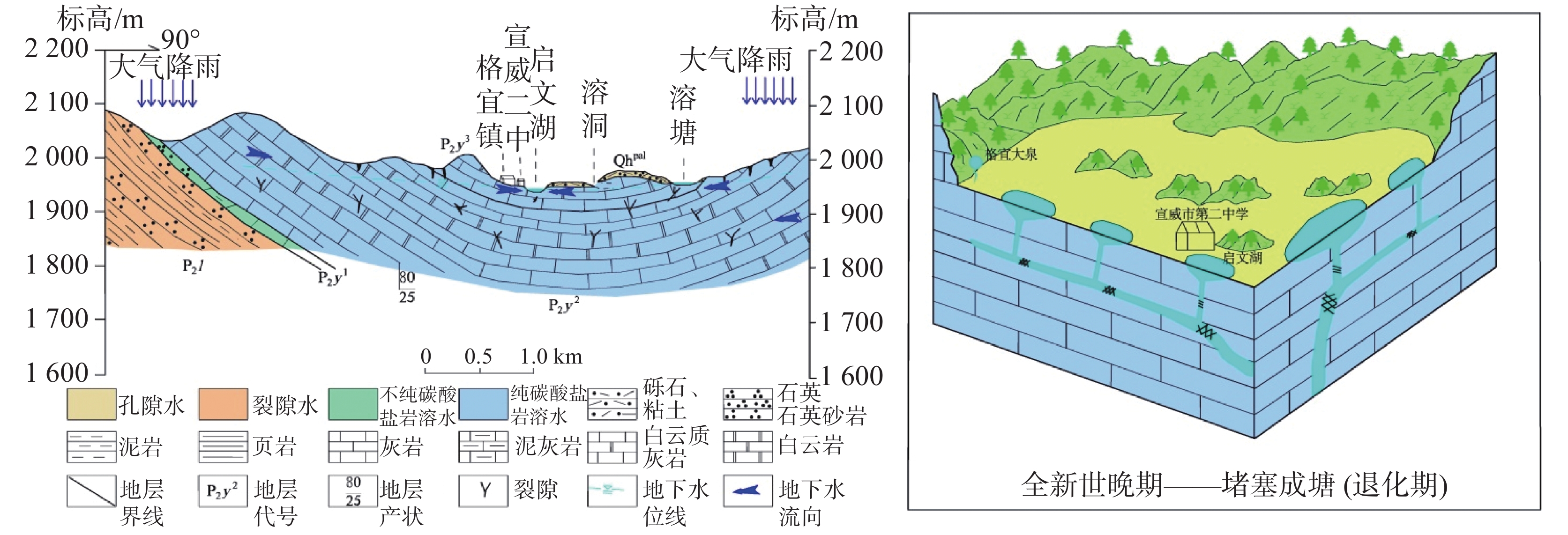
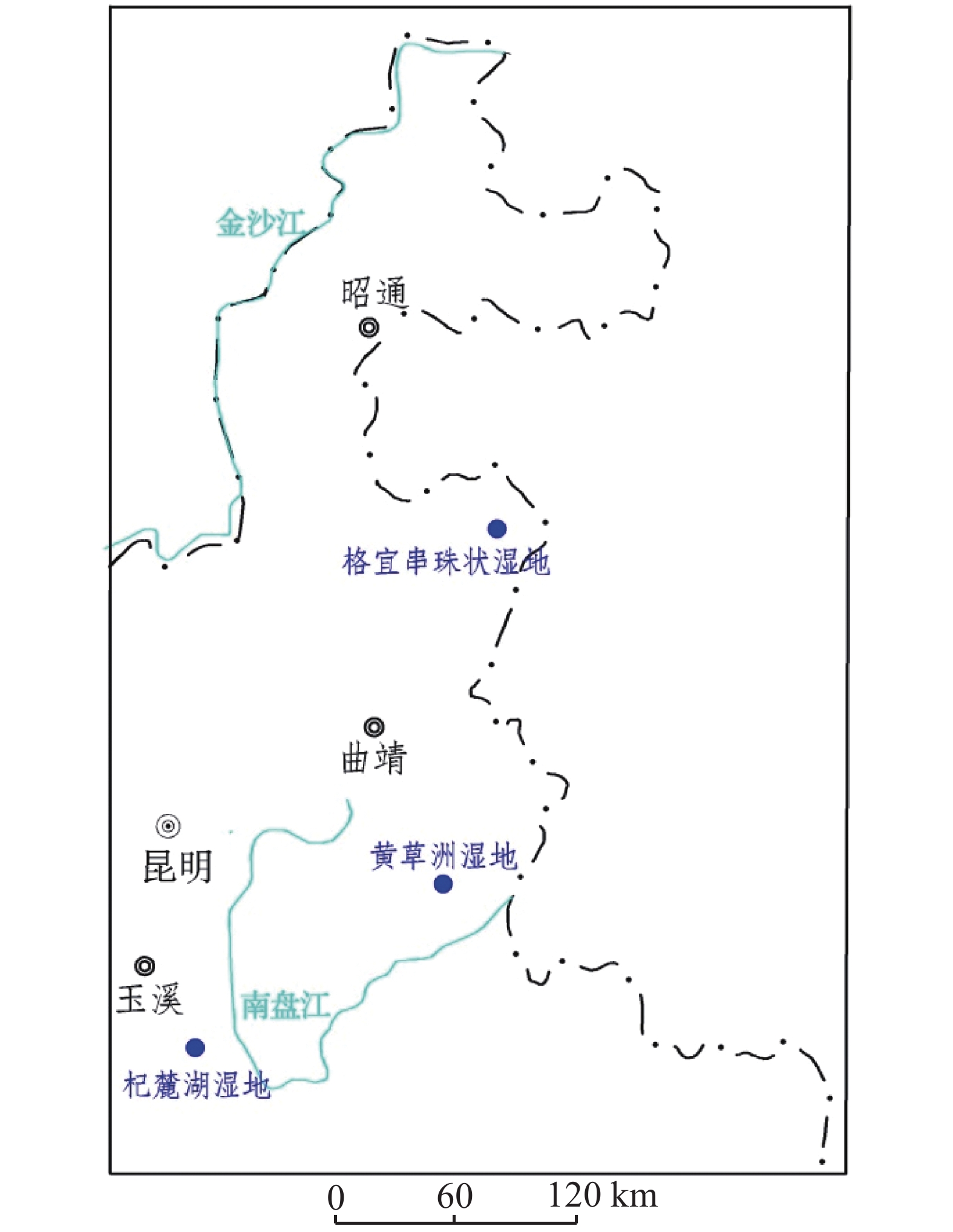
云南断陷盆地岩溶湿地众多,是云南高原生态系统的重要组成部分,但因各种原因,造成湖泊淤积、水面面积缩小以至消亡,滇东地区的湖泊退化较为明显,近30年内有20多个天然湖泊过早消亡。文章开展滇东岩溶断陷盆地内具有代表性的通海湖泊退化型(杞麓湖湿地)、泸西地下水聚积型(黄草州湿地)、宣威地下河淤塞型(格宜串珠状湿地)三种类型典型岩溶湿地研究,主要研究湿地的成因类型及特征、湿地“三场”(径流场、水化学场、温度场)特征,分析岩溶断陷盆地内天然形成的湿地地质条件、水文地质条件、水环境影响因素及定量评价水环境质,以及岩溶湿地自然及人为影响因素、影响形式、作用强度、效应和水源减小、污染加剧、水质下降、湿地萎缩等及其生态环境问题。研究结果表明,通海湖泊退化型(杞麓湖湿地)受人为和自然因素影响较大,水质水量是其退化的主要原因;泸西地下水聚积型(黄草州湿地)受湿地内地下补给、净化、修复,水质总体较好;宣威地下河淤塞型(格宜串珠状湿地)受区域地下水水位变化影响,地下水总体丰富。文章研究成果为岩溶断陷盆地湿地的保护、科学研究、利用、生态修复提供地质依据。
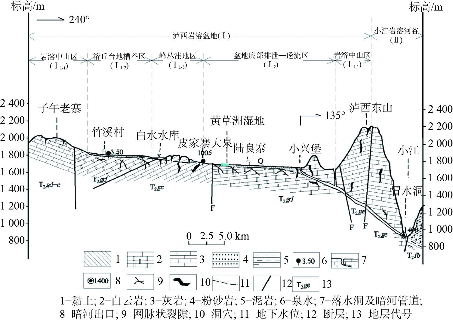
Abstract:As an important part of the ecosystem of Yunnan Plateau, karst wetlands are widely distributed in Yunnan fault basin. However, due to various reasons, lakes are silted up; the water surface area shrinks and even disappears. Lakes in eastern Yunnan are degraded significantly, and more than 20 natural lakes have prematurely disappeared in the past 30 years. In this paper, three typical types of karst wetland in the karst fault basins in eastern Yunnan are studied. These types are Tonghai lake degradation type (Qiluhu wetland), Luxi groundwater accumulation type (Huangcaozhou wetland) and Xuanwei underground river silting type (Geyi beaded wetland). Tonghai Qiluhu karst depression basin is located in the central part of Yunnan Province. It is a karst depression basin developed in the front arc of Yunnan mountain structure. The basin is a closed lake basin with a bottom length of about 22 km, a width of 9 km and a catchwater area of 345.95 km2. The drainage basin of Luxi karst fault basin is located in the marginal slope area of southeast Yunnan Plateau, covering an area of 1,009.28 km2. The bottom of the basin is distributed to the northeast in an irregular oval shape, with a longitudinal length of 16-20 km and a transverse width of 4-5 km. The overall terrain is high in the east and low in the west, and high in the north and low in the south. Xuanwei Geyi karst fault basin belongs to Beipanjiang third-level basin, Gexianghe fourth-level basin, and fifth-level Tianbian underground river system. The whole Tianbian underground river system is divided into a four-level discharge datum. One is Geyi Dalongtan on the edge of Rongqiu Depression, and the other is the beaded lake in Rongqiu Depression around Geyi town. The third is the bottom discharge of the Wujia family depression, and the fourth is the final discharge of the Gexiang river, with a watershed area of 160.82 km2. The research contents include the genetic types and characteristics of wetlands, and the characteristics of "three fields" (runoff field, hydrochemical field and temperature field) of wetlands. The geological conditions, hydrogeological conditions and influencing factors of water environment of naturally formed wetland in karst fault basin are analyzed and the quality of water environment is quantitatively evaluated. The natural and human influencing factors, forms, intensity and effects of karst wetland, water source reduction, pollution intensification, water quality decline, wetland atrophy and ecological environment problems are also analyzed.
The research results indicate that the karst characteristics of the three types of karst fault basin wetlands are relatively similar, with frequent transformation of surface and groundwater, both of which take underground karst pipelines as the medium for transformation channels. Wetlands are discharge areas and also runoff areas that supply the outlet of underground rivers. All of the three types of wetlands are discharged to surface rivers through developed karst pipes. The lake degradation type (Qilu lake) collects surface water lakes at the bottom of the basin from the whole basin; the groundwater accumulation type (Huangcaozhou) is located in the area at shallow water level in the middle of the basin, and pore water and karst water are also recharge sources of wetlands. For the underground river silting type, the karst pipe blockage in the early groundwater runoff channel changes to the present karst fracture runoff, due to the topography of peak-cluster depression. Second, the wetland of lake degradation type (Qilu lake) covers a large area, which is greatly affected by natural and human factors. It is discharged by floods during the rainy season, and is used to irrigate during the dry season. Its severe water pollution is difficult to control with degradation of water quality and quantity. The groundwater accumulation type (Huangcaozhou) is controlled by the groundwater recharge of the upper spring, the underground river and the wetland itself, and the water quality is generally good. Although underground river of the silting type (Geyi beaded wetland) is affected by regional groundwater and human activities, the groundwater is generally abundant and relatively high in quality because the local population is relatively small with little impact. Thirdly, three types of water system structures are studied in terms of the characteristics of supplementation and drainage. The flow system structure of of Qiluhu degraded wetland in Tonghai is, surface collection→karst pipe drainage. The flow system structure of groundwater accumulation wetland in Huangcaozhou of Luxi is: surface runoff+underground seepage→surface runoff→karst pipe discharge. The flow system structure of Xuanweigeyi beaded wetland is, underground fissure seepage→spring drainage→karst pipe drainage.
The study findings suggest that we should protect and utilize wetland resources, and carry out long-term monitoring of wetland quality, water quantity and water level. We should protect wetlands and restore water environment by water transfer and physicochemical and biological measures. We should carry out afforestation and shrub planting around wetland to beautify wetland environment and conserve water source. We should improve farming patterns and use green pesticides. This study will provide a geological basis for the protection, scientific research, utilization and ecological restoration of wetlands in karst fault basins.
-

-
表 1 断陷盆地地质环境特征
Table 1. Characteristics of geological environment of fault basins
岩溶断
陷盆地湿地类型 形态规模 地形地貌 主要含水层 主要构造 岩溶发
育程度湿地规模 通海
盆地杞麓湖湖泊退化型 半月形,呈近东西向,流域面积345.95 km2,盆底面积153.39 km2 盆地四周侵蚀、溶蚀低中山地貌,海拔1 900~2 200 m,坡度20°~30° 二叠系(P)、泥盆系(D)、震旦系(Z)厚层状灰岩、白云岩,多呈块状分布于盆地南部,富水性强 断裂构造为北东及北西向,多为张扭性断层,具有一定的导水富水
作用岩溶发育中等 杞麓湖形似葫芦,东西长15 km,南北宽5 km,湖水面积42.3 km2,占盆地面积的11.95%,最大水深15 m,平均水深4 m,蓄水量约1.94×10⁸ m3 泸西
盆地黄草州地下水聚积型 椭圆形,呈北东向,流域面积,1 009.28 km2,盆底面积78.1 km2 盆地四周侵蚀、溶蚀低中山地貌,海波1 700~2 100 m,坡度20°~45° 三叠系永宁镇组下段(T1ya)、三叠系个旧组 (T2g)、法朗组下段(T2fa)灰岩、白云岩,富水性强 构造以北东和北东东向的断裂和褶皱为主。主要发育雨龙断裂、
白水向斜、杨梅
山背斜岩溶发育强烈 黄草洲湿地目前面积0.26 km2,水平水深1.5 m,最深处可达5 m 宣威格宜洼地 格宜串珠状湿地地下河淤塞型 圆形和不规则型,呈南北向,流域面积160.82 km2 微地貌属溶丘洼地,海拔 1 940~1 950 m,坡度一般小于25° 二叠系阳新组(P2y3)灰岩、白云质灰岩、白云岩、泥质灰岩,富水
性强。格宜向斜构造 岩溶发育强烈 5个溶塘(启文湖、酒厂湖泊、格宜二中湖泊、文渊阁湖泊、崇明湖),呈“⊥”,呈北东—南西向和北西向串珠状分布,面积小于0.01 km2,水深0.6~2.14 m 表 2 湿地水文参数监测表
Table 2. Monitoring table of wetland water parameters
湿地名称 月份 水温/℃ pH 氧化还原/MV 电导率/μ·sm−1 O2/mg·L−1 溶解性总固体/×10−3 水位/m 流量/L·s−1 杞麓湖
湿地3月 18.99 8.87 −113.59 1003.73 8.80 2.15 6月 24.30 8.18 −98.05 1015.54 8.16 675.35 2.46 9月 25.94 8.95 −95.89 911.67 8.83 1.55 12月 15.26 8.90 −108.98 679.28 9.39 577.91 1.25 黄草洲
湿地3月 18.82 7.94 −56.00 420.83 6.36 0.97 619.35 6月 24.45 7.70 −69.38 405.00 7.55 267.86 1.10 612.77 9月 24.97 8.47 −67.88 395.33 9.32 1.12 619.70 12月 16.37 8.74 −99.49 351.72 10.96 274.48 1.12 626.48 格宜串珠
状湿地3月 18.96 8.45 −83.01 343.71 6.09 6月 21.86 7.87 −79.18 326.01 6.13 227.40 9月 21.33 8.87 −138.24 312.38 7.43 12月 10.91 8.42 −168.25 244.50 9.06 216.85 -
[1] 王宇, 李燕, 谭继中, 张贵, 何绕生. 断陷盆地岩溶水赋存规律[M]. 昆明: 云南科技出版社, 2003: 1-4.
WANG Yu, LI Yan, TAN Jizhong, ZHANG Gui, HE Raosheng. Storage rule of karst water in fault basins[M]. Kunming: Yunnan Science & Technology Publishing House, 2003: 1-2.
[2] 马祖陆, 蔡德所, 蒋忠诚. 岩溶湿地分类系统研究[J]. 广西师范大学学报(自然科学版), 2009, 27(2):101-106.
MA Zulu, CAI Desuo, JIANG Zhongcheng. About karst wet land classification system[J]. Journal of Guangxi Normal University (Natural Science Edition), 2009, 27(2):101-106.
[3] 陈静, 罗明明, 廖春来, 马瑞, 周宏, 邹胜章, 陈植华. 中国岩溶湿地生态水文过程研究进展[J]. 地质科技情报, 2019, 38(6):221-230.
CHEN Jing, LUO Mingming, LIAO Chunlai, MA Rui, ZHOU Hong, ZOU Shengzhang, CHEN Zhihua. Review of eco-hydrological process in karst wetlands of China[J]. Geological Science and Technology Information, 2019, 38(6):221-230.
[4] Kayranli B, Scholz M, Mustafa A, Hedmark A. Carbon storage and fluxes within freshwater wetlands: A critical review[J]. Wetlands, 2010, 30(1):111-124. doi: 10.1007/s13157-009-0003-4
[5] Ghermandi A, van den Bergh J C J M, Brander L M, de Groot H L F, Nunes P A L D. Values of natural human-made wetlands: A meta-analysis[J]. Water Resources Research, 2010, 46(12):137-139.
[6] 李益敏, 李卓卿. 国内外湿地研究进展与展望[J]. 云南地理环境研究, 2013, 25(1):36-43. doi: 10.3969/j.issn.1001-7852.2013.01.007
LI Yimin, LI Zhuoqing. Progress and prospect of research on wetlands at home and abroad[J]. Yunnan Geographic Environment Research, 2013, 25(1):36-43. doi: 10.3969/j.issn.1001-7852.2013.01.007
[7] 栾军伟, 崔丽娟, 宋洪涛, 王义飞. 国外湿地生态系统碳循环研究进展[J]. 湿地科学, 2012, 10(2):235-242. doi: 10.3969/j.issn.1672-5948.2012.02.017
LUAN Junwei, CUI Lijuan, SONG Hongtao, WANG Yifei. Foreign research progress on carbon cycle in wetland ecosystems[J]. Wetland Science, 2012, 10(2):235-242. doi: 10.3969/j.issn.1672-5948.2012.02.017
[8] 李春华, 江莉佳, 曾广. 国外城市湿地研究的现状、问题及前瞻[J]. 中南林业科技大学学报, 2012, 32(12):25-30.
LI Chunhua, JIANG Lijia, ZENG Guang. Achievements, limitation and prospectives: overseas urban wetlands researches[J]. Journal of Central South University of Forestry & Technology, 2012, 32(12):25-30.
[9] 李晖, 蒋忠诚, 马祖陆, 杨奇勇, 罗为群, 尹辉, 王月. 桂林会仙岩溶湿地健康评价与补偿机制研究[J]. 中国水土保持, 2013(1):61-64.
LI Hui, JIANG Zhongcheng, MA Zulu, YANG Qiyong, LUO Weiqun, YIN Hui, WANG Yue. Study on health evaluation and compensation mechanism of Huixian rock dissolved wetland in Guilin[J]. Soil and Water Conservation in China, 2013(1):61-64.
[10] 樊连杰, 邹胜章, 卢海平, 裴建国, 卢丽. 岩溶湿地地下水资源高效开发利用示范[J]. 中国矿业, 2019, 28(Supp.2):494-496.
FAN Lianjie, ZOU Shengzhang, LU Haiping, PEI Jianguo, LU Li. Demonstration of efficient development and utilization of groundwater resources in karst wetland[J]. China Mining Magazine, 2019, 28(Supp.2):494-496.
[11] 毛德华, 夏军. 洞庭湖湿地生态环境问题及形成机制分析[J]. 冰川冻土, 2002, 24(4):444-451.
MAO Dehua, XIA Jun. Ecological and environmental problems and their causing mechanisms in Dongting lake wetland[J]. Journal of Glaciology and Geocryology, 2002, 24(4):444-451.
[12] 汤蕾, 赵冰梅, 许东, 尹德涛. 国外湿地研究进展[J]. 安徽农业科学, 2008,36(1): 299-301.
TANG Lei, ZHAO Bingmei, XU Dong, YIN Detao. Research progress on foreign wetland[J]. Journal of Anhui Agricultural Sciences, 2008,36(1): 299-301.
[13] Luo M M, Chen Z H, Criss R E, Zhou H, Jakada H, Shi T T . Method for calibrating a theoretical model in karst springs: An example for a hydropower station in South China[J]. Hydrological Processes, 2016, 30(25):4815-4825. doi: 10.1002/hyp.10950
[14] 田昆, 陆梅, 常凤来, 莫剑锋, 黎良才, 杨永兴. 云南纳帕海岩溶湿地生态环境变化及驱动机制[J]. 湖泊科学, 2004, 16(1):35-42.
TIAN Kun, LU Mei, CHANG Fenglai, MO Jianfeng, LI Liangcai, YANG Yongxing. The ecological environment degradation and degradation mechanism of Napahai karst wetland in southwestern Yunnan Plateau[J]. Journal of Lake Sciences, 2004, 16(1):35-42.
[15] 肖羽芯, 王妍, 刘云根, 郭玉静, 张紫霞, 刘鹏. 典型岩溶湿地流域生态功能区划研究:以滇东南普者黑流域为例[J]. 华中农业大学学报, 2020, 39(2):47-55.
XIAO Yuxin, WANG Yan, LIU Yungen, GUO Yujing, ZHANG Zixia, LIU Peng. Research on ecological function regionalization of typical karst wetland watershed: Take Puzhehei basin as an example[J]. Journal of Huazhong Agricultural University, 2020, 39(2):47-55.
[16] 张紫霞, 刘鹏, 王妍, 张超, 刘云根, 杨波, 张叶飞. 普者黑岩溶湿地沉积物氮、磷、有机质分布及污染风险评价[J]. 生态环境学报, 2019, 28(9):1835-1842. doi: 10.16258/j.cnki.1674-5906.2019.09.015
ZHANG Zixia, LIU Peng, WANG Yan, ZHANG Chao, LIU Yungen, YANG Bo, ZHANG Yefei. Distribution and pollution risk assessment of nitrogen, phosphorus and organic matter in Puzhehei karst wetland sediments[J]. Ecology and Environmental Sciences, 2019, 28(9):1835-1842. doi: 10.16258/j.cnki.1674-5906.2019.09.015
[17] 袁梦. 哈尼梯田湿地水文特征研究[J]. 绿色科技, 2019(10):16-18, 20.
YUAN Meng. Study on hydrological characteristics of Hani terrace wetland[J]. Journal of Green Science and Technology, 2019(10):16-18, 20.
[18] 张华, 康晓波, 杨文兴. 云南通海县岳家营暗河管道水质评价[J]. 云南地质, 2014, 33(4):588-593. doi: 10.3969/j.issn.1004-1885.2014.04.024
ZHANG Hua, KANG Xiaobo, YANG Wenxing. The assessment of tube water in Yuejiaying buried river in Tonghai, Yunnan[J]. Yunnan Geology, 2014, 33(4):588-593. doi: 10.3969/j.issn.1004-1885.2014.04.024
[19] 康晓波, 王宇, 张华. 杞麓湖泄水暗河淤塞的不良环境效应分析[J]. 水文地质工程地质, 2008, 35(6):121-124.
KANG Xiaobo, WANG Yu, ZHANG Hua. An analysis of bad environmental effects of clogging of the discharging underground river of the Qilu Lake[J]. Hydrogeology & Engineering Geology, 2008, 35(6):121-124.
[20] 王波, 张华, 王宇, 张贵, 张文鋆, 高瑜, 罗为群. 泸西喀斯特断陷盆地地表水与地下水流域边界与水动力性质[J]. 中国岩溶, 2020, 39(3):319-326.
WANG Bo, ZHANG Hua, WANG Yu, ZHANG Gui, ZHANG Wenjun, GAO Yu, LUO Weiqun. Watershed boundaries and hydrodynamic propperties of surface water and groundwater in the Luxi karst fault-depression basin[J]. Carsologica Sinica, 2020, 39(3):319-326.
[21] 王宇. 岩溶高原地下水径流系统垂向分带[J]. 中国岩溶, 2018, 37(1):1-8.
WANG Yu. Vertical zoning of groundwater runoff system in karst plateau[J]. Carsologica Sinica, 2018, 37(1):1-8.
[22] 张华, 康晓莉, 彭淑惠, 黄钊, 高瑜, 黄琴辉, 刘绍华, 刘天伦. 云贵高原典型串珠状岩溶湿地水文地质演化研究[J]. 中国岩溶, 2022, 41(4): 532-541.
ZHANG Hua, KANG Xiaoli, PENG Shuhui, HUANG Zhao, GAO Yu, HUANG Qinhui, LIU Shaohua, LIU Tianlun. Hydrogeological evolution of typical moniliform karst wetland in the Yunnan-Guizhou Plateau[J]. Carsologica Sinica, 2022, 41(4): 532-541.
[23] 张贵, 何绕生, 王波, 张文鋆, 周翠琼. 云南华宁县盘溪大龙潭水文地质特征[J]. 贵州大学学报(自然科学版), 2020, 37(5):40-45.
ZHANG Gui, HE Raosheng, WANG Bo, ZHANG Wenjun, ZHOU Cuiqiong. Hydrogeological characteristics of Dalongtan, Panxi, Huaning county of Yunnan Province[J]. Journal of Guizhou University (Natural Sciences), 2020, 37(5):40-45.
[24] 苏博. 云南泸西黄草洲国家湿地公园湿地生态系统调查与评价[J]. 陕西林业科技, 2018, 46(4):47-53. doi: 10.3969/j.issn.1001-2117.2018.04.009
SU Bo. Investigation and evaluation of wetland ecosystem in Huangcaozhou National Wetland Park in Luxi of Yunnan[J]. Shaanxi Forest Science and Technology, 2018, 46(4):47-53. doi: 10.3969/j.issn.1001-2117.2018.04.009
[25] 张华, 王波, 王宇, 张贵, 何绕生, 代旭升, 康晓波, 蓝芙宁. 云南泸西岩溶断陷盆地水循环系统及水资源循环利用方案[J]. 地球学报, 2021, 42(3):313-323.
ZHANG Hua, WANG Bo, WANG Yu, ZHANG Gui, HE Raosheng, DAI Xusheng, KANG Xiaobo, LAN Funing. The water circulation system and water resources recycling plan of the Luxi karst fault-depression basin in Yunnan[J]. Acta Geoscientia Sinica, 2021, 42(3):313-323.
[26] 程亚平, 蒋亚萍, 姚高峰, 黄月群, 冯莉, 黄骏宇. 桂林会仙湿地生态退化特征研究[J]. 工业安全与环保, 2015, 41(4):73-75.
CHENG Yaping, JIANG Yaping, YAO Gaofeng, HUANG Yuequn, FENG Li, HUANG Junyu. Study on the ecological degradation characteristics of Guilin Huixian wetland[J]. Industrial Safety and Environmental Protection, 2015, 41(4):73-75.
[27] 赵一, 邹胜章, 申豪勇, 周长松, 樊连杰, 朱丹尼, 李军. 会仙湿地岩溶地下水系统水位动态特征与均衡分析[J]. 中国岩溶, 2021, 40(2):325-333.
ZHAO Yi, ZOU Shengzhang, SHEN Haoyong, ZHOU Changsong, FAN Lianjie, ZHU Danni, LI Jun. Dynamic characteristics and equilibrium of water level of the karst groundwater system beneath the Huixian wetland[J]. Carsologica Sinica, 2021, 40(2):325-333.
[28] 吴应科, 莫源富, 邹胜章. 桂林会仙岩溶湿地的生态问题及其保护对策[J]. 中国岩溶, 2006, 25(1):85-88.
WU Yingke, MO Yuanfu, ZOU Shengzhang. Ecologic problem and protection method of karst wetland in Huixian, Guilin[J]. Carsologica Sinica, 2006, 25(1):85-88.
[29] 杜良梅, 张丽, 和丽萍, 陈静. 利用人工湿地处理云南高原湖泊入湖河水的净化效果分析[J]. 环境科学导刊, 2013, 32(6):44-47.
DU Liangmei, ZHANG Li, HE Liping, CHEN Jing. Purification effect of inflows of plateau lakes by constructed wetland in Yunnan[J]. Environmental Science Survey, 2013, 32(6):44-47.
[30] 卢蕾吉, 王兴楠. 杞麓湖流域水环境承载能力分析及综合对策[J]. 环境科学导刊, 2021, 40(4):28-30.
LU Leiji, WANG Xingnan. Analysis of environment carrying capacity and comprehensive countermeasures in the Qilu Lake basin[J]. Environmental Science Survey, 2021, 40(4):28-30.
-


 下载:
下载:
