Lithogeochemical and Chronological Test Dataset of Mesozoic and Cenozoic Porphyry Metallogenic System in the Eastern Section of the Gangdise Metallogenic Belt, Tibet
-
摘要:
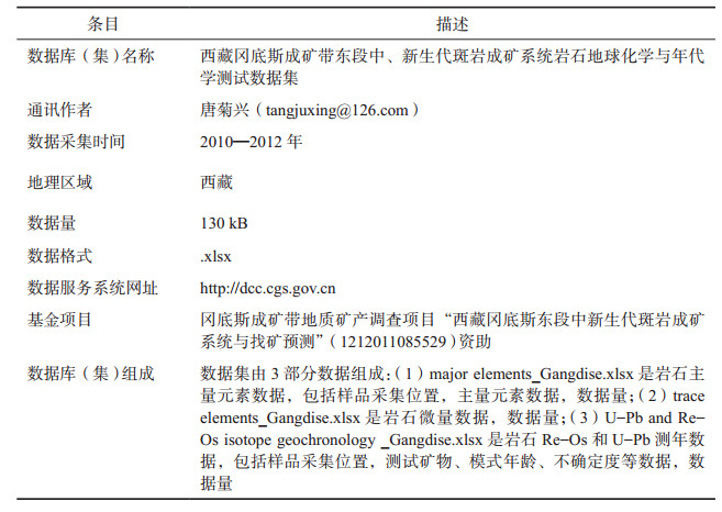
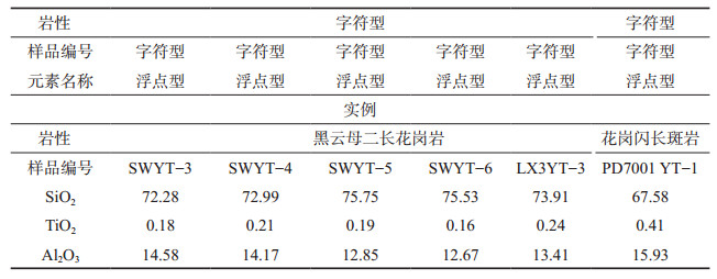
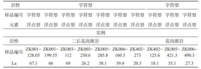
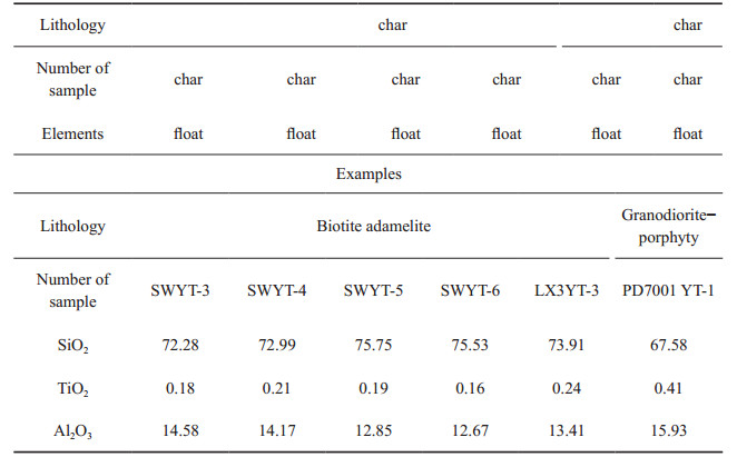
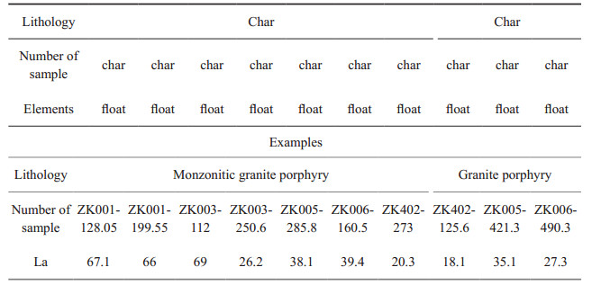
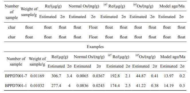
西藏冈底斯成矿带东段中—新生代斑岩成矿系统岩石地球化学测试数据集基于冈底斯成矿带地质矿产调查项目“西藏冈底斯东段中新生代斑岩成矿系统与找矿预测”资助,进行岩石测试分析整理而得。岩石地球化学与地质年代学数据可以全面地反映岩石与矿床成因、成岩与成矿年龄等重要信息,为西藏冈底斯成矿带东段中、新生代斑岩矿床成矿背景与成矿模式研究提供科学依据和基础数据支撑。本数据集为Excel表格型数据,包括3个.xlsx类型文件(majorelement_Gangdise.xlsx,traceelement_Gangdise.xlsx,reos-upb_Gangdise)分别记录主量、微量、测年数据,其中majorelement_Gangdise.xlsx包含141条记录和105个字段,traceelement_Gangdise.xlsx包含273条记录和166个字段,reos-upb_Gangdise包含208条记录和100个字段。其中,主量、微量元素数据涉及与邦铺、达布、程巴、甲玛4个矿床有关的5个岩体。测年数据包括邦铺钼多金属矿床黑云母二长花岗岩等4组锆石U-Pb年龄数据,达布铜(钼)花岗岩体等3组锆石U-Pb年龄数据,甲玛铜多金属矿床5组Re-Os年龄数据,邦铺钼多金属矿床2组Re-Os年龄数据。本库提供全部测试均在国家知名测试数据实验室进行,数据质量可靠。
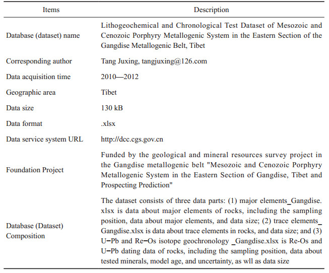
Abstract:The data base for the ore-Cenozoic porphyry metallogenic system in the eastern section of the Gangdise metallogenic belt, Tibet is supported by the Gangdise Metallogenic Belt Geology Mineral Survey Project. Data from petrogeochemistry and geochronology can reflect the genesis of rocks and deposits and the age of diagenesis and mineralization, which will provide a scientific basis and basic knowledge on the metallogenic background and mode of the Mesozoic-Cenozoic porphyry deposit. The data base is conducted in Excel, and includes three.xlsx files recording major, trace and age data:majorelement_Gangdise.xlsx includes 141 records and 105 fields; traceelement_Gangdise.xlsx includes 273 records and 166 fields; U-Pb and Re-Os isotope geochrondogy-Gangdise includes 208 records and 100 fields. The data about major and trace elements involves five rock masses related to Bangpu, Dabu, Chengba, and Jiama deposits. The dating data includes four groups of zircon U-Pb age data of a biotite adamellite in the Bangpu molybdenum polymetallic deposit, three groups of zircon U-Pb age data of a granitic pluton in the Dabu copper-molybdenum deposit, five groups of Re-Os age data in the Jiama copper polymetallic deposit, and two groups of Re-Os age data in the Bangpu molybdenum polymetallic deposit. The data provided by the base were carried out in a well-known national test data laboratory, and thus data quality is reliable.
-
1. 引言
1.1 区域地质背景
研究区大地构造位置处于西藏特提斯构造域拉萨地块东段中南部,拉萨地块夹持于雅鲁藏布江缝合带与班公湖—怒江缝合带之间,又被称作冈底斯—念青唐古拉板块或冈底斯造山带。朱弟成等(2008)根据岩浆岩时空分布与其构造环境特征将冈底斯带由南向北划分为南冈底斯、冈底斯弧背断隆带、中冈底斯和北冈底斯。本文数据采集地主要涉及南冈底斯和冈底斯弧背断隆带。
区域地层主要归属于冈底斯—腾冲区的拉萨—察隅分区、隆格尔—南木林分区、日喀则分区,少部分地层涉及到喜马拉雅区的雅鲁藏布江分区。
区域所属拉萨—察隅分区地层由老至新主要有:新元古界(岩性为片岩、大理岩、石英岩、片麻岩、变粒岩、浅粒岩、透辉岩、斜长角闪岩等),古生界下石炭统诺错组(C1n,岩性为砂质板岩、钙质板岩等)、上石炭—下二叠统来姑组(C2-P1l,岩性为砂岩、砾岩、板岩等)、中二叠统洛巴堆组(P2l,岩性灰岩、大理岩和火山碎屑岩等)、中二叠统蒙拉组(P2m,岩性为变质砂岩、白云岩等),上二叠统列龙沟组(P3l,岩性为砂岩、板岩等),中生界下三叠—中三叠统查曲浦组(T1-2c,岩性为火山角砾岩、安山岩、凝灰岩、英安岩等)、上三叠统麦隆岗组(T3m,岩性为灰岩、页岩、砂岩等)、上三叠—下侏罗统甲拉浦组(T3-J1j,岩性为泥岩、页岩、粉砂岩等)、下侏罗—中侏罗统叶巴组(J1-2y,岩性为玄武岩、火山角砾岩、火山集块岩,安山岩、英安岩、流纹岩、变质砂岩、粉砂岩片岩、板岩等)、上侏罗统却桑温泉组(J3q,岩性为砾岩、砂砾岩、砂岩、粉砂岩、页岩等)、上侏罗统多底沟组(J3d,岩性为灰岩、大理岩等)、下白垩统林布宗组(K1l,岩性为砂岩、板岩、炭质泥岩等)、下白垩统楚木龙组(K1ch,岩性为粉砂岩、石英砂岩等)、下白垩统塔克那组(K1t,岩性为灰岩、碳酸盐岩、砂岩、泥页岩等)、下白垩统麻木下组(K1m,岩性为安山岩、砾岩、粉砂岩等)、下白垩统比马组(K1b,岩性为火山岩、砂岩、泥岩、灰岩、大理岩等)、下白垩统门中组(K1m,岩性为变质细砂岩、砂岩、泥质灰岩、大理岩等)、上白垩统温区组(K2w,岩性为钙泥质板岩、粉砂质板岩、凝灰质板岩等)、上白垩统设兴组(K2ŝ,岩性为砂岩、泥岩等透镜体、砂砾岩、中酸性火山岩等)和上白垩统—古近系旦师庭组(K2-Ed,岩性为安山质火山角砾岩、火山集块岩、角砾熔岩等)。
区域所属隆格尔—南木林分区地层由老至新主要有:前震旦纪念青唐古拉群(岩性为片岩、片麻岩、变粒岩、浅粒岩和大理岩等),古生界下石炭统永珠组(C1y,岩性为变质长石石英砂岩、变质细粒石英砂岩、变质砂岩等)、中石炭统拉嘎组(C2l,岩性为含砾砂岩、含砾板岩)、中石炭统昂杰组(C2a,岩性为粉砂岩、变质砂岩、板岩等)和下二叠统下拉组(P1x,岩性为灰岩、大理岩等),中生界上侏罗统麻木下组(J3m)、上侏罗—下白垩统林布宗组(J3K1l,岩性为含煤细碎屑岩)、下白垩统楚木龙组(K1ĉ,岩性为石英砂岩、粉砂岩、粉砂质泥岩等)、下白垩统塔克那组(K1t,岩性为结晶灰岩、角砾状灰岩等)、下白垩统比马组(K1b)、上白垩统设兴组(K2ŝ,岩性为砂岩、泥岩、页岩等),新生界古新统主要包括典中组(E1d)、年波组(E2n)、帕那组(E2p)、日贡拉组(E3r,岩性为陆缘碎屑沉积岩)、芒乡组(N1m,岩性为含煤碎屑岩夹火山岩)、嘎扎村组(N2g,岩性为火山岩夹碎屑岩组合)、宗当村组(N2z)、旦师庭组(Ed,岩性为中酸性火山熔岩及火山碎屑岩)、秋乌组(E2q,岩性为含煤碎屑岩)和大竹卡组(E3N1d)以及第四系(Q)。
日喀则分区主要地层为下白垩统冲堆组(K1cd,岩性为长石砂岩、粉砂质页岩夹灰岩、硅质岩)和上白垩统昂仁组(K2a,复理石)。
冈底斯东段区域构造包括断裂、韧性剪切带及褶皱。
断裂以雅鲁藏布江复合断裂带、米拉山断裂带、嘉黎断裂带为主。雅鲁藏布江复合断裂带总体沿雅鲁藏布江展布,东段长度大于190 km,最宽部位约9 km,是印度与欧亚板块的分界线,亦为拉萨地块与喜马拉雅地块分界线(袁万明等,2002)。米拉山断裂带:沙莫勒—麦拉—洛巴堆—米拉山断裂在冈底斯东段发育的一部分(图 1),该断裂是拉萨地块南冈底斯与冈底斯弧背断隆带之分界(朱弟成等,2008)。嘉黎断裂带:狮泉河—拉果错—永珠—纳木错—嘉黎混杂岩带在冈底斯东段的重要组成部分(图 1),该断裂是拉萨地块冈底斯弧背断隆带与北冈底斯之界线(任金卫等,2000)。
韧性剪切带以冈底斯岩基中段南缘韧性剪切带、扎雪—门巴韧性剪切带、色日绒—巴嘎脆韧性变形带、谢通门—努玛脆韧性—韧性剪切带为主。冈底斯岩基中段南缘韧性剪切带位于雅鲁藏布江缝合带北侧,该带由两条近于平行的近东西向展布的剪切带组成,倾向北,倾角为30°~60°,长度超过120 km,宽度为1~8 km,剪切带整体具正剪切带特征。扎雪—门巴韧性剪切带是拉多岗—日阿—领布冲韧性剪切带东段的延续,沿却日啊、扎雪南、舍嘠松多北、门巴北近东西向舒缓波状产出,长逾80 km,出露宽度为0.5~2.5 km,剪切带整体向北倾斜,倾角变化范围为70°~75°(张认等,2007),剪切带性质为北向南逆冲推覆兼具左行走滑的斜冲韧性剪切带(翟文建等,2012)。色日绒—巴嘎脆韧性变形带沿色日绒、绒多、措麦、巴嘎一线近东西向发育,面理总体倾向北,沿走向断续延伸超过100 km。谢通门—努玛脆韧性—韧性剪切带西起谢通门县通门乡,向东至努玛乡,长大于200 km,宽度不一。
褶皱构造的发育多与区域性逆冲推覆构造相关,与区域性断层或韧性剪切带相伴产出,如雅鲁藏布江复合断裂带附近的达孜—普龙岗复式褶皱隆起带、昌果复式背斜褶皱带等,旁多逆冲推覆构造系统中央日阿卡背斜、哈母向斜等(叶培盛,2004);与色日绒—巴嘎韧性剪切带相关的色日绒—巴嘎复式背斜、桑巴背斜、爬多拉向斜褶皱等(杨德明等,2004)。
区域岩浆侵入主要发生于侏罗纪、早白垩世、晚白垩世、古新世—始新世和中新世;冈底斯东段二叠纪岩浆活动相对较弱,岩浆岩不甚发育;三叠纪岩浆岩分布局限,侵位时代多属于晚三叠世。区域火山喷发活动主要发生于早—中侏罗世、早白垩世、晚白垩世—始新世;另外,石炭纪—二叠纪火山岩在在冈底斯弧背断隆带上亦有所发育。
区域矿产资源主要有铜、铅、锌、金、银、钼、铁、钨、锡、铋、钴等,此外还发育有盐类、铀等非金属矿产和能源矿产(图 2)。其中,铜、铅锌、金等优势矿种具有储量大、品位高、开采条件佳等特点,目前冈底斯成矿带业已成为国家重要的资源接续基地。
图 2. 冈底斯成矿带矿产分布图1—矿床(点);2—第四系;3—新生代;4—中生代;5—古生代;6—前震旦系;7—喜山期花岗岩;8—燕山期花岗岩;9—超基性岩;10—结合带;a—吉如铜矿;b—白容铜矿;c—总训铜矿;d—冲江铜矿;e—厅宫铜矿;f—达布铜钼矿;g—拉抗俄铜矿;h—驱龙铜(钼)矿;i—知不拉铜多金属矿;j—甲玛铜多金属矿;k—向背山铜矿;l—勒青拉铅锌矿;m—邦铺钼(铜)矿;n—克鲁铜矿;o—冲木达铜矿;p—夏马日铜矿;q—吹败子铜矿;r—程巴钼铜钨矿;s—努日铜钼钨矿;t—亚贵拉铅锌多金属矿;u—沙让钼矿; v—汤不拉钼(铜)矿w—蒙亚啊铅锌矿;x—拉屋铅锌铜矿;y—列廷冈铁铜钼金矿1.2 数据意义
冈底斯成矿带东段是整个青藏高原矿产资源最为丰富的地段之一,自南部雅鲁藏布江缝合带向北至冈底斯弧背断隆带分别发育铜金钼钨成矿南亚带,包括雄村铜金矿、克鲁铜金矿、冲木达金矿、程巴钼铜矿、努日铜钨钼矿等;铜钼成矿中亚带,包括朱诺铜矿、厅宫铜矿、驱龙铜钼矿、甲玛铜多金属矿、邦铺钼多金属矿等;铅锌钼银多金属成矿北亚带,包括沙让钼矿、亚贵拉铅锌钼多金属矿、洞中拉—洞中松多铅锌多金属矿等。冈底斯成矿带东段囊括了中生代雅鲁藏布江新特提斯洋向北俯冲至新生代印—亚大陆碰撞过程中伸展阶段所形成的众多斑岩成矿系统。西藏冈底斯东段中、新生代斑岩成矿系统岩石地球化学测试数据集以冈底斯东段多个金属矿床为研究对象,采用岩石地球化学测试方法,提取岩石主量元素、微量元素和成矿年龄数据,对探究冈底斯东段岩浆岩石类型、成岩成矿时代、矿床成因机理以及成岩成矿构造动力学背景均具有重要价值。
1.3 数据集元数据简介
西藏冈底斯东段中、新生代斑岩成矿系统岩石地球化学测试数据集的元数据简表见表 1。本数据集为Excel表格型数据,包括3个.xlsx类型文件(majorelement_Gangdise. xlsx,traceelement_Gangdise.xlsx,reos-upb_Gangdise)分别记录主量、微量、测年数据,其中majorelement_Gangdise.xlsx包含141条记录和105个字段,traceelement_Gangdise. xlsx包含273条记录和166个字段,reos-upb_Gangdise包含208条记录和100个字段。其中,主量、微量元素数据涉及与邦铺、达布、程巴、甲玛4个矿床有关的5个岩体。测年数据包括邦铺钼多金属矿床黑云母二长花岗岩等4组锆石U-Pb年龄数据,达布铜(钼)花岗岩体等3组锆石U-Pb年龄数据,甲玛铜多金属矿床5组Re-Os年龄数据,邦铺钼多金属矿床2组Re-Os年龄数据。它包括数据集的名称、数据论文作者、通讯作者、数据采集时间、地理区域、空间分辨率、数据量、数据格式、审图号、数据出版地址、基金项目、数据库(集)组成等。
表 1. 数据库(集)元数据简表2. 数据采集和处理方法
2.1 样品采集
本次研究所采集的岩石样品涉及4个矿床,共计134件。其中,程巴斑岩型钼(铜)矿床矿区采集7件二长花岗岩样品,3件花岗斑岩样品,计10件;邦铺钼多金属矿床矿区采集5件黑云母二长花岗岩样品,1件花岗闪长斑岩样品,4件二长花岗岩样品,4件石英二长斑岩样品,计14件;达布铜钼矿床矿区采集27件花岗闪长岩样品,25件花岗斑岩样品,14件花岗闪长斑岩样品,计66件;甲玛铜多金属矿床矿区采集9件花岗斑岩样品,8件花岗闪长斑岩样品,8件二长花岗斑岩样品,10件闪长玢岩样品,3件云斜煌斑岩样品,6件闪斜煌斑岩样品,计44件。对采集的上述样品进行主量元素和微量元素含量测试分析。
2.2 测试方法
本次研究工作对程巴斑岩型钼(铜)矿床、邦铺钼多金属矿床、达布铜钼矿床、甲玛铜多金属矿床4矿床的岩浆岩样品进行全岩主量和稀土微量元素的地球化学测试和分析,测试工作于国家地质实验测试中心、核工业北京地质研究院分析测试中心和西南冶金测试中心完成。上述样品的常量元素含量测试采用X-射线荧光光谱法(XRF)法。微量元素和稀土元素测试采用ICPMS法。其中,全岩主量元素分析误差优于5%;微量元素测定时,当元素含量大于10×10-6时,误差小于10%。本文年代学测试方法主要为LA-ICP-MS锆石U-Pb同位素法和辉钼矿Re-Os同位素法。前者主要于中国地质科学院矿产资源研究所和西北大学完成,后者则于国家地质实验测试中心完成。
3. 数据样本描述
西藏冈底斯成矿带东段中、新生代斑岩成矿系统岩石地球化学测试数据集为Excel表格型数据,包含3个Excel数据文件,分别为“major element_Gangdise.xlsxi、xtrace element_Gangdise.xlsxi和“U-Pb and Re-Os isotope geochronology_Gangdise.xlsxi。其中“major element_Gangdise.xlsx”数据文件,描述研究区内不同矿床岩石样品主量元素信息(表 2);“trace lement_Gangdise.xlsx”数据文件,描述研究区内不同矿床岩石样品微量、稀土元素信息(表 3);“U-Pb and Re-Os isotope geochronology_Gangdise.xlsx”描述辉钼矿样品Re-Os年龄数据信息和岩浆岩锆石U-Pb年龄数据信息(表 4)。
表 2. 岩石主量元素数据数据表表 3. 岩石微量数据数据表表 4. 岩石Re-Os测年数据表4. 数据质量控制和评估
“U-Pb and Re-Os isotope geochronology_Gangdise.xlsx”中Re、Os含量的不确定度包括样品和稀释剂的称量误差、稀释剂的标定误差、质谱测量的分馏校正误差、待分析样品同位素比值测量误差。置信水平95%。模式年龄的不确定度还包括衰变常数的不确定度(1.02%),置信水平95%。从理论上讲,辉钼矿187Re-187Os等时线初始值为零。但由于实验误差,它可能是一个很小的正值或负值,在误差范围内接近零。由于辉钼矿中不含有普Os,其Re-Os等时线只能给出矿物形成的年龄,而不能提供物质来源的信息。
在计算模式年龄或作187Re-187Os等时线时187Re和187Os的单位应该是摩尔质量浓度。为了直观,实际上采用了质量浓度,即ng/g。这是因为187Re原子量186.955765和187Os原子量186.955762非常接近。无论采用什么单位得到的模式年龄或等时线年龄的差别都将小于千万分之一,远远小于目前年龄测定的不确定度范围2%。
锆石U-Pb测年中,描述同位素比值及年龄的误差为±σ,那么误差部分具体表示什么含义,怎么表达才合理呢?误差是自然存在的,误差自始至终贯穿一切科学实验之中,误差只能减小,不可能完全消除。误差的表示方法有两种,即绝对误差和相对误差。王延兴等(2008)认为,“在表达实验结果时,一般包括3个部分:结果的测量值,结果的误差范围(用绝对误差表示)和结果的准确程度(用相对误差表示)”。绝对误差为测量值(x)与被测量值的真值(x0)的差,公式为△=x0-x;相对误差为绝对误差与被测量值的真值的比值,公式为δ=△/x0×100%。绝对误差和相对误差都有正负号。而σ为标准偏差,其值为大于等于0。
5. 结论
冈底斯成矿带东段是整个青藏高原矿产资源最为丰富的地段之一,西藏冈底斯东段中、新生代斑岩成矿系统岩石地球化学测试数据集对探究冈底斯东段岩浆岩石类型、成岩成矿时代、矿床成因机理以及成岩成矿构造动力学背景具有重要意义。
1. Introduction
1.1 Regional Geological Background
In respect of tectonic structure, the study area is located in the central southern portion of the eastern section of the Lhasa block of the Tethyan tectonic domain in Tibet. The Lhasa block, also called the Gangdise—Nyainqentanglha plate or the Gangdise orogenic belt, is located between the Yarlung Zangbo suture zone and the Bangong-Nujiang suture zone. Zhu et al. (2008) divided the Gangdise belt into the South Gangdise, Gangdise back− arc fault−uplift zone, Middle Gangdise, and North Gangdise in terms of the spatial and temporal distribution of magmatic rocks and the characteristics of tectonic environment. The data acquisition places mainly related to South Gangdise and Gangdise back−arc fault−uplift zones.
The regional strata mainly belong to the Lhasa—Zayu, Lunggar—Namling, and Xigaze subregions of the Gangdise—Tengchong region. A small part of the strata relate to the Yarlung Zangbo subregion of the Himalayan region.
In the Lhasa—Zayu subregion regional strata mainly include the following from old to new: the Neoproterozoic erathem (with lithology including schist, marble, quartzite, gneiss, granulite, leptite, bistagite, and amphibolite, etc.); the Paleozoic Lower Carboniferous Nuoco Formation (C1n, with lithology including sandy slate, and calcareous slate, etc.); Upper Carboniferous─Lower Permian Laigu Formation (C2─P1l, with lithology including sandstone, conglomerate, and slate, etc.); Middle Permian Luobadui Formation (P2l, with lithology including limestone, marble, and volcaniclastic rock, etc.) and Mengla Formation (P2m, with lithology including metasandstone, and dolomite, etc.); Upper Permian Lielonggou Formation (P3l, with lithology including sandstone, and slate, etc.); the Mesozoic Lower─Middle Triassic Chaqupu Formation (T1-2c, with lithology including volcanic breccia, andesite, tuff, and dacite, etc.); Upper Triassic Mailonggang Formation (T3m, with lithology including limestone, shale, and sandstone, etc.); Upper Triassic─Lower Jurassic Jialapu Formation (T3─J1j, with lithology including mudstone, shale, and siltstone, etc.); Lower─Middle Jurassic Yeba Formation (J1-2y, with lithology including basalt, volcanic breccia, volcanic agglomerate, andesite, dacite, rhyolite, metasandstone, siltstone, schist, and slate, etc.); Upper Jurassic Quesangwenquan Formation (J3q, with lithology including conglomerate, glutenite, sandstone, siltstone, and shale, etc.) and Duodigou Formation (J3d, with lithology including limestone, and marble, etc.); Lower Cretaceous Linbuzong Formation (K1l, with lithology including sandstone, slate, and carbonaceous mudstone, etc.), Chumulong Formation (K1ch, with lithology including siltstone, and quartz sandstone, etc.), Takena Formation (K1t, with lithology including limestone, carbonatite, sandstone, and argillaceous shale, etc.), Mamuxia Formation (K1m, with lithology including andesite, conglomerate, and siltstone, etc.), Bima Formation (K1b, with lithology including volcanic rock, sandstone, mudstone, limestone, and marble, etc.) and Menzhong Formation (K1m, with lithology including metamorphic fine sandstone, sandstone, argillaceous limestone, and marble, etc.); Upper Cretaceous Wenqu Formation (K2w, with lithology including calcareous argillaceous slate, silty slate, and tuffaceous slate, etc.), Shexing Formation (K2ŝ, with lithology including sandstone, mudstone and other lenses, glutenite, and intermediate-acidic volcanic rock, etc.); and Upper Cretaceous─Paleogene Danshiting Formation (K2─Ed, with lithology including andesitic volcanic breccia, volcanic agglomerate, and breccia lava, etc.).
The regional strata in the Lunggar—Namling subregion mainly include the following from old to new: the Presinian Nyainqentanglha Group (with lithology including schist, gneiss, granulite, leptite, and marble, etc.); the Paleozoic Lower Carboniferous Yongzhu Formation (C1y, with lithology including metamorphic feldspathic quartz sandstone, metamorphic fne grained quartz sandstone, and metasandstone, etc.); Middle Carboniferous Laka Formation (C2l, with lithology including pebbly sandstone, and pebbly slate) and Angjie Formation (C2a, with lithology including siltstone, metasandstone, and slate, etc.); the Lower Permian Xiala Formation (P1x, with lithology including limestone, and marble, etc.); the Mesozoic Upper Jurassic Mamuxia Formation (J3m); Upper Jurassic─Lower Cretaceous Linbuzong Formation (J3K1l, with lithology including coal− bearing fine grained clastic rock); Lower Cretaceous Chumulong Formation (K1ĉ, with lithology including quartz sandstone, siltstone, and silty mudstone, etc.), Takena Formation (K1t, with lithology including crystalline limestone, and brecciaous limestone, etc.) and Bima Formation (K1b); Upper Cretaceous Shexing Formation (K2ŝ, with lithology including sandstone, mudstone, and shale, etc.); the Cenozoic Paleocene that mainly comprises the Dianzhong Formation (E1d), Nianbo Formation (E2n), Pana Formation (E2p), Rigongla Formation (E3r, with lithology of epicontinental clastic sedimentary rock), Mangxiang Formation (N1m, with lithology of coal−bearing clastic rock sandwiched with volcanic rock), Gazhacun Formation (N2g, with lithology of volcanic rock sandwiched with clastic rock), Zongdangcun Formation (N2z), Danshiting Formation (Ed, with lithology including medium acidic lava and volcaniclastic rock), Qiuwu Formation (E2q, with lithology of coal-bearing clastic rock), and Dagzhuka Formation (E3N1d); as well as the Quaternary (Q).
In the Xigaze subregion strata mainly include the Lower Cretaceous Congdu Formation (K1cd, with lithology including arkose, silty shale sandwiched with limestone, and siliceous rock) and the Upper Cretaceous Ngamring Formation (K2a, with lithology including multiple flysches).
The regional structures in the eastern section of Gangdise include faults, ductile shear zones, and folds.
Faults in the region are dominated by the Yarlung Zangbo compound fault zone, the Mila Mountain fault zone and the Lhari fault zone. The Yarlung Zangbo compound fault zone spreads along the Yarlung Zangbo River as a whole, with the eastern section being longer than 190 km, with the widest part of about 9 km; it is a boundary between the Indian and Eurasian plates and between the Lhasa and Himalayan blocks (Yuan et al., 2002). The Mila Mountain fault zone is a part of the Shamole-Maila-Luobadui-Mila Mountain fault (Fig. 1), developed in the eastern section of Gangdise, and it is a boundary between South Gangdise and Gangdise back-arc fault-uplift zones in the Lhasa block (Zhu et al., 2008a, b). The Lhari fault zone is an important part of the Shiquanhe—Lagkor Co—Yongzhu— Namtso—Lhari ophiolitic melange zone in the eastern section of Gangdise (Fig. 1), and it is a boundary between Gangdise back−arc fault−uplift zone and North Gangdise in the Lhasa block (Ren et al., 2000).
The ductile shear zones are dominated by the southern ductile shear zone in the middle section of the Gangdise batholith, the Zaxoi—Mamba ductile shear zone, the SebrongBagar brittle−ductile deformation zone, and the Xaitongmoin—Numa brittle–ductile— ductile shear zone. The southern ductile shear zone in the middle section of the Gangdise batholith is located on the north of the Yarlung Zangbo suture zone; it consists of two nearly parallel shear zones that spread in a nearly east-westward direction and dips northwards with a dip angle of 30°− 60°, with a length of more than 120 km and width of 1–8 km, and it has the characteristics of normal shear zones as a whole. The Zaxoi-Mamba ductile shear zone is the extension of the eastern section of the Laduogang—Ria——Lingbuchong ductile shear zone, and occurs in a relaxed wave-like manner in a nearly east–westward direction along Queria, south of Zaxoi, north of Shegasongduo, and north of Mamba, with a length of over 80 km and an outcrop width of 0.5−2.5 km. The shear zone dips northwards with a dip angle range from 70° to 75°(Zhang et al., 2007). The shear zone has the characteristics of an oblique thrust ductile shear zone with overthrust nappe from north to south and sinistral strike-slip (Zhai et al., 2012). The Sebrong—Bagar brittleductile deformation zone is developed in a nearly east-westward direction along the line of Sebrong, Rongduo, Comai, and Bagar, with foliation dipping northwards as a whole, and it discontinuously extends over 100 km along the strike. The Xaitongmoin—Numa brittleductile–ductile shear zone has a length of more than 200 km from Tongmoin Township, Xaitongmoin County in the west to Numa Township in the east, and has different widths.
The development of fold structures is mostly related to regional overthrust nappe structures, and fold structures mostly occur together with regional faults or ductile shear zones, e.g., the Dagze—Pulonggang complex fold uplift zone, and Changguo complex anticline fold zone, etc., near the Yarlung Zangbo compound fault zone; the central Riaka anticline, and the Hamu syncline, etc., of the Poindo overthrust nappe tectonic system (Ye, 2004); and the Sebrong—Bagar complex anticline, Sangba anticline, and Paduola synclinal fold, etc., related to the Sebrong—Bagar ductile shear zone (Yang et al., 2004).
The regional magmatic intrusion mainly occurred in the Jurassic, Early Cretaceous, Late Cretaceous, Paleocene−Eocene, and Miocene. The Permian magmatic activities in the eastern section of Gangdise were relatively weak and the magmatic rocks were undeveloped. The Triassic magmatic rocks are distributed limitedly and most emplacement ages belong to the Late Triassic. The regional volcanic eruption activities mainly occurred in the Early−Middle Jurassic, Early Cretaceous, and Late Cretaceous−Eocene. In addition, the Carboniferous−Permian volcanic rocks were developed somewhat in the Gangdise back−arc fault−uplift zone.
The regional mineral resources mainly include copper, lead, zinc, gold, silver, molybdenum, iron, tungsten, tin, bismuth, and cobalt, etc. In addition, there are non− metallic and energy minerals such as salts, and uranium, developed (Fig. 2). The dominant minerals such as copper, lead, zinc, and gold are characterized by large reserves, high grade, and favorable mining conditions, etc. Currently, the Gangdise metallogenic belt has become an important national resource sustainment base for China.
Figure 2. Mineral map in study area1−Ore deposit (occurrence); 2−Quaternary; 3−Cenozoic; 4−Mesozoic; 5−Paleozoic; 6−Presinian; 7−Himalayan granite; 8−Yanshanian granite; 9−Ultrabasic rock; 10−Junctional zone; a−Jiru copper deposit; b−Bairong copper deposit; c−Zongxun copper deposit; d−Chongjiang copper deposit; e−Tinggong copper deposit; f−Dabu coppermolybdenum deposit; g−Lakang'e copper deposit; h−Qulong copper (molybdenum) deposit; i−Zhibula copper polymetallic deposit; j−Jiama copper polymetallic deposit; k−Xiangbeishan copper deposit; l− Leqingla lead zinc deposit; m−Bangpu molybdenum (copper) deposit; n−Kelu copper deposit; o−Chongmuda copper deposit; p−Xiamari copper deposit; q−Chuibaizi copper deposit; r−Chengba Mo−Cu−W deposit; s−Nuri Cu−Mo−W deposit; t−Yaguila lead-zinc polymetallic deposit; u−Sharang molybdenum deposit; v−Tangbula molybdenum (copper) deposit; w− Mengyaa lead zinc deposit; x−Lawu lead-zinc-copper deposit; y−Lietinggang Fe−Cu−Mo−Au deposit1.2 Data Signifcance
The eastern section of the Gangdise metallogenic belt is one of the richest for mineral resources in the whole Tibetan Plateau. There are several zones: the Cu−Au−Mo−W metallogenic South Asia zone, including the Xiongcun copper−gold deposit, Kelu copper− gold deposit, Chongmuda gold deposit, Chengba Mo−Cu deposit, and Nuri Cu−W−Mo deposit; the Cu−Mo metallogenic Central Asia zone, including the Zhunuo copper deposit, Tinggong copper deposit, Qulong Cu−Mo deposit, Jiama copper polymetallic deposit, and Bangpu molybdenum polymetallic deposit; and the Pb−Zn−Mo−Ag polymetallic metallogenic North Asia zone, including the Sharang molybdenum deposit, Yaguila PbZn-Mo polymetallic deposit, and Dongzhongla-Dongzhongsongduo Pb-Zn polymetallic deposit. These resources are developed, respectively, from the southern Yarlung Zangbo suture zone to the northern Gangdise back-arc fault-uplift zone. The eastern section of the Gangdise metallogenic belt also includes numerous porphyry metallogenic systems that were formed in the extension stage of the process of northward subduction of the Yarlung Zangbo Neotethys Ocean in the Mesozoic to the India-Asia continent collision in the Cenozoic.
The lithogeochemical dataset of the Mesozoic and Cenozoic porphyry metallogenic systems in the eastern section of Gangdise includes data about major elements, trace elements, and metallogenic ages of rocks extracted using the lithogeochemical test method with multiple metal deposits in the area as the study object. The accumulated data are extremely important in aiding to explore the type of magmatic rocks, the petrogenesis and mineralization age, the deposit genesis mechanisms, and tectonic dynamic background for petrogenesis and mineralization in the eastern section of Gangdise.
1.3 Brief Introduction to Dataset Metadata
Table 1 shows the metadata of the lithogeochemical and chronological test dataset of the Mesozoic and Cenozoic porphyry metallogenic system in the eastern section of the Gangdise metallogenic belt, Tibet. This dataset is Excel tabular data and includes three.xlsx fles (majorelement_Gangdise.xlsx, traceelement_Gangdise.xlsx, and ReOs and U− pb_Gangdise) that record the data about major elements, trace elements, and age dating, respectively. The majorelement_Gangdise.xlsx file contains 141 records and 105 fields. The traceelement_Gangdise.xlsx fle contains 273 records and 166 felds. The reos−upb_ Gangdise fle contains 208 records and 100 felds. The data about major and trace elements involves five rock masses related to Bangpu, Dabu, Chengba, and Jiama deposits. The dating data includes four groups of zircon U−Pb age data of a biotite adamellite in the Bangpu molybdenum polymetallic deposit, three groups of zircon U−Pb age data of a granitic pluton in the Dabu copper-molybdenum deposit, fve groups of Re−Os age data in the Jiama copper polymetallic deposit, and two groups of Re−Os age data in the Bangpu molybdenum polymetallic deposit.
Table 1. Metadata table of dataset(s)2. Data Acquisition and Processing Methods
2.1 Sampling
A total of 134 rock samples taken for this study involved four ore deposits: seven monzonitic granite samples and three granite porphyry samples, that is, a total of 10 samples, were taken from the Chengba porphyry molybdenum (copper) deposit area; fve biotite adamellite samples, one granodiorite-porphyry sample, four monzonitic granite samples, and four beschtauite samples, that is, a total of 14 samples, were taken from the Bangpu molybdenum polymetallic deposit area; 27 granodiorite samples, 25 granite porphyry samples, and 14 granodiorite-porphyry samples, that is, a total of 66 samples, were taken from the Dabu Cu−Mo deposit area; nine granite porphyry samples, eight granodiorite-porphyry samples, eight monzonitic granite porphyry samples, 10 dioritic porphyrite samples, three mica-plagioclase lamprophyre samples, and six spessartine samples, that is, a total of 44 samples, were taken from the Jiama copper polymetallic deposit area. The above-mentioned samples were subjected to testing and analysis for contents of major elements and trace elements.
2.2 Analytical Procedures
In this study, the magmatic rock samples from the Chengba porphyry molybdenum (copper) deposit, Bangpu molybdenum polymetallic deposit, Dabu Cu−Mo deposit, and Jiama copper polymetallic deposit were subjected to geochemical analysis of whole rock major elements and rare earth and trace elements. The testing was performed at the National Geological Experiment Test Center, the Analytical Laboratory of BRIUG, and the Southwest Metallurgical Test Center. The test on the contents of major elements in the above-mentioned samples used the X−ray fluorescence spectrometry (XRF) method. The test on trace elements and rare earth elements used the ICPMS method. The analytical error of whole rock major elements was better than 5%. During the determination of trace elements, the error was less than 10% when the element content was greater than 10×10-6. The chronological test methods used were mainly the LA−ICP−MS zircon U−Pb isotope method and molybdenite Re−Os isotope method. The former was mainly performed at the Institute of Mineral Resources of the Chinese Academy of Geological Sciences and the Northwest University. The latter was performed at the National Geological Experiment Test Center.
3. Description of Data Samples
The above−mentioned lithogeochemical dataset comprises Excel tabular data and includes three Excel data fles: major element_Gangdise.xlsx, trace element_Gangdise. xlsx and U−Pb and Re−Os isotope geochronology_Gangdise.xlsx. The major element_ Gangdise.xlsx data fle describes the information on major elements of rock samples from the deposits in the study area (Table 2). The trace element_Gangdise.xlsx data file describes the information on trace elements and rare earth elements of rock samples from the deposits in the study area (Table 3). The U−Pb and Re−Os isotope geochronology_Gangdise.xlsx data file describes the information on the Re−Os age data of molybdenite samples and the information on the zircon U−Pb age data of magmatic rocks (Table 4).
Table 2. The data table contents of major element_GangdiseTable 3. The data table contents of trace element_GangdiseTable 4. The data table contents of Re-Os isotope geochronology_Gangdise4. Data Quality Control and Evaluation
The uncertainties of the Re and Os contents in U−Pb and Re−Os isotope geochronology_Gangdise.xlsx include the weighing error of sample and diluent, the calibration error of diluent, the fractionation correction error of mass−spectrometric measurement, and the isotope ratio measurement error of samples to be analyzed, with a confdence level of 95%. The uncertainties of the model age also include the uncertainty of decay constant (1.02%), with a confdence level of 95%. The initial value of the molybdenite 187Re−187Os isochrone is theoretically zero. However, due to experimental error, it may be a very small positive or negative value and is close to zero within an error range. No ordinary Os is contained in the molybdenite, so its Re−Os isochrone can give only the mineral formation age and cannot provide material source information.
When the model age is calculated or the 187Re−187Os isochrone is plotted, the unit of 187Re and 187Os should be molarity. To be intuitional, mass concentration, i.e. ng/g, is actually used because the atomic weight of 187Re, 186.955765 is very close to that of 187Os, 186.955762. No matter what unit is used, the difference in model age or isochrone age obtained will be smaller than one ten−millionth, far below the uncertainty range of the current age determination of 2%.
The error for describing an isotope ratio and age in the zircon U−Pb dating is ±σ. What meaning does the error part specifcally indicate? How to express it to be reasonable? An error naturally exists in all scientifc experiments all the time. An error can only be reduced and cannot be totally eliminated. There are two error expression methods: absolute error and relative error. Wang et al. (2008) considered that, “Three parts are generally included in the expression of an experimental result: measured value of result, error range (expressed by an absolute error) of result, and accuracy (expressed by a relative error) of result.” An absolute error is the difference between a measured value (x) and the true value (x0) of a measured variable, and the formula is △=x0-x. A relative error is a ratio of an absolute error to a true value of a measured variable, and the formula is δ=△/x0 × 100%. Both an absolute error and relative error have a positive or negative sign. σ is a standard deviation and its value is greater than or equal to 0.
5. Conclusions
The eastern section of the Gangdise metallogenic belt is one of the most important with the richest mineral resources in the whole of the Tibetan Plateau. The lithogeochemical test dataset of the Mesozoic and Cenozoic porphyry metallogenic systems in the eastern section of Gangdise, Tibet, has high economic value for exploring the type of magmatic rocks, their petrogenesis and mineralization ages, the deposit genesis mechanisms, and the tectonic dynamic background for petrogenesis and mineralization in the study area.
-
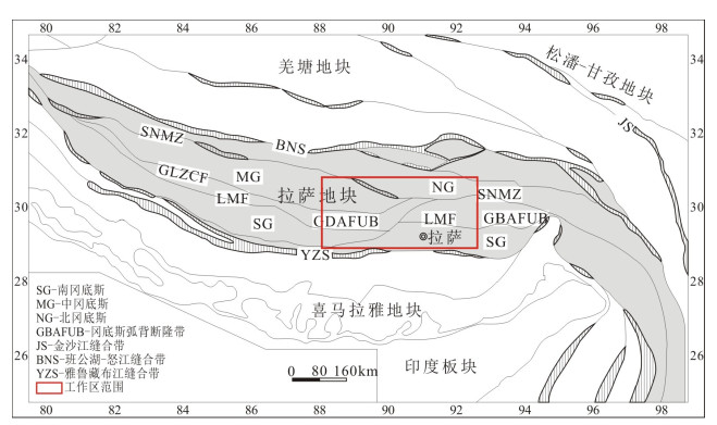
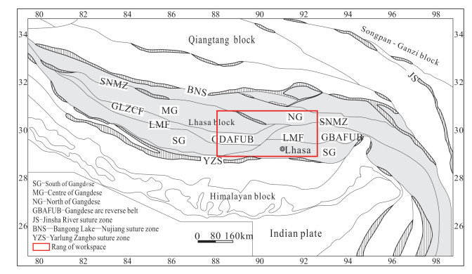
图 1 冈底斯成矿带大地构造位置略图(据朱弟成等, 2008; 曹圣华等, 2012修改)
表 1 数据库(集)元数据简表
表 2 岩石主量元素数据数据表
表 3 岩石微量数据数据表
表 4 岩石Re-Os测年数据表
Table 1. Metadata table of dataset(s)
Table 2. The data table contents of major element_Gangdise
Table 3. The data table contents of trace element_Gangdise
Table 4. The data table contents of Re-Os isotope geochronology_Gangdise
-
曹圣华. 2012. 西藏尼雄式铁矿及冈底斯中部铁铜矿区域成矿规律研究[D]. 北京: 中国地质大学(北京)博士论文, 12-27.
http://cdmd.cnki.com.cn/article/cdmd-11415-1012364483.htm 任金卫, 沈军, 曹忠权, 汪一鹏.2000.西藏东南部嘉黎断裂新知[J].地震地质, 22(4):334-350. http://kns.cnki.net/KCMS/detail/detail.aspx?filename=dzdz200004001&dbname=CJFD&dbcode=CJFQ
杨德明, 和钟铧. 2004. 西藏1: 25万门巴区幅区调报告[R]. 吉林大学地质调查院.
叶培盛. 2004. 拉萨地块中部蛇绿岩与逆冲推覆构造[D]. 北京: 中国地质科学院博士学位论文, 63-104.
http://cdmd.cnki.com.cn/Article/CDMD-82501-2007213421.htm 袁万明, 侯增谦, 李胜荣, 王世成.2002.雅鲁藏布江逆冲带活动的裂变径迹定年证据[J].科学通报, 47(2):147-149. https://wuxizazhi.cnki.net/qikan-HJSU200206009.html
翟文建, 崔霄峰, 岳国利, 杜欣, 王琰, 陈志敏, 苏建仓.2012.西藏扎雪-门巴韧性剪切带变形时代及机制研究:来自同构造花岗岩体的证据[J].大地构造与成矿学, 36(2):149-156. http://kns.cnki.net/KCMS/detail/detail.aspx?filename=dgyk201202003&dbname=CJFD&dbcode=CJFQ
张认, 和钟铧.2007.西藏冈底斯带扎雪-门巴韧性变形带形成时代及构造背景[J].沉积与特提斯地质, 27(1):19-24. http://kns.cnki.net/KCMS/detail/detail.aspx?filename=ttsd200701003&dbname=CJFD&dbcode=CJFQ
朱弟成, 潘桂棠, 王立全, 莫宣学, 赵志丹, 周长勇, 廖忠礼, 董国臣, 袁四化.2008.西藏冈底斯带中生代岩浆岩的时空分布和相关问题的讨论[J].地质通报, 27(9):1535-1550. http://kns.cnki.net/KCMS/detail/detail.aspx?filename=zqyd200809015&dbname=CJFD&dbcode=CJFQ
Cao Shenghua. 2012. Study on Regional Metallogenic Regularity of Iron Ore Deposit in the Central Iron Ore Deposit of Nixiong and Gangdise in Tibet[D]. Beijing: China University of Geosciences, 12-27(in Chinese with English abstract).
Ren Jinwei, Shen Jun, Cao Zhongquan, Wang Yipeng.2000.Quaternary faulting of Jiali Fault, southeast Tibetan plateau[J].Seismology and Geology, 22(4):334-350(in Chinese with English abstract). http://en.cnki.com.cn/Article_en/CJFDTOTAL-DZDZ200004001.htm
Yang Deming, He Zhonghua. 2004. The Report on the Area of 1: 250, 000 about Menba in Tibet[R]. Geological Survey Institute of Jilin University (in Chinese).
Ye Peisheng. 2004. Ophiolites and Thrust System of Middle Lhasa Block[D]. Beijing: Chinese Academy of Geological Sciences, 63-104(in Chinese with English abstract).
Yuan Wanming, Hou Zengqian, Li Shengrong, Wang Shicheng.2002.Fission track dating evidence on thrust belt activity of the Yarlung Zangbo River[J].Chinese Science Bulletin, 47(2):147-149(in Chinese with English abstract). https://www.researchgate.net/publication/227122151_Apatite_fission_track_dating_evidence_on_the_tectonization_of_Gangdese_block_south_Qinghai-Tibetan_Plateau
Zhai Wenjian, Cui Xiaofeng, Yue Guoli, Du Xin, Wang Yan, Chen Zhimin, Su Jiancang.2012.Age and Genetic mechanism of the Zhaxue-Menba shear zone in Tibet:Evidence from the synorogenic granites[J].Geotectonica et Metallogenia, 36(2):149-156(in Chinese with English abstract). http://en.cnki.com.cn/Article_en/CJFDTotal-DGYK201202003.htm
Zhang Ren, He Zhonghua.2007.The ages and tectonic setting of the Zhaxue-Menba ductile shear zone in the Gangdise orogenic belt, Tibet[J].Sedimentary Geology and Tethyan Geology, 27(1):19-24(in Chinese with English abstract). http://en.cnki.com.cn/Article_en/CJFDTOTAL-TTSD200701003.htm
Zhu Dicheng, Pan Guitang, Wang Liquan, Mo Xuanxue, Zhao Zhidan, Zhou Changyong, Liao Zhongli, Dong Guochen, Yuan Sihua.2008.Tempo-spatial variations of Mesozoic magnmtic rocks in the Gangdise bell Tibet, China, with a discussion of geodyrmmic setting-related issues[J].Geological Bulletin of China, 27(9):1535-1550(in Chinese with English abstract).
-