

China National Digital Geological Map (Public Version at 1:200 000 Scale) Spatial Database
-
摘要:
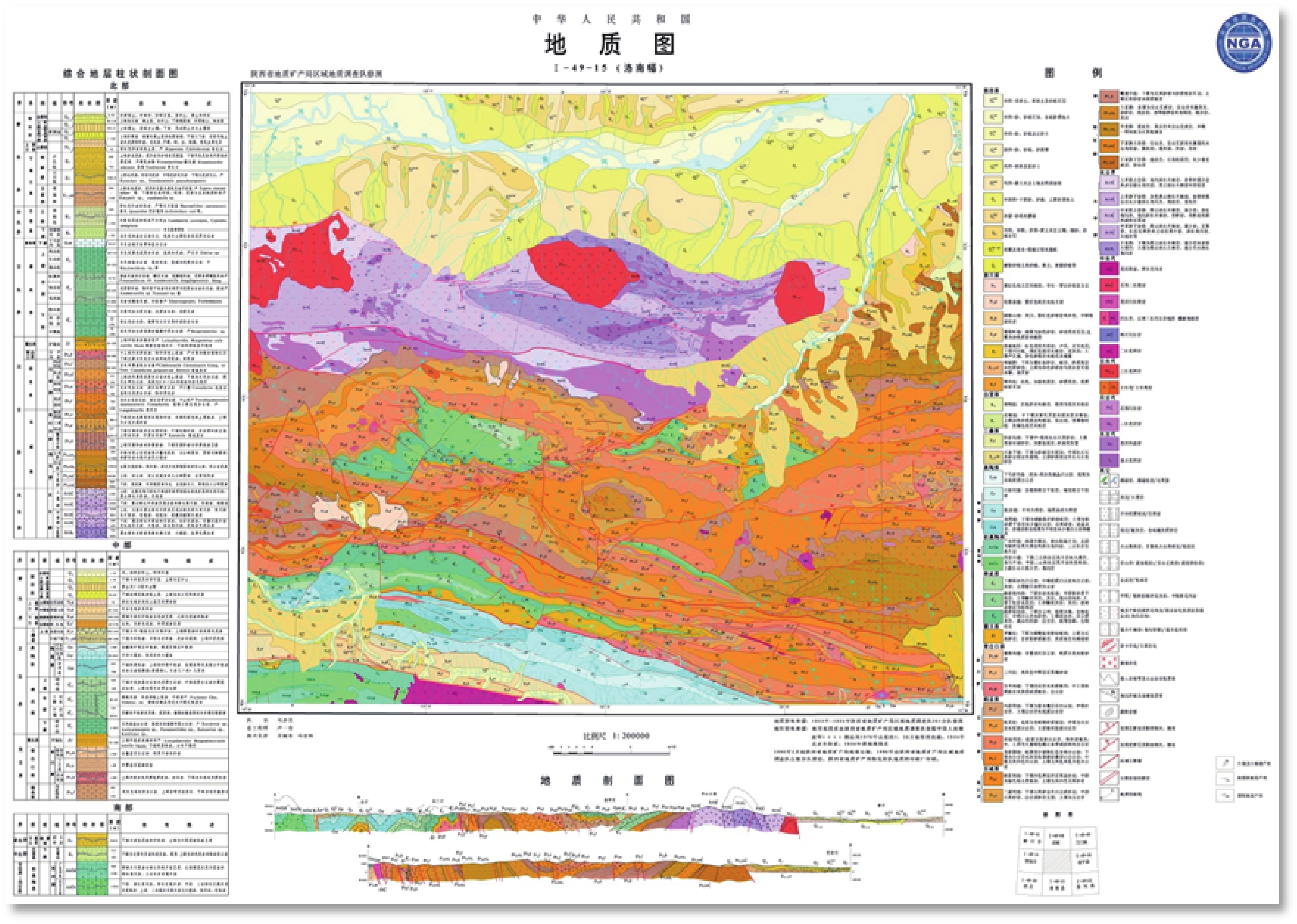
全国1:200 000数字地质图空间数据库是基于目前中国唯一的、实测的、全国性的1:200 000区域地质调查成果,由全国多家单位共同完成的全国性基础地质学空间数据库之一。数据库在空间上包含1 163幅1:200 000地质图数据,覆盖整个国土范围的72%,包含MapGIS和ArcGIS两种格式,总数据量达到90 GB。数据库主要资料来源于1:200 000区域地质调查报告和地质图及矿产图,原始资料时间跨度从20世纪50年代中期到90年代初期。全国1:200 000数字地质图(公开版)空间数据库通过国家级验收,数据完整性、逻辑一致性、位置精度、属性精度、接缝精度均符合中国地质调查局制定的有关技术规定和标准的要求,质量优良可靠。全国1:200 000数字地质图空间数据库是国家空间数据的重要组成部分,为国民经济信息化提供数字化空间平台,为国家和省级各部门进行区域规划、地质灾害监测、地质调查、找矿勘查、宏观决策等提供信息服务。
-
关键词:
- 1:200 000数字地质图 /
- 空间数据库 /
- 地理信息系统
Abstract:As the only one of its kind, China National Digital Geological Map (Public Version at 1:200000 scale) Spatial Database (CNDGM-PVSD) is based on China's former nationwide measured results of regional geological survey at 1:200 000 scale, and is also one of the nationwide basic geosciences spatial databases jointly accomplished by multiple organizations of China. Spatially, it embraces 1163 geological map-sheets (at scale 1:200 000) in both formats of MapGIS and ArcGIS, covering 72% of China's whole territory with a total data volume of 90 GB. Its main sources is from 1:200 000 regional geological survey reports, geological maps, and mineral resources maps with an original time span from mid-1950s to early 1990s. Approved by the State's related agencies, it meets all the related technical qualification requirements and standards issued by China Geological Survey in data integrity, logic consistency, location accuracy, attribution fineness, and collation precision, and is hence of excellent and reliable quality. The CNDGM-PVSD is an important component of China's national spatial database categories, serving as a spatial digital platform for the information construction of the State's national economy, and providing information backbones to the national and provincial economic planning, geohazard monitoring, geological survey, mineral resources exploration as well as macro decision-making.
-

-
表 1 数据库(集)元数据简表
条目 描述 数据库(集)名称 全国1∶200 000数字地质图(公开版)空间数据库 数据库(集)作者 李晨阳,中国地质调查局发展研究中心
王新春,中国地质调查局
何春珍,中国地质调查局发展研究中心
吴 轩,中国地质调查局发展研究中心
孔昭煜,中国地质调查局发展研究中心
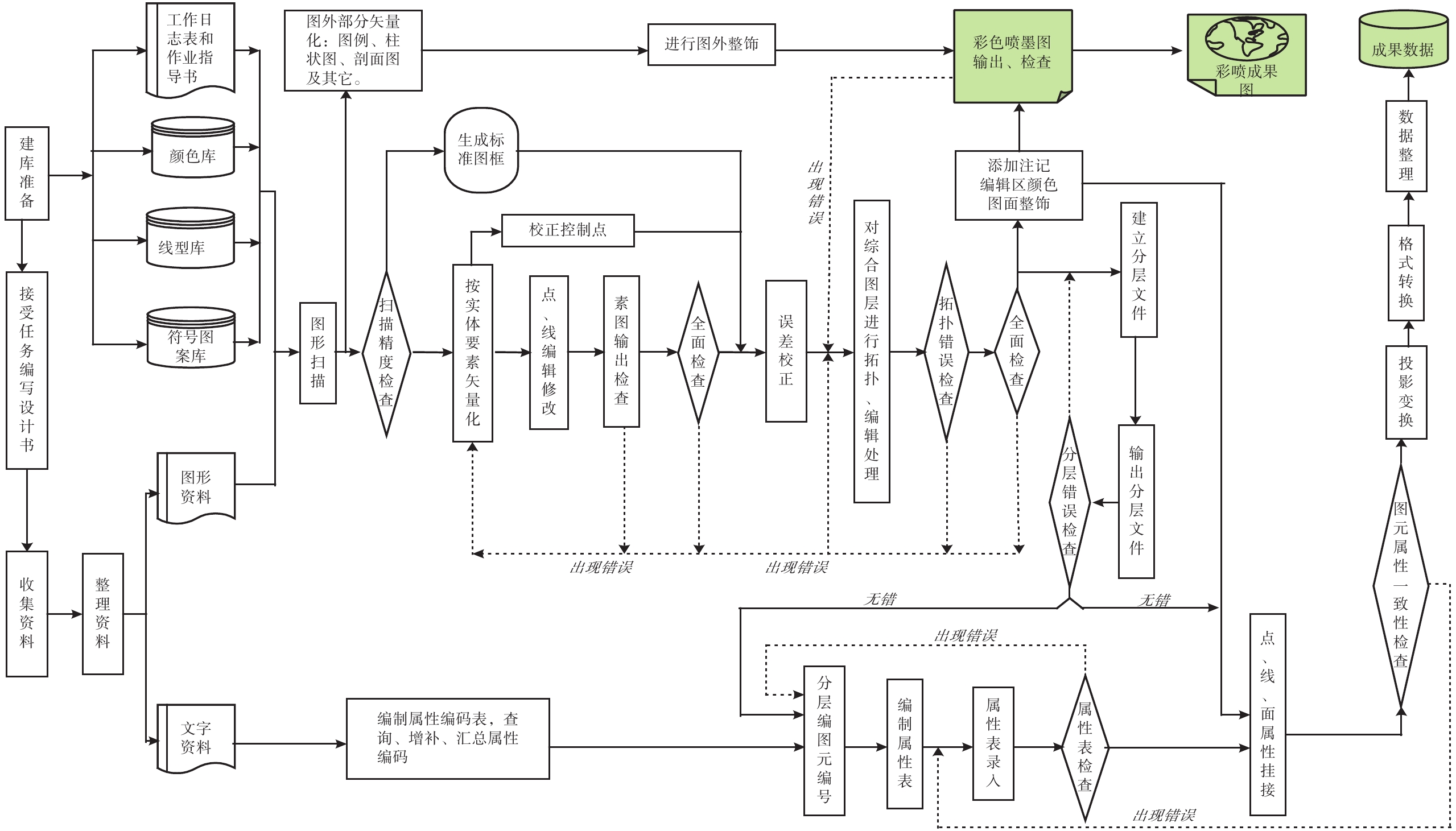
李晓蕾,中国地质调查局发展研究中心数据时间范围 1957—1995 年 地理区域 全国1∶200 000国际分幅数字地质图研究区范围为中华人民共和国陆域部分为主。经度范围为:东经72°~138°,北纬16°~56°,采用1∶200 000地形图的分幅编号 数据格式 .mpj, .shp, .doc 数据量 90 GB 数据服务系统网址 http://dcc.cgs.gov.cn 基金项目 原地质矿产部地质调查局、中国地质调查局委托项目(S3.2.1.1-27, 19961831004015-225, 199918310102-08, 19991831008015, 199918310120) 语种 中文 数据库(集)组成 数据集由1 163幅1∶200 000地质图数据组成,每个地质图数据(即一个图幅)包含如下文件:一个图幅栅格数据文件、全要素矢量化地质图数据文件、MapGIS各图层数据文件(包括高斯\经纬度两种格式数据)、ArcInfo各图层数据文件、E00数据文件、属性库(*.DBF),主要电子文档:元数据(图幅、分层、图层属性等说明)、说明文件(图饰图例库、修改字段、为制图要求添加注释图层等说明)。  下载: 导出CSV
表 2 参与数据建库的单位及各项目负责人员列表
序号 地区 建库图幅数量 建库项目参与单位 项目负责人 1 西藏部分 12 西藏自治区地质调查院 徐开锋 2 西藏部分 16 山东省国土资源信息中心 李军 3 山东部分 15 山东地勘局遥感中心 李军 4 山东部分 3 山东省地质科学实验研究院 5 山东部分 3 山东地矿信息中心 6 山东部分 3 山东省第七地质勘查院 7 江苏部分 14 江苏省地质调查研究院 姚文江 8 湖南部分 24 湖南省地质调查院 尹建生 9 四川部分 70 四川省地调院 何思彬 10 四川部分 10 四川省地矿局化探队 11 甘肃部分 76 甘肃省地质调查院 徐东、李文胜 12 吉林部分 34 吉林省地质调查院 刘建民 13 黑龙江部分 15 黑龙江省地调院,齐齐哈尔分院 王月平、马丽玲 14 内蒙古部分 68 内蒙古自治区地质调查院 赵军 15 山西部分 9 山西省地质调查院 孙春娟 16 湖北部分 20 湖北省地质调查院 宋丽霞 17 广西部分 48 广西壮族自治区地质调查研究院 李文鑫、马隆文 18 安徽部分 35 安徽省地质调查院 曹静平、胡海风、许卫 19 陕西部分 33 陕西省地质调查院 蔡波、谢晓波 20 青海部分 66 青海省地质调查院 侯元才、郝维杰、祁兰英 21 新疆部分 120 新疆维吾尔自治区地质调查院 肖志坚 22 辽宁部分 41 辽宁省地质矿产研究院 杨光时 23 海南部分 11 海南省地质调查院 何国伟 24 浙江部分 28 浙江省地质调查院 蔡子华 25 江西部分 30 江西省地质调查院
江西省地勘局地勘信息中心顾敏 26 河南部分 14 河南省地质调查院 蒙胜华 27 广东部分 42 广东省地质调查院 邓勇 28 河北部分 26 河北省地质调查院 胡殿常 29 云南部分 40 云南省地勘局区调队
云南省地勘局信息中心
云南省地勘局第一、二、三、四、五地质队何家学、谢蕴宏 30 宁夏部分 19 宁夏回族自治区地质调查院 李天斌 31 贵州部分 41 贵州省地质调查院 张泽标 32 福建部分 31 福建省地质调查研究院 潘金滇、张顺金、李建豪
下载: 导出CSV
表 1 Metadata Table of Database (Dataset)
Items Description Database(dataset) name China National Digital Geological Map (Public Version at 1∶200 000 Scale) Spatial Database Database(dataset) authors Li Chenyang, Development and Research Center of China Geological Survey
Wang Xinchun, China Geological Survey
He Chunzhen, Development and Research Center of China Geological Survey
Wu Xuan, Development and Research Center of China Geological Survey
Kong Zhaoyu, Development and Research Center of China Geological Survey
Li Xiaolei, Development and Research Center of China Geological SurveyData acquisition time 1957—1995 Geographic area Mainly the land area of the People's Republic of China of 72°~138°E and 16°~56°N; all the map-sheets at scale of 1∶200 000 are coded. Data format .mpj, .shp, .doc Data size 90 GB Data service system URL http://dcc.cgs.gov.cn Fund project The Geological Survey of the Former Ministry of Geology and Mineral Resources Project and China Geological Survey Project (S3.2.1.1-27, 19961831004015-225, 199918310102-08, 19991831008015, 199918310120). Language Chinese Database(dataset) composition The dataset consists of 1 163 digital maps at scale of 1∶200 000; and each of the digital geological map (i.e. a map-sheet) contains the following files: a map-sheet grid data file, all-factor vectored geological map data files, MapGIS graphic layers data files (including data in both Gauss\meridian formats), ArcInfo graphic layer data, E00 data files, and attribute database (*.DBF). Main electronic documents: metadata (illustrations for map-sheet, graphic layer, and graphic layer attribute, etc.), illustrative documentation (on legends and decorations, modified field, annotation graphic layer for map-making).
下载: 导出CSV
表 2 Organizations and experts responsible for the 1∶200 000 CNDGM-PVSD
Serial No. Regions Map-sheets Amount Organizations Experts 1 Xizang 12 Xizang Institute of Geological Survey Xu Kaifeng 2 Xizang 16 Shandong Information Center of Land & Resources Li Jun 3 Shangdong 15 Remote Sensing Center, Shandong Bureau of Geological Exploration Li Jun 4 Shandong 3 Shandong Institute of Geological Sciences Experiment 5 Shandong 3 Shandong Information Center of Geology & Mineral Resources 6 Shandong 3 Shandong 7th Institute of Geological Exploration 7 Jiangsu 14 Jiangsu Institute of Geological Survey Yao Wenjiang 8 Hunan 24 Hunan Institute of Geological Survey Yin Jiansheng 9 Sichuan 70 Sichuan Institute of Geological Survey He Sibin 10 Sichuan 10 Geochemical Exploration Team of Sichuan Geology and Mineral Resources Exploration Bureau 11 Gansu 76 Gansu Institute of Geological Survey Xu Dong,
Li Wensheng12 Jilin 34 Jilin Institute of Geological Survey Liu Jianmin 13 Heilongjiang 15 Qiqihar Branch of Heilongjiang Institute of Geological Survey Wang Yuping,
Ma Liling14 Inner Mongolia 68 Inner Mongolia Institute of Geological Survey Zhao Jun 15 Shanxi 9 Shanxi Institute of Geological Survey Sun Chunjuan 16 Hubei 20 Hubei Institute of Geological Survey Song Lixia 17 Guangxi 48 Guangxi Institute of Geological Survey Li Wenxin,
Ma Longwen18 Anhui 35 Anhui Institute of Geological Survey Cao Jingping, Hu Haifeng, Xu Wei 19 Shaanxi 33 Shaanxi Institute of Geological Survey Cai Bo, Xi Xiaobo 20 Qinghai 66 Qinghai Institute of Geological Survey Hou Yuancai,
Hao Weijie, Qi Lanying21 Xinjiang 120 Xinjiang Institute of Geological Survey Xiao Zhijian 22 Liaoning 41 Liaoning Institute of Geology and Mineral Resources Yang Shiguang 23 Hainan 11 Hainan Institute of Geological Survey He Guowei 24 Zhejiang 28 Zhejiang Institute of Geological Survey Cai Zihua 25 Jiangxi 30 Jiangxi Institute of Geological Survey, Information Center of Jiangxi Geological Exploration Bureau Gu Min 26 Henan 14 Henan Institute of Geological Survey Meng Shenghua 27 Guangdong 42 Guangdong Institute of Geological Survey Deng Yong 28 Hebei 26 Hebei Institute of Geological Survey Hu Dianchang 29 >Yunnan 40 Regional Geological Survey Team of Yunnan Geological Exploration Bureau, Information Center of Yunnan Geological Exploration Bureau, The 1st, 2nd, 3rd, 4th and 5th Geological Teams of Yunnan Geological Exploration Bureau He Jiaxue,
Xie Yunhong30 Ningxia 19 Ningxia Institute of Geological Survey Li Tianbin 31 Guizhou 41 Guizhou Institute of Geological Survey Zhang Zebiao 32 Fujian 31 Fujian Institute of Geological Survey Pan Jindian, Zhang Shunjin, Li Jianhao
下载: 导出CSV
-
[1] 李军. 2006. 数字地质图空间数据库建设与质量控制[D]. 长春: 吉林大学.
http://cdmd.cnki.com.cn/Article/CDMD-10183-2006108871.htm [2] 刘锋英, 王新春, 李晨阳, 何春珍. 2002. 全国1∶20万数字地质图空间数据库建设技术平台[J]. 国土资源信息化, (6): 19−23. http://d.old.wanfangdata.com.cn/Periodical/gtzyxxh200206004
[3] 刘英才. 2013. 东北地区1∶20万区域地质图空间数据库元数据建设[J]. 地质与资源, 22(5): 415−418. doi: 10.3969/j.issn.1671-1947.2013.05.012
[4] 唐海燕. 2002. 《全国1∶20万数字地质图空间数据库》顺利通过成果评审并投入使用[J]. 江苏地质, (3): 153. http://www.cnki.com.cn/Article/CJFDTotal-JSDZ200203007.htm
[1] Li Jun. 2006. The Spatial Database Construction and Quality Monitoring of the Digital Geological Map [D]. Changchun: Jilin University (in Chinese).
[2] Liu Fengying, Wang Xinchun, Li Chenyang, He Chunzhen. 2002. National 1∶200 000 Digital Geological Map Spatial Database Construction Technology Platform[J]. Land and Resources Informationzation, (6): 19−23 (in Chinese). http://d.old.wanfangdata.com.cn/Periodical/gtzyxxh200206004
[3] Liu Yingcai. 2013. Metadata Construction for the Spatial Database of 1∶200 000 Regional Geologic Map of Northeast China [J]. Geology and Resources, 22(5): 415−418 (in Chinese with English abstract).
10.3969/j.issn.1671-1947.2013.05.012 [4] Tang Haiyan. 2002. ‘National 1∶200 000 Digital Geological Map Spatial Database’ Passed the Assessment and Put into Practical Application[J]. Jiangsu Geology, (3): 153 (in Chinese). http://www.cnki.com.cn/Article/CJFDTotal-JSDZ200203007.htm
-


图(4)
表(4)
计量
- 文章访问数: 14359
- PDF下载数: 880
- 施引文献: 0