The 1:50 000 Mineral Geological Map Dataset of the Qingtang Map-sheet, Ningdu, South Jiangxi
-
摘要:
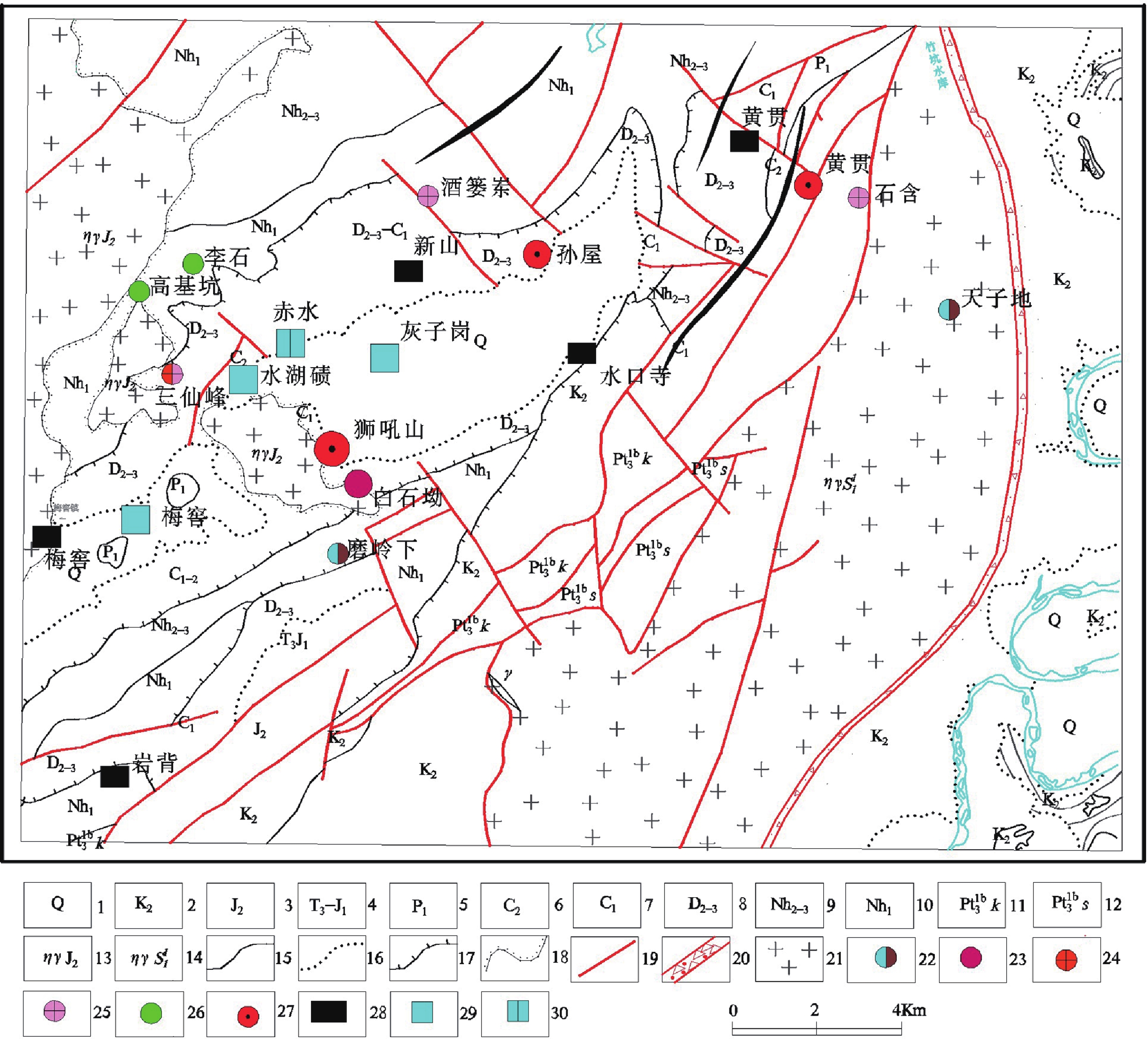
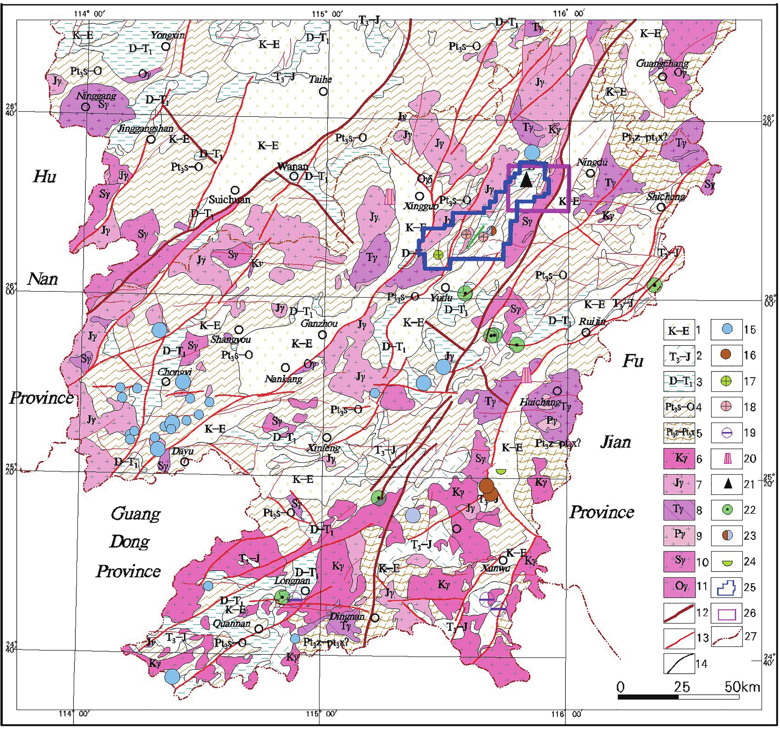
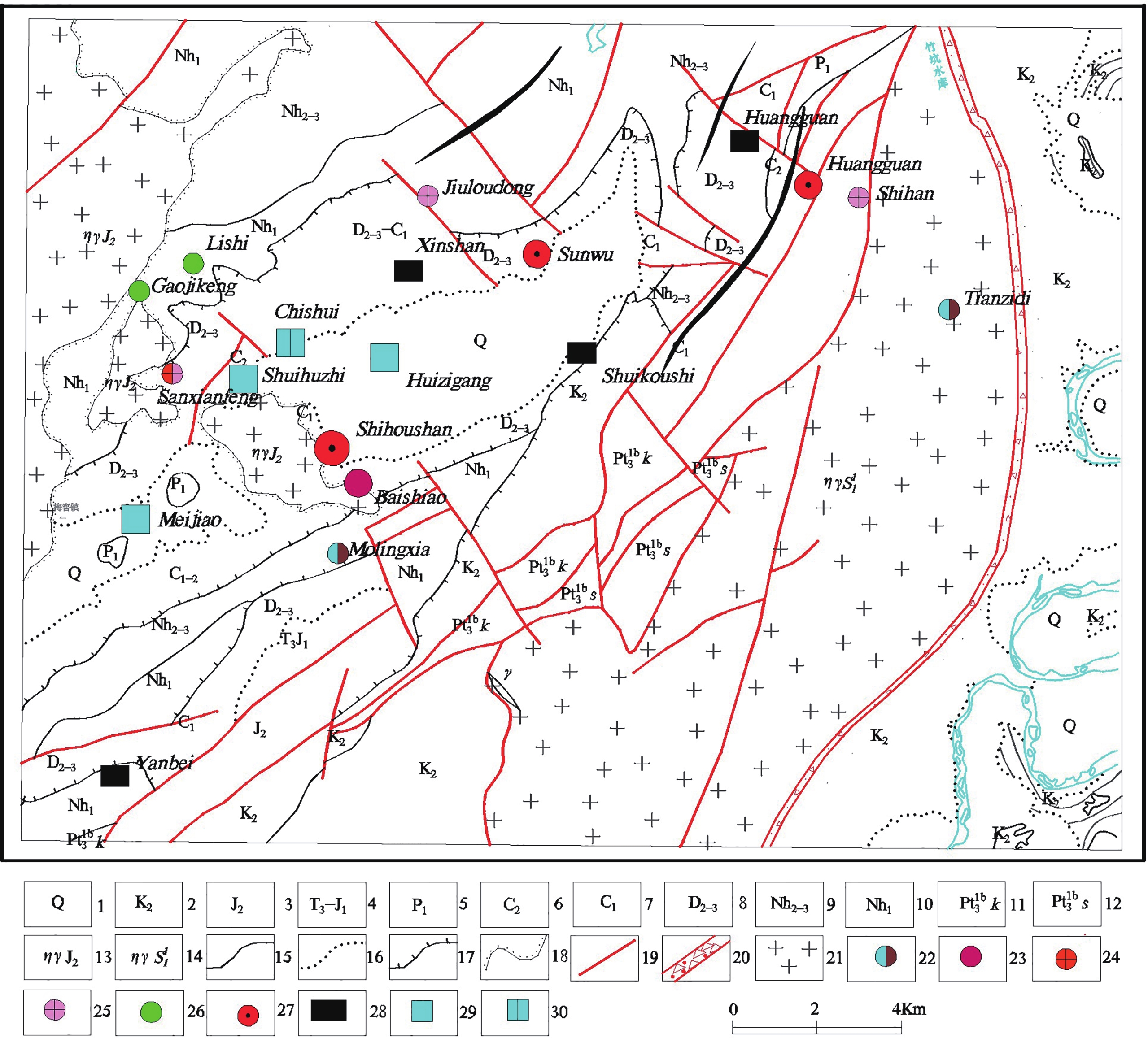
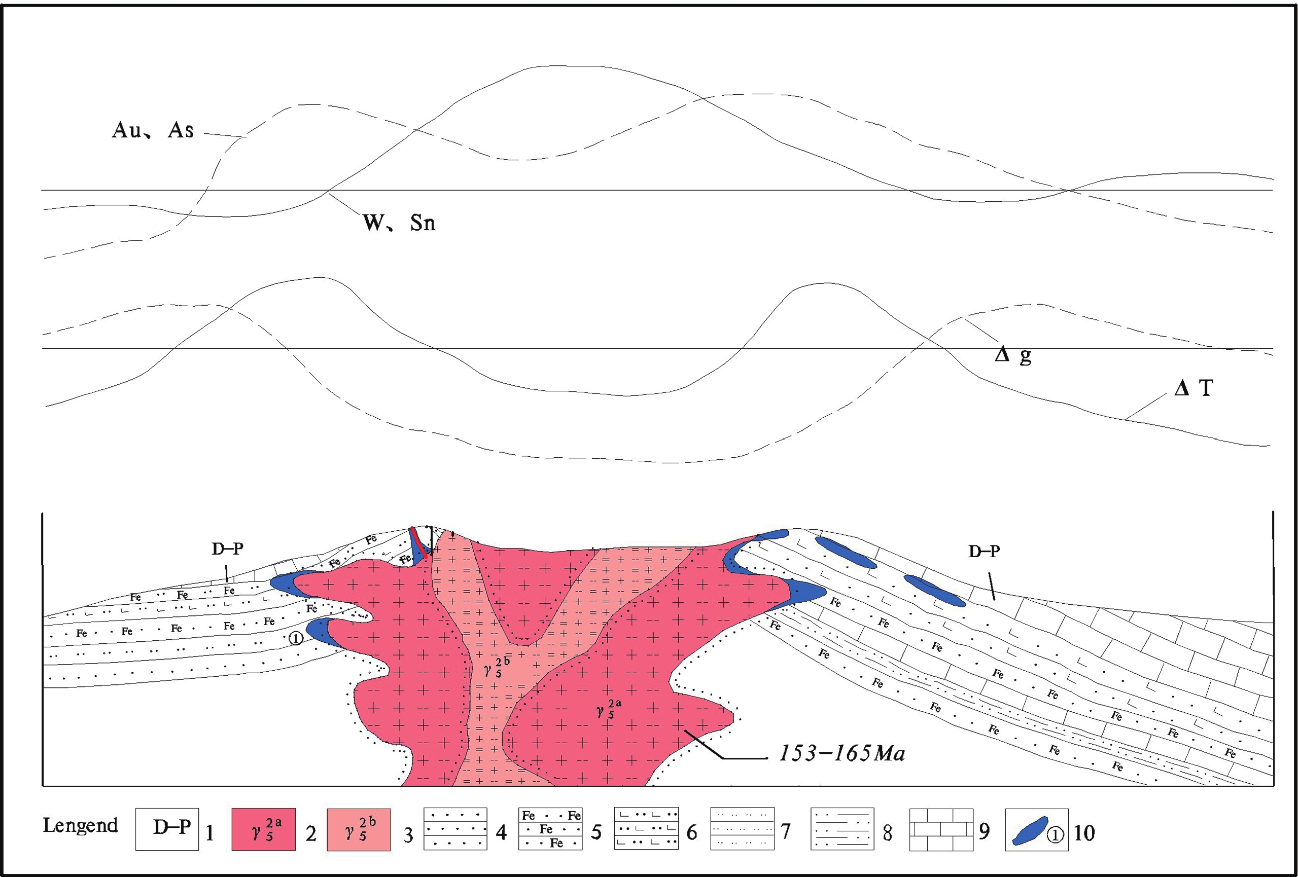
青塘幅位于江西南部于都银坑-宁都青塘整装勘查区北部,于山成矿亚带的北部。本次工作采用了岩性-构造-蚀变矿化专项填图、遥感、物探、化探、钻探等多种方法进行数据采集,完成了矿产地质路线调查长度533.68 km,采集水系沉积物样品1 729件,完成1:50 000地面高精度磁法测量458 km2,遥感数据解译面积458 km2,钻探施工422 m,化学分析样119件。数据集重点对燕山期早阶段成矿岩浆岩、含矿建造、控岩控矿构造及矿化蚀变标志等进行了调查划分,明确黑云母花岗岩为矽卡岩型硫铁钨多金属矿的成矿地质体,主要成矿结构面为梓山组上段的硅钙异性界面,蚀变以矽卡岩化、大理石化等为主;编制了青塘幅建造构造图,创建了区内矿产数据库,汇编了主要建造构造、断裂、地质界线、岩浆岩等属性特征;完善了狮吼山式矽卡岩型硫铁钨多金属矿床找矿预测模型,突出了区内矿产与建造构造之间的成因联系。
Abstract:The Qingtang map-sheet is located to the north of the Yudu Yingkeng-Ningdu Qingtang integrated survey area, south Jiangxi, and in the north of the Yushan metallogenic sub-zone. To develop this dataset, data were acquired comprehensively by using multiple methods such as mapping specific to lithology-structures-altered mineralization, remote sensing, geophysical/geochemical and drilling exploration. A route of 533.68 km was surveyed for mineral geology, with 1 729 stream sediment samples and 119 chemical analytical samples collected, 458 km2 of land measured with the 1:50 000 ground high-precision magnetic method and interpreted based on remote-sensing data, as well as 422m of depth drilled. In the dataset, emphasis is placed on survey and division of early-Yanshanian metallogenic magmatite, ore-bearing formations, rock-controlled and ore-controlled structures, and mineralized alteration marks etc. It is clear that biotite granite is a metallogenic geologic body of skarn-type S-Fe-W multi-metal ores, the main metallogenic structural plane is the Si-Ca heterologous interface in the upper part of the Zishan Formation, and alteration is mainly through skarnization, marbleization etc. The project team has plotted the Qingtang Map-sheet formation and structural map, created the mineral database of the area, and compiled properties of the main formation structures, fractures, geological boundaries and magmatite etc. This has improved the prospecting prediction model for Shihoushan-styled, S-Fe-W multi-metal deposits and highlighted the causal relationship between deposits and tectonic formations in the area.
-

-
表 1 数据库(集)元数据简表
条目 描述 数据库(集)名称 赣南宁都地区1∶50 000青塘幅矿产地质图数据集 数据库(集)作者 刘翠辉,江西省地质矿产勘查开发局赣南地质调查大队
李 伟,江西省地质矿产勘查开发局赣南地质调查大队
于长琦,江西省地质矿产勘查开发局赣南地质调查大队
贺根文,江西省地质矿产勘查开发局赣南地质调查大队
刘孝滨,江西省地质矿产勘查开发局赣南地质调查大队数据时间范围 2016.05—2019.01 地理区域 江西省赣州市,东经115°45′~116°00′,北纬26°20′~26°30′ 数据格式 *.wp,*.wl,*.wt,*.docx 数据量 47.2 MB 数据服务系统网址 http://dcc.cgs.gov.cn 基金项目 中国地质调查局地质调查项目“整装勘查区找矿预测与技术应用示范”子项目(121201004000150017-14)资助 语种 中文 数据库(集)组成 该数据集主要由矿产地质图(MapGIS格式)及矿产信息卡片(Word格式)组成。矿产地质图主要由主图、综合柱状图、镶图、地质构造格架剖面图、成矿区带图及图例组成。镶图包括牛形坝银金和狮吼山矽卡岩型硫铁多金属2个典型矿床的平面图和剖面图;图例包括构造、蚀变矿化、岩脉、矿产图例;修饰内容主要包括责任表、中国地质调查局局徽及图幅索引。青塘幅矿产信息卡片汇编了图幅内主要的矿床、矿点情况,包括金属矿产、能源矿产和非金属矿产,共14个矿区的基本矿产地质信息。 表 2 狮吼山式矽卡岩型硫铁多金属矿预测要素表
预测要素 描述内容 分类 成矿地质背景 大地构造位置 武夷隆起西缘,宁都−南城拗陷断束南端和信丰−于都拗陷褶束交接部位的青塘−银坑拗陷带 重要 区域成矿带 雩山隆褶带W−Ag−Pb−Zn−Au−Sn成矿亚带 重要 岩浆岩带 于山岩浆岩褶隆带 重要 成矿时代 燕山期早阶段 重要 矿床
特征成矿地质体 茶山迳复式岩体:燕山期花岗岩斑状黑云母花岗岩、细粒二长花岗岩 必要 含矿建造 梓山组上段含铁含钙碎屑岩建造 重要 成矿构造及结构面 成矿构造:石炭系梓山组内顺层破碎带,岩体侵入接触构造;成矿结构面:梓山组上段含钙细碎屑岩内硅钙异性界面 重要 成矿作
用特征矿体
特征矿体以似层状、透镜状产出为主,沿走向及倾斜方向上具膨大缩小、分支复合及尖灭再现等现象,产状基本与地层产状一致,走向长2 300米以上。 重要 矿物
组合磁黄铁矿、黄铁矿、黄铜矿、黑钨矿、白钨矿、石英、方解石、白云母、绢云母、黑云母、红柱石、萤石等 必要 主金属
元素Fe、S、W、Au、Cu 次要 矿床分
带性靠近岩体附近,矿床矽卡岩化、角岩化蚀变较强,矿化也较好;远离岩体,蚀变减弱,矿化变差 重要 蚀变
类型矽卡岩化、大理岩化、黄铁矿化、磁黄铁矿矿化、绿泥石化、碳酸盐化、硅化、云英岩化、红柱石角岩化等 重要 成矿模式 岩浆期后热液充填交代层控矽卡岩型含铜磁黄铁矿(伴生金)矿床 重要 物化遥综合信息 化探异常 Au、Pb、As、W、Sn等元素水系沉积物化探异常 重要 物探异常 岩体位于负重力异常区;矿体位于正负磁异常变化部位,最高100nT以上。 重要 遥感异常 环形构造,羟基、铁染异常明显 重要 表 3 青塘幅矿产地质图建造构造图层属性表
序号 数据项名称 标准编码 数据类型 实例 1 地质体面实体标识号 Feature_Id 字符串 AG50E010008000000484 2 地质体面实体类型代码 Feature_Type 字符串 C1z2 3 地质体面实体名称 Geobody_Name 字符串 下石炭统梓山组上段 4 地质体面实体时代 Geobody_Era 字符串 C1 5 建造大类 Formation 字符串 沉积岩建造 6 建造类型 Metallogenic 字符串 含铁砂岩建造 7 岩石组合 Combination 字符串 铁质粉砂岩、钙质粉砂岩、页岩、细粒石英砂岩 8 大地构造环境 Structural_Env 字符串 大地构造位置处武夷块体与罗霄块体的交接带上 表 4 青塘幅矿产地质图地质界线属性表
序号 数据项名称 标准编码 数据类型 实例 1 要素标识号 Feature_Id 字符串 AG50E010008000001489 2 地质界线(接触)代码 Feature_Type 字符串 F6 3 地质界线类型 Boundary_Name 字符串 断层接触 4 界线左侧地质体代号 Left_Boundary_Code 字符串 D2y 5 界线右侧地质体代号 Right_Boundary_Code 字符串 Nh1s 6 界面走向 Strike 整数型 30 7 界面倾向 Dip_Direction 整数型 300 8 界面倾角 Dip_Angle 整数型 60 表 5 青塘幅矿产地质图断裂属性表
序号 数据项名称 标准编码 数据类型 实例 1 要素分类代码 Feature_Type 字符串 F17 2 断层类型(地质代码) Fault_Type 字符串 F17 3 断层名称 Fault_Name 字符串 高岭−谢村断层F17 4 断层编号 Fault_Code 字符串 G50E010008F17 5 断层性质 Fault_Character 字符串 正断层 6 断层上盘地质体代号 Fault_Up_Body 字符串 Nh1s,Nh2-3s1 7 断层下盘地质体代号 Fault_Bottom_Body 字符串 Nh2-3s1,Nh1s 8 断层破碎带宽度 Fault_Wide 字符串 2~10 m 9 断层走向 Fault_Strike 整数型 60 10 断层倾向 Fault_Dip 整数型 330 11 断层面倾角 Fault_Dip_Angle 整数型 50 12 估计断距 Fault_Distance 浮点型 1 000 m 13 断层形成时代 Era 字符串 燕山期 14 活动期次 Movement_Period 字符串 燕山期 表 6 青塘幅矿产地质图矿产地属性表
序号 数据项名称 标准编码 数据类型 实例 1 要素标识号 Feature_Id 字符串 AG50E010008000000001 2 矿种代码 Feature_Type 字符串 3 070 3 矿种名称 Commodities_Name 字符串 S 4 共生矿 Paragenic_Ore 字符串 Fe 5 伴生矿 Associated_Ore 字符串 Au、W、Cu 6 矿产地数 Ore_Sums 整数型 1 7 矿石品位 Ore_Grade 字符串 TFe 41.413%、Cu 0.165%、WO 3 0.147%、Au 0.30g/t 8 规模 Deposite_Size 字符串 大型矿床 9 成矿时代 Metallogenetic_Epoch 字符串 燕山期晚阶段 10 矿产地名 Placename 字符串 狮吼山硫铁矿 11 矿化类型 Genesis_Types 字符串 矽卡岩型 12 成因类型 Industrial_Types 字符串 接触交代型 表 7 青塘幅矿产地质图侵入岩建造图层属性表
序号 数据项名称 标准编码 数据类型 实例 1 要素标识号 Feature_Id 字符串 AG50E010008000000001 2 岩体填图单位名称 Intru_Body_Name 字符串 茶山迳岩体 3 岩体填图单位符号 Intru_Body_Code 字符串 ηγJ2 4 岩石名称 Rock_Name 字符串 中(中细)粒斑状黑云母二长花岗岩 5 岩石颜色 Color 字符串 肉红色 6 岩石结构 Rock_Texture 字符串 中(中细)粒似斑状结构 7 岩石构造 Rock_Structure 字符串 块状构造 8 主要矿物及含量 Primary_Mineral 字符串 斜长石35%、钾长石35%、石英25% 9 次要矿物及含量 Secondary_Mineral 字符串 黑云母5% 10 与围岩接触关系 Contact_Relation 字符串 侵入接触 11 形成时代 Era 字符串 燕山期 12 含矿性 Commodities 字符串 硫铁、钨 表 1 Metadata Table of Database (Dataset)
Items Description Database (dataset) name The 1∶50 000 Mineral Geological Map Dataset of the Qingtang Map-sheet, Ningdu, South Jiangxi Database (dataset) authors Liu Cuihui, South Jiangxi Geological Survey Battalion, Jiangxi Geological Mineral Survey Development Bureau
Li Wei, South Jiangxi Geological Survey Battalion, Jiangxi Geological Mineral Survey Development Bureau
Yu Changqi, South Jiangxi Geological Survey Battalion, Jiangxi Geological Mineral Survey Development Bureau
He Genwen, South Jiangxi Geological Survey Battalion, Jiangxi Geological Mineral Survey Development Bureau
Liu Xiaobin, South Jiangxi Geological Survey Battalion, Jiangxi Geological Mineral Survey Development BureauData acquision time 2016.05—2019.01 Geographic area Ganzhou City, Jiangxi Province; East Longitude: 115°45′~116°00′; North Latitude: 26°20′~26°30′ Data format *.wp, *.wl, *.wt, *.docx Data size 47.2 MB Data service system URL http://dcc.cgs.gov.cn Fund project China Geological Survey Project “Demonstration Sub-project of Prospecting Prediction and Technical Application in Integrated Survey Areas” (121201004000150017-14). Language Chinese Database (dataset) composition The dataset primarily consists of the mineral geological maps (MapGIS) and mineral information cards (Word). The mineral geological maps mainly include master maps, overall histograms, mosaic maps, the geological tectonic framework profile, metallogenic zone/belt maps and legends. Mosaic maps include plans and profiles of 2 typical deposits, the Niuxingba Au-Ag deposit and the Shihoushan skarn-type S-Fe multi-metal deposit; legends include those for tectonic, altered mineralization, vein and minerals; additional features mainly consist of the responsibility matrix, CGS logo and map-sheet index. The Qingtang map sheet information cards contain basic mineralogical information in the 14 mining areas, such as the main deposits and mineral occurrences in the map sheet, including metal, energy and non-metal minerals. 表 2 Components for the prediction of Shihoushan-styled skarn-type S-Fe multi-metal deposit
Element for prediction Description Classification Metallogenic geological background Geotectonic location Qingtang -Yinkeng depression zone, in the west margin of the Wuyi uplift, at the intersection of the south end of the Ningdu-Nancheng depression ‘fault bundle’ and the Xinfeng-Yudu depression fold. important Regional metallogenic zone W−Ag−Pb−Zn−Au−Sn metallogenic sub-zone of the Yu mountain uplift fold zone important Magmatite zone Yushan magmatite fold-uplift zone important Metallogenic epoch Early Yanshanian important Deposit feature Metallogenic geologic body Chashanjing-styled complex massif: Yanshanian granite porphyritic biotite monzonitic granite and fine-grain monzonitic granite necessary Ore-bearing formation Fe-bearing Ca-bearing clasolite in the upper part of the Zishan Formation important Metallogenic tectonic and structural place Metallogenic structure: bedding crushed zone within the Carboniferous system Zishan Formation, rock-mass intrusive contact structure; metallogenic structural plane: Si-Ca heterologous interface in the upper part of the Zishan Formation important Deposit feature Features of metallogenesis Features of mineral bodies Most mineral bodies are bedded and lentoid, there are phenomena such as expansion and contraction, branching and then combination, or thinning-out and recurrence in their strike and their slant direction; its altitude is basically consistent with the stratum’s altitude, and the strike is longer than 2 300 m. important Ore combination Magnetic pyrite, pyrite, chalcopyrite, wolframite, scheelite, quartz, calcite, muscovite, sericite, biotite, andalusite, fluorite etc. necessary Main metal elements Fe, S, W, Au, Cu secondary Deposit zonation Close to the rock mass, deposit is skarnized, hornfelsic alteration is strong, and mineralization is better; far from the rock mass, alteration becomes weak and mineralization weakens. important Alteration type Skarnization, marbleization, pyritization, magnetic pyritization, chloritization, carbonatization, silicification, greisenization and andalusite hornfelsic etc. important Metallogenic mode Post-magma-period hydrothermal-solution filling-and-replacement strata-bound skarn-type Cu-bearing magnetic pyrite (Au-associated) deposit important Combined information from geochemical and geophysical exploration and remote sensing Anomaly from geochemical exploration Anomaly of stream sediments of elements such as Au, Pb, As, W and Zn from geochemical and geophysical exploration important Anomaly from geophysical exploration Rock mass is located in the negative gravity anomaly area; mineral body is located in places where negative and positive magnetism anomaly changes, more than 100 nT at least. important Anomaly from remote sensing Structure in the shape of a ring, with a clear hydroxyl and iron-stained anomaly important 表 3 Property table of formation - tectonic map layer in the mineral geological map ofthe Qingtang map-sheet
No. Name of data item Standard code Data category Real example 1 Mark number of geological body’s planar map layer Feature_Id Character string AG50E010008000000484 2 Type code of geological body’s planar map layer Feature_Type Character string C1z2 3 Name of geological body’s planar map layer Geobody_Name Character string Upper part of late Carboniferous series Zishan Formation 4 Era of geological body/plane physical body Geobody_Era Character string C1 5 Formation category Formation Character string Sedimentary rock formation 6 Formation type Metallogenic Character string Fe-bearing sandstone formation 7 Rock combination Combination Character string Ferrous siltstone, calcareous siltstone, shale, fine-grain quartz sandstone 8 Geotectonic setting Structural_Env Character string Regarding its geotectonic location, it is located at the connecting zone between the Wuyi and Luoxiao blocks. 表 4 Geological boundary property table of the mineral geological map ofthe Qingtang map-sheet
No. Name of data item Standard code Data category Real example 1 Element identification number Feature_Id Character string AG50E010008000001489 2 geological boundary (contact) code Feature_Type Character string F6 3 geological boundary type Boundary_Name Character string Fault contact 4 code of geological body in the left of the boundary Left_Boundary_Code Character string D2y 5 code of geological body in the right of the boundary Right_Boundary_Code Character string Nh1s 6 Interface strike Strike Integer 30 7 Interface dip Dip_Direction Integer 300 8 Interface dip angle Dip_Angle Integer 60 表 5 Fracture property table of mineral geological map of the Qingtang map-sheet
No. Name of data item Standard code Data category Real example 1 Element classification code Feature_Type Character string F17 2 Fault type (geological code) Fault_Type Character string F17 3 Fault name Fault_Name Character string Gaoling - Xiecun fault F17 4 Fault code Fault_Code Character string G50E010008F17 5 Fault property Fault_Character Character string normal fault 6 Code of geological body overlying the fault Fault_Up_Body Character string Nh1s,Nh2-3s1 7 Code of geological body underlying the fault Fault_Bottom_Body Character string Nh2-3s1,Nh1s 8 Width of crushed zone of fault Fault_Wide Character string 2~10 m 9 Fault strike Fault_Strike Integer 60 10 Fault dip Fault_Dip Integer 330 11 Fault dip angle Fault_Dip_Angle Integer 50 12 Estimated fault displacement Fault_Distance Floating-point type 1 000 m 13 Era of fault generation Era Character string Yanshanian 14 Movement periods Movement_Period Character string Yanshanian 表 6 Deposit site property table of mineral geological map of the Qingtang map-sheet
No. Name of data item Standard code Data category Real example 1 Element identification number Feature_Id Character string AG50E010008000000001 2 Ore type code Feature_Type Character string 3 070 3 Ore name Commodities_Name Character string S 4 Paragenic ore Paragenic_Ore Character string Fe 5 Associated ore Associated_Ore Character string Au, W, Cu 6 Number of deposit sites Ore_Sums Integer 1 7 Ore grade Ore_Grade Character string TFe 41.413%, Cu 0.165%, WO 3 0.147%, Au 0.30g/t 8 Scale Deposite_Size Character string Large-sized deposit 9 Metallogenic epoch Metallogenic_Epoch Character string Late Yanshanian 10 Deposit site name Placename Character string Shihoushan S-Fe deposit 11 Mineralization types Genesis_Types Character string skarn-type 12 Genesis type Industrial_Types Character string Contact replacement type 表 7 Intrusive rock formation property table of mineral geological map ofthe Qingtang map-sheet
No. Name of data item Standard code Data category Real example 1 Element identification number Feature_Id Character string AG50E010008000000001 2 Name of rock mass mapped Intru_Body_Name Character string Chashanjing rock mass 3 Symbol of rock mass mapped Intru_Body_Code Character string ηγJ2 4 Rock name Rock_Name Character string Medium (medium-fine)-grain porphyritic biotite monzonitic granite- 5 Rock color Color Character string Pink 6 Rock texture Rock_Texture Character string Medium (mid-fine)-grain porphyritic-like texture 7 Rock structure Rock_Structure Character string Blocky structure 8 Primary mineral and content Primary_Mineral Character string Plagioclase: 35%; K-feldspar: 35%; quartz: 25% 9 Secondary mineral and content Secondary_Mineral Character string Biotite: 5% 10 Contact relation with wall rock Contact_Relation Character string Intrusive contact 11 Generation era Era Character string Yanshanian 12 Ore-bearing potential Commodities Character string S-Fe, W -
[1] 陈毓川, 陈郑辉, 曾载淋, 赵正, 赵斌, 王登红, 张永忠, 李建国, 周新鹏, 李江东. 2013. 南岭科学钻探第一孔选址研究[J]. 中国地质, 40(3): 659−670. doi: 10.3969/j.issn.1000-3657.2013.03.001 http://geochina.cgs.gov.cn/geochina/ch/reader/view_abstract.aspx?file_no=20130301&flag=1
[2] 王登红, 秦燕, 陈振宇, 侯可军. 2012. 赣南部分岩体的锆石铀-铅同位素年代学研究及其对成岩成矿机制的再认识[J]. 岩矿测试, 31(4): 699−704. doi: 10.3969/j.issn.0254-5357.2012.04.024
[3] 叶天竺, 韦昌山, 王玉往. 等. 2014. 勘查区找矿预测理论与方法(总论)[M]. 北京: 地质出版社.
[4] 叶天竺, 吕志成, 庞振山. 等. 2017. 勘查区找矿预测理论与方法(各论)[M]. 北京: 地质出版社.
[5] 赵正, 陈毓川, 郭娜欣, 陈郑辉, 王登红, 曾载淋, 何绍森. 2016. 南岭科学钻探(NLSD-1)矿化规律与深部找矿方向[J]. 中国地质, 43(5): 1613−1624. http://geochina.cgs.gov.cn/geochina/ch/reader/view_abstract.aspx?file_no=20160511&flag=1
[6] 赵正, 陈毓川, 曾载淋, 郭娜欣, 陈郑辉, 王登红, 刘翠辉, 刘宗翊, 王平安, 李江东. 2017. 江西银坑 W-Ag-Au多金属矿田成矿规律与找矿方向: 兼论华南两个成矿系列叠加问题[J]. 地学前缘, 24(5): 54−61. http://d.old.wanfangdata.com.cn/Periodical/dxqy201705006
[1] Chen Yuchuan, Chen Zhenghui, Zeng Zailin, Zhao Zheng, Zhao Bin, Wang Denghong, Zhang Yongzhong, Li Jianguo, Zhou Xinpeng, Li Jiangdong. 2013. Research on the site selection of Nanling Scientific Drilling-1[J]. Geology in China, 40(3): 659−670 (in Chinese with English abstract). doi: 10.3969/j.issn.1000-3657.2013.03.001 http://geochina.cgs.gov.cn/geochina/ch/reader/view_abstract.aspx?file_no=20130301&flag=1
[2] Wang Denghong, Qin Yan, Chen Zhenyu, Hou Ke. 2012. U-Pb Isotopic Age and a Further Understanding of the Ore-forming Mechanism in Granite from the Southern Jiangxi Province[J]. Rock and Mineral Analysis, 31(04): 699−704 (in Chinese with English abstract). doi: 10.3969/j.issn.0254-5357.2012.04.024
[3] Ye Tianzhu, Wei Changshan, Wang Yuwang. 2014. Prospecting Theory and Method for Prospecting in Exploration Area (pandect) [M]. Beijing:Geological Publishing House (in Chinese).
[4] Ye Tianzhu, Lv Zhicheng, Pang Zhenshan.2017. Prospecting Theory and Method for Prospecting in Exploration Area (monograph) [M]. Beijing:Geological Publishing House (in Chinese).
[5] Zhao Zheng, Chen Yuchuan, Guo Naxin, Chen Zhenghui, Wang Denghong, Zeng Zailin, He Shaosen. 2016. Ore-forming regularity and deep prospecting direction of Nanling Scientific Drilling-1(NLSD-1)[J]. Geology in China, 43(05): 1613−1624 (in Chinese with English abstract). http://geochina.cgs.gov.cn/geochina/ch/reader/view_abstract.aspx?file_no=20160511&flag=1
[6] Zhao Zheng, Chen Yuchuan, Zeng Zailin, Guo Naxin, Chen Zhenghui, Wang Denghong, Liu Cuihui, Liu Zongli, Wang Pingan, Li Jiangdong. 2017. Jiangxi Yinkeng W-Ag-Au ore field's metallogenic regularity and prospecting direction:as well as the superposition of two metallogenic series in Southern China[J]. Earth Science Frontiers, 24(05): 54−61 (in Chinese with English abstract).
-


 下载:
下载:


