The large deep-water turbidity fan system in southeastern South China Sea Basin: Formation and tectonic constraint
-
摘要:
运用近年来海洋地质调查工程获取的最新地质地球物理数据,在南海海盆东南部水深2000~3800 m区域,发现中中新世到第四纪多期大型浊积扇沉积体系,揭示了南海南部深海沉积作用及沉积演化过程。该浊积扇体系以沉积物波、水道充填、海底扇、块体流等沉积体为主,总体上由海盆东南部向海盆中央呈扇形推进,推进距离为150~ 260 km,从老到新规模和结构不断变化,蕴含了丰富的海平面变化信息。垂向上浊流沉积层层叠置发育,形成厚层的浊积砂体。海底水道十分发育,水道砂体底部呈“V”型展布,由南向北延伸,揭示出物源主要来自礼乐滩及北巴拉望区域。该浊积扇的形成明显受到构造控制,与中中新世以来礼乐滩—巴拉望岛的隆升和晚中新世以来的岩浆活动密不可分。浊流发育位置处于南海东南部陆缘和深海平原之间,是陆源物质由浅海输送到深海平原的重要机制,构成南海南部“源-汇”沉积体系的重要环节。
Abstract:A large turbidite fan system was found from southeastern South China Sea basin through the latest multi-channel seismic profiles in the regional geological and geophysical measurement data set. This fan system occurred in the water depth from 2000 m to 3800 m of the present sea level, with forward northwest direction to the central basin edge 150-260 km in length. The fan system was interpreted to have been formed from middle Miocene to Quaternary with series of turbidite fan sequences, mainly composed of sediment waves, channel filling, submarine fans, and mass flows. In time scale, from the early to late stage, the size and architecture of fan system were constantly changing, underlying valuable information of sea level change, depositional process and tectonic evolution. In spatial scale, the turbidite sand bodies were formed by the superimposed layers of turbidite flow sediments. The channels were well developed on the seabed within this fan system. The bottom of the channel sand bodies are distributed on "V" shape in panel, extending from south to north, revealing mainly sources from Liyue Bank and north Palawan Island area. The turbidite fan's formation was obviously controlled by tectonic movement, on the one hand related to the uplift of Liyue Bank-Palawan Island since the middle Miocene and, and on the other hand related to magmatic activity since the late Miocene. The turbidite current mechanism occurred in the transition of continental margin to abyssal plain in the southeast of the South China Sea, driving particles transportation from shallow sea to deep basin. This new interpreted large turbidite fan system presents an important linkage of "source-to-sink" sedimentary system, and benefits to revealing deep-sea sedimentary evolution process in the South China Sea.
-
1. 引言
雄安新区地处北京、天津、保定腹地,涉及河北省雄县、容城、安新3县及周边部分区域。为推动雄安新区规划建设,中国地质调查局部署实施了雄安新区地质调查工作,“雄安新区工程地质勘查”是其中主要工作之一,在实施工程地质钻探的基础上,获取工程地质层组信息,建立雄安新区工程地质三维结构模型。
雄安新区地理坐标为北纬38°41′~39°10′、东经115°37′~116°19′。地势西北高、东南低,地形坡降小于2‰。区内浅层沉积物主要为第四纪以来冲洪积、冲积和冲湖积物,以粉质黏土、粉土、粉砂、中细砂和黏土为主(郝爱兵等,2018;张竞等,2018)。
调查以查明工程地质条件与工程地质问题为目标,在2017年调查成果的基础上建立了雄安新区工程地质勘查数据集和模型,数据集及模型可直观地表达雄安新区工程地质结构,对规划和建设具有支撑和服务作用(李庆瑞,2017;林良俊等,2017),数据集及模型基本信息如表 1所示。
表 1. 数据库(集)元数据简表条目 描述 数据库(集)名称 雄安新区工程地质三维结构模型数据集 数据库(集)作者 马 震,中国地质调查局天津地质调查中心
夏雨波,中国地质调查局天津地质调查中心
王小丹,中国地质调查局天津地质调查中心数据时间范围 2017年 地理区域 东经115°37′~116°19′,北纬38°41′~39°10′ 数据格式 地质体格式为OBJ /Creatar,点集和面集格式为ArcGIS 数据量 16.5 MB 数据服务系统网址 http://dcc.cgs.gov.cn 基金项目 中国地质调查局地质调查项目“雄安新区工程地质与水土质量调查”(121201004000172201) 语种 中文 数据库(集)组成 包括地质体集、点集和面集3个数据集,地质体集包括18个地层地质体,点集包括乡镇.SHP和县.SHP,面集包括行政区顶面 2. 数据采集和处理方法
2.1 数据采集
雄安新区工程地质勘查数据以《城乡规划工程地质勘查规范》CJJ 57–2012为基本要求布置工程地质钻孔,以《工程地质钻探规程》(DZ/T 0017–1991)及《岩土工程勘察规范》(GB 50021–2001)(2009年版)的要求进行施工的,数据的采集按照《区域水文地质工程地质环境地质综合勘查规范(比例尺1∶50 000)》(GB/T 14158–93)的要求进行(龚磊,2019),全区勘查精度为1∶50 000,雄县、容城县、安新县县城等重点调查区勘察精度为1∶25 000,部分地区精度最高达1∶10 000。
2.1.1 高程系统和坐标系统
高程系统采用1985国家高程基准,坐标系统采用2000国家坐标系统。
2.1.2 钻孔编录采集信息
(1)分层与层厚
依据《岩土工程勘察规范》(GB 50021–2001) (2009版),岩层厚度大于1 m为巨厚层,0.5~1.0 m为厚层,0.1~0.5 m为中厚层,小于0.1 m为薄层。
(2)岩性
根据《岩土工程勘察规范》(GB 50021–2001) (2009版),进行第四系松散层岩性定名,岩性名称包括:砾石、粗砂、中砂、细砂、粉砂、粉土、粉质黏土、黏土。
(3)土的颜色
土的颜色定名采用中国科学院南京土壤研究所编制的《中国标准土壤色卡》。
(4)土体性质
采集内容包括砂性土、粉土和粘性土的密实度、湿度、分选性、磨圆度等。
(5)土的构造
采集水平层理、波状层理、交错层理、平行层理、斜层理、递变层理等层理构造和波痕、冲刷面、底砾层、压裂面等层面构造信息。
(6)土的包含物
钙质结核、铁锰结核、铁锰斑点、生物碎屑、植物根系、淤泥夹层、泥炭夹层、泥砾、高岭土等包含物特征。
2.1.3 工程点信息
每个钻孔的坐标及高程信息。
2.2 数据处理过程
2.2.1 资料整理与汇总
(1)数据录入
数据录入依照《重要经济区和城市群地质环境调查数据库建设指南》要求建设,对接三维地质结构软件建设进行录入,建立两个原始文件,分别为钻孔基本信息表、钻孔岩芯描述表。数据按照入库的格式提供统一文档进行录入,录入格式为excel的.xls或.xlsx。录入钻孔依次录入在同一个文档的工作簿(sheet)中。
(2)电子文档汇总
电子版文件包括钻孔基本信息表、钻孔岩芯描述表、岩芯照片、采样记录表(土工实验、易溶盐)。
2.2.2 钻孔地层划分
(1)标准层建立
根据沉积时代,将100 m以内地层时代自上而下划分为第四系全新统(Qh)、上更新统(Qp3)、中更新统(Qp2)、下更新统(Qp1)。
末次盛冰期,雄安新区位于太行山前,受到全球气候的影响,形成硬黏土。钙质硬黏土为标志层,作为Qh与Qp3地层划分的依据和标志。
第四纪气候以冰期和间冰期的旋回为主要特征,雄安新区晚更新世地层,虽不受到全球海平面变化的影响,但却受到气候变化的影响,尤其是冷期,多形成钙质淀积结核或钙质胶结层,第五层钙质淀积或结核层是Qp3与Qp2地层的界线,为划分Qp3和Qp2的标志层。
(2)钻孔地层概况
根据土体类型将三大工程地质层进一步划分为18个工程地质层组,根据主要岩性命名。其中,全新统(Qh)分为①填土、②粘性土+粉土、③粘性土+粉土、④粘性土+粉土,其中第②层与第④层为冲洪积,氧化或弱氧化条件,有机质含量少,第③层为湖相沉积,还原条件,为淤泥质粉质黏土,多软弱土,且第③层沉积条件与工程力学性质均与第②层和第④层有很大差别,因此该三层虽然名称相同,但不能合并为一层;上更新统(Qp3)分为⑤粘性土+粉土、⑥砂土,⑦粘性土+粉土、⑧砂土、⑨粘性土、⑩砂土、⑪粘性土;中更新统(Qp2)分为⑫粘性土、⑬砂土、⑭粘性土、⑮砂土;下更新统(Qp1)为⑯粘性土、⑰砂土、⑱粘性土。100 m内未揭露Qp1。
2.2.3 三维结构模型构建
(1)数据准备
三维模型构建主要数据源为标准化后的工程地质钻孔数据,数据存储格式为文本文件(*.txt),包括“钻孔基本信息.txt”和“钻孔分层信息.txt”2个文件。“钻孔基本信息.txt”数据文件(表 2),描述本次参与建模的所有钻孔的基本信息,每个钻孔为一行,包括钻孔编号、X坐标、Y坐标、孔口高程和孔深。“钻孔分层信息.txt”数据文件(表 3),描述本次参与建模钻孔的分层信息,主要包括钻孔编号、起始深度、终止深度、地层编号。
表 2. 钻孔基本信息序号 数据项名称 数据类型 实例 1 钻孔编号 字符串 G7039 2 X坐标 浮点型 406051.22 3 Y坐标 浮点型 4326929.35 4 孔口高程 浮点型 9.08 5 孔深 浮点型 100.14 表 3. 钻孔分层信息序号 数据项名称 数据类型 实例 1 钻孔编号 字符串 G7039 2 起始深度 浮点型 0.0 3 终止深度 浮点型 0.6 4 地层编号 浮点型 1 (2)模型构建
平原区工程地质结构多为第四系层状地层沉积,因此工程地质三维模型构建可采用自动建模的方法,即利用工程地质钻孔数据,由上到下将地层信息转换为空间二维离散点数据,再通过插值和拟合算法生成曲面,曲面间通过网格剖分进而生成地层实体,从而完成三维工程地质自动建模(张像源等,2013;刘顺昌等,2016)。
基于以上建模方法,选择“北京超维创想信息技术有限公司”研发的Creatar XModeling软件,按照以下步骤构建了雄安新区100 m以浅工程地质地层三维结构模型,即:首先导入钻孔基本信息及钻孔分层信息,构建三维工程地质钻孔模型,再导入矢量化的建模范围,确定参与建模的钻孔并进行钻孔解译,选择不同的插值方法及剖分网格大小,经过多次拟合调整,最终采用B样条插值方法,剖分网格500 m,自上而下,逐层构建了地质体。
(3)模型整饰
从天地图下载了建模区域的行政区划图,在ArcGIS软件中经过裁剪、投影、校正后导入面集,并贴合于三维模型表面。将研究区县级居民地和乡镇级居民地的ArcGIS矢量文件分别导入到点集中,并调整Z值以显示于模型地表以上(图 1)。
3. 数据样本描述
3.1 数据类型及命名
数据类型主要为数据集,共包括地质体集、点集和面集3个数据集。地质体集命名为“工程地质模型”,其中包括17个地层地质体,依次命名为“工程地质模型_地质体_1”至“工程地质模型_地质体_17”。点集命名为“居民地标注”,其中包括“乡镇.SHP”和“县.SHP”2个点文件,面集只有一个面文件,命名为“行政区顶面”(王春女等,2019;张源等,2018)。
3.2 数据内容
地层地质体主要反映了每个地层在三维空间的展布范围,“乡镇.SHP”和“县.SHP”2个点文件主要内容为乡镇和县级居民地在地表的点位及名称,“行政区顶面”主要反映了地表交通及水体分布概况。
3.3 数据属性
地层地质体、点文件和面文件的属性都包括基本属性、扩展属性和体属性3大类,具体的属性项统计见表 4。
表 4. 文件属性数据项统计表数据类型 基本属性 扩展属性 体属性 地层地质体 ID、名称、类型 地层属性、描述 体积、块体个数 点文件 ID、名称、类型 属性、描述 顶点数目 面文件 ID、名称、类型 属性、描述 点数目、三角形数目、分界点数目 4. 数据质量控制和评估
4.1 钻探数据质量控制
钻探工作开始前,参照国家相关标准,项目综合组编制了雄安新区工程钻探技术要求,对钻探施工、原位试验、室内试验测试、资料整理和综合研究以及技术报告与资料归档等都做出了详细的规定和要求;钻探工作开展过程中,项目综合组专门成立了质量检查组,对钻探质量进行定期检查,发现问题及时整改;后期资料整理及数据库录入过程中,按照相关要求进行了质量自检、互检和抽检。综上,不管是在数据获取阶段还是数据整理入库阶段都进行了严格的质量控制,确保了数据质量(孙巧银等,2019)。
4.2 模型质量评估
三维模型构建采用的所有钻孔数据全部来源于本次施工的工程地质勘查孔,数据准确可靠。建模区总面积约1 770 km2,参与建模的钻孔共370个,规划建设起步区相对钻孔较密集,孔距多为1 km左右,东北部孔距多为2 km左右,西南部受白洋淀水体限制,孔距为2~7 km不等,整体上钻孔分布较均匀。在建模过程中,尝试了多种插值方法及不同大小网格,以保证孔间界面平滑、地层歼灭合理。三维模型构建完成后,采用剖面对比的方法对模型的模拟效果进行了验证,即通过模型裁切生成的剖面和利用钻孔绘制剖面进行比对,拟合结果相对较好。综上,三维模型数据源准确可靠,数据分布均匀,插值方法合理,模拟结果与实测地层剖面拟合较好,模型总体质量较好。
5. 数据价值
工程地质勘查数据库有广泛的应用前景,可作为编制各种同比例尺工程地质评价图系的基础地质信息库,为地方规划建设提供基础数据支撑。三维模型可以以多种格式输出,从而提供给不同的软件及平台应用,并可进行栅格图生成、模型推进、定点开挖、隧道开挖等空间分析(白耀楠等,2019;郭旭等,2019;张永忠等,2018)。
6. 结论
中国地质调查局在雄安新区组织实施的工程地质勘查工作,获取了海量的地质数据,形成了雄安新区工程地质勘查技术方法体系,建立了工程地质钻孔数据库及三维模型,为雄安新区规划建设提供了有力支撑。建立的工程地质勘查及三维地质结构数据集包括:地质体集、点集和面集三个数据集、地质体集包括十八个地层地质体,点集包括乡镇.SHP和县.SHP,面集包括行政区顶面,直观再现了雄安新区地下100米以浅地层的空间展布,通过三维模型剖切、地下空间开挖等模型分析功能,可以对城市建设中的隧道开挖、地基开挖等工程建设过程进行三维动态模拟,为进一步研究雄安新区地下空间开发利用,构建地下透明雄安奠定了基础。
致谢:数据集的录入、整理及分析得到了数据库专家的指导;数据论文修改阶段得到了审稿专家及编辑部的宝贵意见,在此表示最诚挚的感谢。
1. Introduction
The Xiong’an New Area is located in the hinterland of the Beijing–Tianjin–Baoding region, and comprises the three counties, Xiongxian, Rongcheng and Anxin and some surrounding areas in Hebei Province. To promote the planning and construction of the Xiong’an New Area, the China Geological Survey has conducted a geological survey of the Xiong’an New Area, of which the “Engineering Geological Investigation in the Xiong’an New Area” is a key mission. The project seeks to obtain information of engineering geological formations and establish a 3D geological structure model through engineering geological drilling.
The Xiong’an New Area (N 38°41'–39°10' and E 115°37'–116°19') has higher terrains in the northwest and lower terrains in the southeast, with a slope of less than 2‰. The shallow sediments in the area are mostly formed by Quaternary alluvial-proluvial and alluvial-lacustrine deposits, which are featured by silty clay, silt, silty sand, medium-fine sand and clay (Hao AB et al., 2018; Zhang J et al., 2018).
To investigate the engineering geological conditions and related problems, the survey established the engineering geological investigation dataset and model in the Xiong’an New Area based on 2017 survey results. The dataset and model are able to show the engineering geological structure of the Xiong’an New Area, thus supporting and contributing to its planning and construction (Li QR, 2017; Lin LJ et al., 2017). Table 1 presents the basic information of the dataset and model.
Table 1. Metadata Table of Database (Dataset)Items Description Database (dataset) name 3D geological structure model dataset in Xiong’an New Area Database (dataset) authors Ma Zhen, Tianjin Center, China Geological Survey
Xia Yubo, Tianjin Center, China Geological Survey
Wang Xiaodan, Tianjin Center , China Geological SurveyData acquisition time 2017 Geographic area 115°37'–116°19' E, 38°41'–39°10' N Data format The format of geological body is OBJ/Creatar, and the format of point set and surface set is ArcGIS Data size 16.5 MB Data service system URL http://dcc.cgs.gov.cn Fund project China Geological Survey project titled “Engineering Geological and Soil & Water Quality Survey of Xiong’an New Area” (121201004000172201) Language Chinese Database (dataset) composition The dataset comprises three subdatasets, namely, geological body set, point set and surface set. The geological body set includes eighteen stratigraphic geological bodies; the point set includes township SHP and county SHP; the surface set includes the top surface of the administrative region. 2. Data Acquisition and Processing Methods
2.1 Data Acquisition
The engineering geological investigation data in the Xiong’an New Area are acquired by conducting drilling based on the Code for Engineering Geological Investigation of Urban and Rural Planning (CJJ 57–2012), which is implemented in accordance with the requirements of the Specification for Engineering Geological Drilling (DZ/T 0017–1991) and the Code for Investigation of Geotechnical Engineering (GB 50021–2001) (2009 Edition). Data collection was conducted in accordance with the requirements of the Comprehensive Code for Hydrological-Eengineering-Environmental Geological Survey (1∶50 000) (GB/T 14158–93) (Gong L et al., 2019). The survey accuracy of the whole region is set according to the scale 1∶50 000, and key survey areas such as Xiongxian, Rongcheng and Anxin counties set according to the scale of 1∶25 000, with the highest accuracy of 1∶10 000 in certain areas.
2.1.1 Elevation System and Coordinate System
For the elevation system, the 1985 national elevation benchmark is adopted; and for the coordinate system, the 2000 national coordinate system is adopted.
2.1.2 Borehole Cataloguing and Information Acquisition
(1) Layering and Layer Thickness
The 2009 edition of the Code for Investigation of Geotechnical Engineering (GB 50021–2001) defines rock stratum with a thickness of more than 1 m as an extremely thick layer, rock stratum with a thickness between 0.5–1.0 m as a thick layer, that between 0.1–0.5 m as a medium thick layer, and less than 0.1 m, as a thin layer.
(2) Lithological Properties
The lithological character of the Quaternary loose soils are named according to the the 2009 edition of the Code for Investigation of Geotechnical Engineering (GB 50021–2001), which includes gravel, coarse sand, medium sand, fine sand, silt, silty sand, silty clay and clay.
(3) Soil Color
Soil color is named according to the Chinese Standard Soil Color Card compiled by the Institute of Soil Science, Chinese Academy of Sciences.
(4) Soil Properties
The collected information includes compactness, humidity, separation properties and roundness of sandy soils, silty soils and cohesive soils.
(5) Soil Structure
Collected bedding structures include horizontal bedding, parallel bedding, cross bedding, parallel bedding, oblique bedding and graded bedding, and bedding structure information such as ripple marks, erosion surface, bottom gravel layer and fracturing surface.
(6) Soil Inclusions
Features of inclusions: calcareous concretions, ferromanganese nodules, ferromanganese spots, bioclasts, plant root systems, silt intercalation, peat-bearing stratum, boulder-clay, kaolin, etc.
2.1.3 Engineering Point Information
Coordinates and elevation information of each borehole.
2.2 Data Processing
2.2.1 Data Sorting and Summary
(1) Data Entry
Data entry is carried out in accordance with the requirements of Guidelines for Geological Environment Survey Databases in Key Economic Zones and Urban Clusters, in line with 3D geological structure software development. Two original files are established, namely, the basic information table of boreholes, and the description table of borehole cores. The data is inputted in a uniform document in the excel format in.xls or. xlsx. The information of boreholes is inputted in the same worksheet.
(2) Electronic Document
The electronic document includes the basic information table of boreholes, the description table of borehole cores, photos of borehole cores, sampling record table (geotechnical experiment, soluble salt).
2.2.2 Division of Borehole Formations
(1) Establishment of Standard Layer
According to the sedimentary age, the stratigraphic age within 100 m can be divided in descending order into Quaternary Holocene (Qh), Upper Pleistocene (Qp3), Middle Pleistocene (Qp2) and Lower Pleistocene (Qp1).
The Xiong’an New Area, located in front of the Taihang Mountains, was affected by global climate change during the Last Glacial Maximum, forming hard clay. Calcareous hard clay is used as a marker layer to provide reference for the stratigraphic division between Qh and Qp3.
The Quaternary climate is characterized by glacial and interglacial cycles. Though immune from global sea level changes, the Late Pleistocene strata in the Xiong’an New Area were affected by climate change, especially during the cold period, leading to the formation of calcareous deposit nodules or calcite-cemented formations. The fifth layer of calcareous deposit or nodule layer is the boundary between Qp3 and Qp2 strata, which is regarded as a marker between Qp3 and Qp2.
(2) Generalization of Borehole Formations
Based on different soil types, the three engineering geological formations are further divided into 18 engineering geological formation groups, named after their main lithological properties, among which Holocene (Qh) includes ① fill, ② clayey + silty soils, ③ clayey + silty soils, ④ clayey + silty soils. The second layer ② and the fourth layer ④ are alluvial-proluvial, oxidized or weakly oxidized, containing less organic matter; the third layer ③ features lacustrine sedimentation and reduction, silty clay and soft soil, with significant differences from ② and ④ in sedimentary conditions and engineering mechanical properties. Thus these three layers, despite sharing the same name, cannot be regarded as one layer; the Upper Pleistocene (Qp3) includes ⑤ clayey + silty soils, ⑥ sandy soils, ⑦ clayey + silty soils,⑧ sandy soil, ⑨ clayey soils, ⑩ sandy soils, ⑪ clayey soils; the Middle Pleistocene (Q p2) includes ⑫ clayey soils, ⑬ sandy soils, ⑭ clayey soils, ⑮ sandy soils; the Lower Pleistocene series (Q p1) is composed of ⑯ clayey soils, ⑰ sandy soils, ⑱ clayey soils. Q p1 has not been exposed within 100 m.
2.2.3 Building 3D Structure Model
(1) Data Preparation
The data source for the 3D model is mainly standardized engineering geological borehole data, stored in two text files (*.txt), namely, “Basic Information of Boreholes.txt” and “Borehole Layer Information.txt”. The “Basic Information of Boreholes.txt” file (Table 2) describes the basic information of all boreholes involved in the modeling, with each borehole in one line, including the borehole number, X-coordinate, Y-coordinate, elevation of borehole and borehole depth. The “Borehole Layer Information.txt” data file (Table 3) describes the layering of the boreholes involved in the modeling, including the borehole number, starting depth, ending depth and formation number.
Table 2. Basic Information of BoreholesNumber Name of data item Data type Example 1 Borehole number String G7039 2 X-Coordinate Floating 406 051.22 3 Y-Coordinate Floating 4 326 929.35 4 Elevation of borehole Floating 9.08 5 Borehole depth Floating 100.14 Table 3. Borehole Layer InformationNumber Name of data item Data type Example 1 Borehole number String G7039 2 Starting depth Floating 0.0 3 Ending depth Floating 0.6 4 Formation number Floating 1 (2) Model Construction
As the engineering geological structure of the plains area is mostly Quaternary stratiform deposits, automatic modeling can be used to construct the engineering geological 3D model, i.e., using borehole data to convert stratigraphic information from top to bottom into two-dimensional discrete point data, and then generating the surface by interpolation and fitting algorithm to finally generate stratigraphic bodies by mesh generation between surfaces (Zhang XY et al., 2013; Liu SC et al., 2016).
Using the above modeling method, the Creatar XModeling software developed by the Beijing Chaowei Chuangxiang Information Technology Co., Ltd. is used to construct a 3D structure model of shallow engineering geological formations within a depth of 100 m in the Xiong’an New Area with the following steps. First, input the basic information of boreholes and borehole layers, and build a 3D engineering geological borehole model, and then import the vectorized modeling range to identify the boreholes involved in the modeling and conduct borehole interpretation. Different interpolation methods and mesh sizes are selected. After many times of fitting and adjustment, the geological body is finally constructed from top to bottom and from layer to layer by using B-spline interpolation and a mesh size of 500 m.
(3) Model Finishing
The administrative map of the modeling area is downloaded from the “Map World”, and the surface set is imported after cutting, projecting and correcting in the ArcGIS software, which is attached to the surface of the 3D model. The ArcGIS vector files of the county-level residential land and the township-level residential land in the study area are separately imported into the point set, while the Z value is adjusted to be displayed above the earth surface in the model (Fig. 1).
3. Data Sample Description
3.1 Data Type and Naming
The data, which are mainly presented in datasets, include the geological body set, point set and surface set. The geological body set is named the “Engineering Geological Model”, which includes 17 stratigraphic geological bodies, which are respectively named “Engineering Geological Model_Geological Body_1”, “Engineering Geological Model_Geological Body_2”, and so on. The point set is named “Resident Landmarks”, including two files, namely, “Township.SHP” and “County.SHP”. The surface set has only one file, named the “Top Surface of the Administrative Region” (Wang CN et al., 2019; Zhang Y et al., 2018).
3.2 Data Content
The stratigraphic geological body reflects the range of distribution of each formation in three-dimensional space. The two point files of “Township.SHP” and “County.SHP” contain the positions and names of residents’ land on the earth’s surface, and the “Top Surface of the Administrative Region” reflects the general distribution of surface traffic and water bodies.
3.3 Data Properties
The attributes of stratigraphic geological bodies, point files and surface files fall into three categories: basic attributes, extended attributes and body attributes (Table 4).
Table 4. Statistics of Attribute Data ItemsData type Basic attribute Extended attribute Body attribute Stratigraphic geological body ID, name, type Stratigraphic property, descriptions Volume and number of blocks Point file ID, name, type Attributes, descriptions Number of vertices Surface file ID, name, type Attributes, descriptions Number of points, number of triangles, number of demarcation points 4. Data Quality Control and Evaluation
4.1 Borehole data Quality Control
Prior to drilling, the Project Team prepared the technical requirements for drilling in the Xiong’an New Area according to relevant national standards, and formulated detailed regulations and requirements for drilling, in-situ test, indoor test, data sorting and comprehensive analysis, as well as technical reports and data archiving. During drilling, the Project Team set up a quality inspection team to inspect drilling quality on a regular basis, and to identify and correct problems in a timely manner. During the information sorting and data entry process, the team conducted quality self-inspection, mutual inspection and random inspection according to relevant requirements. In sum, strict quality control was exercised to ensure data quality in both data acquisition and data sorting and entry (Sun QY et al., 2019).
4.2 Model Quality Assessment
All the borehole data used in 3D modeling are derived from the boreholes in this engineering geological survey, and are accurate and reliable. The modeling area is about 1 770 km2, with a total of 370 boreholes involved in modeling. The initial planning area is relatively dense with boreholes, with mostly 1 km distance between holes. The distance between boreholes in the northeastern part is around 2 km, while that in the southwest varies from 2 to 7 km, as subject to the limitations imposed by the Baiyangdian Lake. Overall, boreholes are evenly distributed. In the process of modeling, several interpolation methods and mesh sizes are used to ensure smooth interface between holes and reasonable strata pinch-out. After the 3D model is completed, the effect of model simulation is verified by cross-section comparison, i.e., the cross-section generated by model cutting and that mapped by boreholes are compared to suggest fairly good fitting results. In sum, the data source of the 3D model is accurate and reliable, with evenly distributed data and reasonable interpolation method. The simulation results are well fitted with the measured formation cross-section, suggesting an overall satisfying quality of the model.
5. Data Value
The engineering geological survey database has a broad prospect of application, and can be used as a basic source of geological information for compiling engineering geological evaluation maps of the same scale, and to provide data support for local planning and construction. Three-dimensional models can be exported in a variety of formats, and thus can be applied by different software and platforms, and support spatial analysis such as grid map generation, model progression, fixed-point excavation, and tunnel excavation, etc. (Bai YN et al., 2019; Guo X et al., 2019; Zhang YZ et al., 2018).
6. Conclusion
The engineering geological survey organized by the China Geological Survey in the Xiong’an New Area has resulted in massive geological data, forming a technical method system of engineering geological investigation, as well as engineering geological borehole database and 3D model. This provides strong support for the planning and construction of the Xiong’an New Area. The established datasets of engineering geological investigation and 3D geological structure include: geological body set, point set and surface set, of which the geological body set includes eighteen stratigraphic geological bodies; the point set includes“township.SHP” and “county.SHP”; the surface set includes the top surface of the administrative region. These datasets reproduce the spatial distribution of the subsurface layer within 100 m under the surface of the Xiong’an New Area. 3D dynamic simulation of engineering processes such as tunnel and foundation excavation enabled by the model’s 3D section and underground spatial excavation analysis will contribute to the understanding of the development of underground space of the Xiong’an New Area towards reproducing a “transparen” Xiong’an under the earth’s surface.
Acknowledgements: We appreciate the support given to us by the reviewers and editors in the entry, sorting and analysis of datasets. We would like to express our most sincere gratitude to the reviewers and editors for their suggestions for revision. Susan Turner (Brisbane) assisted with English.
-
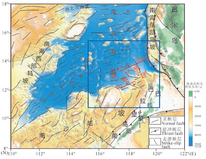
图 1 研究区位置(蓝框范围)及区域地质简图(底图为晕渲地形图,据杨胜雄等,2015)
Figure 1.
图 2 南海海盆东南部地震相及中中新统块体流沉积放大解译图(剖面位置见图 1)
Figure 2.
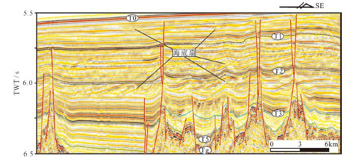
图 3 晚中新世以来海底扇沉积体发育特征(剖面位置见图 1)
Figure 3.
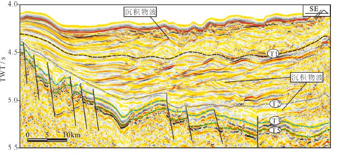
图 5 晚中新世以来西侧沉积物波沉积体发育特征(剖面位置见图 1)
Figure 5.
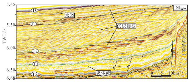
图 6 上新世以来东侧沉积物波地震相特征(剖面位置见图 1)
Figure 6.
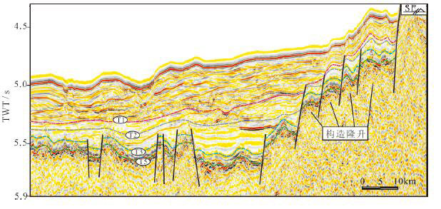
图 10 构造隆升对浊积体发育的控制(剖面位置见图 1)
Figure 10.
图 11 构造挠曲和岩浆作用对浊积体发育的控制(剖面位置见图 1)
Figure 11.
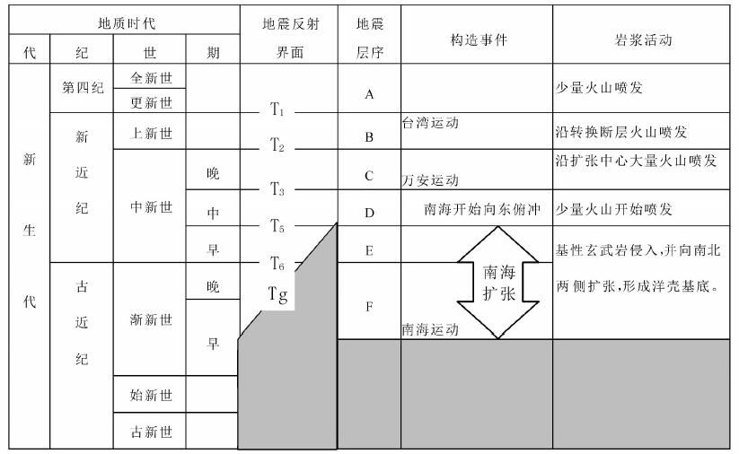
表 1 南海海盆区地震反射界面和地震层序划分
Table 1. Seismic reflection interface and seismic sequence of sea basin of South China Sea
-
Anthony E J, Julian M. 1999. Source- to- sink sediment transfers, environmental engineering and hazard mitigation in the steep Var River catchment, French Riviera, southeastern France[J]. Geomorphology, 31(1): 337-354. https://www.sciencedirect.com/science/article/pii/S1367912017303735
Briais A, Patriat P, Tapponnier P. 1993. Updated interpretation of magnetic anomalies and seafloor spreading stages in the South China Sea: Implications for the Tertiary tectonics of Southeast Asia[J]. J. Geophys. Res., 98(B4): 6299-6328. doi: 10.1029/92JB02280
Cai Guanqiang, Li Shun, Zhao Li, Gao Hongfang, Zhong Hexian. 2018. Geochemical characteristics of surface sediments from the middle deep-sea basin of South China Sea[J]. Marine Geology and Quaternary Geology, 39(4): 23- 33(in Chinese with English abstract). http://www.wanfangdata.com.cn/details/detail.do?_type=perio&id=hydzydsjdz201805009
Expedition 349 Scientists. 2014. South China Sea tectonics: Opening of the South China Sea and its implications for southeast Asian tectonis, climates, and deep mantle processes since the Late Mesozoic[R]. International Ocean Discovery Program Preliminary Report, 349. http://dx.doi.org/10.14379/iodp.pr.349.2014.
Lei Zhenyu, Zhang Li, Su Ming, Luo Shuaibing, Qian Xing, Zhang Boda. 2019. Types, characteristics and implication for hydrocarbon exploration of the Middle Miocene deep- water sediments in Beikang Basin, southern South China Sea[J]. China Geology, 2(1): 85-93. doi: 10.31035/cg2018094
Li C F, Xu X, Lin J, Sun Z, Zhu J, Yao Y, Zhao X, Liu Q S, Kulhanek D K, Wang J, Song T R, Zhao J F, Qiu N, Guan Y X, Zhou Z Y, Williams T, Bao R, Briais A, Brown E A, Chen Y F, Clift P D, Colwell F S, Dadd K A, Ding W W, Almeida I H, Huang X, Hyun S, Jiang T, Koppers A A P, Li Q Y, Liu C L, Liu Z F, Nagai R H, Peleoalampay A, Su X, Tejada M L G, Trinh H S, Yeh Y C, Zhang C L, Zhang F, Zhang G L. 2014. Ages and magnetic structures of the South China Sea constrained by deep tow magnetic surveys and IODP Expedition 349[J]. Geochem. Geophys. Geosyst., 15(12):4958-4983. doi: 10.1002/2014GC005567
Li Mengjun, Bi Naishuang, Hu Lisha, Liu Xiaohang, Xu Jingping. 2018. Sedimentary characteristics and processes revealed by the push cores of the 140th dive of DSV"Jiaolong"in the Taiwan Submarine Canyon, Northern South China Sea[J]. Marine Geology and Quaternary Geology, 39(4): 23 − 33(in Chinese with English abstract). http://www.wanfangdata.com.cn/details/detail.do?_type=perio&id=hydzydsjdz201904003
Li Ruimin, Yin Zhiqiang, Wang Yi, Li Xiaolei, Liu Qiong, Gao Mengmeng. 2018. Geological resources and environmental carrying capacity evaluation review, theory and practice in China[J]. China Geology, 1(4): 556-565. doi: 10.31035/cg2018050
Li Yangchun, Zhang Kexin, He Weihong, Xu Yadong, Song Bowen, Yu Yang, Ke Xue, Kou Xiaohu, Luo Mansheng, Xin Houtian, Fu Junyu, Yang Zhuliang, Zhao Xiaoming, Yin Fuguang, Li Zhipei. 2018. Division of tectonic-strata superregions in China[J]. China Geology, l(2): 236-256. https://www.sciencedirect.com/science/article/pii/S2096519219300308
Lin Changsong, Xia Qinglong, Shi Hesheng, Zhou Xinhuai. 2015. Geomorphological evolution, source to sink system and basin analysis[J]. Earth Science Frontiers, 22(1): 9-20(in Chinese with English abstract). http://www.wanfangdata.com.cn/details/detail.do?_type=perio&id=dxqy201501002
Lin Changsong, Liu Jingyan, Cai Shixiang, Zhang Yanmei, Lü Ming, Li Jie. 2001. Sedimentation and evolution background of large incised channel and submarine gravity flow system in Yingqiong basin[J]. Chinese Science Bulletin, 46(1): 69-72 (in Chinese with English abstract). doi: 10.1007/BF03183213
Liang Jinqiang, Deng Wei, Lu Jingan, Kuang Zenggui, He Yulin, Zhang Wei, Gong Yuehua, Liang Jin, Meng Miaomiao. 2020. A fast identification method based on the typical geophysical differences between submarine shallow carbonates and hydrate bearing sediments in the northern South China Sea[J]. China Geology, 3(1): 16-27. doi: 10.31035/cg2020021
Liu Rui, Zhou Jiangyu, Zhang Li, Liu Xiaofeng, Wei Zhenquan, Qian Xing, Shuai Qingwei, Liao Jinfang. 2013. Depositional architecture and evolution of deep water fan system in the northwestern Subbasin, South China Sea[J]. Acta Sedimentologica Sinica, 31(4): 706-716(in Chinese with English abstract). https://www.sciencedirect.com/science/article/pii/S0025322707002228
Moore G T. 1969. Interaction of rivers and oceans: Pleistocene petroleum potential[J]. AAPG Bulletin, 53(12): 2421-2430. https://www.sciencedirect.com/science/article/pii/S1068797109000455
Pang Xiong, Peng Dajun, Chen Changmin, Zhu Ming, He Min, Shen Jun, Liu Baojun. 2007. Three hierarchies"Source-Conduit-Sink" coupling analysis of the Pearl River deep- water fan system[J]. Acta Geologica Sinica, 81(6): 857- 864(in Chinese with English abstract). http://www.wanfangdata.com.cn/details/detail.do?_type=perio&id=dizhixb200706016
Peng Dajun, Pang Xiong, Chen Changmin, Zhu ming, Huang Xianlv, Shu Yu. 2006. The characteristics and controlling factors for the formation of deep-water fan system in South China Sea[J]. Acta Sedimentologica Sinica, 24(1): 10- 19(in Chinese with English abstract). https://www.sciencedirect.com/science/article/pii/S2468256X17300214
Peng Yongmin, Song Chuanchun, Wang Dengwen, Luo Qun, Huang Handong. 2011. Turbidity fans and hydrocarbon prospecting of lower 3rd Member of Shahejie Formation from well Che15, Jiyang depression[J]. Geology in China, 38(5): 1289- 1297(in Chinese with English abstract). http://www.wanfangdata.com.cn/details/detail.do?_type=perio&id=zgdizhi201105016
Qin Xuwen, Zhao Bin, Li Fuyuan, Zhang Baojin, Wang Houjin, Zhang Ruwei, He Jiaxiong, Chen Xi. 2019. Deep structural research of the South China Sea: Progresses and directions[J]. China Geology, 2 (4): 530-540. https://www.sciencedirect.com/science/article/pii/S0040195116001190
Reading H G, Richards M. 1994. Turbidite systems in deep- water basin margins classified by grain-size and feeder system[J]. AAPG Bulletin, 78(5): 792-822. http://archives.datapages.com/data/bulletns/1994-96/data/pg/0078/0005/0750/0792.htm
Shanmugam G. 2000. 50 years of the turbidite paradigm (1950s1990s): deep- water processes and facies models: A critical perspective[J]. Marine and Petroleum Geology, 17(2): 285-342. doi: 10.1016/S0264-8172(99)00011-2
Shanmugam G. 2006. Deep- water Processes and Facies Models: Implications for Sandstone Petroleum Reservoirs[M]. Elsevier Science, 191-236.
Sømme T O, Jackson C A L, Vaksdal M. 2013. Source- to- sink analysis of ancient sedimentary systems using a subsurface case study from the Mør-Trøndelag area of southern Norway: Part 1depositional setting and fan evolution[J]. Basin Research, 25(5): 489-511. doi: 10.1111/bre.12013
Stow D A V, Johansson M. 2000. Deep-water massive sands: nature, origin and hydrocarbon implications[J]. Marine and Petroleum Geology, 17(2): 145-174. doi: 10.1016/S0264-8172(99)00051-3
Su Ming, Zhang Cheng, Xie Xinong, Wang Zhenfeng, Jiang Tao, He Yunlong, Zhang Cuimei. 2000. Controlling factors on the submarine canyon system: A case study of the Central Canyon System in the Qiongdongnan Basin, northern South China Sea[J]. Science China: Earth Sciences, 44(8): 1807-1820(in Chinese with English abstract). https://link.springer.com/article/10.1007/s11430-014-4878-4
Wang Hairong, Wang Yingmin, Qiu Yan, Peng Xuechao, Li Wencheng. 2008. Development and its tectonic activity´s origin of turbidity current sediment wave in Taiwan bank, northeastern South China Sea[J]. Acta Sedimentologica Sinica, 26(1): 39−45(in Chinese with English abstract).
Wang Yahui, Zhang Daojun, Zhao Pengxiao, Chen Yang, Huang Can, Su Yufeng. 2016. A new consideration on the genetic mechanism of the central canyon in the Qiongdongnan Basin, the northern South China Sea[J]. Acta Oceanologica Sinica, 38(11): 97- 124(in Chinese with English abstract). http://www.wanfangdata.com.cn/details/detail.do?_type=perio&id=hyxb201611009
Xu Shumei, Peng W U, Zhang Wei, Zhang Haiyang, Liu Zhi, Dai Liming, Li Jianwei, Li Lingbo. 2013. Paleo-coastline changes in South China Sea in some critical times[J]. Marine Geology and Quaternary Geology, 33(1): 1-10(in Chinese with English abstract). http://www.wanfangdata.com.cn/details/detail.do?_type=perio&id=hydzydsjdz201301001
Yang Shengxiong, Qiu Yan, Zhu Benduo. 2015. Atlas of Geology and Geophysics of South China Sea(1:2000000)[M]. Tianjing: China Navigation Publications (in Chinese with English abstract).
Yao Bochu, Wang Ling, Wu Nengyou. 2004. Cenozoic plate tectonic activities in the Great South China Sea area[J]. Geology in China, 31(2):113-122(in Chinese with English abstract). http://www.wanfangdata.com.cn/details/detail.do?_type=perio&id=zgdizhi200402001
Zhong Guangjian, Wu Nengyou, Lin Zhen, Yao Yongjian, Yi Hai.2008. Characteristics of faults on the northeastern continental slope of the South China Sea and their controls on basin evolution[J]. Geology in China, 35(3): 456- 462 (in Chinese with English abstract). http://www.wanfangdata.com.cn/details/detail.do?_type=perio&id=zgdizhi200803009
蔡观强, 李顺, 赵利, 高红芳, 钟和贤. 2018.南海海盆中部表层沉积物地球化学特征[J].海洋地质与第四纪地质, 38(5): 90−101. http://www.wanfangdata.com.cn/details/detail.do?_type=perio&id=hydzydsjdz201805009
李梦君, 毕乃双, 胡丽沙, 刘晓航, 徐景平. 2018.南海北部台湾峡谷"蛟龙号"第140潜次沉积物特征及其沉积过程指示意义[J].海洋地质与第四纪地质, 39(4): 23−33. http://www.wanfangdata.com.cn/details/detail.do?_type=perio&id=hydzydsjdz201904003
林畅松, 刘景彦, 蔡世祥, 张艳梅, 吕明, 李杰. 2001.莺琼盆地大型下切谷和海底重力流体系的沉积构成和发育背景[J].科学通报, 46(1): 69−72. http://www.wanfangdata.com.cn/details/detail.do?_type=perio&id=kxtb200101018
林畅松, 夏庆龙, 施和生, 周心怀. 2015.地貌演化、源-汇过程与盆地分析[J].地学前缘, 22(1): 9−20. doi: 10.13745/j.esf.2015.01.002
刘睿, 周江羽, 张莉, 刘小峰, 韦振权, 钱星, 帅庆伟, 廖锦芳. 2013.南海西北次海盆深水扇系统沉积演化特征[J].沉积学报, 31(4): 706−716. http://www.wanfangdata.com.cn/details/detail.do?_type=perio&id=cjxb201304018
庞雄, 彭大钧, 陈长民, 朱明, 何敏, 申俊, 柳保军. 2007.三级"源-渠-汇"耦合研究珠江深水扇系统[J].地质学报, 81(6): 857−864. http://www.wanfangdata.com.cn/details/detail.do?_type=perio&id=dizhixb200706016
彭大均, 庞雄, 陈长民, 朱明, 黄先律, 舒誉.2006.南海珠江深水扇系统的形成特征与控制因素[J].沉积学报, 24 (1): 10−19. http://www.wanfangdata.com.cn/details/detail.do?_type=perio&id=cjxb200601002
彭勇民, 宋传春, 王登稳, 罗群, 黄捍东. 2011.济阳坳陷车15井区浊积扇沉积及油气勘探意义[J].中国地质, 38(5): 1289−1297. http://www.wanfangdata.com.cn/details/detail.do?_type=perio&id=zgdizhi201105016
苏明, 张成, 解习农, 王振峰, 姜涛, 何云龙, 张翠梅. 2014.深水峡谷体系控制因素分析——以南海北部琼东南盆地中央峡谷体系为例[J].中国科学:地球科学, 44(8): 1807−1820. http://www.wanfangdata.com.cn/details/detail.do?_type=perio&id=zgkx-cd201408018
王海荣, 王英民, 邱燕, 彭学超, 李文成. 2008.南海东北部台湾浅滩陆坡的浊流沉积物波的发育及其成因的构造控制[J].沉积学报, 26(1): 39−45. http://www.wanfangdata.com.cn/details/detail.do?_type=perio&id=cjxb200801005
王亚辉, 张道军, 赵鹏肖, 陈扬, 黄灿, 苏榆丰. 2016.南海北部琼东南盆地中央峡谷成因新认识[J].海洋学报, 38(11): 97−124. http://www.wanfangdata.com.cn/details/detail.do?_type=perio&id=hyxb201611009
许淑梅, 吴鹏, 张威, 张海洋, 刘智, 戴黎明, 李健伟, 李灵波. 2013.南海关键地质历史时期的古海岸线变化[J].海洋地质与第四纪地质, 33(1): 1−10. http://www.wanfangdata.com.cn/details/detail.do?_type=perio&id=hydzydsjdz201301001
杨胜雄, 邱燕, 朱本铎. 2015.南海地质地球物理图系(1:2000000)[M].天津:中国航海图书出版社.
姚伯初, 万玲, 吴能有. 2004.大南海地区新生代板块构造活动[J].中国地质, 31(2): 113−122. http://www.wanfangdata.com.cn/details/detail.do?_type=perio&id=zgdizhi200402001
钟广见, 吴能有, 林珍, 姚永坚, 易海. 2008.南海东北部断裂特征及其对盆地演化的控制作用[J].中国地质, 35(3): 456−462.
期刊类型引用(4)
1. 程琳燕,李磊,高毅凡,张威,龚广传,杨志鹏,王潘. 琼东南盆地陵水凹陷海底周期阶坎底形的特征及成因. 海洋地质与第四纪地质. 2022(01): 37-44 . 百度学术
2. 赵斌,王利杰,张宝金,耿明会,秦绪文,张如伟,杨振,陈玺,吕文超,张旭东. 南海东部次海盆南侧基底结构与沉积特征及其控制因素. 大地构造与成矿学. 2022(05): 884-897 . 百度学术
3. 刘建平,鲜本忠,张莉,苏明,李宇志,闫海清,王震,陈鹏,吴千然,李晋,田荣恒,杨鑫,周欢焕,罗勋,陈龙. 渤海湾盆地东营凹陷碎屑流主控型深水体系沉积过程及模式. 中国地质. 2022(06): 1951-1969 . 本站查看
4. 李法坤,戴黎明,杜晓东,蔡国富,李三忠,董昊,王宇. 构造-沉积耦合过程的数值模拟:以南海北部阳江凹陷为例. 海洋地质与第四纪地质. 2021(05): 139-150 . 百度学术
其他类型引用(0)
-