

Requirements of Map Compilation and Database Building of 1∶50 000 Mineral Geological Maps
-
摘要:
1∶50 000固体矿产地质调查是保障国家能源资源安全的长期的基础性、公益性、战略性地质工作,是矿产勘查的重要基础和先导性工作,是国家地质调查与地球系统科学研究程度的重要指标,目的是摸清国家矿产资源家底、实现重大找矿突破或新发现、引导和拉动后续矿产勘查,在服务国家重大战略、社会发展和生态文明建设中发挥着重要的作用。2019年中国地质调查局正式印发《固体矿产地质调查技术要求(1∶50 000)》(DD2019–02),创建了以成矿作用类型为主线、以成矿要素为对象、以预研究为基础、以矿产地质专项填图为核心、按成矿作用类型填(编)建造构造图的新方式和基于矿床模型综合地质信息预测方法的矿产资源潜力评价技术体系,建立了地质潜力、技术经济可行性和环境影响“三位一体”综合评价工作体系,为固体矿产地质调查及其成果表达指明方向,为支撑固体矿产勘查提供技术保障。其中1∶50 000矿产地质图是固体矿产地质调查核心成果图件,在此结合技术要求简要阐述1∶50 000矿产地质图编制与数据库建设要求。
Abstract:1∶50 000 solid mineral geological surveys are long-term basic, public-spirited, and strategic geological work that guarantee national energy and resource security. They serve as both an important foundation and forerunner of mineral exploration and an important index of national geological surveys and earth system science research. Their purpose is to ascertain national mineral reserves, achieve significant breakthroughs in prospecting or make new discoveries, and guide and drive subsequent mineral exploration. Meanwhile, they play an important role in serving major strategies, social development, and ecological civilization construction. In 2019, the China Geological Survey officially issued the Technical Requirement of1∶50 000Solid Mineral Geological Survey (DD 2019-02), creating a new mineral geological survey method by mapping (compiling) suite-tectonic maps according to mineralization types and taking mineralization types as the thread, metallogenic factors as the objects, pre-research as the base, and mineral and geology-specific mapping as the core. Meanwhile, a mineral resources potential evaluation technical system and a "trinity" assessment system were also established. The former is based on the comprehensive geological information prediction of deposit models and the later integrates the assessment of geological potential, technical and economic feasibility, and environmental impact. All these guide solid mineral geological surveys and the expression of survey results and provide technical support for solid mineral exploration. Among them, the 1∶50 000 mineral geological maps serve as the core result maps of solid mineral geological surveys. This paper focuses on a brief description of the requirements of map compilation and database building of 1∶50 000 mineral geological maps based on the Technical Requirement of1∶50 000 Solid Mineral Geological Survey (DD 2019-02).
-

-
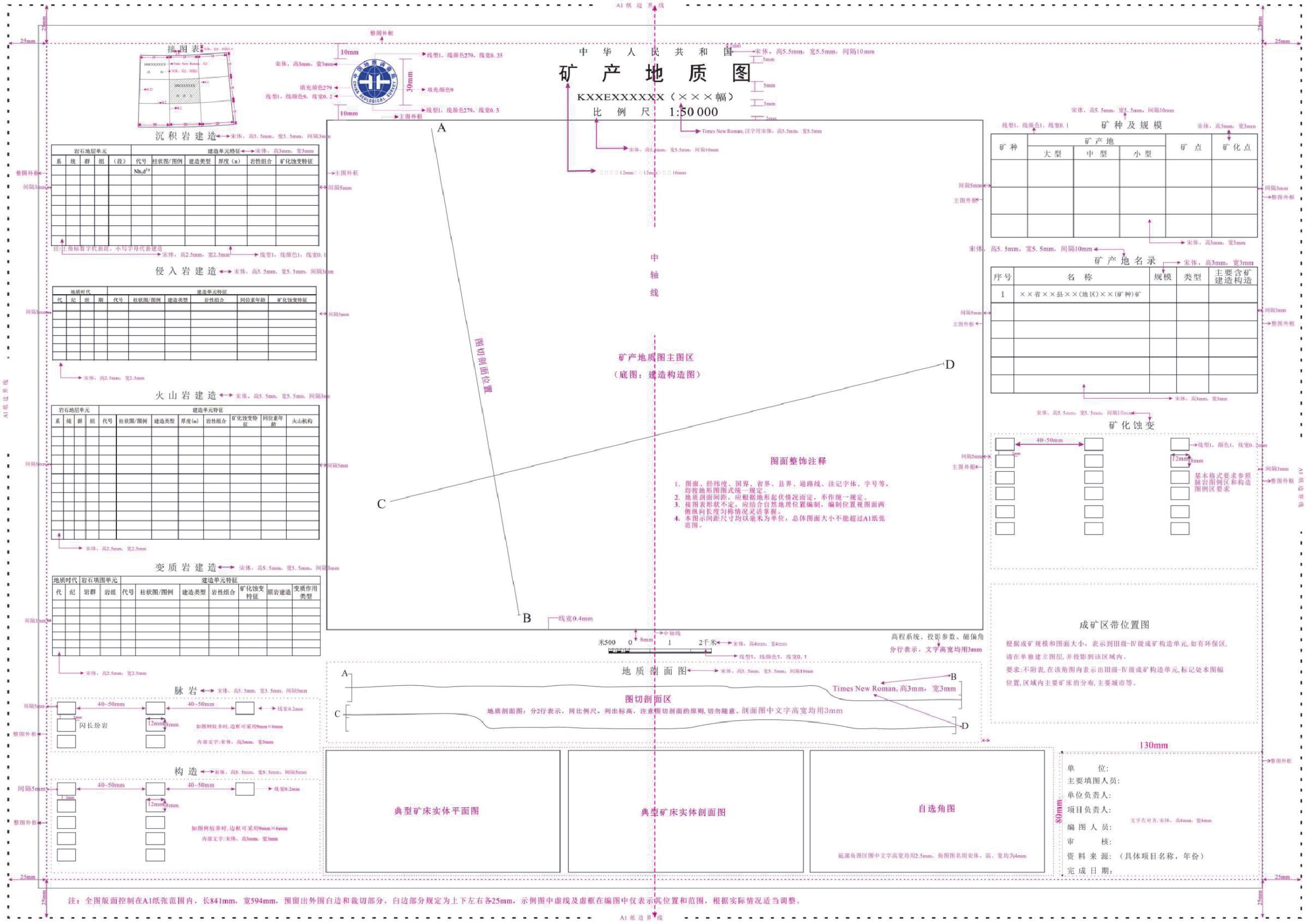
表 1 图层信息表
图层编号
及名称具体图层名称 空间特性 数据表 备注 1 地理
图层主要行政境界图层 线 无 直接引用数字填图背景图层 主要居民点地图层 点 无 主要面状水系图层 面 无 主要线状水系图层 线 无 主要地理标注图层 点 无 2 建造构造图层 建造构造图层 面 有 根据地质体面实体(_GeoPolygon.wp)编制 地质(界)线 线 有 根据地质(界)线(_GeoLine.wl)编制 构造变形带图层 面 有 根据(_TECOZONE.wp)编制 褶皱图层 线 有 本次新增(_FOLD.wt) 断裂图层 线 有 由地质界线中提取后,根据_FAULT挂接属性 产状要素图层 点 有 引用_ATTITUDE.wt图层 重要钻孔图层 点 有 引用_DRILLHOLE.wt图层 化石样点图层 点 有 引用_FOSSIL.wt图层 同位素年龄图层 点 有 引用_ISOTOPE.wt图层 3 矿产地图层 点 有 引用_MINERAL_PNT.wt图层 4 整饰
图层主图
内部分地质注记与建造花纹 点 无 根据a_GEOPOLYGON.wt
图层编制建造花纹指引线 线 无 a_GEOPOLYGON.wl 断层倾向、倾角及断层性质 点 无 a_GEOLINE.wt 产状倾角 点 无 a_ATTITUDE.wt 同位素注记 点 无 a_ISOTOPE.wt 图切剖面 线、点 无 a_PROFILE.wl
a_PROFILE.wt方里网 线 无 FRAME.wl 主图
外部分接图表 点、线、面 无 MAP_SHEET.wt
MAP_SHEET.wl
MAP_SHEET.wp图例 点、线、面 无 LEGEND.wt
LEGEND.wl
LEGEND.wp建造柱状图 点、线、面 无 COLUMNAR_SECTION.wt
COLUMNAR_SECTION.wl
COLUMNAR_SECTION.wp图切剖面 点、线、面 无 CUTTING_PROFILE.wt
CUTTING_PROFILE.wl
CUTTING_PROFILE.wp典型矿区
图件点、线、面 无 TYPICALDEPOSITS.wt
TYPICALDEPOSITS.wl
TYPICALDEPOSITS.wp责任表 点 无 DUTY_TABLE.wt 图外其他
整饰点、线、面 无 图名、比例尺、方里网注记、局徽及其他
OTHERMODIFY.wt
OTHERMODIFY.wl
OTHERMODIFY.wp 下载: 导出CSV
表 2 建造构造图层数据表
数据项名称 标准编码 数据
类型数据存储长度 数据显示长度 约束
条件默认值/初始值 值域范围 数据项描述 地质体面实体标识号 *Feature_Id Character 20 NOTNULL 引用地质体面实体(_GEOPOLYGON.wp)属性
内容原编码 Source_Id Character 30 O 地质体面实体类型代码(地质代码) *Feature_Type Character 30 M 地质体面实体名称 Geobody_Name Character 50 M 地质体面实体时代 Geobody_Era Character 20 M 建造大类 Formation Character 10 M 填写沉积岩建造、侵入岩建造、火山岩建造、变质岩建造等大类(汉字名称) 建造类型 Metallogenic Character 60 M 填写与建造大类相对应的建造类型(汉字名称) 岩石组合 Combination Character 100 M 填写岩石自然共生组合(汉字名称) 大地构造环境 Structural_Env Character 100 M 填写所处大地构造单元名称(汉字名称) 地质体面实体下限年龄值 Geobody_Age1 Double 10.2 O 引用地质体面
实体(_GEOPOLYGON.wp)属性内容地质体面实体上限年龄值 Geobody_Age2 Double 10.2 O 子类型标识 Subtype Integer 4 O
下载: 导出CSV
表 3 地质界线图层数据表
数据项名称 标准编码 数据
类型数据存储长度 数据显示长度 约束
条件默认值/初始值 值域范围 数据项描述 要素标识号 *Feature_Id Character 20 NOTNULL 引用地质(界)线(_GeoLine.wl)属性内容 原编码 Source_Id Character 30 O 地质界线(接触)代码 *Feature_Type Character 30 M 地质界线类型 Boundary_Name Character 50 M 界线左侧地质体代号 Left_Boundary_Code Character 30 M 界线右侧地质体代号 Right_Boundary_Code Character 30 M 界面走向 Strike Integer 3 O 界面倾向 Dip_Direction Integer 3 O 界面倾角 Dip_Angle Integer 2 O 子类型标识 Subtype Integer 4 O
下载: 导出CSV
表 4 构造变形带图层数据表
数据项名称 标准编码 数据
类型数据存储长度 数据显示长度 约束
条件默认值/初始值 值域范围 数据项描述 要素标识号 *Feature_Id Character 20 NOTNULL 引用(_TECOZO
NE.wp)属性内容原编码 Source_Id Character 30 O 变形带代码 *Feature_Type Character 30 M 变形带类型
名称Deformation_Name Character 60 M 变形带岩石
名称Defor_Rockname Character 60 M 变形带组构
特征Fabric_Character Character 250 M 变形力学特征 Mechanics Character 250 M 形成时代 Ear Character 100 M 活动期次 Movement_Period Character 200 M 含矿性 Commodities Character 120 O 子类型标识 Subtype Integer 4 O
下载: 导出CSV
表 5 断裂图层数据表
数据项名称 标准编码 数据
类型数据存储长度 数据显示长度 约束
条件默认值/初始值 值域范围 数据项描述 要素分类
代码*Feature_Type Character 30 NOTNULL 引用_FAULT数据表属性
内容断层类型(地质代码) Fault_Type Character 30 M 断层名称 Fault_Name Character 80 M 断层编号 Fault_Code Character 30 M 断层性质 Fault_Character Character 250 M 断层上盘地质体代号 Fault_Up_Body Character 30 M 断层下盘地质体代号 Fault_Bottom_Body Character 30 M 断层破碎带宽度 Fault_Wide Character 80 O 断层走向 Fault_Strike Integer 3 O 断层倾向 Fault_Dip Integer 3 O 断层面倾角 Fault_Dip_Angle Integer 2 O 估计断距 Fault_Distance Float 10.2 M 断层形成
时代Era Character 30 O 活动期次 Movement_Period Character 100 O 子类型标识 Subtype Integer 4 O
下载: 导出CSV
表 6 褶皱图层数据表
序号 数据项名称 数据项
代码数据类型 存储长度 小数位数 约束条件 默认值/初始值 值域 值单位 数据项填写规定 数据项词语定义或描述(即数据项词条定义或描述) 1 图元编号 CHFCAC C 6 NOTNULL 按十进制数字码、从“000001”开始顺序
填写图元编号是空间数据库(未汇总的)连结图形与属性的关键字,在两者中必须保持一致,按顺序码编写,主要省级用 2 褶皱名称 GZCAB C 40 O 填写通用的褶皱名称 填写图幅内褶皱的汉字名称 3 褶皱类型 GZCE C 20 M 填写褶皱
类型根据褶皱形态将褶皱大致划分为背斜(背形)、向斜(向形)、倒转褶皱、平卧褶皱和倾竖褶皱等褶皱类型(源自潜力评价数据项下属词分册GZCE) 4 褶皱形态 GZCDD C 20 O 填写褶皱
形态填写长轴、短轴、卵形等褶皱形态(源自潜力评价数据项下属词分册GZCD) 5 枢纽倾伏向 GZCCBE C 7 O 度 填写褶皱枢纽的倾伏向 6 枢纽倾伏角 GZCCBF C 5 O 度 填写褶皱枢纽的倾伏角 7 轴面倾向 GZCCAE C 7 O 度 填写褶皱轴面的倾向 8 轴面倾角 GZCCAF C 5 O 度 填写褶皱轴面的倾角 9 卷入褶皱的地层 GZCFA C 20 O 填写地层的时代、岩性和变质程度 10 形成时代 GZEKG C 15 M 填写褶皱形成年代 根据卷入地层及与其他构造的关系判断褶皱的形成时间
下载: 导出CSV
表 7 化石采样点图层数据表
数据项名称 标准编码 数据
类型数据存储长度 数据显示长度 约束条件 默认值/初始值 值域范围 数据项描述 要素标识号 *Feature_Id Character 20 NOTNULL 引用_FOSSIL.wt图层属性内容 原编码 Source_Id Character 30 O 化石样品编号 Sample_Code Character 20 O 化石所属生物门类 *Feature_Type Character 50 M 化石属或种名 Genus_Species Character 50 M 化石产出层位 Bed Character 50 M 含化石地层单位代号 Lithostrat_Unit Character 20 M 化石时代 Era Character 40 M 子类型标识 Subtype Integer 4 O
下载: 导出CSV
表 8 同位素年龄图层数据表
数据项名称 标准编码 数据
类型数据存储长度 数据显示长度 约束
条件默认值/初始值 值域范围 数据项描述 要素标识号 *Feature_Id Character 20 NOTNULL 引用_ISOTOPE.wt图层属性内容 原编码 Source_Id Character 30 O 样品编号 Sample_Code Character 30 M 样品名称 Sample_Name Character 50 M 年龄测定方法 Measuring_Kinds Character 60 M 测定年龄 Age Character 100 M 被测定出地质体单位及代号 Geobody_Code Character 30 M 测定分析单位 Unit Character 50 M 测定分析日期 Date Character 8 YYYYMMDD 子类型标识 Subtype Integer 4 O
下载: 导出CSV
表 9 产状要素图层数据表
数据项名称 标准编码 数据
类型数据存储长度 数据显示长度 约束
条件默认值/初始值 值域范围 数据项描述 要素标识号 *Feature_Id Character 20 NOTNULL 引用_ATTITUDE.wt属性内容 原编码 Source_Id Character 30 O 产状类型名称代码 *Feature_Type Character 30 M 产状类型名称 Attitude_Name Character 40 M 走向 Strike Integer 3 M 倾向 Dip_Direction Integer 3 M 倾角 Dip_Angle Integer 2 M 子类型标识 Subtype Integer 4 O
下载: 导出CSV
表 10 重要钻孔图层数据表
数据项名称 标准编码 数据
类型数据存储长度 数据显示长度 约束
条件默认值/初始值 值域范围 数据项描述 要素标识号 *Feature_Id Character 20 NOTNULL 引用(_Drillhole)图层属性内容 原编码 Source_Id Character 30 O 钻孔编号 Zk_Code Character 30 M 钻孔深度 Zk_Depth Float 10.2 M 基岩或目的层孔深 Rock_Depth Float 10.2 M 基岩或目的层岩性 Rock_Type Character 200 O 基岩或目的层时代 Base_Bed_Era Character 50 O 松散沉积层的年代 Loose_Lay_Era Character 30 O 松散沉积层的分层厚度 Loose_Lay_
ThicknessFloat 10.2 O 松散沉积层的岩性 Loose_Lay_
LithologyCharacter 255 O 子类型标识 Subtype Integer 4 O 主键名称Feature_Id,Zk_Code
索引键名称Zk_Code
下载: 导出CSV
表 11 矿产地图层数据表
数据项名称 标准编码 数据
类型数据存储长度 数据显示长度 约束
条件默认值/初始值 值域范围 数据项描述 要素标识号 *Feature_Id Character 20 NOTNULL 引用_MINERAL_PNT.WT图层属性内容 原编码 Source_Id Character 30 O 矿种代码 *Feature_Type Character 50 M 矿种名称 Commodities_
NameCharacter 60 M 共生矿 Paragenic_Ore Character 100 M 伴生矿 Associated_Ore Character 80 M 矿产地数 Ore_Sums Integer 3 O 矿石品位 Ore_Grade Character 100 M 规模 Deposite_Size Character 100 M 成矿时代 Metallogenetic_
EpochCharacter 30 M 矿产地名 Placename Character 60 M 矿化类型 Genesis_Types Character 200 O 成因类型 Industrial_Types Character 200 O 子类型标识 1 SUBTYPE Integer 4 O
下载: 导出CSV
Table 1. Data table of map layer information
Map layer no.
and nameSpecific map
layer nameSpatial characteristics Data
tableRemarks 1 Geographic map layer Map layer of major administrative boundaries/borders Line None Directly referring to the background layer of the digital mapping system Map layer of major residential areas Point None Map layer of major planar streams Polygon None Map layer of major linear streams Line None Map layer of major geographical annotations Point None 2 Suite-tectonic map layer Suite-tectonic map layer Polygon Available Prepared based on geological polygon entity file (_GeoPolygon.wp) Geological (boundary) line Line Available Prepared based on geological line entity file (_GeoLine.wl) Tectonic deformation zone map layer Polygon Available Prepared based on (_TECOZONE.wp) Fold map layer Line Available (_FOLD.wt) is newly added Fault map layer Line Available Correlating attributes according to _FAULT after extracting faults from geological boundaries Attitude element map layer Point Available Referring to the map layer _ATTITUDE.wt Map layer of important boreholes Point Available Referring to the map layer _DRILLHOLE.wt Fossil sampling point layer Point Available Referring to the map layer _FOSSIL.wt Isotopic age layer Point Available Referring to the map layer _ISOTOPE.wt 3 Mineral map layer Point Available Referring to the map layer _MINERAL_PNT.wt 4 Decoration map layer Decorations inside the master map Geological annotation and suite pattern Point None Compiling formation patterns based on a_GEOPOLYGON.wt layer Leader line Line None a_GEOPOLYGON.wl Dip, dip angle, and property of a fault Point None a_GEOLINE.wt Dip angle of occurrence Point None a_ATTITUDE.wt Isotope annotation Point None a_ISOTOPE.wt Cross-section Line and point None a_PROFILE.wl
a_PROFILE.wtKilometer grid Line None FRAME.wl Decorations outside the master map Index map Point, line, and polygon None MAP_SHEET.wt
MAP_SHEET.wl
MAP_SHEET.wpLegend Point, line, and polygon None LEGEND.wt
LEGEND.wl
LEGEND.wpSuite histogram Point, line, and polygon None COLUMNAR_SECTION.wt
COLUMNAR_SECTION.wl
COLUMNAR_SECTION.wpCross-section Point, line, and polygon None CUTTING_PROFILE.wt
CUTTING_PROFILE.wl
CUTTING_PROFILE.wpTypical mining area map Point, line, and polygon None TYPICALDEPOSITS.wt
TYPICALDEPOSITS.wl
TYPICALDEPOSITS.wpDuty table Points None DUTY_TABLE.wt Others Point, line, and polygon None Map title, scale, kilometer grid annotation, logo of the China Geological Survey, etc.
OTHERMODIFY.wt
OTHERMODIFY.wl
OTHERMODIFY.wp
下载: 导出CSV
Table 2. Data table of suite-tectonic map layer
Data item Standard code Data type Storage length Display length Constraint Default value/initial value Value
rangeDescription ID of a geological polygon entity *Feature_Id Character 20 NOTNULL Referring to the attributes of geological polygon entities (_GEOPOLYGON.wp) Original ID Source_Id Character 30 0 Type code of a geological polygon entity (geological code) *Feature_Type Character 30 M Name of a geological polygon entity Geobody_Name Character 50 M Era of a geological polygon entity Geobody_Era Character 20 M Suite category Formation Character 10 M Filling in suite categories such as sedimentary rock suite, intrusive rock suite, volcanic rock suite, or metamorphic rock suite (in Chinese characters) Suite type Metallogenic Character 60 M Filling in the suite type corresponding to the suite category (name in Chinese) Lithologic association Combination Character 100 M Filling in natural paragenetic associations of rocks (name in Chinese) Geotectonic environment Structural_Env Character 100 M Filling in the name of the geotectonic unit (name in Chinese) Lower age limit of a geological polygon entity Geobody_Age1 Double 10.2 O Referring to the attributes of geological polygon entities (_GEOPOLYGON.wp) Upper age limit of a geological polygon entity Geobody_Age2 Double 10.2 O Subtype ID Subtype Integer 4 O
下载: 导出CSV
Table 3. Data table of geological boundary map layer
Data item Standard code Data type Storage length Display length Constraint Default value/Initial value Value range Description Feature ID *Feature_Id Character 20 NOTNULL Referring to the attributes of geological (boundaries) lines (_GeoLine.wl) Original ID Source_Id Character 30 O Geological boundary (contact) code *Feature_Type Character 30 M Geological boundary type Boundary_Name Character 50 M Code of the geologic block on the left side of a boundary Left_Boundary_Code Character 30 M Code of the geologic block on the right side of a boundary Right_Boundary_Code Character 30 M Interface strike Strike Integer 3 O Interface dip Dip_Direction Integer 3 O Interface dip angle Dip_Angle Integer 2 O Subtype ID Subtype Integer 4 O
下载: 导出CSV
Table 4. Data table of structural deformation zone map layer
Data item Standard code Data type Storage
lengthDisplay
lengthConstraint Default value/Initial value Value range Description Feature ID *Feature_Id Character 20 NOTNULL Referring to the attributes of (_TECOZONE.wp) Original ID Source_Id Character30 O Deformation zone code *Feature_Type Character 30 M Deformation zone name Deformation_Name Character 60 M Rock name of a deformation zone Defor_Rockname Character 60 M Fabric characteristics of a deformation zone Fabric_Character Character 250 M Mechanical characteristics of deformation Mechanics Character 250 M Formation era Ear Character 100 M Active stage Movement_Period Character 200 M Ore-bearing features Commodities Character 120 O Subtype ID Subtype Integer 4 O
下载: 导出CSV
Table 5. Data table of fault map layer
Data item Standard code Data type Storage
lengthDisplay
lengthConstraint Default value/Initial value Value range Description Feature type code *Feature_Type Character 30 NOTNULL Referring to the attributes of the data table _FAULT Fault type (geological code) Fault_Type Character 30 M Fault name Fault_Name Character 80 M Fault code Fault_Code Character 30 M Fault characteristics Fault_Character Character 250 M Codes of geologic blocks on the hanging wall of a fault Fault_Up_Body Character 30 M Code of geologic blocks on the foot wall of a fault Fault_Bottom_Body Character 30 M Width of a fault fracture zone Fault_Wide Character 80 O Fault strike Fault_Strike Integer 3 O Fault dip Fault_Dip Integer 3 O Fault dip angle Fault_Dip_Angle Integer 2 O Estimated fault throw Fault_Distance Float 10.2 M Formation era Era Character 30 O Active stage Movement_Period Character 100 O Subtype ID Subtype Integer 4 O
下载: 导出CSV
Table 6. Data table of fold map layer
Serial no. Date item Code Data
typeStorage length Decimal digits Constraint Default value/
initial valueValue range Unit Stipulation of filling Definition or description of data item 1 Primitive code CHFCAC C 6 NOTNULL Filling with the decimal numbers in order, starting from "000001" Primitive codes are keywords linking graphics and attributes in spatial database (not summarized). Therefore, it must be consistent between graphics and attributes and coded according to sequence codes. They are mainly used at a provincial level. 2 Fold name GZCAB C 40 O Filling in universal fold name Filling in the Chinese name of a fold in a map sheet 3 Fold type GZCE C 20 M Filling in fold type Folds are roughly classified into anticlines, synclines, inverted folds, recumbent folds, and plunging folds according to their morphology(sourced from subordinate word volume GZCE of potential evaluation data items) 4 Fold morphology GZCDD C 20 O Filling in fold morphology Filling in the fold morphology such as long axis, short axis, and ovate(sourced from subordinate word volume GZCD of potential evaluation data items) 5 Fold hinge plunge direction GZCCBE C 7 O Degree (°) Filling in the plunge direction of a fold hinge 6 Fold hinge plunge angle GZCCBF C 5 O Degree (°) Filling in the dip angle of a fold hinge 7 Axial plane dip GZCCAE C 7 O Degree (°) Filling in the dip of a fold axial plane 8 Axial plane dip angle GZCCAF C 5 O Degree (°) Filling in the dip angle of a fold axial plane 9 Strata involved in a fold GZCFA C 20 O Filling in the era, lithology, and metamorphic degree of strata 10 Formation era GZEKG C 15 M Filling formation era of a fold Judging the formation era of a fold according to the involved strata and the relationship between the involved strata and other structures
下载: 导出CSV
Table 7. Data table of fossil sampling points
Data item Standard code Data type Storage length Display length Constraint Default value/
Initial valueValue range Description Feature ID *Feature_Id Character 20 NOTNULL Referring to the attributes of _FOSSIL.wt Original code Source_Id Character 30 O Fossil sample ID Sample_Code Character 20 O Biological category *Feature_Type Character 50 M Fossil genus or species Genus_Species Character 50 M Fossil horizon Bed Character 50 M Code of fossil-bearing stratigraphic unit Lithostrat_Unit Character 20 M Fossil era Era Character 40 M Subtype ID Subtype Integer 4 O
下载: 导出CSV
Table 8. Data table of isotopic age map layer
Data item Standard code Data type Storage length Display length Constraint Default value/
Initial valueValue range Description Feature ID *Feature_Id Character 20 NOTNULL Referring to the attributes of _ISOTOPE.wt Original code Source_Id Character 30 O Sample code Sample_Code Character 30 M Sample name Sample_Name Character 50 M Dating method Measuring_Kinds Character 60 M Dated age Age Character 100 M Dated geologic block unit and code Geobody_Code Character 30 M Dating organization Unit Character 50 M Dating date Date Character 8 YYYYMMDD Subtype ID Subtype Integer 4 O
下载: 导出CSV
Table 9. Data table of attitude feature map sheet
Data item Standard code Data type Storage length Display length Constraint Default value/
Initial valueValue range Description Feature ID *Feature_Id Character 20 NOTNULL Referring to the attributes of _ATTITUDE.wt Source code Source_Id Character 30 O Attitude type code *Feature_Type Character 30 M Attitude type name Attitude_Name Character 40 M Strike Strike Integer 3 M Dip direction Dip_Direction Integer 3 M Dip angle Dip_Angle Integer 2 M Subtype ID Subtype Integer 4 O
下载: 导出CSV
Table 10. Data table of important borehole map layer
Data item Standard code Data type Storage length Display length Constraint Default value/
Initial valueValue range Description Feature ID *Feature_Id Character 20 NOTNULL Referring to the attributes of (_Drillhole) Original code Source_Id Character 30 O Borehole code Zk_Code Character 30 M Borehole depth Zk_Depth Float 10.2 M Borehole depth in bedrock or target stratum Rock_Depth Float 10.2 M Lithology of bedrock or target stratum Rock_Type Character 200 O Era of bedrock or target stratum Base_Bed_Era Character 50 O Era of loose sediment layer Loose_Lay_Era Character 30 O Thickness of loose sediments Loose_Lay_Thickness Float 10.2 O Lithology of loose sediments Loose_Lay_Lithology Character 255 O Subtype ID Subtype Integer 4 O Primary key name: Feature_Id;
Index key name: Zk_Code
下载: 导出CSV
Table 11. Data table of mineral deposit map layer
Data item Standard code Data type Storage length Display length Constraint Default value/
Initial valueValue range Description Feature ID *Feature_Id Character 20 NOTNULL Referring to the attributes of _MINERAL_PNT.WT Source code Source_Id Character 30 O Mineral type code *Feature_Type Character 50 M Mineral type name Commodities_Name Character 60 M Paragenetic ore Paragenic_Ore Character 100 M Associated ore Associated_Ore Character 80 M Mineral deposit number Ore_Sums Integer 3 O Ore grade Ore_Grade Character 100 M Deposit scale Deposite_Size Character 100 M Metallogenetic epoch Metallogenetic_Epoch Character 30 M Name of mineral deposit Placename Character 60 M Mineralization type Genesis_Types Character 200 O Genesis type Industrial_Types Character 200 O Subtype ID 1 SUBTYPE Integer 4 O
下载: 导出CSV
-
[1] DD 2006−05. 地质信息元数据标准[S].
[2] DD 2006−06. 数字地质图空间数据库标准[S].
[3] DZ/T 0179−1997.地质图用色标准及用色原则(1∶50 000)[S].
[4] GB/T 20257.3−2006. 国家基本比例尺地图图式 第3部分: 1∶25 000 1∶50 000 1∶100 000地形图图式[S].
[5] GB/T 958−2015. 区域地质图图例[S].
[6] 陈燕申, 陈思凯. 2017. 美国联邦法规采用标准的探讨与启示[J]. 标准科学, 4: 15−23. doi: 10.3969/j.issn.1674-5698.2017.01.003
[7] 陈毓川, 王登红, 陈郑辉. 2010. 重要矿产和区域成矿规律研究技术要求[M]. 北京: 地质出版社.
[8] 杜子图, 翟刚毅, 程光华. 2014. 中国基础地质调查发展战略研究[M]. 北京: 地质出版社.
[9] 何进忠, 吕传元, 曹海龙, 张祥年, 武凌, 牛鹏飞. 2020. 甘肃省巴藏幅 1∶50 000 矿产地质图数据库 [J].中国地质, 47(S2):103−118.
[10] 贾祥祥, 王树明, 贾儒雅, 夏云, 任志翔. 2020. 甘肃西成铅锌矿田黄渚关幅 1∶50 000 矿产地质图数据库 [J].中国地质, 47(S2):137−148.
[11] 刘凤山, 胡道功. 2009. 欧美国家地质填图的理念、管理与战略[J]. 地质通报, 10: 1405−1410. doi: 10.3969/j.issn.1671-2552.2009.10.006
[12] 刘健, 袁良军, 谢小峰, 李永胜, 占朋才, 谢兴友, 叶飞, 沈小庆. 2020. 贵州铜仁松桃锰矿盘信幅1∶50 000 矿产地质图数据库 [J].中国地质, 47(S2):172−183.
[13] 王丰丰, 邓小华, 李德东, 卫晓锋, 吕晓强, 王燕超, 李永胜. 2020. 新疆哈密卡拉塔格铜 (锌) 矿红石幅 1∶50 000 矿产地质图数据库 [J].中国地质, 47(S2):184−194.
[14] 王海建, 吴玉诗, 车海龙, 李爱民, 赵虹旭, 刘臣臣, 李东宇, 孙冬雪, 马录录, 马铭. 2020. 吉林省石人镇幅 1∶50 000 矿产地质图数据库 [J].中国地质, 47(S2):16−30.
[15] 王春女, 杜泽忠, 于晓飞, 李永胜, 吕鑫, 孙海瑞, 杜轶伦. 2019. 甘肃省花牛山幅1∶50 000矿产地质图数据库[J]. 中国地质, 46(S1): 55−65.
[16] 叶天竺, 吕志成, 庞振山, 张德会, 刘士毅, 王全明, 刘家军, 程志中, 李超岭, 肖克炎, 甄世民, 杜泽忠, 陈正乐. 2014. 勘查区找矿预测理论与方法(总论)[M]. 北京: 地质出版社.
[17] 叶天竺, 韦昌山, 王玉往, 祝新友, 庞振山, 姚书振, 秦克章, 韩润生, 叶 会寿, 孙景贵, 蔡煜琦, 甄世民, 薛建玲, 范宏瑞, 倪培, 曾庆栋, 蒋少涌, 杜杨松, 李胜荣, 郝立波, 张均, 陈正乐, 耿林, 潘家永, 蔡锦辉, 黄智龙, 李厚民, 孙丰月, 陈衍景, 陈郑辉, 杜泽忠, 陶文, 肖昌浩, 张志辉, 贾儒雅, 陈辉, 姚磊. 2017. 勘查区找矿预测理论与方法(各论)[M]. 北京: 地质出版社.
[18] 叶天竺, 张智勇, 肖庆辉, 潘桂棠, 冯艳芳. 2010. 成矿地质背景研究技术要求[M]. 北京: 地质出版社.
[1] DD 2006-05. Geological Information Metadata Standard[S] (in Chinese).
[2] DD 2006-06. Digital Geological Map Spatial Database Standard[S] (in Chinese).
[3] DZ/T 0179-1997. Standard and Principle of Coloring in Geological Map (1∶50 000) (1∶50 000)[S] (in Chinese).
[4] GB/T 958-2015. Geological Legends Used for Regional Geological Maps[S] (in Chinese).
[5] GB/T 20257.3-2006. Cartographic Symbols for National Fundamental Scale Maps—Part 3: Specifications for Cartographic Symbols 1∶25 000, 1∶50 000 & 1∶100 000 Topographic Maps[S] (in Chinese).
[6] Chen Yanshen, Chen Sikai. 2017. A probe into the standards incorporated by reference in American Federal Regulations and its enlightenment[J]. Standard Science, 4: 15−23 (in Chinese with English abstract).
[7] Chen Yuchuan, Wang Denghong, Chen Zhenghui. 2010. Technical requirements for research on important minerals and regional metallogenic laws[M]. Beijing: Geological Publishing House (in Chinese).
[8] Du Zitu, Zhai Gangyi, Cheng Guanghua. 2014. China Basic Geological Survey Development Strategy Research[M]. Beijing: Geological Publishing House (in Chinese).
[9] He Jinzhong, Lyu Chuanyuan, Cao Hailong, Zhang Xiangnian, Wu Ling, Niu Pengfei. 2020. 1∶50 000 mineral geological map database of the Bazang map-sheet, Gansu[J]. Geology in China, 47(S2): 153−172. doi: 10.12029/gc2020Z209
[10] Jia Xiangxiang, Wang Shuming, Jia Ruya, Xia Yun, Ren Zhixiang. 2020. 1∶50 000 mineral geological map database of the Huangzhuguan map-sheet of the Xicheng lead-zinc ore field in Gansu Province[J]. Geology in China, 47(S2): 196−213. doi: 10.12029/gc2020Z211
[11] Liu Fengshan, Hu Daogong. 2009. Idea, management and strategy of geological mapping in European and American countries[J]. Geological Bulletin of China, 10: 1405−1410 (in Chinese with English abstract).
[12] Liu Jian, Yuan Liangjun, Xie Xiaofeng, Li Yongsheng, Zhan Pengcai, Xie Xingyou, Ye Fei, Shen Xiaoqing. 2020. Tongren Songtao Manganese Mine Panxin Sheet, Guizhou 1: 50 000 Mineral Geological Map Database[J]. Geology in China, 47(S2): 248−264.
[13] Wang Fengfeng, Deng Xiaohua, Li Dedong, Wei Xiaofeng, Lyu Xiaoqiang, Wang Yanchao, Li Yongsheng. 2020. Karatag Copper (Zinc) Ore Red Stone Sheet, Hami, Xinjiang 1: 50 000 Mineral Geological Map Database[J]. Geology in China, 47(S2): 265−280. doi: 10.12029/gc2020Z215
[14] Wang Haijian, Wu Yushi, Che Hailong, Li Aimin, Zhao Hongxu, Liu Chenchen, Li Dongyu, Sun Dongxue, Ma Lulu, Ma Ming. 2020. Shiren Town, Jilin Province, 1: 50 000 Mineral Geological Map Database[J]. Geology in China, 47(S2): 24−43. doi: 10.12029/gc2020Z202
[15] Wang Chunnv, Du Zezhong, Yu Xiaofei, Li Yongsheng, Lyv Xin, Sun Hairui, Du Yilun. 2019. 1∶50 000 mineral geological map database of Huaniushan Map-sheet, Gansu[J]. Geology in China, 46(S1): 72−86.
[16] Ye Tianzhu, Lyu Zhicheng, Pang Zhenshan, Zhang Dehui, Liu Shiyi, Wang Quanming, Liu Jiajun, Cheng Zhizhong, Li Chaoling, Xiao Keyan, Zhen Shimin, Du Zezhong, Chen Zhengle. 2014. Theories and methods of prospecting prediction in prospecting areas (general)[M]. Beijing: Geological Publishing House (in Chinese).
[17] Ye Tianzhu, Wei Changshan, Wang Yuwang, Zhu Xinyou, Pang Zhenshan, Yao Shuzhen, Qin Kezhang, Han Runsheng, Ye Huishou, Sun Jinggui, Cai Yuqi, Zhen Shimin, Xue Jianling, Fan Hongrui, Ni Pei, Zeng Qingdong, Jiang Shaoyong, Du Yangsong, Li Shengrong, Hao Libo, Zhang Jun, Chen Zhengle, Geng Lin, Pan Jiayong, Cai Jinhui, Huang Zhilong, Li Houmin, Sun Fengyue, Chen Yanjing, Chen Zhenghui, Du Zezhong, Tao Wen, Xiao Changhao, Zhang Zhihui, Jia Ruya, Chen Hui, Yao Lei. 2017. Theories and methods of prospecting prediction in prospecting areas (monographs)[M]. Beijing: Geological Publishing House (in Chinese).
[18] Ye Tianzhu, Zhang Zhiyong, Xiao Qinghui, Pan Guitang, Feng Yanfang. 2010. Technical requirements for research on mineralization geological background[M]. Beijing: Geological Publishing House (in Chinese).
-

图(2)
表(22)
计量
- 文章访问数: 5164
- PDF下载数: 287
- 施引文献: 0