

Land use changes of Weihe River Basin and it's influence on the ecological spatial pattern
-
摘要:
研究目的 自然资源综合调查作为中国地质调查局2021年的新拓展业务,旨在服务国土空间规划、用途管制及生态保护修复。
研究方法 本文基于流域2000年、2010年和2020年土地利用/覆被变化监测数据,利用ArcGIS软件对流域的土地利用类型和生态空间用地时空变化特征进行分析。
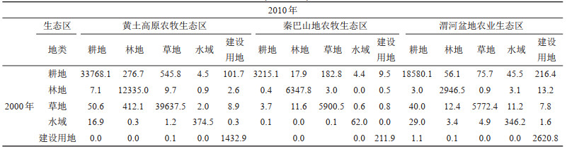
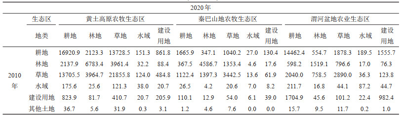
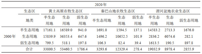
研究结果 结果表明:(1)2000—2010年流域耕地转换为草地、林地以及建设用地的面积分别为804.4 km2、350.3 km2、327.6 km2,而草地、林地以及建设用地转换为耕地的面积分别为94.3 km2、10.4 km2、1.2 km2;(2)2010—2020年流域耕地转换为草地、林地以及建设用地的面积分别为16646.8 km2、3024.5 km2、2547.9 km2,而草地、林地以及建设用地转换为耕地的面积分别为16867.7 km2、3103.6km2、2528.82 km2;(3)2000—2020年流域生态空间用地面积转换达48165 km2,其中生态用地→半生态用地面积为20172 km2,半生态用地→生态用地面积为20897 km2,弱生态用地→半生态用地面积为2519 km2,半生态用地→弱生态用地面积为2754 km2,反映流域生态空间用地转换趋于平衡和生态系统服务质量稳中趋增。
结论 以上成果对于促进渭河流域自然资源综合区划和国土空间“三区三线”优化具有重要意义。
Abstract:This paper is the result of monitoring and evaluating engineering of natural resources.
Objective As a new expansion business of China Geological Survey in 2021, the comprehensive survey of natural resources aims to serve land and space planning, use control and ecological protection and restoration.
Methods Based on the monitoring data of land use/cover change in the watershed in 2000, 2010, and 2020, ArcGIS software was used to analyze the spatiotemporal changes in land use types and ecological space of Weihe River Basin.
Results The results show that: 1) during 2000-2010, 804.4 km2, 350.3 km2 and 327.6 km2 of cropland converted into grassland, forest and constructive land respectively, while only 94.3 km2 grassland, 10.4 km2 forest and 1.2 km2 constructive land converted into cropland; 2) during 2010-2020, 16646.8 km2, 3024.5 km2 and 2547.9 km2 of cropland converted into grassland, forest and constructive land respectively, while 16867.7 km2 grassland, 3103.6 km2 forest and 2528.82 km2 constructive land converted into cropland; 3) during 2000-2020, the conversion of ecological space land in this region reaches 48,165 km2, of which the ecological→semi-ecological land was 20172 km2, the semi-ecological→ecological land was 20,897 km2, the weak ecological→semi-ecological land was 2,519 km2, and the semi-ecological→weak ecological land was 2754 km2. It reflects that the conversion of ecological space land in the region tends to balance and the quality of the ecosystem is slowly increasing.
Conclusions The results is of great significance for accelerating comprehensive regionalization of natural resources and optimizes "three-zone and the-lines" of the Territorial Spatial Plan in the Weihe River Basin.
-

-
表 1 渭河流域各生态区2000—2010年自然资源动态变化转移矩阵(面积/km2)
Table 1. Land use change area in different ecological space and transfer matrix of Wei River Basin from 2000 to 2010 (area/km2)
 下载: 导出CSV
表 2 渭河流域各生态区2010—2020年自然资源动态变化转移矩阵(面积/km2)
Table 2. Land use change area in different ecological space and transfer matrix of Wei River Basin from 2010 to 2020 (area/km2)
 下载: 导出CSV
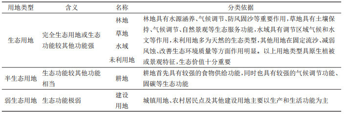
表 3 生态空间分类及与土地利用类型的对应关系(据刘小燕等,2021修改)
Table 3. Corresponding relation between the classification of ecological space and land use(modified from Liu Xiaoyan et al., 2021)
 下载: 导出CSV
表 4 渭河流域各生态区2000-2020年生态用地转移矩阵(面积/km2)
Table 4. Ecological land use change area in different ecological space and transfer matrix of Wei River Basin from 2000 to 2020 (area/km2)
 下载: 导出CSV
-
Cheng Lei, Xu Zongxue, Luo Rui, Mi Yanjiao. 2009. Spatial-temporal characteristics of LUCC and driving factor analysis for the Wei River Basin from 1980 to 2000[J]. Research of Soil and Water Conservation, 16(5): 1-6, 30 (in Chinese with English abstract).
Cheng Sanyou, Wang Hongmei, Li Yingjie. 2011. Geomorphology characteristics of the Wei River Basin and its formation reasons[J]. Geography and Geo- Information Science, 27(3): 45-49 (in Chinese with English abstract).
Cheng Weiming, Zhou Chenghu, Li Bingyuan, Shen Yuancun. 2019. Geomorphological regionalization theory system and division methodology of China[J]. Acta Geographica Sinica, 74(5): 839-856 (in Chinese with English abstract).
Fu Bojie, Liu Guohua, Chen Liding, Ma Keming, Lijunran. 2001. Scheme of ecological regionalization in China[J]. Acta Ecologica Sinica, 21(1): 1-6 (in Chinese with English abstract).
Guo Jinjing, Han Wenfeng, Liang Shouyun. 2006. Tectonomorphological evolution of the Minxian-Wudu area on the northeastern margin of the Qinghai-Xizang Plateau and plateau uplift[J]. Geology in China, 33(2): 383-392(in Chinese with English abstract).
Han Yanfei, Ke Changqing, Li Jing. 2014. Response of vegetation net primary productivity to LUCC in Guanzhong-Tianshui Economic Zone in recent 30 years[J]. Journal of Arid Land Resources and Environment, (6): 68-74(in Chinese with English abstract).
Li Yangchun, Zhang Kexin, He Weihong, Xu Yadong, Song Bowen, Yu Yang, Ke Xue, Kou Xiaohu, Luo Mansheng, Xin Houtian, Fu Junyu, Yang Zhuliang, Zhao Xiaoming, Yin Fuguang, Li Zhipei. 2018. Division of tectonic-strata superregions in China[J]. China Geology, 1(2): 236-256. doi: 10.31035/cg2018028
Li Guangdong, Fang Chuanglin. 2016. Quantitative function identification and analysis of urban ecological-production-living spaces[J]. Acta Geographica Sinica, 71(1): 49-65(in Chinese with English abstract).
Li Hongyan, Li Jing. 2014. Study on the transfer of ecological service value in Guanzhong-Tianshui economic zone[J]. Journal of Shaanxi Normal University (Natural Science Edition), 42(1): 86-91(in Chinese with English abstract).
Li Libo, Xu Gang, Hu Jianmin, Yu Xinbin. 2012. An analysis of relative active tectonics based on DEM[J]. Geology in China, 39(3): 595-604 (in Chinese with English abstract)
Li Nanqian, Chen Jianwei. 2011. New approach of forest zoning in China[J]. Forestry Resources Management, (4): 1-5 (in Chinese with English abstract).
Li Shuoyang, Liu Xiaoyan, Yang Guiyu, Liu Qizhen. 2021. Analysis of the impact of land use change on runoff in the Weihe River Basin from the perspective of hydrologic factor variation[J]. Research of Soil and Water Conservation, 28(3): 133-140 (in Chinese with English abstract).
Li Zi, Zhang Yanfang. 2021. Spatiotemporal evolution of ecosystem services in the main and tributaries of Weihe River Basin based on InVEST model[J]. Acta of Soil and Water Conservation, 35(4): 178-185 (in Chinese with English abstract).
Liu Xiaoyan, CuiYaoping, Dong Jinwei, Shi Zhifang, Run Yadi. 2021. Assessment of ecological space and ecological index changes in the affected area of the middle and lower reaches of the Yellow River[J]. Acta Ecologica Sinica, 41(20): 8030-8039 (in Chinese with English abstract).
Ministry of Natural Resources of People's Republic of China. 2018. Implementation Plan of the Third National Land Survey[S]. 1-58(in Chinese).
Ning Yazhou, Zhang Fuping, Feng Qi, Wei Yongfen, Ding Jiabao, Zhang Yuan. 2020. Temporal and spatial variation of water conservation function in Qinling Mountain and its influencing factors[J]. Chinese Journal of Ecology, 39(9): 3080-3091(in Chinese with English abstract).
Pang Jiatai, Duan Jinliang, Li Zhi, Lü Jichao. 2021. Characteristics of spatiotemporal evolution and climate response of vegetation cover in the Wei River Basin from 2000 to 2019[J]. Research of Soil and Water Conservation, 28(5): 230-237(in Chinese with English abstract).
Song Weinian, Zhan Chensheng, Li Jingyu, Xu Zongxue, Wang Huixiao. 2012. Remote sensing analysis on the spatial-temporal characteristics of LUCC in the Guanzhong Plain Region of the Wei River Basin in the past 30 years[J]. China Land Science, 26(2): 56-61(in Chinese with English abstract).
Wang Fei. 2013. Study of Runoff and Value of Ecosystem Services Based on Land Use Change in Weihe River Basin[D]. Xianyang: Northwest A&F University, 1-60.
Wang Lixia, Zhang Mingshuang, Sui Lichun, Zhang Shuangcheng, Yang Yun. 2020. Ecological function regionalization in the Weihe River Basin[J]. Arid Zone Research, 37(1): 236-243(in Chinese with English abstract).
Wang Peng, Zhao Jun, Yan Xiaojuan, Yang Tao, Zhang Jing, Ma Shangwei, Zhang Daojun. 2023. Agglomeration and evolution characteristics of urban land- use efficiency under a dynamic spatio-temporal perspective in the Yellow River Basin[J]. Geology in China, 50(2): 506-520(in Chinese with English abstract)
Wang Yingguo, Chang Hong, Zhou Weijian. 2021. Fluvial terrace evolution and its tectonic- climatic significance in the Weihe Basin[J]. Geological Review, 67(4): 1033-1049 (in Chinese with English abstract).
Wu Bo, Guo Shuhai, Li Baolin, Zhang Lingyan. 2018. Draft of soil environmental function regionalization of China[J]. Chinese Journal of Applied Ecology, 29(3): 961-968(in Chinese with English abstract).
Xie Gaodi, Zhen Lin, Lu Chunxia, Xiao Yu, Chen Cao. 2008. Expert knowledge based valuation method of ecosystem services in China[J]. Journal of Resources and Ecology, 23(5): 911-919(in Chinese with English abstract).
Xu Shengchao, Zhao Xueyan, Song Xiaoyu. 2021. Impacts of the returning farmland to forest (grassland) project on ecosystem services in the Weihe River Basin, China[J]. Chinese Journal of Applied Ecology, 32(11): 3893-3904(in Chinese with English abstract).
Yang Shengtian, Liu Changming, Sun Rui. 2004. The vegetation cover last 20 years in Yellow River Basin[J]. Acta Geographica Sinica, 57(6): 679-684(in Chinese with English abstract).
Yang Yong, Ren Zhiyuan. 2013. A comparative study on LUCC of Guanzhong area based on GIS[J]. Journal of Arid Land Resources and Environment, 27(5): 40-45(in Chinese with English abstract).
Yue Siyu, Li Huaien, Zhao Li. 2021. Impact of climate and land use changes on water scarcity in the Wei River Basin[J]. Research of Soil and Water Conservation, 28(5): 95-101(in Chinese with English abstract).
Zhang Dong, Song Xianfang, Zhang Yinghua, Yang Lihu, Yang Shengtian. 2018. Variation characteristics of precipitation over Weihe river basin based on CRU Grid Dataset during last 100 years[J]. Journal of Arid Land Resources and Environment, 32(2): 142-148 (in Chinese with English abstract).
Zhang Haiyan, Fan Jiangwen, Huang Lin, Tang Yulei, Yue Ying, Yang Yu, Liu Xiaohuang. 2020. Theories and technical methods for the comprehensive regionalization of natural resources in China[J]. Resources Science, 42(10): 1870-1882 (in Chinese with English abstract).
Zhang Yan, Bi Zhilei, Song Jinxi, Li Nan. 2019. Effects of land-use types on nitrate pollution of surface water in Guanzhong area in the Weihe River basin[J]. Acta Ecologica Sinica, 39(12): 4319-4327(in Chinese with English abstract).
Zhang Qionghua, Zhao Jingbo. 2005. Analysis on the main factors resulting in flood disasters in the Weihe River watershed and the control measures[J]. Arid Zone Research, 22(4): 485-490 (in Chinese with English abstract).
Zheng Jingyun, Yin Yunhe, Li Bingyuan. 2010. A new scheme for climate regionalization in China[J]. Acta Geographica Sinica, 65(1): 3-12 (in Chinese with English abstract).
程磊, 徐宗学, 罗睿, 米艳娇. 2009. 渭河流域1980-2000年LUCC时空变化特征及其驱动力分析[J]. 水土保持研究, 16(5): 1-6, 30. https://www.cnki.com.cn/Article/CJFDTOTAL-STBY200905002.htm
程三友, 王红梅, 李英杰. 2011. 渭河水系流域地貌特征及其成因分析[J]. 地理与地理信息科学, 27(3): 45-49. https://www.cnki.com.cn/Article/CJFDTOTAL-DLGT201103012.htm
程维明, 周成虎, 李炳元, 申元村. 2019. 中国地貌区划理论与分区体系研究[J]. 地理学报, 74(5): 839-856. https://www.cnki.com.cn/Article/CJFDTOTAL-DLXB201905002.htm
傅伯杰, 刘国华, 陈利顶, 马克明, 李俊然. 2001. 中国生态区划方案[J]. 生态学报, 21 (1): 1-6. https://www.cnki.com.cn/Article/CJFDTOTAL-STXB200101000.htm
郭进京, 韩文峰, 梁收运. 2006. 青藏高原东北缘岷县-武都地区构造地貌演化与高原隆升[J]. 中国地质, 33(2): 383-392. http://geochina.cgs.gov.cn/geochina/article/abstract/20060217?st=search
韩艳飞, 柯长青, 李晶. 2014. 近30年关天经济区植被净初级生产力对土地利用变化的动态响应[J]. 干旱区资源与环境, (6): 68-74. https://www.cnki.com.cn/Article/CJFDTOTAL-GHZH201406012.htm
李广东, 方创琳. 2016. 城市生态-生产-生活空间功能定量识别与分析[J]. 地理学报, 71(1): 49-65. https://www.cnki.com.cn/Article/CJFDTOTAL-DLXB201601004.htm
李红艳, 李晶. 2014. 关中-天水经济区生态系统服务价值转移研究[J]. 陕西师范大学学报, 42(1): 86-91. https://www.cnki.com.cn/Article/CJFDTOTAL-SXSZ201401019.htm
李烁阳, 刘小燕, 杨贵羽, 刘奇真. 2021. 土地利用变化对渭河流域水文过程的影响[J]. 水土保持研究, 28(3): 133-140. https://www.cnki.com.cn/Article/CJFDTOTAL-STBY202103020.htm
李利波, 徐刚, 胡健民, 于新兵. 2012. 基于DEM的活动构造研究[J]. 中国地质, 39(3): 595-604. http://geochina.cgs.gov.cn/geochina/article/abstract/20120303?st=search
李南岍, 陈建伟. 2011. 对中国森林区划的新探讨[J]. 林业资源管理, (4): 1-5. https://www.cnki.com.cn/Article/CJFDTOTAL-LYZY201104002.htm
李子, 张艳芳. 2021. 基于InVEST模型的渭河流域干支流生态系统服务时空演变特征分析[J]. 水土保持学报, 35(4): 178-185. https://www.cnki.com.cn/Article/CJFDTOTAL-TRQS202104025.htm
刘小燕, 崔耀平, 董金玮, 史志方, 闰亚迪. 2021. 黄河中下游影响区生态空间和生态指数变化评估[J]. 生态学报, 41(20): 8030-8039. https://www.cnki.com.cn/Article/CJFDTOTAL-STXB202120012.htm
宁亚洲, 张福平, 冯起, 魏永芬, 丁家宝, 张元. 2020. 秦岭水源涵养功能时空变化及其影响因素[J]. 生态学杂志, 39(9): 3080-3091. https://www.cnki.com.cn/Article/CJFDTOTAL-STXZ202009028.htm
庞家泰, 段金亮, 李智, 吕继超. 2021. 2000-2019年渭河流域植被覆盖度时空演变特征及气候响应[J]. 水土保持研究. 28(5): 230-237. https://www.cnki.com.cn/Article/CJFDTOTAL-STBY202105033.htm
宋维念, 占车生, 李景玉, 徐宗学, 王会肖. 2012. 近30年来渭河关中地区土地利用时空格局的遥感分析[J]. 中国土地科学, 26(2): 56-61. https://www.cnki.com.cn/Article/CJFDTOTAL-ZTKX201202011.htm
王飞. 2013. 基于土地利用变化的渭河流域产流及生态系统服务价值研究[D]. 咸阳: 西北农林科技大学, 1-60.
王丽霞, 张茗爽, 隋立春, 张双成, 杨耘. 2020. 渭河流域生态功能区划[J]. 干旱区研究, 37(1): 236-243. https://www.cnki.com.cn/Article/CJFDTOTAL-GHQJ202001028.htm
王鹏, 赵君, 阎晓娟, 杨涛, 张晶, 马尚伟, 张道军. 2023. 动态时空视角下黄河流域城市土地利用效率的集聚演化特征[J]. 中国地质, 50(2): 506-520. http://geochina.cgs.gov.cn/geochina/article/abstract/20230213?st=search
王迎国, 常宏, 周卫健. 2021. 渭河盆地河流阶地演化及其构造-气候意义[J]. 地质论评, 67(4): 1033-1049. https://www.cnki.com.cn/Article/CJFDTOTAL-DZLP202104014.htm
吴波, 郭书海, 李宝林, 张玲姸. 2018. 中国土壤环境功能区划方案[J]. 应用生态学报, 29(3): 961-968. https://www.cnki.com.cn/Article/CJFDTOTAL-YYSB201803035.htm
谢高地, 甄霖, 鲁春霞, 肖玉, 陈操. 2008. 一个基于专家知识的生态系统服务价值化方法[J]. 自然资源学报, 23(5): 911-919. https://www.cnki.com.cn/Article/CJFDTOTAL-ZRZX200805019.htm
徐省超, 赵雪雁, 宋晓谕. 2021. 退耕还林(草)工程对渭河流域生态系统服务的影响[J]. 应用生态学报, 32(11): 3893-3904. https://www.cnki.com.cn/Article/CJFDTOTAL-YYSB202111013.htm
杨胜天, 刘昌明, 孙睿. 2004. 近20年来黄河流域植被覆盖变化分析[J]. 地理学报, 57(6): 679-684. https://www.cnki.com.cn/Article/CJFDTOTAL-DLXB200206006.htm
杨勇, 任志远. 2013. 基于GIS的关中地区土地利用/覆盖变化对比研究[J]. 干旱区资源与环境, 27(5): 40-45. https://www.cnki.com.cn/Article/CJFDTOTAL-GHZH201305007.htm
岳思羽, 李怀恩, 赵丽. 2021. 气候和土地利用变化对渭河流域水资源短缺的影响[J]. 水土保持研究, 28(5): 95-101. https://www.cnki.com.cn/Article/CJFDTOTAL-STBY202105016.htm
张东, 宋献方, 张应华, 杨丽虎, 杨胜天. 2018. 基于CRU格点数据集的近百年渭河流域降水变化[J]. 干旱区资源与环境, 32(2): 142-148. https://www.cnki.com.cn/Article/CJFDTOTAL-GHZH201802022.htm
张海燕, 樊江文, 黄麟, 汤宇磊, 岳颖, 杨玉, 刘晓煌. 2020. 中国自然资源综合区划理论研究与技术方案[J]. 资源科学, 42(10): 1870-1882. https://www.cnki.com.cn/Article/CJFDTOTAL-ZRZY202010005.htm
张琼华, 赵景波. 2005. 渭河流域洪水灾害关键因素分析及防治对策[J]. 干旱区研究, 22(4): 485-490. https://www.cnki.com.cn/Article/CJFDTOTAL-GHQJ200504012.htm
张妍, 毕直磊, 张鑫, 宋进喜, 李楠. 2019. 土地利用类型对渭河流域关中段地表水硝酸盐污染的影响[J]. 生态学报, 39(12): 4319-4327. https://www.cnki.com.cn/Article/CJFDTOTAL-STXB201912011.htm
郑景云, 尹云鹤, 李炳元. 2010. 中国气候区划新方案[J]. 地理学报, 65(1): 3-12. https://www.cnki.com.cn/Article/CJFDTOTAL-DLXB201001003.htm
中华人民共和国自然资源部. 2018. 第三次全国国土调查实施方案[S]. 1-58.
-

图(4)
表(4)
计量
- 文章访问数: 1878
- PDF下载数: 151
- 施引文献: 0