

Identification and feature analysis of regional loess landslides based on UAV tilt photogrammetry 3D modeling
-
摘要:
研究目的 黄土滑坡是黄土地区人居与城镇建设安全的重大隐患。滑坡识别是滑坡灾害及其他研究工作的基础,因此基于无人机倾斜摄影测量三维建模从不同维度、不同视角直观快速地识别黄土滑坡并进行特征参数提取,能够为黄土滑坡风险识别及风险管理精细化研究提供技术支撑。
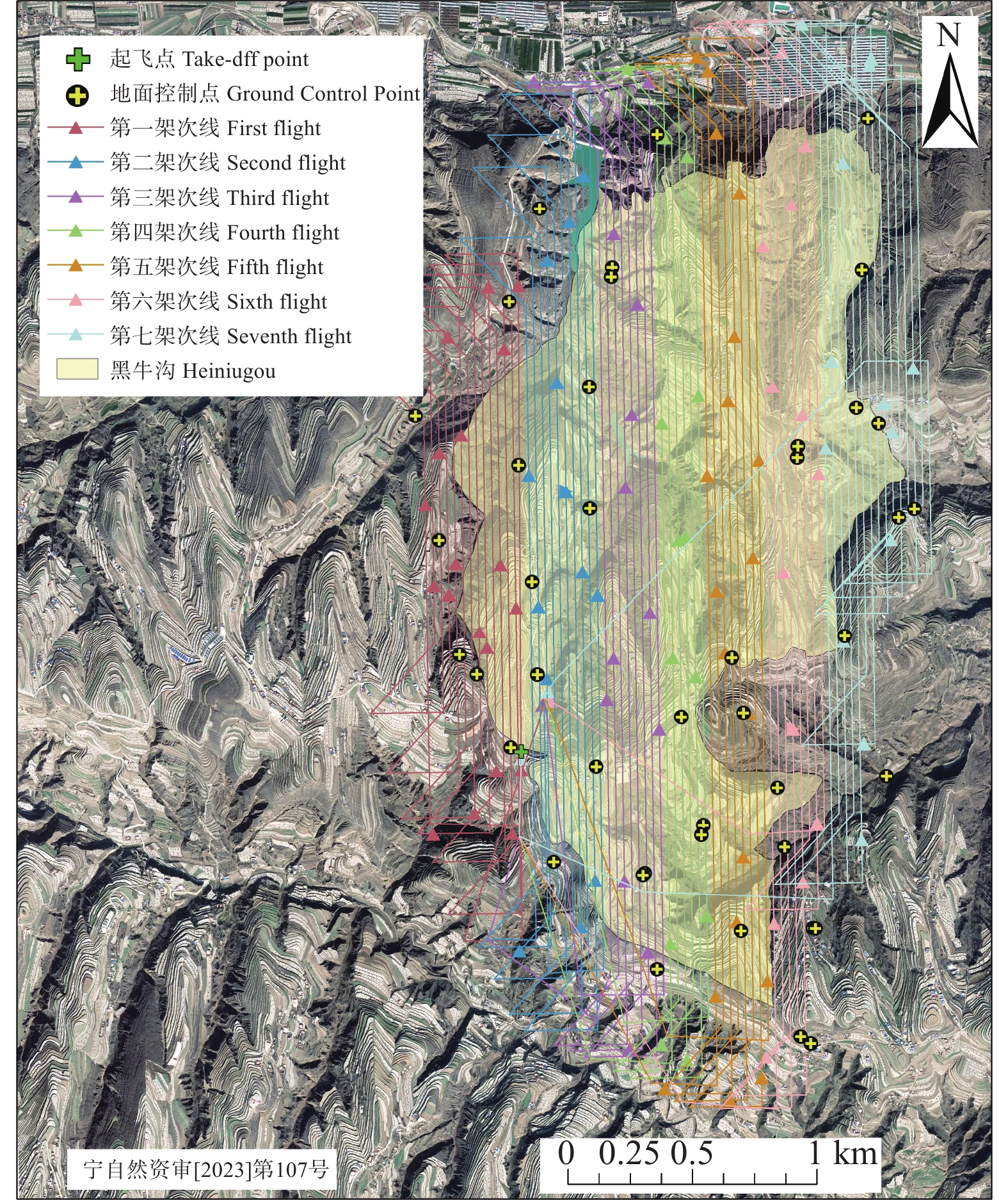
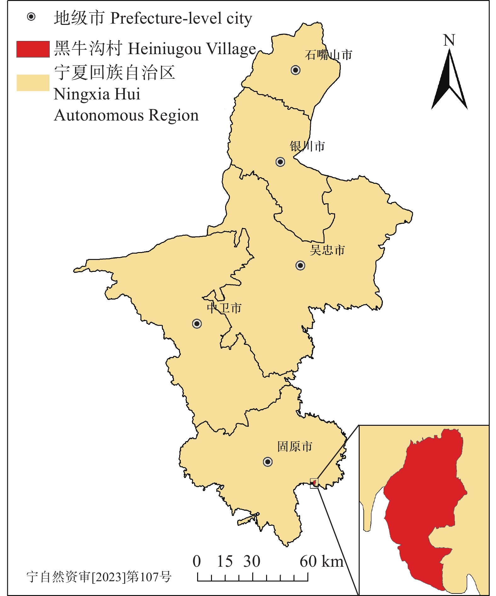
研究方法 以宁夏回族自治区固原市彭阳县红河镇西南部的黑牛沟村为研究区,采用无人机倾斜摄影测量数据获取、三维建模、现场验证结合地统计学分析,开展了区域黄土滑坡识别及其特征参数提取和分析。
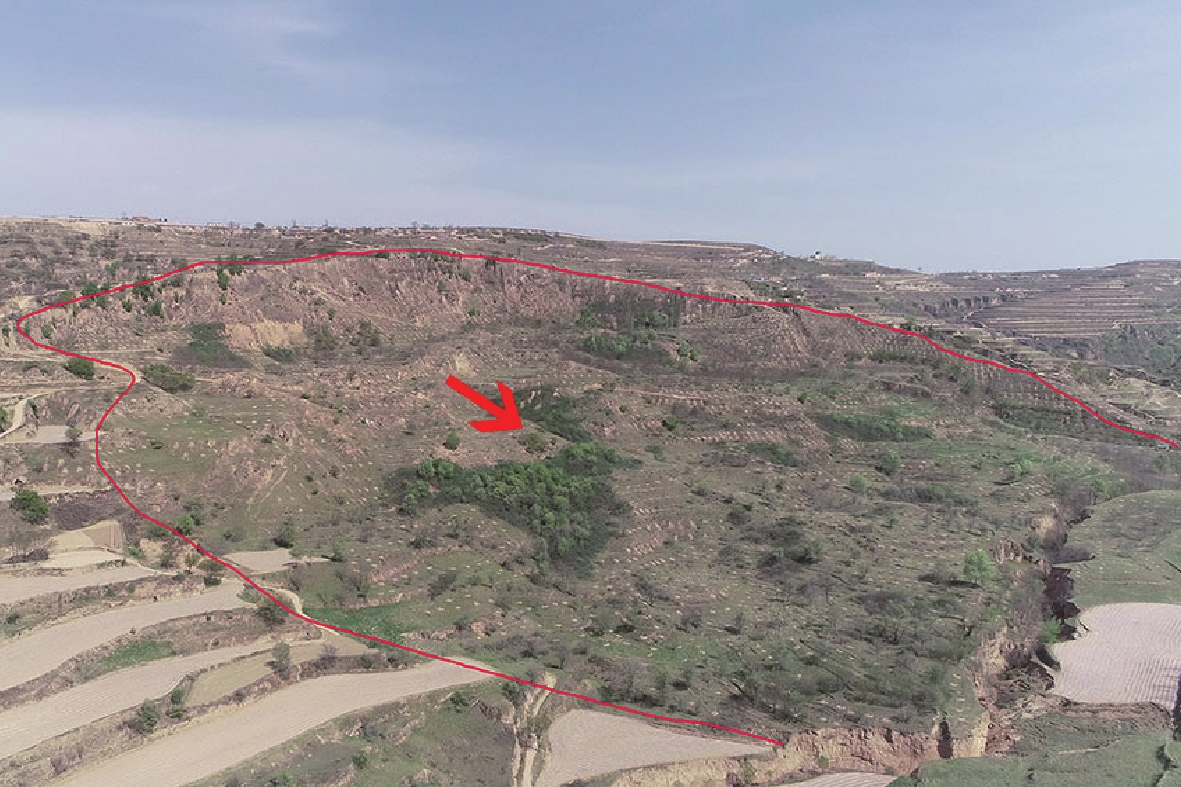
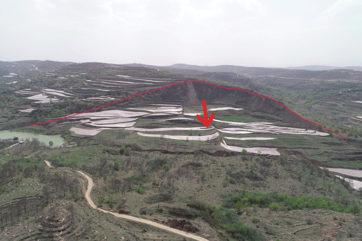
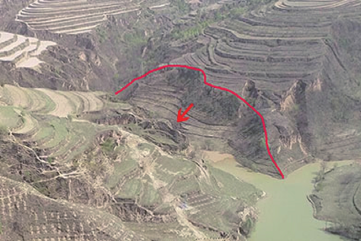
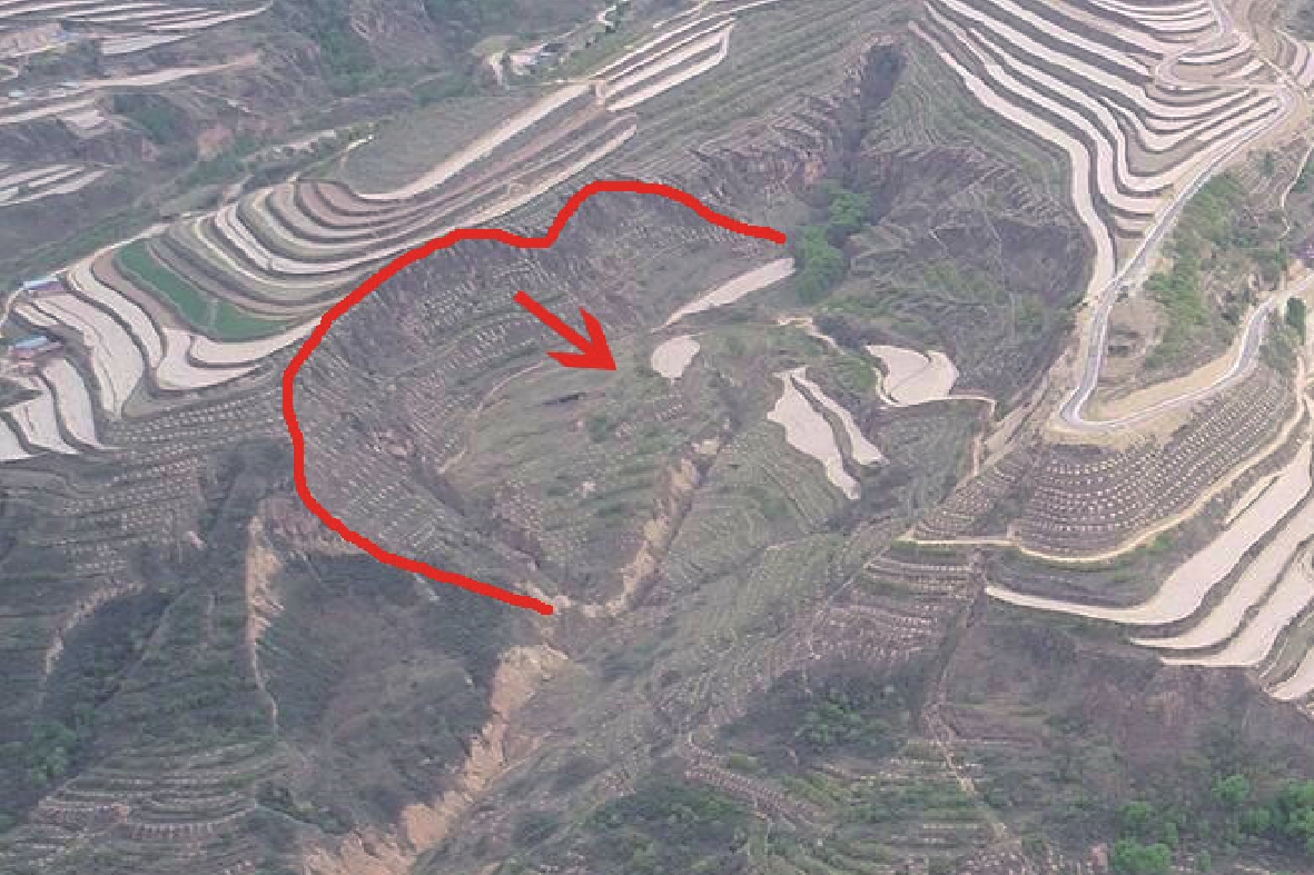
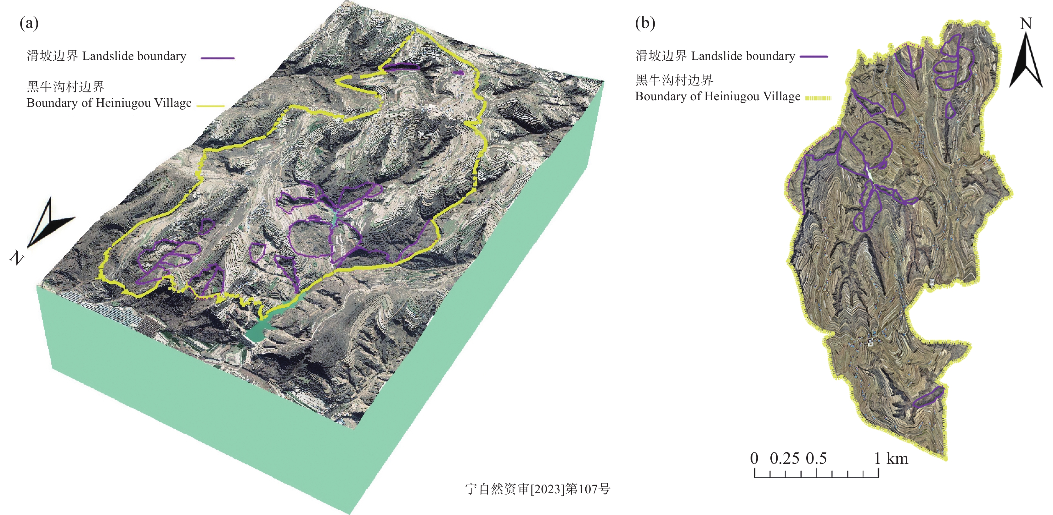
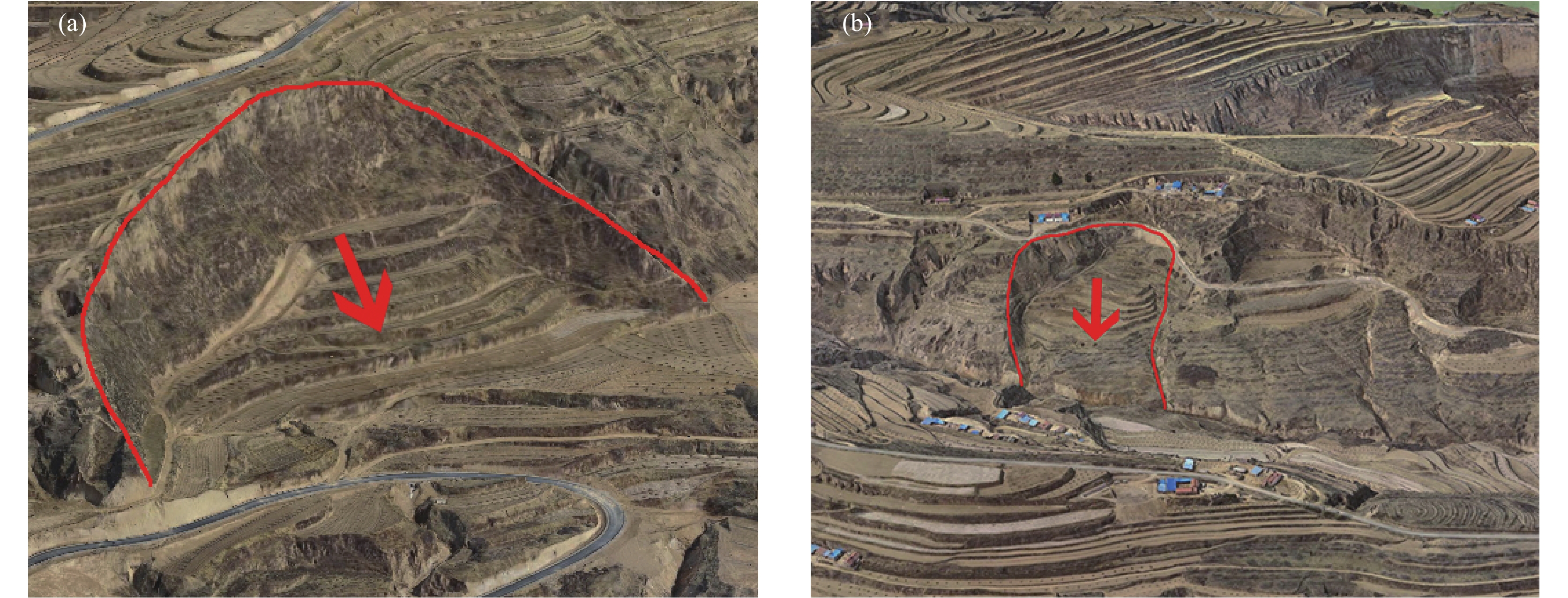
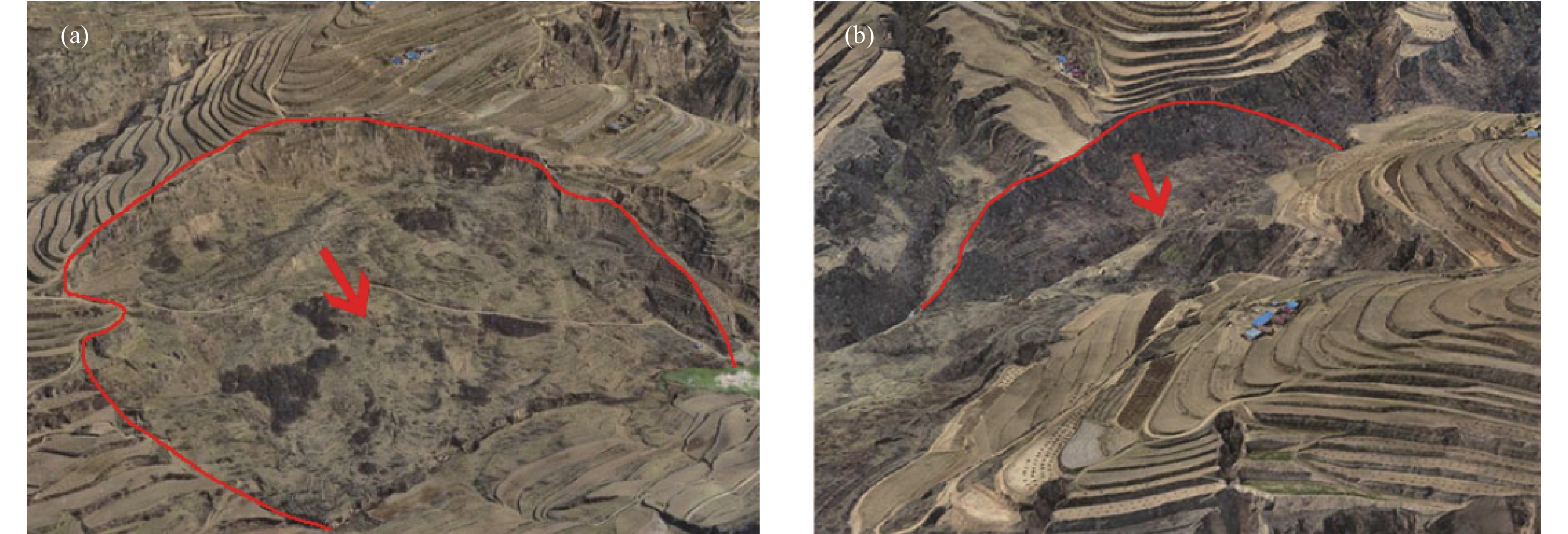
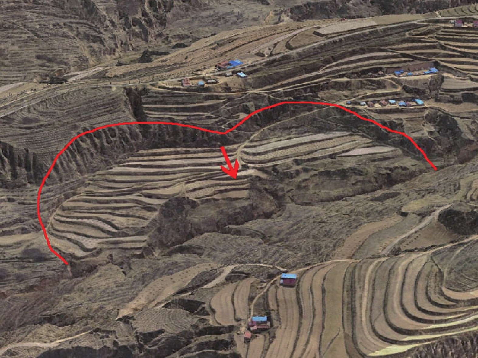
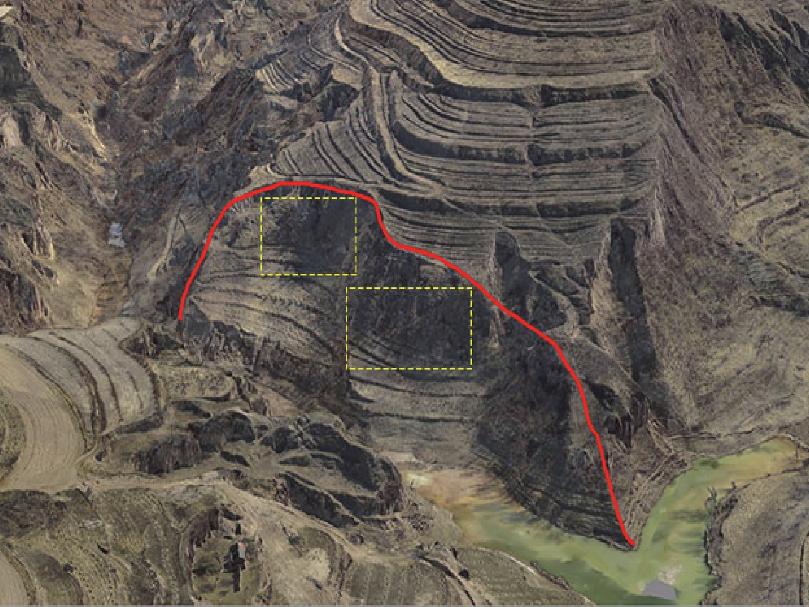
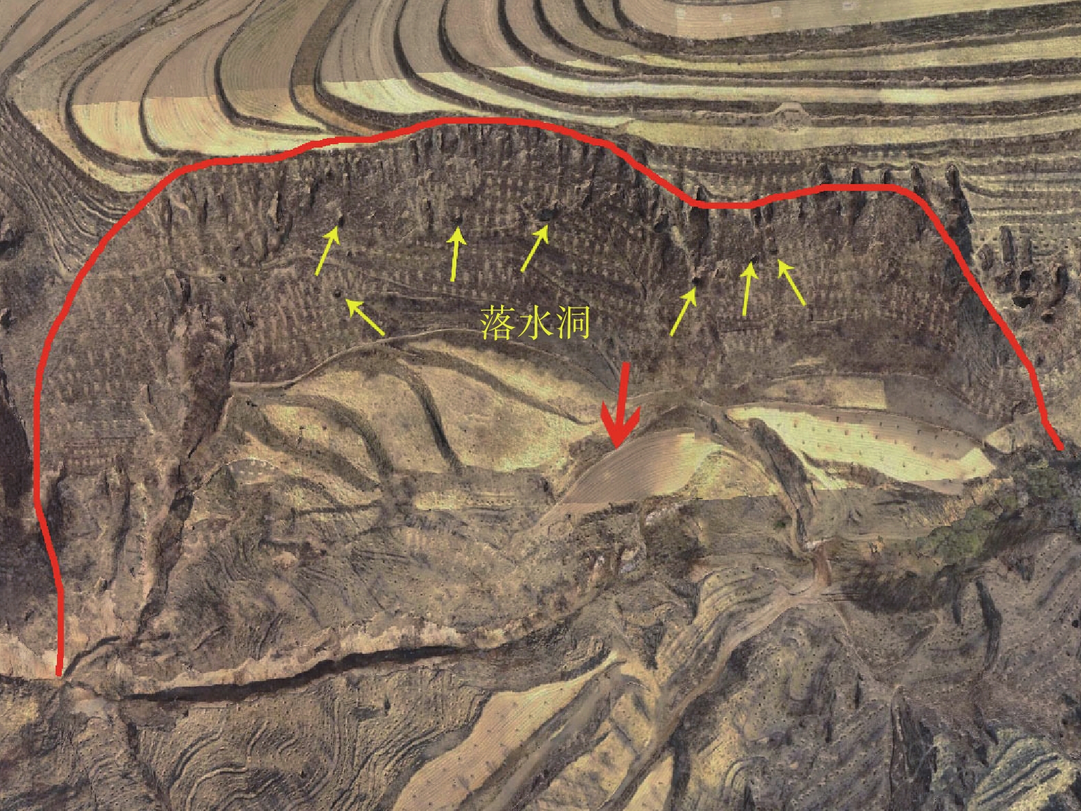
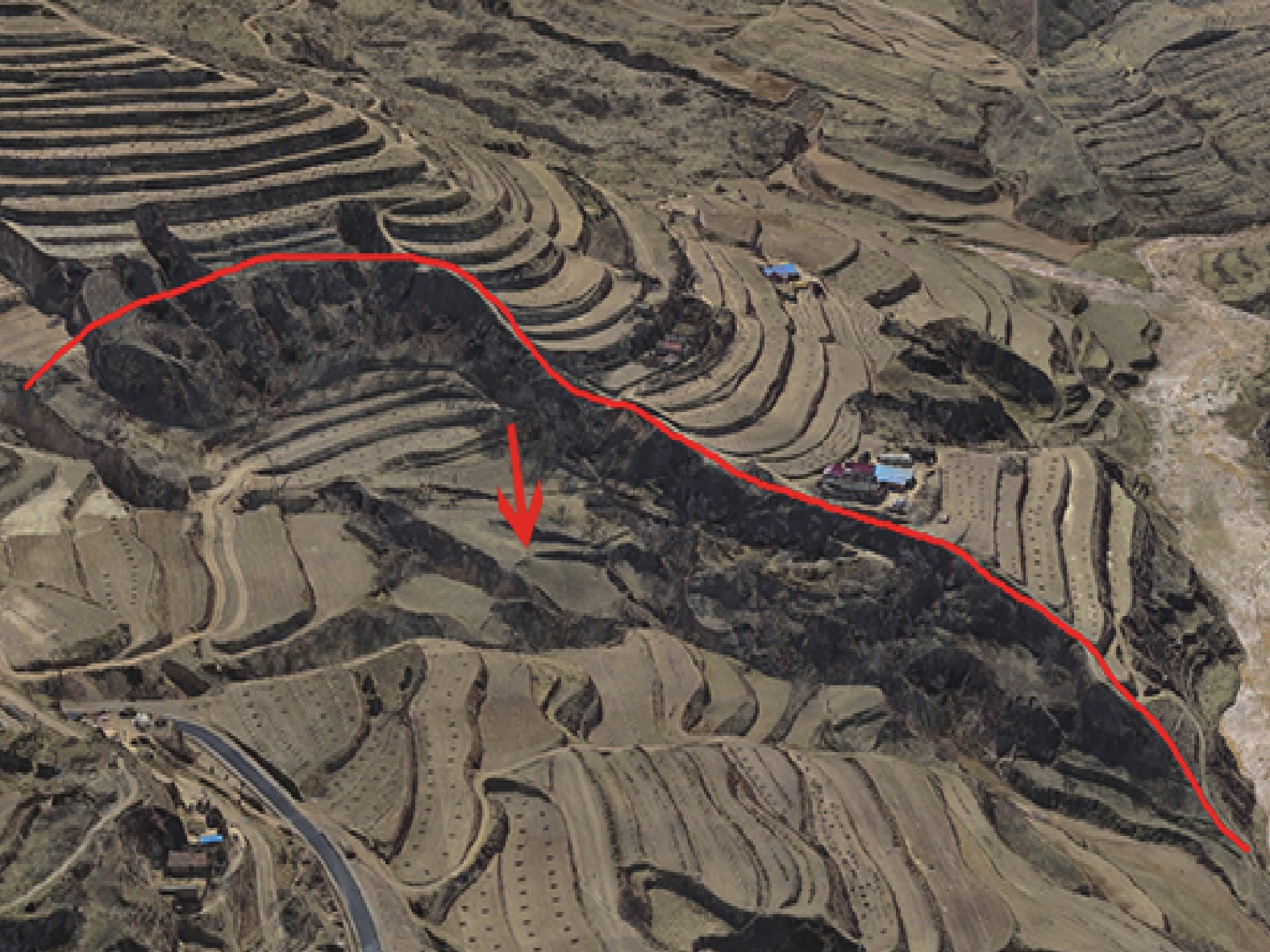
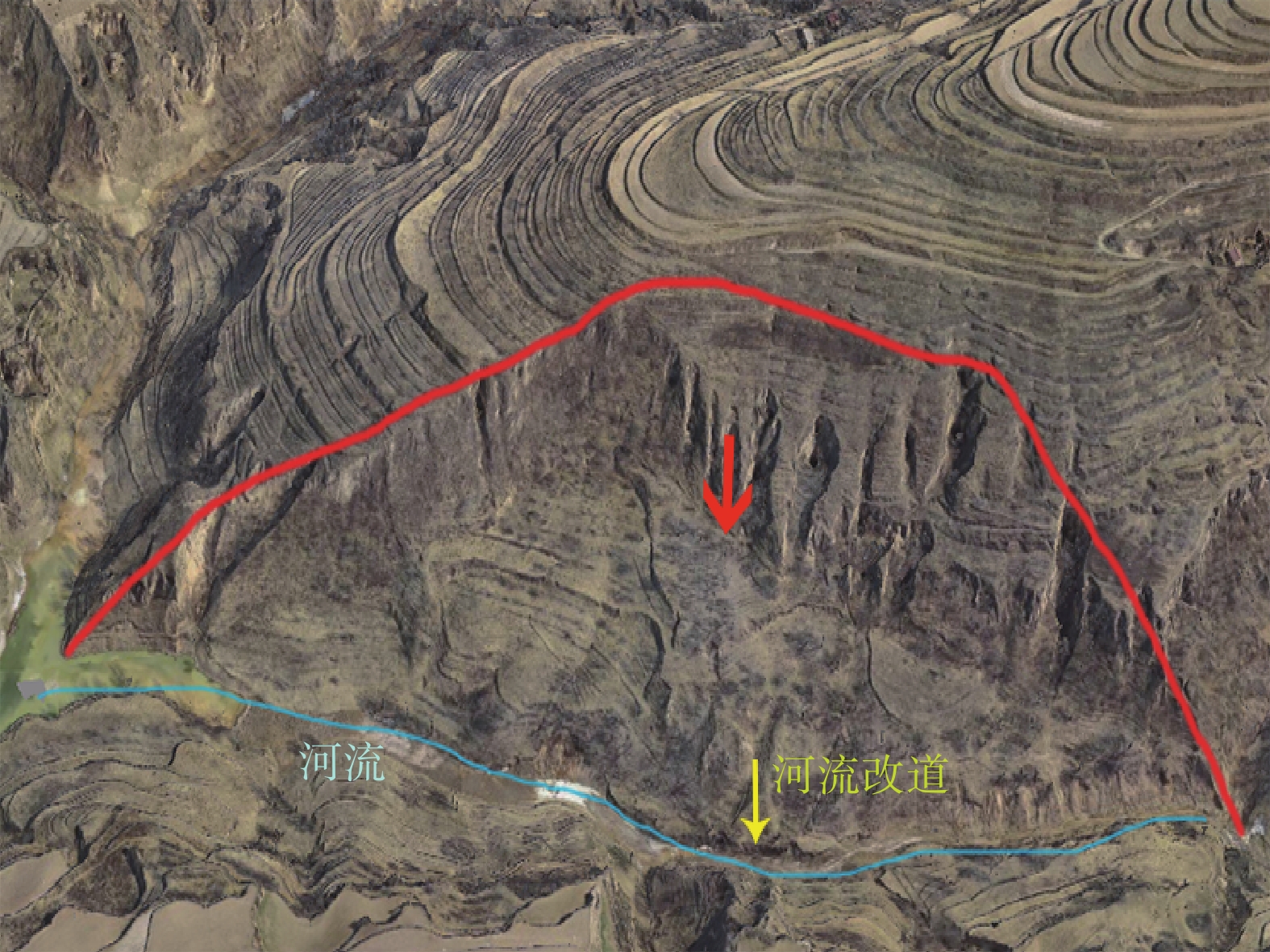
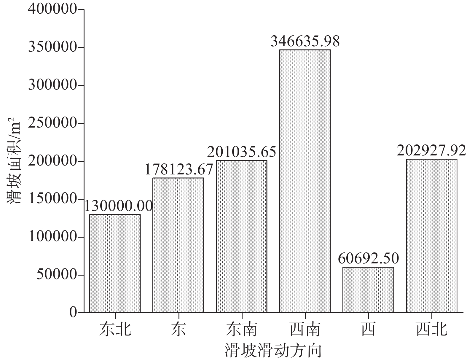
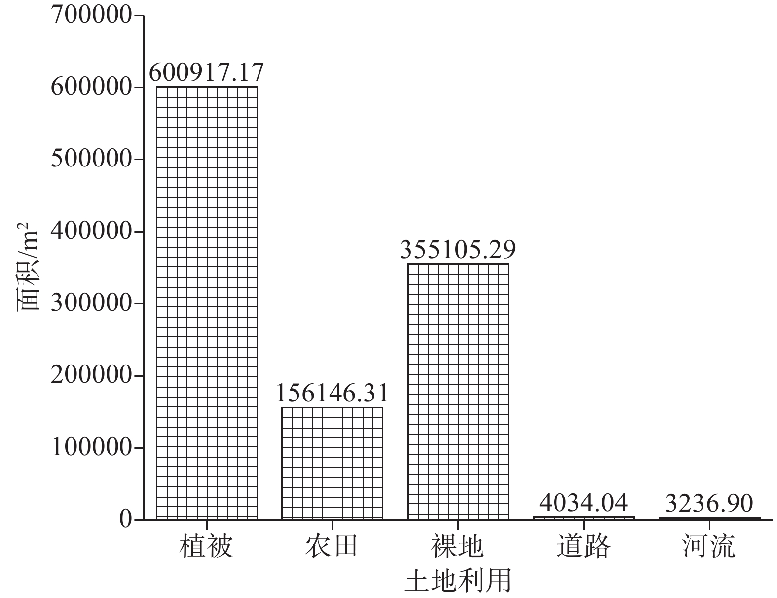
研究结果 基于三维实景模型确定并分析研究区沟谷沿线地貌凹陷区是否存在陡壁及其周界形态,结合色调、纹理和微地貌等标志实现了黄土滑坡识别,共圈定了23个滑坡,结合现场验证移除2个非滑坡点,最终确定了21个滑坡;滑坡密集分布在主沟和支沟沟口,多呈对滑的形式出现在沟谷两侧且具有群发性;大型及特大型滑坡占比达到57.14%,滑坡的滑动方向主要以西南(阳坡)、东南(半阳坡)为主,相对高差集中在80~120 m,滑坡体坡形多呈凹形坡,滑坡体坡度主要集中在20°~30°;滑坡体土地利用类型主要为植被,其次为裸地,也有一部分为农田,道路和河流占比极少。
结论 基于无人机倾斜摄影测量构建的三维实景模型可从多维度、多视角精确快速地识别区域黄土滑坡,并分析其相关特征参数,能够弥补当前二维平面遥感影像存在的不足;还能够为滑坡易发性、危险性、易损性及风险评估等相关研究提供数据支撑。
Abstract:This paper is the result of geological hazard survey engineering.
Objective The loess landslide is a major hidden danger to the safety of human settlements and urban construction in the loess region. Landslide identification is the foundation of other research work on landslide disasters. By utilizing unmanned aerial vehicle oblique photogrammetry three-dimensional (3D) modeling, loess landslides can be intuitively and quickly identified from different dimensions and perspectives, enabling the extraction of feature parameters. This can provide technical support for risk identification and refined risk management research of loess landslides.
Methods While researching Heiniugou Village in the southwest of Honghe Town, Pengyang County, Guyuan City, and the Ningxia Hui Autonomous Region, regional loess landslide identification and feature parameter extraction and analysis were carried out using unmanned aerial vehicle oblique photogrammetry data acquisition, 3D modeling, on-site verification, and geostatistical analysis.
Results Based on a 3D−real−life model, we located steep walls and their surrounding shapes in the geomorphic depression areas along the valley in the study area. By combining color tone, texture, and micro-geomorphology indicators, we were able to identify all of the loess landslides in the specified region. A total of 23 landslides were delineated, and two non-landslide points were removed through on-site verification. The remaining 21 landslides were densely distributed at the mouth of the main and branch gullies, appearing to slide towards each other from opposite sides of the gullies and exhibiting a mass occurrence. The proportion of large and super−large landslides reached 57.14%. The landslides primarily slid to the southwest (sunny slope) and to the southeast (semi-sunny slope), with relative height differences between 80–120 m. The slopes of these landslides were mostly concave and measured between 20°–30°. The sites of these landslides were mainly sources of vegetation, bare land, or farmland, with a small percentage of the land made up of roads and rivers.
Conclusions A 3D-realistic model based on unmanned aerial vehicle oblique photogrammetry can accurately and quickly identify regional loess landslides from multiple dimensions and perspectives and analyze their related feature parameters, which can make up for the shortcomings of current two-dimensional planar remote sensing images. Moreover, this process can also provide data support for research on landslide susceptibility, danger, vulnerability, and risk assessment.
-

-
表 1 研究区典型黄土滑坡三维模型实景图及现场验证
Table 1. Realistic map and field verification of a typical loess landslide 3D model in the study area
滑坡编号 三维模型实景图 现场验证 HN10 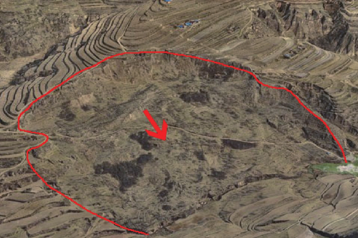
HN12 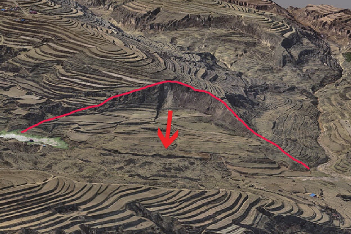
HN17 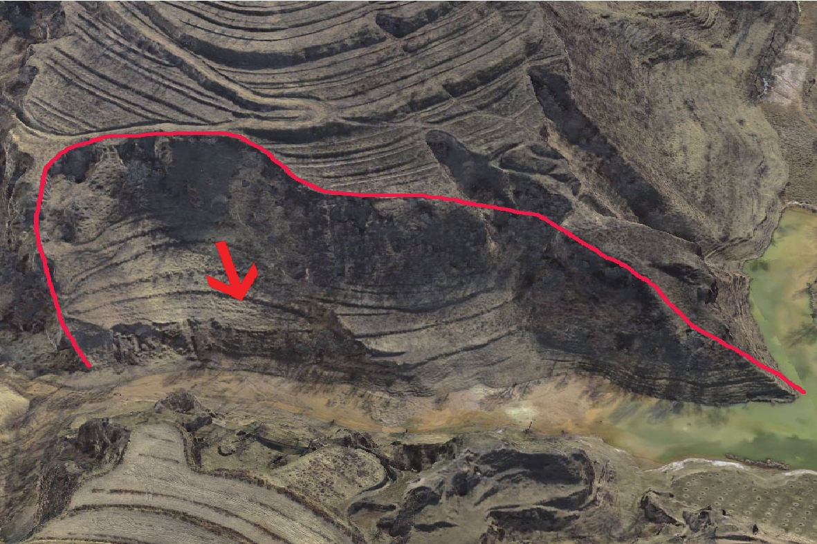
HN04 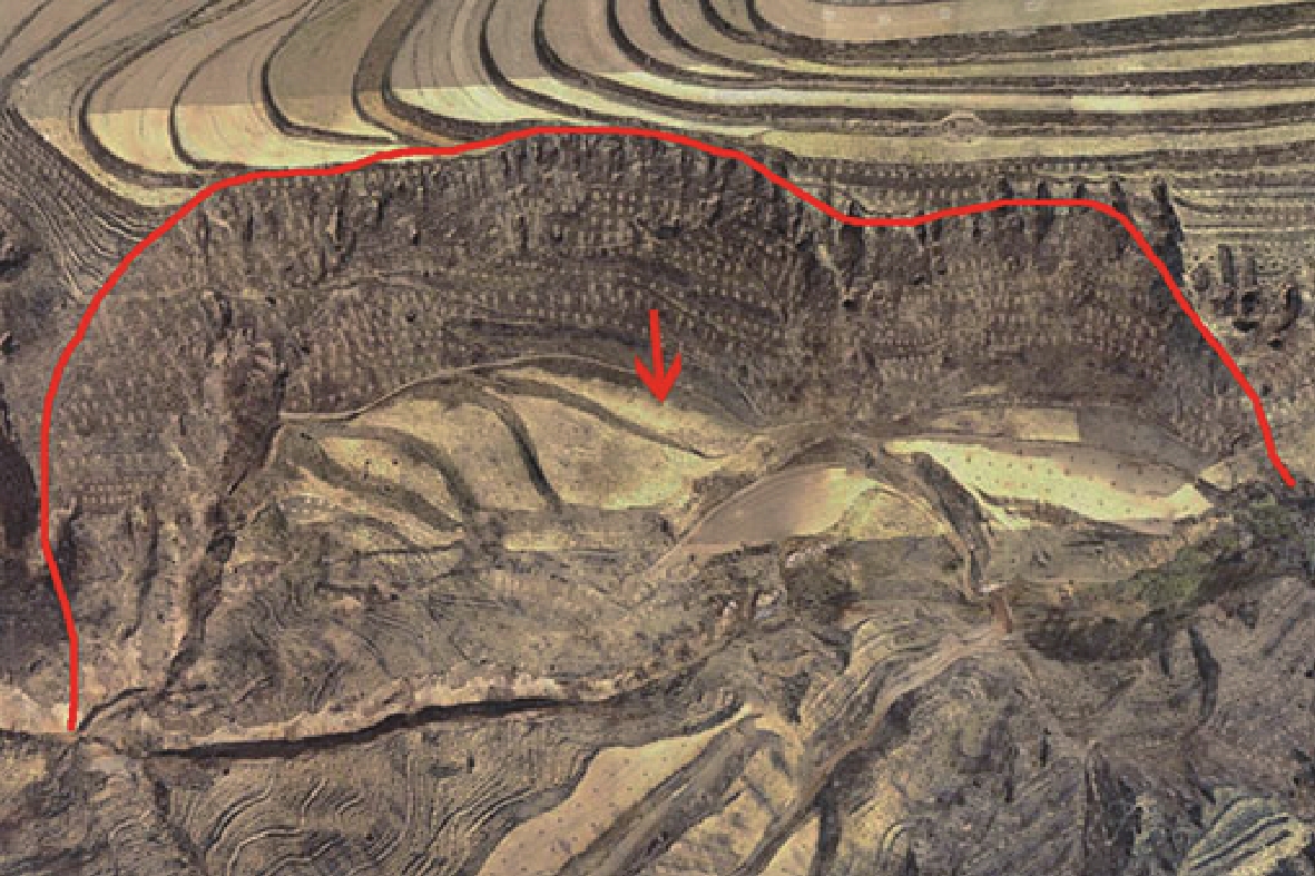
 下载: 导出CSV
表 2 研究区滑坡规模参数及分类统计
Table 2. Statistics of landslide scale parameters and classification in the study area
序号 面积/m2 体积/m3 规模分类 不同滑坡规模
数量占比/%HN10 200000.00 12874504.46 特大型滑坡 4.76 HN11 93109.29 3198563.09 大型滑坡 52.38 HN13 60692.50 2132063.60 大型滑坡 HN08 27962.60 1289852.99 大型滑坡 HN12 130000.00 4891470.36 大型滑坡 HN05 43478.31 3044124.96 大型滑坡 HN06 65486.60 9025757.73 大型滑坡 HN01 47871.17 2445661.20 大型滑坡 HN02 37306.10 2073038.93 大型滑坡 HN03 36606.17 1570681.05 大型滑坡 HN04 74556.36 3771416.47 大型滑坡 HN15 120000.00 8107899.04 大型滑坡 HN09 28601.31 874344.68 中型滑坡 38.10 HN19 6479.32 198073.47 中型滑坡 HN14 4091.98 116540.35 中型滑坡 HN20 25444.19 654278.30 中型滑坡 HN16 33164.47 699444.33 中型滑坡 HN17 13306.68 337214.37 中型滑坡 HN07 16863.67 653954.94 中型滑坡 HN18 13280.62 336740.34 中型滑坡 HN21 41114.39 1712871.97 小型滑坡 4.76 注:按照地质灾害风险调查评价规范(1:50000)(DZ/T 0439−2023)中滑坡体积进行滑坡规模分类。
下载: 导出CSV
表 3 研究区黄土滑坡滑动方向统计
Table 3. Statistics of landslide aspect in the study area
滑动方向 滑坡面积
/m2滑坡面积
占比/%滑坡
数量/个滑坡数量
占比/%东北 130000.00 11.61 1 5 东 178123.67 15.91 5 24 东南 201035.65 17.96 3 14 西南 346635.98 30.97 4 19 西 60692.50 5.42 1 5 西北 202927.92 18.13 7 33
下载: 导出CSV
表 4 研究区滑坡相对高差统计
Table 4. Statistics of relative height difference of landslides in the study area
滑坡相对
高差/m滑坡
面积/m2滑坡面积
占比/%滑坡
数量/个滑坡数量
占比/%0~40 0.00 0 0 0 40~80 95767.25 8.56 6 28.57 80~120 823648.46 73.58 14 66.67 120~160 200000.00 17.87 1 4.76
下载: 导出CSV
表 5 研究区滑坡体坡形统计表
Table 5. Statistics of landslide slope shape in the study area
滑坡体坡形 滑坡面积
/m2滑坡面积
占比/%滑坡数量
/个滑坡数量
占比/%直形坡 0 0 0 0 凹形坡 959804.69 85.74 16 76.19 凸形坡 159611.02 14.26 5 23.81
下载: 导出CSV
表 6 研究区滑坡体坡度统计表
Table 6. Statistics of landslide slope in the study area
滑坡体坡度
/°滑坡面积
/m2滑坡面积
占比/%滑坡数量
/个滑坡数量
占比/%0~10 0.00 0.00 0 0.00 10~20 130000.00 11.61 1 4.76 20~30 850800.76 76.00 13 61.90 30~40 138614.95 12.38 7 33.33
下载: 导出CSV
表 7 研究区滑坡体土地利用面积统计表
Table 7. Statistics of land use types in the study area
土地利用 面积/m2 面积占比/% 植被 600917.17 53.68 农田 156146.31 13.95 裸地 355105.29 31.72 道路 4034.04 0.36 河流 3236.90 0.29
下载: 导出CSV
-
[1] Abdulwahid W M, Pradhan B. 2017. Landslide vulnerability and risk assessment for multi−hazard scenarios using airborne laser scanning data (LiDAR)[J]. Landslides, 14(3): 1057−1076. doi: 10.1007/s10346-016-0744-0
[2] Brabb E E. 1991. The world landslide problem[J]. Episodes Journal of International Geoscience, 14(1): 52−61.
[3] Cai Zixing, Xie Bin. 2021. Fundamentals of Robotics (Second Edition)[M]. Beijing: China Machine Press, 147–149(in Chinese with English abstract).
[4] Cao Puyuan, Qiu Haijun, Hu Sheng, Yang Dongdong. 2017. Research on scale parameter frequency distribution of regional collapse and landslide in Ningqiang County[J]. Journal of Catastrophology, 32(4): 126−131 (in Chinese with English abstract).
[5] Chen Jie, Cai Jun, Li Jing, He Peng. 2021. Oblique aerial photography technology and its application to geological survey: A case study of Wuxia section in the Three Gorges reservoir[J]. Remote Sensing for Land and Resources, 33(1): 167−173 (in Chinese with English abstract).
[6] Dai K R, Li Z Y, Xu Q, Tomas R, Li T, Jiang L M, Zhang J Y, Yin T, Wang H. 2023. Identification and evaluation of the high mountain upper slope potential landslide based on multi–source remote sensing: the ANiang Zhai landslide case study[J]. Landslides, 20(7): 1405−1417.
[7] Dou Hongqiang, Huang Sixi, Jian Wenbin, Wang Hao. 2023. Research on rapid identification technology of highway landslide in Mountainous areas of southeast Fujian based on remote sensing data[J]. Journal of Natural Disasters, 32(1): 217−227 (in Chinese with English abstract).
[8] Ding Hua, Li Ruren, Xu Qicheng. 2018. Digital Photogrammetry and Unmanned Aerial Vehicle Data Processing Technology[M]. Beijing: China Building Materials Industry Press, 1–3(in Chinese with English abstract).
[9] Fan Qingsong, Tang Cuilian, Chen Yu, Zhang Xiaosong. 2006. Applications of GPS and InSAR in monitoring of landslide studies[J]. Science of Surveying and Mapping, 31(5): 60−62, 5 (in Chinese with English abstract).
[10] Fang Liuyang, Zhao Xin, Wu Xiaonan, Chen He. 2018. Research on oblique photography 3D modeling and analysis method of typical highway geological disasters[J]. Highway, 63(12): 170−176 (in Chinese with English abstract).
[11] Guo Zhengtang, Ding Zhongli, Liu Dongsheng. 1996. Sedimentation pedogenesis events in loess and Quaternary climatic cycles[J]. Chinese Science Bulletin, 41(1): 56−59 (in Chinese with English abstract). doi: 10.1360/csb1996-41-1-56
[12] Han Jiaming, Dong Zhao, Sun Sanqing, Ma Xin, Li Guanbing. 2023. Analytical solution of rainfall infiltration in homogeneous unsaturated slope andits application in loess slope[J]. Rock and Soil Mechanics, 44(1): 241−250 (in Chinese with English abstract).
[13] Huang Haifeng, Lin Haiyu, Lü Yiming, Zhang Lei, Li Jiannan, Hu Naili, Yi Wu. 2017. Micro unmanned aerial vehicle based remote sensing method and application for emergency survey of individual geohazard[J]. Journal of Engineering Geology, 25(2): 447−454 (in Chinese with English abstract).
[14] Hu S, Qiu H J, Wang X a, Gao Y, Wang N L, Wu J, Yang D D, Cao M M. 2018. Acquiring high–resolution topography and performing spatial analysis of loess landslides by using low–cost UAVs[J]. Landslides, 15(3): 593−612. doi: 10.1007/s10346-017-0922-8
[15] Hu Sheng, Qiu Haijun, Wang Ninglian, Cui Yifei, Cao Mingming, Wang Jiading, Wang Xingang. 2021. The influence of terrain on loess landslides in Loess Plateau[J]. Acta Geographica Sinica, 76(11): 2697−2709 (in Chinese with English abstract
[16] Jia Shuguang, Jin Aibing, Zhao Yiqing. 2018. Application of UAV oblique photogrammetry in the field of geologysurvey at the high and steep slope[J]. Rock and Soil Mechanics, 39(3): 1130−1136 (in Chinese with English abstract).
[17] Lan Hengxing, Zhu Yanbo, Li Langping, Pan Baotian, Hu Zhenbo. 2021. Research on multi process interaction of geology, geomorphology and climate in theYellow River Basin and its gestation mechanisms on major disasters[J]. Bulletin of National Natural Science Foundation of China, 28(2): 257−267 (in Chinese with English abstract).
[18] Lan Hengxing, Peng Jianbing, Zhu Yanbo, Li Langping, Pan Baotian, Huang Qiangbing, Zhang Qiang. 2022. Research and prospect on geological surface processes and major disaster effects in the Yellow River Basin[J]. Scientia Sinica (Terrae), 52(2): 199−221 (in Chinese with English abstract).
[19] Li Hengkai, Li Ziyang, Wu Zhenbang. 2021.3D Digital Modeling Technology and Application in the 14th Five Year Plan Textbook of General Higher Education[M]. Beijing: Metallurgical Industry Press, 1–3(in Chinese with English abstract).
[20] Li Han, Gao Linying. 2022. Research on key technologies of 3D real scene support for ecological protection red line demarcation and calibration[J]. Bulletin of Surveying and Mapping, (S2): 250−254 (in Chinese with English abstract).
[21] Li Caihong, Guo Changbao, Zhang Guangze, Wu Ruian, Zhang Xujiao, Yang Zhihua, Lin Zhiheng, Zhang Yiying. 2021. A landslide volume calculation method based on LiDAR topography and slip surface reconstruction: A case study of Deda ancient landslide in Batang County of Sichuan Province[J]. Geological Bulletin of China, 40(12): 2015−2023 (in Chinese with English abstract).
[22] Lian Huiqing, Meng Lu, Han Rugang, Yang Yi, Yu Biao. 2020. Geological information extraction based on remote sensing of unmanned aerial vehicle: Exemplified by Liujiang Basin[J]. Remote Sensing for Natural Resources, 32(3): 136−142 (in Chinese with English abstract).
[23] Liu Qiang, Tang Aiping, Huang Delong. 2023. Exploring the uncertainty of landslide susceptibility assessment caused by the number of non–landslides[J]. Catena, 227: 107109. doi: 10.1016/j.catena.2023.107109
[24] Liu Jing. 2020. 3D Modeling of Landslide based on UAV Aerial Photography and Risk assessment Research[D]. Gansu: Lanzhou University of Technology, 1−98(in Chinese with English abstract).
[25] Liu Jun, Wang Lei. 2023. Investigation and risk assessment of a loess landslide based on UAV tilt photogrammetry[J]. Bulletin of Soil and Water Conservation, 43(2): 139−147 (in Chinese with English abstract).
[26] Lu Yanlin, Zhang Sen, Ji Jiao. 2021. Real Evidence of mapping accuracy of low–altitude UAV tilt photogrammetry[J]. Journal of Jilin University(Earth Science Edition), 51(6): 1921−1931 (in Chinese with English abstract).
[27] Mao Z J, Shi S J, Li H, Zhong J X, Sun J W. 2022. Landslide susceptibility assessment using triangular fuzzy number–analytic hierarchy processing (TFN–AHP), contributing weight (CW) and random forest weighted frequency ratio (RF weighted FR) at the Pengyang County, Northwest China[J]. Environmental Earth Sciences, 81: 86. doi: 10.1007/s12665-022-10193-3
[28] Mao Zhengjun, Shi Shuojie, Wang Guirong, Li Huan, Yu Haiyong, Sun Jiewen, Zhang Jinge. 2023. Identification and development characteristics analysis of loess landslide based on UAV remote sensing[J]. Journal of Catastrophology, 38(1): 63−71 (in Chinese with English abstract).
[29] Mao Zhengjun, Li Huan, Shi Shuojie, Sun Jiewen, Zhong Jiaxin, Yu Haiyong. 2023. Research on object–oriented information extraction of regional landslide elements at risk from UAV remote sensing image[J]. Journal of Engineering Geology, 1–17 [2024–03–17] 10.13544/j. cnki. jeg. 2022–0263(in Chinese with English abstract).
[30] Mateos R M, Azañón J M, Roldán F J, Notti D, Pérez–Peña V, Galve J P, Pérez–García J L, Colomo C M, Gómez–López J M, Montserrat M O, Devantèry N, Lamas–Fernández F, Fernández–Chacón F. 2017. The combined use of PSInSAR and UAV photogrammetry techniques for the analysis of the kinematics of a coastal landslide affecting an urban area (SE Spain)[J]. Landslides, 14(2): 743−754. doi: 10.1007/s10346-016-0723-5
[31] Miao Zuohua, Ren Lei, Wang Mengting, Tang Yang, Xie Yuan. 2022. Research on the accuracy of UAV Tilt photogrammetry data in open–pit mine[J]. Mining Research and Development, 42(2): 164−168 (in Chinese with English abstract
[32] Peng J B, Wang S K, Wang Q Y, Zhuang J Q, Huang W L, Zhu X H, Leng Y Q, Ma P H. 2019. Distribution and genetic types of loess landslides in China[J]. Journal of Asian Earth Sciences, 170: 329−350. doi: 10.1016/j.jseaes.2018.11.015
[33] Peng Jianbing. 2019. Landslide Disasters in the Loess Plateau[M]. Beijing: Science Press, 1–2 (in Chinese with English abstract).
[34] Peng Jianbing, Wang Yaoqi, Zhuang Jianqi, Leng Yanqiu, Fan Zhongjie, Wang Shaokai. 2020. Dynamic formation mechanism of landslide disaster on the Loess Plateau[J]. Journal of Geomechanics, 26(5): 714−730 (in Chinese with English abstract).
[35] Peng Ling, Xu Suning, Peng Junhuan. 2014. Research on development characteristics and size of landslides in the Three Gorges Area[J]. Geoscience, 28(5): 1077−1086 (in Chinese with English abstract).
[36] Qi Qinghui. 2020. Application of airborne oblique three–dimensional aerial photography and lidar technology in efficient investigation of real estate ownership in rural areas[J]. Journal of Liaoning Technical University (Natural Science), 39(4): 352−358 (in Chinese with English abstract).
[37] Qiao Huanhuan, Li Qiang, He Guoxing, Ji Tong, Yang Dongyang. 2022. Response of vegetation biodiversity and community stability of mountain meadow to slope aspect[J]. Acta Agrestia Sinica, 30(8): 2173−2181 (in Chinese with English abstract).
[38] Saleem N, Huq M E, Twumasi N Y D, Javed A, Sajjad A. 2019. Parameters derived from and/or used with digital elevation models (DEMs) for landslide susceptibility mapping and landslide risk assessment: A review[J]. ISPRS International Journal of Geo–Information, 8(12): 545. doi: 10.3390/ijgi8120545
[39] Shao Yun, Zhang Ming, Xie Chou. 2022. Present situation and prospect of comprehensive monitoring in geological hazard by remote sensing[J]. Geology and Resources, 31(3): 381−394(in Chinese with English abstract).
[40] Tie Yongbo, Xu Wei, Xiang Binglin, Lu Jiayan, Gong Lingfeng, Gao Yanchao, Tian Kai. 2022. The thoughts on construction of “double–control of point and zone” system of geological hazard risk in southwest China[J]. The Chinese Journal of Geological Hazard and Control, 33(3): 106−113 (in Chinese with English abstract).
[41] van Westen C J, Castellanos E, Kuriakose S L. 2018. Spatial data for landslide susceptibility, hazard, and vulnerability assessment: An overview[J]. Engineering Geology, 102(3/4): 112−131.
[42] Wang Gaofeng, Li Gang, Sun Xiangdong, Li Hao, Tian Yuntao, Dong Hanchuan, Gao Youlong, Xu Youning, Wang Hongde, Li Ruidong. 2023. Preliminary study on the "point–surface dual control" model of geological hazard risk in typical mountainous towns in Gansu Province[J/OL]. Geology in China, 1–21 (in Chinese with English abstract).
[43] Wang Junhao, Wei Yunjie, Mei Aoshuang, Guan Jianjun, Ding Xiang, Wang Shuangting. 2021. Multidimensional extraction of UAV tiltphotography–based information of loess landslide and its application[J]. Geology in China, 48(2): 388−401 (in Chinese with English abstract).
[44] Wang Ke, Guo Changbao, Ma Shimin, Liu Xiaoyi, Niu Ruipeng. 2016. Landslide susceptibility evaluation based on weight–of–evidence modeling in the Xianshuihe Fault Zone, East Xizang Plateau[J]. Geoscience, 30(3): 705−715 (in Chinese with English abstract).
[45] Wang Shuaiyong, Tang Chuan, He Jing, Zhang Weixu, Fang Qunsheng, Cheng Xiao. 2016. Use of unmanned aerial vehicle for precise investigation of geological hazard in strong seismic zone[J]. Journal of Engineering Geology, 24(4): 713−719 (in Chinese with English abstract
[46] Wu Mingyuan, Luo Ming, Liu Suihai. 2022. Comprehensive identification of potential and old landslides based on optical remote sensing andInSAR technologies: A case study in northwestern Yunnan Province[J]. The Chinese Journal of Geological Hazard and Control, 33(3): 84−93 (in Chinese with English abstract).
[47] Wu Sen, Li Hujie, Chen Guohui, Sun Mingzhi. 2016. Regional landslides influence factors sensitivity analysisbased on contributing weight method[J]. The Chinese Journal of Geological Hazard and Control, 27(1): 26−31 (in Chinese with English abstract).
[48] Wu Yiwen, Yu Jiayong, Chen Renpeng, Yan Banfu. 2018. Research development of unmanned aerial vehicle–based oblique photogrammetry and its engineering applications[J]. Journal of Hunan University (Natural Sciences), 45(S1): 167−172 (in Chinese with English abstract).
[49] Xu Ling, Dai Fuchu, Min Hong. 2008. Research Progress and some Thoughts on Loess landslides[J]. Advance in Earth Science, 159(3): 236−242 (in Chinese with English abstract).
[50] Xu Zhangjian, Lin Zaiguan, Zhang Maosheng. 2007. Loess in China and loess landslides[J]. Chinese Journal of Rock Mechanics and Engineering, (7): 1297−1312 (in Chinese with English abstract).
[51] Xu Zhao. 2017. BIM Technology and Analysis Methods for Building Energy Consumption Evaluation[M]. Nanjing: Southeast University Press, 257–258(in Chinese with English abstract).
[52] Xue Qiang, Zhang Maosheng, Li Lin. 2015. Loess landslide susceptibility evaluation based on slope unit and information value method in Baota District, Yan’an[J]. Geological Bulletin of China, 34(11): 2108−2115 (in Chinese with English abstract).
[53] Xue Qiang, Zhang Maosheng, Gao Bo. 2020. Hazard assessment of loess landslide based on soil moisture content and supportedby slope unit in Qingjian City, Shaanxi Province[J]. Geology in China, 47(6): 1904−1914.
[54] Xue Qiang, Zhang Maosheng, Dong Ying, Meng Xiaojie, Guo Xiaopeng, Feng Wei, Hong Bo, Wang Tao, Liu Wenhui, Tian Zhongying, Zhang Ge, Lu Na. 2023. Refinement risk identification of loess geo-hazards based on DEM and remote sensing——Taking Mizhi County in the Loess Plateau of Northern Shaanxi as an example[J]. Geology in China, 50(3): 926–942 (in Chinese with English abstract).
[55] Xue Wenpeng, Zhao Zhong, Li Peng, Cao Yang. 2003. Study on the distribution characteristics of fine roots of Robinia pseudoacacia in different slope aspects in Wangdonggou[J]. Journal of Northwest A & F University (Natural Science Edition), 31(6): 27−32 (in Chinese with English abstract).
[56] Yang Delin. 2019. Principles, Methods and Applications of Surveying and Mapping Geographic Information Volume 1[M]. Beijing: Surveying and Mapping Publishing House, 128–129(in Chinese with English abstract).
[57] Yao Chuangchuang, Yao Xin, Gu Zhenkui, Ren Kaiyu, Zhou Zhenkai. 2022. Analysis on the development law of active geological hazards in the Loess Plateau based on InSAR identification[J]. Journal of Geomechanics, 28(2): 257−267 (in Chinese with English abstract).
[58] Zeng Zhengxiang, He Jingjing, Zhang Jing. 2023. City–level high–precision modeling technology integrating laser point cloud[J]. Bulletin of Surveying and Mapping, (3): 133−138 (in Chinese with English abstract).
[59] Zhang Li, Ni Wankui, Zhang Qin. 2010. Geological Hazards in Pengyang County, Ningxia[M]. Yinchuan: Ningxia People's Publishing House, 5–21(in Chinese with English abstract).
[60] Zhang Maosheng, Li Tonglu. 2011. Triggering factors and forming mechanism of loess landslides[J]. Journal of Engineering Geology, 19(4): 530−540 (in Chinese with English abstract).
[61] Zhang Qin, Zhao Chaoying, Chen Xuerong. 2022. Technical progress and development trend of geological hazards early identification with multi–source remote sensing[J]. Acta Geodaetica et CartographicaSinica, 51(6): 885−896 (in Chinese with English abstract).
[62] Zhang Wensheng, Hao Ziqi, Wang Bingzhan, Cui Debang. 2021. BIM modeling method and practice of tunnel reconstruction project based on point cloud[J]. Journal of Chang'an University (Natural Science Edition), 41(1): 59−68 (in Chinese with English abstract).
[63] Zhou Meichuan. 2022. Application of Modern Engineering Measurement Technology: Taking Maijishan Historical and Cultural Relics as an Example[M]. Wuhan: Wuhan University Press, 80–81(in Chinese with English abstract).
[64] Zhu Lifeng, Hu Wei, Zhang Maosheng, Tang Yaming, Bi Junbo, Ma Jianquan. 2013. An analysis of the soil mechanical properties involved in loess landslides in Heifangtai, Gansu Province[J]. Geological Bulletin of China, 32(6): 881−886 (in Chinese with English abstract).
[65] 毛正君, 李欢, 石硕杰, 孙婕文, 仲佳鑫, 于海泳. 2023b. 面向对象的无人机遥感影像区域滑坡承灾体信息提取研究[J]. 工程地质 学报: 1–17[2024–03–17]. https://doi.org/10.13544/j.cnki.jeg.2022– 0263.
[66] 蔡自兴, 谢斌. 2021. 机器人学基础第3版[M]. 北京: 机械工业出版社, 147–149. doi: 10.3969/j.issn.1000-811X.2017.04.022
[67] 曹璞源, 邱海军, 胡胜, 杨冬冬. 2017. 区域崩塌和滑坡规模参数频率分布研究—以秦巴山地宁强县为例[J]. 灾害学, 32(4): 126−131.
[68] 陈洁, 蔡君, 李京, 贺鹏. 2021. 倾斜航空摄影技术及在地质调查中的应用研究—以三峡库区巫峡地区为例[J]. 国土资源遥感, 33(1): 167−173.
[69] 豆红强, 黄思懿, 简文彬, 王浩. 2023. 基于遥感数据的闽东南山区公路滑坡快速识别技术研究[J]. 自然灾害学报, 32(1): 217−227.
[70] 丁华, 李如仁, 徐启程. 2018. 数字摄影测量及无人机数据处理技术[M]. 北京: 中国建材工业出版社, 1–3. doi: 10.3771/j.issn.1009-2307.2006.05.019
[71] 范青松, 汤翠莲, 陈于, 张晓松. 2006. GPS与InSAR技术在滑坡监测中的应用研究[J]. 测绘科学, 31(5): 60−62, 5.
[72] 方留杨, 赵鑫, 吴晓南, 陈贺. 2018. 山区公路典型地质灾害倾斜摄影三维建模与分析方法研究[J]. 公路, 63(12): 170−176.
[73] 郭正堂, 丁仲礼, 刘东生. 1996. 黄土中的沉积–成壤事件与第四纪气候旋回[J]. 科学通报, 41(1): 56−59.
[74] 韩佳明, 董照, 苏三庆, 马鑫, 李冠兵. 2023. 均质非饱和边坡降雨入渗解析解及在黄土边坡的应用[J]. 岩土力学, 44(1): 241−250.
[75] 黄海峰, 林海玉 , 吕奕铭, 张磊, 李剑南, 胡乃利, 易武. 2017. 基于小型无人机遥感的单体地质灾害应急调查方法与实践[J]. 工程地质学报, 25(2): 447–454.
[76] 胡胜, 邱海军, 王宁练, 崔一飞, 曹明明, 王家鼎, 王新刚. 2021. 地形对黄土高原滑坡的影响[J]. 地理学报, 76(11): 2697−2709.
[77] 贾曙光, 金爱兵, 赵怡晴. 2018. 无人机摄影测量在高陡边坡地质调查中的应用[J]. 岩土力学, 39(3): 1130−1136.
[78] 兰恒星, 祝艳波, 李郎平, 潘保田, 胡振波. 2021. 黄河流域地质—地貌—气候多过程相互作用及其孕灾机制研究[J]. 中国科学基金, 35(4): 510−519.
[79] 兰恒星, 彭建兵, 祝艳波, 李郎平, 潘保田, 黄强兵, 李军华, 张强. 2022. 黄河流域地质地表过程与重大灾害效应研究与展望[J]. 中国科学:地球科学, 52(2): 199−221.
[80] 李恒凯, 李子阳, 武镇邦. 2021. 普通高等教育十四五规划教材三维数字化建模技术与应用[M]. 北京: 冶金工业出版社, 1–3.
[81] 李晗, 高林营. 2022. 实景三维支撑生态保护红线勘界定标关键技术研究[J]. 测绘通报, (S2): 250−254. doi: 10.12097/j.issn.1671-2552.2021.12.004
[82] 李彩虹, 郭长宝, 张广泽, 吴瑞安, 张旭教, 杨志华, 林之恒, 张怡颖. 2021. (LiDAR)的地形与钻探滑面重构滑坡体积计算方法—以四川省巴塘县德达古滑坡为例[J]. 地质通报, 40(12): 2015−2023.
[83] 连会青, 孟璐, 韩瑞刚, 杨艺, 余标. 2020. 基于无人机遥感的地质信息提取—以柳江盆地为例[J]. 国土资源遥感, 32(3): 136−142.
[84] 刘晶. 2020. 基于无人机航拍的滑坡实景三维建模及危险性评价研究[D]. 甘肃: 兰州理工大学, 1−98.
[85] 刘军, 王磊. 2023. 基于无人机倾斜摄影的黄土滑坡调查与危险性评价[J]. 水土保持通报, 43(2): 139−147.
[86] 芦彦霖, 张森, 汲姣. 2021. 低空无人机倾斜摄影测量测图精度实证[J]. 吉林大学学报(地球科学版), 51(6): 1921−1931.
[87] 毛正君, 石硕杰, 王贵荣, 李欢, 于海泳, 孙婕文, 张瑾鸽. 2023a. 基于无人机遥感的区域黄土滑坡识别及发育特征分析[J]. 灾害学, 38(1): 63−71.
[88] 苗作华, 任磊, 王梦婷, 汤阳, 谢媛. 2022. 露天矿山无人机倾斜摄影测量数据的准确性探究[J]. 矿业研究与开发, 42(2): 164−168.
[89] 彭建兵. 2019. 黄土高原滑坡灾害[M]. 北京: 科学出版社, 1–2.
[90] 彭建兵, 王启耀, 庄建琦, 冷艳秋, 范仲杰, 王少凯. 2020. 黄土高原滑坡灾害形成动力学机制[J]. 地质力学学报, 26(5): 714−730. doi: 10.12090/j.issn.1006-6616.2020.26.05.059
[91] 彭令, 徐素宁, 彭军还. 2014. 三峡库区滑坡规模与发育特征研究[J]. 现代地质, 28(5): 1077−1086. doi: 10.3969/j.issn.1000-8527.2014.05.025
[92] 齐庆会. 2020. 三维航摄及激光雷达技术在权籍调查中的应用[J]. 辽宁工程技术大学学报(自然科学版), 39(4): 352−358. doi: 10.11956/j.issn.1008-0562.2020.04.012
[93] 乔欢欢, 李强, 何国兴, 纪童, 杨冬阳. 2022. 山地草甸植被生物多样性及群落稳定性对坡向的响应[J]. 草地学报, 30(8): 2173−2181.
[94] 邵芸, 张茗, 谢酬. 2022. 地质灾害遥感综合监测现状与展望[J]. 地质与资源, 31(3): 381−394.
[95] 铁永波, 徐伟, 向炳霖, 卢佳燕, 龚凌枫, 高延超, 田凯. 2022. 西南地区地质灾害风险“点面双控”体系构建与思考[J]. 中国地质灾害与防治学报, 33(3): 106−113.
[96] 王高峰, 李刚, 孙向东, 李浩, 田运涛, 董翰川, 高幼龙, 徐友宁, 王洪德, 李瑞东. 2023. 甘肃南部山区城镇地质灾害风险双控模式初探[J/OL]. 中国地质: 1–21[2024–03–17]. http://kns.cnki.net/kcms/detail/11.1167.p.20230505.0935.004.html.
[97] 王俊豪, 魏云杰, 梅傲霜, 管建军, 丁祥, 王双亭. 2021. 基于无人机倾斜摄影的黄土滑坡信息多维提取与应用分析[J]. 中国地质, 48(2): 388−401.
[98] 王珂, 郭长宝, 马施民, 刘筱怡, 牛瑞鹏. 2016. 基于证据权模型的川西鲜水河断裂带滑坡易发性评价[J]. 现代地质, 30(3): 705−715.
[99] 王帅永, 唐川, 何敬, 张卫旭, 方群生, 程霄. 2016. 无人机在强震区地质灾害精细调查中的应用研究[J]. 工程地质学报, 24(4): 713−719.
[100] 吴明辕, 罗明, 刘岁海. 2022. 基于光学遥感与InSAR技术的潜在滑坡与老滑坡综合识别−以滇西北地区为例[J]. 中国地质灾害与防治学报, 33(3): 84−93.
[101] 吴森, 李虎杰, 陈国辉, 孙明智. 2016. 基于贡献率权重法的区域滑坡影响因子敏感性分析[J]. 中国地质灾害与防治学报, 27(1): 26−31.
[102] 吴熠文, 余加勇, 陈仁朋, 晏班夫. 2018. 无人机倾斜摄影测量技术及其工程应用研究进展[J]. 湖南大学学报(自然科学版), 45(S1): 167−172.
[103] 许领, 戴福初, 闵弘. 2008. 黄土滑坡研究现状与设想[J]. 地球科学进展, 159(3): 236−242. doi: 10.3321/j.issn:1001-8166.2008.03.003
[104] 徐张建, 林在贯, 张茂省. 2007. 中国黄土与黄土滑坡[J]. 岩石力学与工程学报, 26(7): 1297−1312.
[105] 徐照. 2017. BIM技术与建筑能耗评价分析方法[M]. 南京: 东南大学出版社, 257–258.
[106] 薛强, 张茂省, 李林. 2015. 基于斜坡单元与信息量法结合的宝塔区黄土滑坡易发性评价[J]. 地质通报, 34(11): 2108−2115. doi: 10.3969/j.issn.1671-2552.2015.11.017
[107] 薛强, 张茂省, 高波. 2020. 斜坡单元支持下基于土体含水率的陕西省清涧县城区黄土滑坡危险性评价[J]. 中国地质, 47(6): 1904−1914.
[108] 薛强, 张茂省, 董英, 孟晓捷, 郭小鹏, 冯卫, 洪勃, 王涛, 刘文辉, 田中英, 张戈, 卢娜. 2023. 基于DEM和遥感的黄土地质灾害精细化风险识别—以陕北黄土高原区米脂县为例[J]. 中国地质, 50(3): 926−942.
[109] 薛文鹏, 赵忠, 李鹏, 曹杨. 2003. 王东沟不同坡向刺槐细根分布特征研究[J]. 西北农林科技大学学报(自然科学版), 31(6): 27−32.
[110] 杨德麟. 2019. 测绘地理信息原理方法及应用(上)[M]. 北京: 测绘出版社, 128–129.
[111] 姚闯闯, 姚鑫, 顾畛逵, 任开瑀, 周振凯. 2022. 基于InSAR识别的黄土高原活动性地质灾害发育规律分析[J]. 地质力学学报, 28(2): 257−267.
[112] 曾政祥, 何晶晶, 张婧. 2023. 融合激光点云的城市级高精度建模技术[J]. 测绘通报, (3): 133−138.
[113] 张黎, 倪万魁, 张钦. 2010. 宁夏彭阳县地质灾害[M]. 银川: 宁夏人民出版社, 5–21.
[114] 张茂省, 李同录. 2011. 因素及其形成机理研究[J]. 工程地质学报, 19(4): 530−540. doi: 10.3969/j.issn.1004-9665.2011.04.014
[115] 张勤, 赵超英, 陈雪蓉. 2022. 多源遥感地质灾害早期识别技术进展与发展趋势[J]. 测绘学报, 51(6): 885−896.
[116] 张文胜, 郝孜奇, 王丙占, 崔德邦. 2021. 基于点云的隧道改建工程BIM建模方法与实践[J]. 长安大学学报(自然科学版), 41(1): 59−68.
[117] 周美川. 2022. 现代工程测量技术应用以麦积山历史文化遗迹为例[M]. 武汉: 武汉大学出版社, 80–81.
[118] 朱立峰, 胡炜, 张茂省, 唐亚明, 毕俊擘, 马建全. 2013. 甘肃永靖黑方台地区黄土滑坡土的力学性质[J]. 地质通报, 32(6): 881−886.
-


图(18)
表(7)
计量
- 文章访问数: 2662
- PDF下载数: 165
- 施引文献: 0