Using terrestrial LiDAR to accurately measure the microgeomorphologic geometry of active fault: A case study of fault scarp on the Maoyaba fault zone
-
摘要:
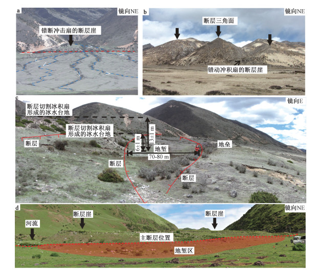
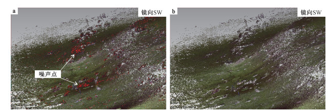
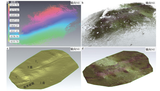
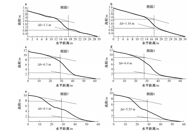
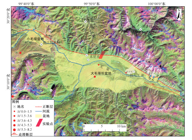
受地壳内部持续运动和沉积、风化等自然动力及人类生产与生活活动影响,活断层微地貌形态往往比较复杂,传统测量方法较难快速、高效地获取大范围内精细化的活断层微地貌形态,激光雷达扫描技术的出现和发展为活断层微地貌的精细化与定量化研究提供了新的技术手段。以川西理塘毛垭坝盆地北缘的正断层崖为研究对象,利用地面LiDAR获取活断层微地貌高精度点云后,经过点云配准、滤波、重采样和三角构网处理后,建立了0.05 m分辨率的数字高程模型和真彩色三维模型,在此基础上分析了断层崖地貌特征,并获取了正断层错动两期最新地貌面的精确垂直位错量。研究结果表明,地面LiDAR技术是精细测量活断层微地貌形态和量化相关地貌特征参数的有效手段,提高了活断层微地貌形态测量的精度和认识水平。
Abstract:The micro-geomorphologic geometry of active fault is often complex due to the natural dynamics, such as high degree of sedimentation and erosion, and man-made activities. It is difficult for traditional measurement methods to quickly and efficiently obtain the high-precision geomorphological geometry of fault scarp and to acquire fault displacement in a large scale. Light Detection And Ranging (LiDAR) provides a new technology for the quantitative study of the micro-geomorphologic geometry of active fault. In this study, the high-precision point cloud data of micro-geomorphologic geometry of the fault scarp are obtained by the terrestrial LiDAR on the Maoyaba fault. After the registration, filter, resample and irregular triangular mesh modeling processing of the point cloud data, the 0.05 m high-resolution DEM and the true color three-dimensional model are generated. On this basis, the geomorphic features of the fault scarp are analyzed, and the vertical displacements of two landforms produced by the latest two periods of normal faulting are obtained. The results show that the terrestrial LiDAR technology is an effective method to accurately measure the micro-geomorphic morphology of active fault and to quantify the relevant geomorphic characteristic parameters, which improves the precision and understanding level of the micro-geomorphologic geometry of active fault.
-
Key words:
- Maoyaba fault /
- point cloud /
- fault scarp /
- DEM /
- vertical displacement
-

-
ARROWSMITH J R, ZIELKE O, 2009. Tectonic geomorphology of the San Andreas Fault zone from high resolution topography: an example from the Cholame segment[J]. Geomorphology, 113(1-2): 70-81. doi: 10.1016/j.geomorph.2009.01.002
BAI Y J, NI H Y, GE H, 2019. Advances in research on the geohazard effect of active faults on the southeastern margin of the Tibetan Plateau[J]. Journal of Geomechanics, 25(6): 1116-1128. (in Chinese with English abstract) http://www.researchgate.net/publication/316645347_Research_on_the_geohazard_effect_of_active_fault_on_the_eastern_margin_of_the_Tibetan_Plateau
CANDELA T, RENARD F, 2012. Segment linkage process at the origin of slip surface roughness: Evidence from the Dixie Valley fault[J]. Journal of Structural Geology, 45: 87-100. doi: 10.1016/j.jsg.2012.06.003
CHEVALIER M L, LELOUP P H, REPLUMAZ A, et al., 2016. Tectonic-geomorphology of the Litang fault system, SE Tibetan Plateau, and implication for regional seismic hazard[J]. Tectonophysics, 682: 278-292. doi: 10.1016/j.tecto.2016.05.039
FU B H, YOSHIKI N, DONG Y F, et al., 2008. Generation of 3-Dimensional perspective satellite imagery and its application on Quaternary geomorphological analysis[J]. Quaternary Sciences, 28(2): 189-196. (in Chinese with English abstract) http://www.oalib.com/paper/1571240
GOLD P O, COWGILL E S, KREYLOS O, et al., 2012. A terrestrial lidar-based workflow for determining three-dimensional slip vectors and associated uncertainties[J]. Geosphere, 8(2): 431-442. doi: 10.1130/GES00714.1
GOLD P O, OSKIN M E, ELLIOTT A J, et al., 2013. Coseismic slip variation assessed from terrestrial lidar scans of the El Mayor-Cucapah surface rupture[J]. Earth & Planetary Science Letters, 366: 151-162. http://www.sciencedirect.com/science/article/pii/S0012821X13000642
HE H L, WEI Z Y, DENSMORE A, 2016. Quantitative morphology of bedrock fault surfaces and identification of paleo-earthquakes[J]. Tectonophysics, 693: 22-31. doi: 10.1016/j.tecto.2016.09.032
KANG S, ZHANG J F, CUI X F, et al., 2017. Offset landform caused by active fault based on high precision terrestrial LiDAR data: a case study of the Lenglongling active fault zone[J]. Earthquake, 37(3): 61-71. (in Chinese with English abstract) http://adsabs.harvard.edu/abs/2016AGUFM.T23B2927J
KAYEN R, PACK R T, BAY J, et al., 2006. Terrestrial-LIDAR visualization of surface and structural deformations of the 2004 Niigata Ken Chuetsu, Japan, earthquake[J]. Earthquake Spectra, 22: 147-162. doi: 10.1193/1.2173020
LI Z F, LIU J, SHAO Y X, et al., 2016. Tecto-geomorphic analysis and selection of trench sites along Haiyuan fault in Songshan site based on high-resolution airborne LiDAR data[J]. Geological Bulletin of China, (1): 104-116. (in Chinese with English abstract) http://www.researchgate.net/publication/301555431_Tecto-geomorphic_analysis_and_selection_of_trench_sites_along_Haiyuan_fault_in_Songshan_site_based_on_high-resolution_airbone_LiDAR_data
LIU J, CHEN T, ZHANG P Z, et al., 2013. Illuminating the active Haiyuan Fault, China by airborne light detection and ranging[J]. Chinese Science Bulletin, 58(1): 41-45. (in Chinese with English abstract) doi: 10.1360/972012-1526
LIU Y P, LIANG H, CHEN F F, 2016. Application of high resolution airborne LiDAR in Xiaojiang active tectonics and geological disaster study[J]. Journal of Geomechanics, 22(3): 747-759. (in Chinese with English abstract) http://en.cnki.com.cn/Article_en/CJFDTOTAL-DZLX201603028.htm
MA D, WU Z H, LI J C, et al., 2014. Geometric distribution and the Quaternary activity of Litang active fault zone based on remote sensing[J]. Acta Geologica Sinica, 88(8): 1417-1435. (in Chinese with English abstract) http://javascript:void(0)
MA H C, 2011. Review on applications of LiDAR mapping technology to geosciences[J]. Earth Science: Journal of China University of Geosciences, 36(2): 347-354. (in Chinese with English abstract) http://www.researchgate.net/publication/288134417_Review_on_applications_of_LiDAR_mapping_technology_to_geosciences
MA H C, YAO C J, ZHANG S D, 2008. Some technical issues of airborne LIDAR system applied to Wenchuan Earthquake relief works[J]. Journal of Remote Sensing, 12(6): 925-932. (in Chinese with English abstract) http://www.oalib.com/paper/1470202
MA X X, WU Z H, LI J C, 2016. LiDAR technology and its application and prospect in geological environment[J]. Journal of Geomechanics, 22(1): 93-103. (in Chinese with English abstract) http://en.cnki.com.cn/Article_en/CJFDTOTAL-DZLX201601010.htm
OSKIN M E, ARROWWSMITH J R, CORONA A H, et al., 2012. Near-field deformation from the El Mayor-Cucapah earthquake revealed by differential LiDAR[J]. Science, 335(6069): 702-705. doi: 10.1126/science.1213778
REN Z K, CHEN T, ZHANG H P, et al., 2014. LiDAR survey in active tectonics studies: an introduction and overview[J]. Acta Geologica Sinica, 88(6): 1196-1207. (in Chinese with English abstract) http://en.cnki.com.cn/Article_en/CJFDTOTAL-DZXE201406019.htm
REN Z K, ZIELKE O, YU J X, 2018. Active tectonics in 4D high-resolution[J]. Journal of Structural Geology, 117: 264-271. doi: 10.1016/j.jsg.2018.09.015
RENARD F, VOISIN C, MARSAN D, et al., 2006. High resolution 3D laser scanner measurements of a strike-slip fault quantify its morphological anisotropy at all scales[J]. Geophysical Research Letters, 33(4): L04305. http://onlinelibrary.wiley.com/doi/10.1029/2005GL025038/full
SHE J X, CHENG D X, LIU F, et al., 2018. Application of airborne LiDAR technology in geological disaster investigation: Taking the Jiuzhaigou MS7.0 earthquake in Sichuan province as an example[J]. Earthquake Research in China, 34(3): 435-444. (in Chinese with English abstract) http://en.cnki.com.cn/Article_en/CJFDTotal-ZGZD201803005.htm
TAN X B, XU X W, YU G H, et al., 2015. The application of 3D laser scanning technology in surface rupture survey of the normal fault: an example of the 2008 Ms7.3 Yutian earthquake[J]. Technology for Earthquake Disaster Prevention, 10(3): 491-500. (in Chinese with English abstract) http://en.cnki.com.cn/Article_en/CJFDTOTAL-ZZFY201503003.htm
TANG Y, 2019. Measurement of the spatial scale of fracture dislocation through high-resolution remote sensing images[J]. China Earthquake Engineering Journal, 41(5): 1274-1279, 1373. (in Chinese with English abstract) http://en.cnki.com.cn/Article_en/CJFDTotal-ZBDZ201905023.htm
WEI Z Y, HE H L, SU P, et al., 2019. Investigating paleoseismicity using fault scarp morphology of the Dushanzi Reverse Fault in the northern Tian Shan, China[J]. Geomorphology, 327: 542-553. doi: 10.1016/j.geomorph.2018.11.025
WEI Z Y, HE H L, GAO W, et al., 2014. Experimental study on geologic mapping of active tectonics based on LiDAR data: A case of Dushanzi anticline-reverse fault zone in Xinjiang[J]. Seismology and Geology, 36(3): 794-813. (in Chinese with English abstract) http://www.researchgate.net/publication/281925237_Experimental_study_on_geologic_mapping_of_active_tectonics_based_on_LiDAR_data_-_A_case_of_Dushanzi_anticline-reverse_fault_zone_in_Xinjiang
WEI Z Y, SHI F, GAO X, et al., 2010. Topographic characteristics of rupture surface associated with Wenchuan earthquake[J]. Earth Science Frontiers, 17(5): 53-66. (in Chinese with English abstract) http://d.wanfangdata.com.cn/Periodical/dxqy201005005
WILKINSON M, ROBERTS G P, MCCAFFREY K, et al., 2015. Slip distributions on active normal faults measured from LiDAR and field mapping of geomorphic offsets: an example from L'Aquila, Italy, and implications for modelling seismic moment release[J]. Geomorphology, 237: 130-141. doi: 10.1016/j.geomorph.2014.04.026
WILKINSON M W, MCCAFFREY K J W, ROBERTS G P, et al., 2012. Distribution and magnitude of post-seismic deformation of the 2009 L'Aquila earthquake (M6.3) surface rupture measured using repeat terrestrial laser scanning[J]. Geophysical Journal International, 189(2): 911-922. doi: 10.1111/j.1365-246X.2012.05418.x
WU Z H, LONG C X, FAN T Y, et al., 2015. The arc rotational-shear active tectonic system on the southeastern margin of Tibetan Plateau and its dynamic characteristics and mechanism[J]. Geological Bulletin of China, 34(1): 1-31. (in Chinese with English abstract) http://en.cnki.com.cn/Article_en/CJFDTOTAL-ZQYD201501002.htm
XIAO K Z, TONG H M, 2020. Progress on strike-slip fault research and its significance[J]. Journal of Geomechanics, 26(2): 151-166. (in Chinese with English abstract)
XU X W, WEN X Z, YU G H, et al., 2015. Average slip rate, earthquake rupturing segmentation and recurrence behavior on the Litang fault zone, western Sichuan province[J]. Science in China Series D: Earth Sciences, 48(8): 1183-1196.
YUAN X X, WANG X Q, DOU A X, et al., 2012. Terrestrial LiDAR-based 3D modeling analysis of surface rupture caused by Yushu earthquake[J]. Seismology and Geology, 34(1): 39-46. (in Chinese with English abstract) http://www.en.cnki.com.cn/Article_en/CJFDTOTAL-DZDZ201201007.htm
ZHAGN J F, JIANG W L, TIAN T, et al., 2016. High resolution remote sensing application research in active fault surveying[J]. Acta Seismologica Sinica, 38(3): 386-398. (in Chinese with English abstract) http://en.cnki.com.cn/Article_en/CJFDTOTAL-DZXB201603006.htm
ZHENG W J, LEI Q Y, DU P, et al., 2015. 3-D laser scanner (LiDAR): A new technology for acquiring high precision palaeoearthquake trench information[J]. Seismology and Geology, 37(1): 232-241. (in Chinese with English abstract) http://en.cnki.com.cn/Article_en/CJFDTotal-DZDZ201501018.htm
ZHOU C J, WU Z H, ZHANG K Q, et al., 2015. New chronological constraint on the co-seismic surface rupture segments associated with the Litang Fault[J]. Seismology and Geology, 37(2): 455-467. (in Chinese with English abstract) http://www.en.cnki.com.cn/Article_en/CJFDTOTAL-DZDZ201502009.htm
ZHOU R J, CHEN G X, LI Y, et al., 2015. Research on active faults in Litang-Batang region, western Sichuan province, and the seismogenic structures of the 1989 Batang M6.7 earthquake swarm[J]. Seismology and Geology, 27(1): 31-43. (in Chinese with English abstract)
白永健, 倪化勇, 葛华, 2019. 青藏高原东南缘活动断裂地质灾害效应研究现状[J]. 地质力学学报, 25(6): 1116-1128. https://journal.geomech.ac.cn/ch/reader/view_abstract.aspx?flag=1&file_no=20190613&journal_id=dzlxxb
付碧宏, 二宫芳树, 董彦芳, 等, 2008. 三维卫星遥感图像生成技术及其在第四纪构造地貌研究中的应用[J]. 第四纪研究, 28(2): 189-196. https://www.cnki.com.cn/Article/CJFDTOTAL-DSJJ200802002.htm
康帅, 张景发, 崔效峰, 等, 2017. 基于高精度地基LiDAR技术的活动断层错断地貌研究: 以冷龙岭活动断裂带为例[J]. 地震, 37(3): 61-71. https://www.cnki.com.cn/Article/CJFDTOTAL-DIZN201703007.htm
李占飞, 刘静, 邵延秀, 等, 2016. 基于LiDAR的海原断裂松山段断错地貌分析与古地震探槽选址实例[J]. 地质通报, (1): 104-116. https://www.cnki.com.cn/Article/CJFDTOTAL-ZQYD201601009.htm
刘静, 陈涛, 张培震, 等, 2013. 机载激光雷达扫描揭示海原断裂带微地貌的精细结构[J]. 科学通报, 58(1): 41-45. https://www.cnki.com.cn/Article/CJFDTOTAL-KXTB201301003.htm
刘宇平, 梁虹, 陈菲菲, 2016. 高精度机载LiDAR在小江活动构造和地质灾害研究中的应用[J]. 地质力学学报, 22(3): 747-759. https://journal.geomech.ac.cn/ch/reader/view_abstract.aspx?flag=1&file_no=20160328&journal_id=dzlxxb
马丹, 吴中海, 李家存, 等, 2014. 川西理塘断裂带的空间展布与第四纪左旋走滑活动的遥感影像标志[J]. 地质学报, 88(8): 1417-1435. https://www.cnki.com.cn/Article/CJFDTOTAL-DZXE201408005.htm
马洪超, 2011. 激光雷达测量技术在地学中的若干应用[J]. 地球科学: 中国地质大学学报, 36(2): 347-354. https://www.cnki.com.cn/Article/CJFDTOTAL-DQKX201102022.htm
马洪超, 姚春静, 张生德, 2008. 机载激光雷达在汶川地震应急响应中的若干关键问题探讨[J]. 遥感学报, 12(6): 925-932. https://www.cnki.com.cn/Article/CJFDTOTAL-YGXB200806014.htm
马晓雪, 吴中海, 李家存, 2016. LiDAR技术在地质环境中的主要应用与展望[J]. 地质力学学报, 22(1): 93-103. https://journal.geomech.ac.cn/ch/reader/view_abstract.aspx?flag=1&file_no=20160110&journal_id=dzlxxb
任治坤, 陈涛, 张会平, 等, 2014. LiDAR技术在活动构造研究中的应用[J]. 地质学报, 88(6): 1196-1207. https://www.cnki.com.cn/Article/CJFDTOTAL-DZXE201406019.htm
佘金星, 程多祥, 刘飞, 等, 2018. 机载激光雷达技术在地质灾害调查中的应用: 以四川九寨沟7.0级地震为例[J]. 中国地震, 34(3): 435-444. https://www.cnki.com.cn/Article/CJFDTOTAL-ZGZD201803005.htm
谭锡斌, 徐锡伟, 于贵华, 等, 2015. 三维激光扫描技术在正断层型地表破裂调查中的应用: 以2008Ms7.3于田地震为例[J]. 震灾防御技术, 10(3): 491-500. https://www.cnki.com.cn/Article/CJFDTOTAL-ZZFY201503003.htm
唐毅, 2019. 改进高分辨率遥感影像测量断裂错动空间尺度的探讨研究[J]. 地震工程学报, 41(5): 1274-1279, 1373. https://www.cnki.com.cn/Article/CJFDTOTAL-ZBDZ201905023.htm
魏占玉, 何宏林, 高伟, 等, 2014. 基于LiDAR数据开展活动断层填图的实验研究: 以新疆独山子背斜-逆冲断裂带为例[J]. 地震地质, 36(3): 794-813. https://www.cnki.com.cn/Article/CJFDTOTAL-DZDZ201403020.htm
魏占玉, 石峰, 高翔, 等, 2010. 汶川地震地表破裂面形貌特征[J]. 地学前缘, 17(5): 53-66. https://www.cnki.com.cn/Article/CJFDTOTAL-DXQY201005005.htm
吴中海, 龙长兴, 范桃园, 等, 2015. 青藏高原东南缘弧形旋扭活动构造体系及其动力学特征与机制[J]. 地质通报, 34(1): 1-31. https://www.cnki.com.cn/Article/CJFDTOTAL-ZQYD201501002.htm
肖坤泽, 童亨茂, 2020. 走滑断层研究进展及启示[J]. 地质力学学报, 26(2): 151-166. https://journal.geomech.ac.cn/ch/reader/view_abstract.aspx?flag=1&file_no=20200201&journal_id=dzlxxb
徐锡伟, 闻学泽, 于贵华, 等, 2015. 川西理塘断裂带平均滑动速率、地震破裂分段与复发特征[J]. 中国科学D辑: 地球科学, 35(6): 540-551. https://www.cnki.com.cn/Article/CJFDTOTAL-JDXK200506006.htm
袁小祥, 王晓青, 窦爱霞, 等, 2012. 基于地面LIDAR玉树地震地表破裂的三维建模分析[J]. 地震地质, 34(1): 39-46. https://www.cnki.com.cn/Article/CJFDTOTAL-DZDZ201201007.htm
张景发, 姜文亮, 田甜, 等, 2016. 活动断裂调查中的高分辨率遥感技术应用方法研究[J]. 地震学报, 38(3): 386-398. https://www.cnki.com.cn/Article/CJFDTOTAL-DZXB201603006.htm
郑文俊, 雷启云, 杜鹏, 等, 2015. 激光雷达(LiDAR): 获取高精度古地震探槽信息的一种新技术[J]. 地震地质, 37(1): 232-241. https://www.cnki.com.cn/Article/CJFDTOTAL-DZDZ201501018.htm
周春景, 吴中海, 张克旗, 等, 2015. 川西理塘活动断裂最新同震地表破裂形成时代与震级的重新厘定[J]. 地震地质, 37(2): 455-467. https://www.cnki.com.cn/Article/CJFDTOTAL-DZDZ201502009.htm
周荣军, 陈国星, 李勇, 等, 2015. 四川西部理塘-巴塘地区的活动断裂与1989年巴塘6.7级震群发震构造研究[J]. 地震地质, 27(1): 31-43. https://www.cnki.com.cn/Article/CJFDTOTAL-DZDZ200501003.htm
-


 下载:
下载:
