

Development history and activity characteristics of typical debris flows in the Grand Bend of the Yarlung Zangbo River since the Holocene
-
摘要:
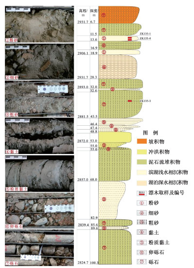
雅鲁藏布江大拐弯附近晚更新世末次冰期—全新世发育多期次泥石流, 组合形成了现代大规模扇形堆积体。以派镇蹦嘎沟泥石流为例, 采用地面调查、钻孔及14C测年等方法, 研究泥石流形成年代序列、堆积深度、冲出范围等特征, 分析结果表明: 现代蹦嘎沟依然有小规模的支沟泥石流发育且广泛堆积于沟道内, 现存堆积扇区域尚未发现泥石流堆积; 距今8500年左右为蹦噶沟全新世泥石流活跃期, 单期次累积堆积深度约10.9 m; 滨湖浅水相沉积(河流相)形成的浅灰色粉细砂中的两处碳样表明雅鲁藏布江现代河床在40~100年左右沉积深度约0.4 m, 年平均沉积速率4~10 mm; 海拔2906.1~2896.7 m及2849.4~2848.2 m处钻孔依次揭露厚度为9.4 m和1.2 m饼状青灰色粉质黏土, 推测发生两次堵江事件。上述结果可为该区域全新世以来泥石流活动性特征研究提供参考。
Abstract:Multi-period debris flows have been developed in the last glacial period of the late Pleistocene-Holocene near the Grand Bend of the Yarlung Zangbo River in southeast Xizang, which combined to form a modern large-scale fan-shaped accumulation. The debris flows in the Bangga gully, Pai Town, were explored by ground survey, borehole, and 14C dating methods to investigate the chronological sequence of formation, accumulation depth, and outrush range. The analysis results show that there are still small-scale debris flows in the tributaries of the Bengga gully, and they are widely accumulated in the channel, but no debris flow accumulation has been found in the existing accumulation fan area. The Holocene debris flows in the Bunga gully were active around 8500 years ago, and the cumulative accumulation depth of a single period is about 10.9 m. The two carbon samples in the light gray silt sand formed by the shallow lake facies (fluvial facies) show that the modern riverbed of the Yarlung Zangbo River was deposited at a depth of about 0.4 m in 40 to 100 years, and the annual average deposition rate was about 4~10 mm. The boreholes at 2906.1~2896.7 m and 2849.4~2848.2 m above sea level reveal a thickness of 9.4 m and 1.2 m cake-like bluish-gray clay in turn. It is assumed that two river-blocking events occurred. The above results could provide a reference for the study of the debris flow activity characteristics since the Holocene in this region.
-

-
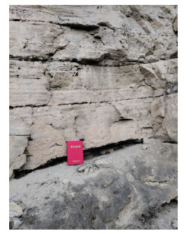
表 1 测年取样样品及其位置统计表
Table 1. Statistical table of the samples for dating and their locations
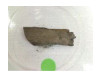
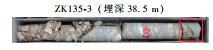
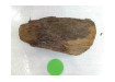
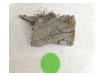
样品位置及取样编号 样品照片 


 下载: 导出CSV
表 2 漂木样品测年结果
Table 2. Dating results of the driftwood samples
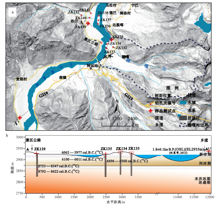
样品编号 埋深/m 放射性碳年龄 公历校正 测年概率/% ZK135-1 12.6 7120+/-30 a B.P. 6062—5977 cal.B.C. 76.0 5948—5919 cal.B.C. 19.4 ZK135-4 13.0 7220+/-30 a B.P. 6100—6011 cal.B.C. 76.7 6219—6135 cal.B.C. 18.7 ZK135-3 38.5 7810+/-30 a B.P. 6696—6568 cal.B.C. 93.4 ZK139-2 61.0 9370+/-40 a B.P. 8753—8547 cal.B.C. 93.7 ZK139-1 61.8 9420+/-30 a B.P. 8792—8622 cal.B.C. 95.4
下载: 导出CSV
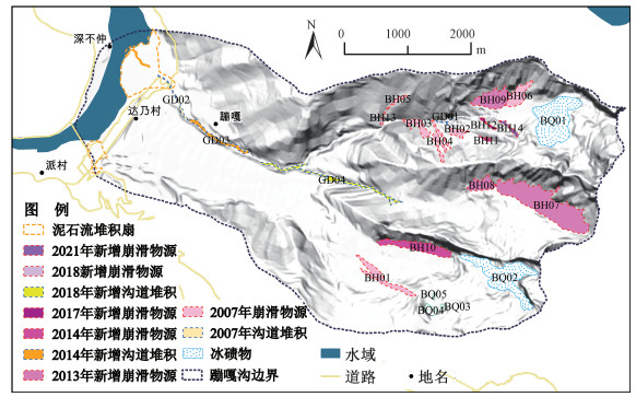
表 3 蹦嘎沟泥石流物源分布及时间变化特征
Table 3. Source distribution and temporal variation characteristics of the sources in the Bengga gully
编号 类型 面积/m2 厚度/m 体积/×104 m3 影像日期 BH01 崩滑物源 95734 4.21 40.29 2007-9-17 BH02 崩滑物源 26254 3.13 8.21 2007-9-17 BH03 崩滑物源 44733 3.54 15.81 2007-9-17 BH04 崩滑物源 51883 3.66 18.98 2007-9-17 BH05 崩滑物源 12012 2.61 3.14 2007-9-17 BH06 崩滑物源 76095 3.99 30.39 2007-9-17 BH07 崩滑物源 483453 6.10 294.98 2013-10-9 BH08 崩滑物源 67118 3.88 26.04 2013-10-9 BH09 崩滑物源 126595 4.49 56.81 2013-10-9 BH10 崩滑物源 134525 4.55 61.21 2014-11-8 BH11 崩滑物源 5820 2.21 1.29 2017-12-4 BH12 崩滑物源 8658 2.43 2.10 2017-12-4 BH13 崩滑物源 7208 2.33 1.68 2018-12-26 BH14 崩滑物源 15242 2.76 4.21 2021-1-23 GD01 沟道堆积 4149 2.05 0.85 2007-9-17 GD02 沟道堆积 16190 2.80 4.53 2007-9-17 GD03 沟道堆积 47282 3.58 16.93 2014-11-8 GD04 沟道堆积 71395 3.94 28.09 2018-12-26
下载: 导出CSV
-
BERNHARDT H, REISS D, HIESINGER H, et al., 2017. Debris flow recurrence periods and multi-temporal observations of colluvial fan evolution in central Spitsbergen (Svalbard)[J]. Geomorphology, 296: 132-141. doi: 10.1016/j.geomorph.2017.08.049
CHEN J, CUI Z J, 2014. Development features of the Early Pleistocene debris-flow deposits at the Baima Mountain Pass, Yunnan Province and their paleoclimatic and tectonic significance[J]. Arid Land Geography, 37(2): 203-211. (in Chinese with English abstract)
CHENG Z L, TIAN J C, ZHANG Z B, et al., 2009. Analysis on environment of disasters resulting from river blockage in Xizang[J]. Journal of Catastrophology, 24(1): 26-30. (in Chinese with English abstract) doi: 10.3969/j.issn.1000-811X.2009.01.006
HAN L M, 2018. Geological hazard characteristics and risk assessment of Brahmaputra from Wolong to Zhibai stream segment[D]. Chengdu: Chengdu University of Technology.
HOYOS N, MONSALVE O, BERGER G W, et al., 2015. A climatic trigger for catastrophic Pleistocene-Holocene debris flows in the eastern Andean Cordillera of Colombia[J]. Journal of Quaternary Science, 30(3): 258-270. doi: 10.1002/jqs.2779
HUANG C C, GUO Y Q, ZHANG Y Z, et al., 2019. Holocene sedimentary stratigraphy and pre-historical catastrophes over the Lajia Ruins within the Guanting Basin in Qinghai province of China[J]. Scientia Sinica Terrae, 49(2): 434-455. (in Chinese) doi: 10.1360/N072017-00378
JABOYEDOFF M, CARREA D, DERRON M H, et al., 2020. A review of methods used to estimate initial landslide failure surface depths and volumes[J]. Engineering Geology, 267: 105478. doi: 10.1016/j.enggeo.2020.105478
LEONG E C, CHENG Z Y, 2022. A geometry-modelling method to estimate landslide volume from source area[J]. Landslides, 19(8): 1971-1985. doi: 10.1007/s10346-022-01864-0
LI C P, WANG P, QIAN D, et al., 2015. Ages of the recent two episodes of glacially dammed lakes along the upstream of the Yarlung Zangbo Gorge[J]. Seismology and Geology, 37(4): 1136-1146. (in Chinese with English abstract) doi: 10.3969/j.issn.0253-4967.2015.04.016
LI Y H, ZHANG X Y, CUI Z J, et al, 2002. Periodic coupling of debris flow active periods and climate periods during Quaternary[J]. Quaternary Sciences, 22(4): 340-348. (in Chinese with English abstract) doi: 10.3321/j.issn:1001-7410.2002.04.006
LI Y J, MENG X M, STEVENS T, et al., 2021. Distinct periods of fan aggradation and incision for tributary valleys of different sizes along the Bailong River, eastern margin of the Xizang Plateau[J]. Geomorphology, 373: 107490. doi: 10.1016/j.geomorph.2020.107490
LIU X W, 2015. Analysis of the meteorological and hydrological charateristics in the Yarlung Zangbo River Basins[D]. Beijing: Tsinghua University. (in Chinese with English abstract)
LIU Y P, MONTGOMERY D R, HALLET B, et al., 2006. Quaternary glacier blocking events at the entrance of Yarlung Zangbo great canyon, Southeast Xizang[J]. Quaternary Sciences, 26(1): 52-62. (in Chinese with English abstract) doi: 10.3321/j.issn:1001-7410.2006.01.007
MALIK I, TIE Y B, OWCZAREK P, et al., 2013. Human-planted alder trees as a protection against debris flows (a dendrochronological study from the Moxi Basin, Southwestern China)[J]. Geochronometria, 40(3): 208-216. doi: 10.2478/s13386-013-0113-x
MONTGOMERY D R, HALLET B, LIU Y P, et al., 2004. Evidence for Holocene megafloods down the Tsangpo River gorge, southeastern Xizang[J] Quaternary Research, 62(2): 201-207. doi: 10.1016/j.yqres.2004.06.008
MARC O, HOVIUS N, MEUNIER P, et al, 2015. Transient changes of landslide rates after earthquakes[J]. Geology, 43(10): 883-886. doi: 10.1130/G36961.1
ŠILHÁN K, TICHAVSKY R, 2016. Recent increase in debris flow activity in the Tatras Mountains: Results of a regional dendrogeomorphic reconstruction[J]. CATENA, 143: 221-231. doi: 10.1016/j.catena.2016.04.015
TANG C, ZHU J, DING J, et al, 2011. Catastrophic debris flows triggered by a 14 August 2010 rainfall at the epicenter of the Wenchuan earthquake[J]. Landslides, 8: 485-497. doi: 10.1007/s10346-011-0269-5
TIE Y B, MALIK I, OWCZAREK P, 2014. Dendrochronological Dating of debris flow historical events in high mountain area: Take Daozao debris flow as an example[J]. Mountain Research, 32(2): 226-232. (in Chinese with English abstract) doi: 10.3969/j.issn.1008-2786.2014.02.013
WANG H Y, TONG K Y, HU G, et al., 2021. Dam and megafloods at the first bend of the Yangtze River since the Last Glacial Maximum[J]. Geomorphology, 373: 107491. doi: 10.1016/j.geomorph.2020.107491
WANG P, WANG H Y, HU G, et al., 2021. A preliminary study on the development of dammed paleolakes in the Yarlung Tsangpo River Basin, southeastern Xizang[J]. Earth Science Frontiers, 28(2): 35-45. (in Chinese with English abstract)
YANG H, CUI C G, WANG X F, et al. 2019. Research progresses of precipitation variation over the Yarlung Zangbo River basin under global climate warming[J]. Torrential Rain and Disasters, 38(6): 565-575.
ZHANG P Q, LIU X H, KONG P, 2008. Evidence for glacial movement since last glacial period in the Great Canyon, Yarlung Zangbo, SE Xizang and its tectono-environmental implications[J]. Chinese Journal of Geology, 43(3): 588-602. (in Chinese with English abstract) doi: 10.3321/j.issn:0563-5020.2008.03.013
ZHANG P Q, GAO M X, LEI Y L, et al, 2009. Quantitative terrain analysis of the great canyon region of Yalungzangbo River, Xizang and discussion of its origin[J]. Journal of Earth Science: 34(4): 595-603.
ZHAO Q Y, WEI M J, SONG B, et al., 2013. TL evidence of debris flow developments in the Late Pleistocene of Yunnan Jiangjia Valley Basin[J]. Nuclear Electronics & Detection Technology, 33(7): 865-868. (in Chinese with English abstract) doi: 10.3969/j.issn.0258-0934.2013.07.021
ZHAO W J, 2015. The Formation characteristics and geomorphical evolution of the landslides and debris flow fans in Guide basin, the upper reaches of the Yellow River[D]. Beijing: China University of Geosciences (Beijing). (in Chinese with English abstract)
ZHU S, 2012. River Landform and geological environment evolution in the Yarlung Zangbo River Vally[D]. Beijing: Chinese Academy of Geological Sciences. (in Chinese with English abstract)
ZHU S, WU Z H, ZHAO X T, et al, 2013. The age of glacial dammed lakes in the Yarlung Zangbo River Grand Bend during Late Quaternary by OSL[J]. Acta Geoscientia Sinica, 34(2): 246-250. (in Chinese with English abstract)
陈剑, 崔之久, 2014. 云南白马雪山垭口早更新世泥石流的发育特征及其古气候和构造意义[J]. 干旱区地理, 37(2): 203-211. https://www.cnki.com.cn/Article/CJFDTOTAL-GHDL201402001.htm
程尊兰, 田金昌, 张正波, 等, 2009. 西藏江河堵溃灾害及成灾环境分析[J]. 灾害学, 24(1): 26-30. doi: 10.3969/j.issn.1000-811X.2009.01.006
黄春长, 郭永强, 张玉柱, 等, 2019. 青海官亭盆地喇家遗址全新世地层序列与史前灾难研究[J]. 中国科学: 地球科学, 49(2): 434-455. https://www.cnki.com.cn/Article/CJFDTOTAL-JDXK201902008.htm
韩立明, 2018. 雅鲁藏布江卧龙至直白河段地质灾害发育特征及危险性评价[D]. 成都: 成都理工大学.
李翠平, 王萍, 钱达, 等, 2015. 雅鲁藏布江大峡谷入口河段最近两期古堰塞湖事件的年龄[J]. 地震地质, 37(4): 1136-1146. doi: 10.3969/j.issn.0253-4967.2015.04.016
刘湘伟, 2015. 雅鲁藏布江流域水文气象特性分析[D]. 北京: 清华大学.
李永化, 张小咏, 崔之久, 等, 2002. 第四纪泥石流活动期与气候期的阶段性耦合过程[J]. 第四纪研究, 22(4): 340-348. doi: 10.3321/j.issn:1001-7410.2002.04.006
刘宇平, MONTGOMERY D R, HALLET B, 等, 2006. 西藏东南雅鲁藏布大峡谷入口处第四纪多次冰川阻江事件[J]. 第四纪研究, 26(1): 52-62. doi: 10.3321/j.issn:1001-7410.2006.01.007
铁永波, MALIK I, OWCZAREK P, 2014. 树木年代学在高寒山区泥石流历史事件重建中的应用: 以磨西河流域倒灶沟为例[J]. 山地学报, 32(2): 226-232. doi: 10.3969/j.issn.1008-2786.2014.02.013
王萍, 王慧颖, 胡钢, 等, 2021. 雅鲁藏布江流域古堰塞湖群的发育及其地质意义初探[J]. 地学前缘, 28(2): 35-45. https://www.cnki.com.cn/Article/CJFDTOTAL-DXQY202102004.htm
杨浩, 崔春光, 王晓芳, 等, 2019. 气候变暖背景下雅鲁藏布江流域降水变化研究进展[J]. 暴雨灾害, 38(6): 565-575. https://www.cnki.com.cn/Article/CJFDTOTAL-HBQX201906001.htm
张沛全, 刘小汉, 孔屏, 2008. 雅鲁藏布江大拐弯地区末次冰期以来的冰川活动证据及其构造-环境意义[J]. 地质科学, 43(3): 588-602. https://www.cnki.com.cn/Article/CJFDTOTAL-DZKX200803014.htm
张沛全, 高明星, 雷永良, 等, 2009. 西藏雅鲁藏布江大拐弯地区量化地貌特征及其成因[J]. 地球科学(中国地质大学学报): 34(4): 595-603. https://www.cnki.com.cn/Article/CJFDTOTAL-DQKX200904005.htm
赵秋月, 魏明建, 宋波, 等, 2013. 晚更新世云南蒋家沟流域泥石流发育的热释光证据[J]. 核电子学与探测技术, 33(7): 865-868. https://www.cnki.com.cn/Article/CJFDTOTAL-HERE201307020.htm
赵无忌, 2015. 黄河上游贵德盆地滑坡泥石流扇发育特征及地貌演化过程[D]. 北京: 中国地质大学(北京).
祝嵩, 2012. 雅鲁藏布江河谷地貌与地质环境演化[D]. 北京: 中国地质科学院.
祝嵩, 吴珍汉, 赵希涛, 等, 2013. 用OSL方法确定雅鲁藏布江大拐弯第四纪晚期冰川堰塞湖年龄[J]. 地球学报, 34(2): 246-250. https://www.cnki.com.cn/Article/CJFDTOTAL-DQXB201302017.htm
-


图(11)
表(3)
计量
- 文章访问数: 1801
- PDF下载数: 125
- 施引文献: 0