Geological Hazard Susceptibility Evaluation Based on AHP and GIS in Zhouqu County, Gansu
-
摘要:
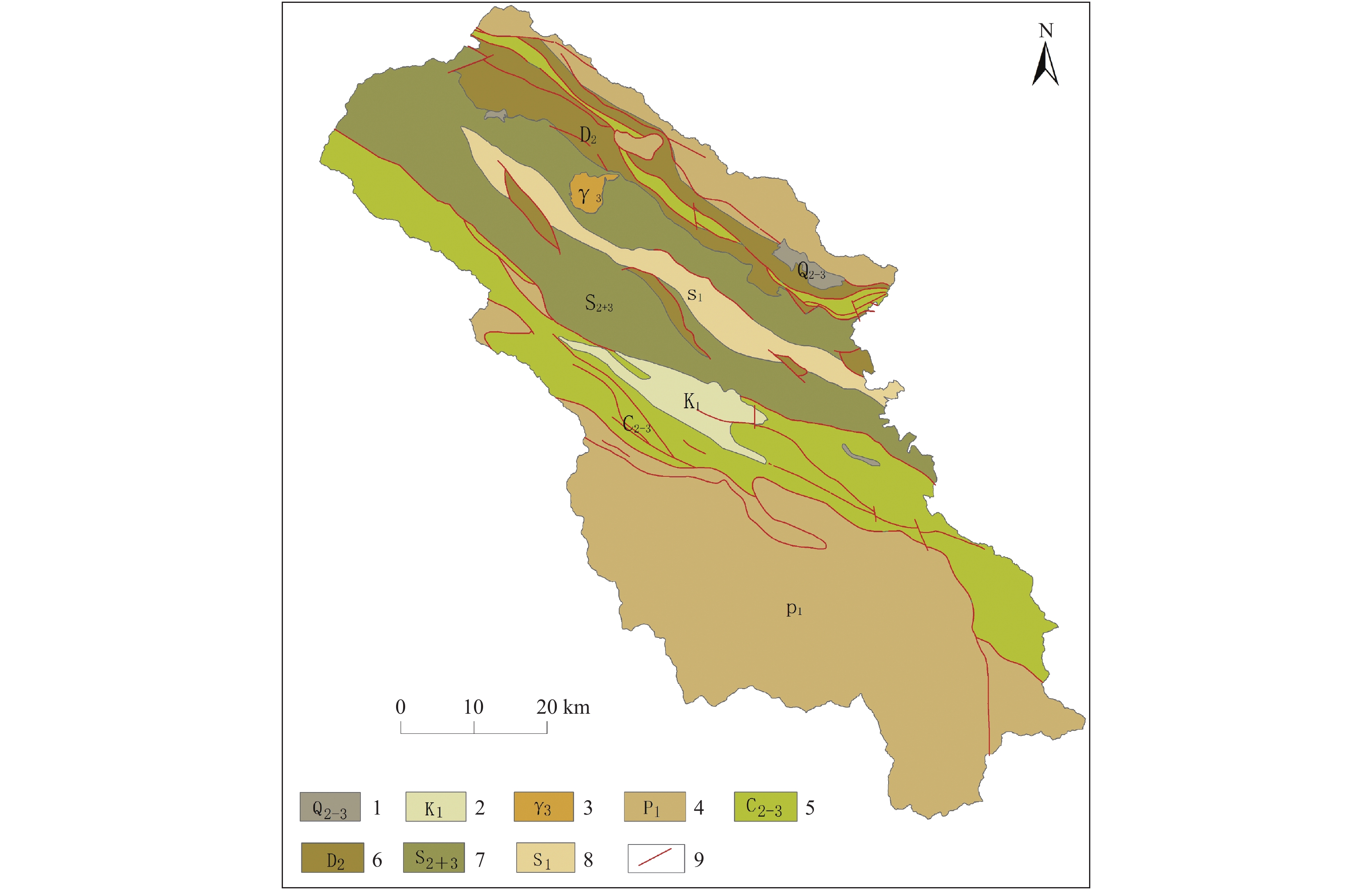
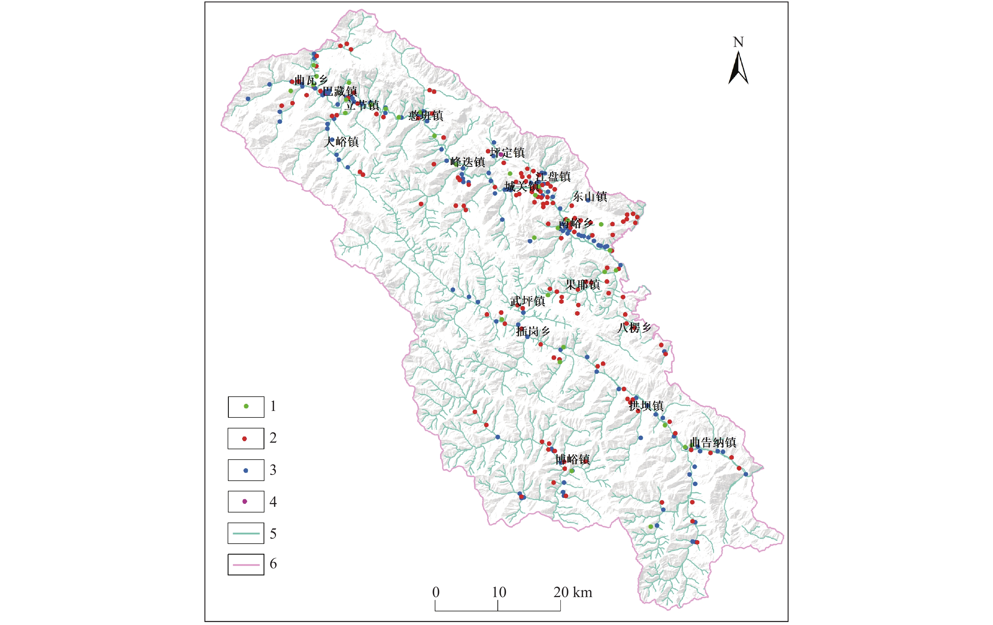
舟曲县是中国罕见的滑坡、泥石流地质灾害高发区,其防灾减灾工作具有一定的挑战性。依托舟曲县1∶50 000地质灾害风险调查工作,深入分析孕灾地质条件,选取地质灾害频率比、地质灾害面积模数比、地质灾害体积模数比、坡度、坡度变化率、坡形、切割深度、沟壑密度、岩土体类型、地质构造、植被指数11个评价因子,建立AHP评价模型,确定各因子权重,运用GIS平台综合评价舟曲县地质灾害易发性。结果显示:舟曲县地质灾害极高易发区和高易发区的面积分别为68.98 km2、390.9 km2,分别占县域总面积的2.29%和12.97%,主要分布在人员财产集中的白龙江流域、石门沟流域、拱坝河流域中下游和博峪河流域舟曲段中部区域;中易发区、低易发区对应的面积分别为1166.21 km2和1387.76 km2。研究成果为舟曲县城镇整体规划和地质灾害防治提供决策参考。
Abstract:Zhouqu County is a rare national area with a high incidence of landslides and debris flows, and its disaster prevention and mitigation work is challenging. Relying on the 1∶50 000 geological disaster risk survey work in Zhouqu County, we deeply analyze the geological conditions for disaster, select 11 evaluation factors of geological disaster frequency ratio, geological disaster area modulus ratio, geological disaster volume modulus ratio, slope, slope change rate, slope shape, cutting depth, gully density, rock and soil type, faults, vegetation index, establish an evaluation model using analytic hierarchy process (AHP), determine the weight assignment of each factor, and use The GIS platform was used to comprehensively evaluate the vulnerability of geological disasters in Zhouqu County.. The results show that the areas of extremely high-prone and high-prone areas are 68.98 km2 and 390.9 km2 respectively in Zhouqu County, Gongba River Basin, middle area of Zhouqu section of Boyu River Basin , where people and properties are concentrated. The corresponding areas of the middle-prone and low-prone areas are 1166.21 km2 and 1387.76 km2, respectively. The research results provide references for the overall planning of Zhouqu County and geological disaster prevention and control.
-

-
表 1 崩塌、滑坡对应坡形统计表
Table 1. Slope shape statistics corresponding to collapse and landslide
序号 坡面形态 灾体数量
(个)所占比例
(%)灾害类型 滑坡 崩塌 1 凸形 40 23.3 35 5 2 凹形 54 31.4 54 0 3 直线形 53 30.8 26 27 4 阶梯型 25 14.5 25 0 合计 172 100.0 140 32 表 2 不同坡度区间崩塌滑坡发生概率统计表
Table 2. Statistics of collapse and landslide occurrence in different slope gradient intervals
序号 坡度区
间(°)灾害总数 灾害类型 滑坡 崩塌 数量(个) 比率(%) 数量(个) 比率(%) 数量(个) 比率(%) 1 0~10 0 0.0 0 0.0 0 0.0 2 11~20 26 15.1 26 18.6 0 0.0 3 21~30 42 24.4 42 30.0 0 0.0 4 31~40 45 26.2 43 30.7 2 6.3 5 41~50 27 15.7 19 13.6 8 25.0 6 51~60 13 7.6 10 7.1 3 9.4 7 61~70 7 4.1 0 0.0 7 21.9 8 71~80 7 4.1 0 0.0 7 21.9 9 81~90 5 2.9 0 0.0 5 15.6 合 计 172 100 140 100 32 100 表 3 不同坡高区间崩塌滑坡发生概率统计表
Table 3. Statistics of collapse and landslide occurrence in different slope height intervals
序号 坡高区间
(m)数量(个)
比率(%)灾害类型 滑坡 崩塌 数量(个) 比率(%) 数量(个) 比率(%) 1 0~50 29 16.9 18 12.9 11 34.4 2 51~100 31 18.0 23 16.4 8 25.0 3 101~200 41 23.8 35 25.0 6 18.8 4 201~300 19 11.0 16 11.4 3 9.4 5 301~400 23 13.4 21 15.0 2 6.3 6 401~500 9 5.2 9 6.4 0 0.0 7 501~600 8 4.7 8 5.7 0 0.0 8 601~700 6 3.5 5 3.6 1 3.1 9 >700 6 3.5 5 3.6 1 3.1 合 计 172 100.0 140 100.0 32 100.0 表 4 泥石流主沟纵坡统计表
Table 4. Statistics of longitudinal slope of main gully of debris flow
序号 主沟纵坡(‰) 泥石流数量(条) 比例 泥石流类型 易发程度 (%) 泥石流 水石流 高易发 中易发 低易发 1 <100 13 10.5 13 0 0 10 3 2 100~200 37 29.8 37 0 0 37 0 3 200~300 29 23.4 29 0 0 27 2 4 300~400 16 12.9 16 0 1 13 2 5 400~500 12 9.7 2 0 1 10 1 6 500~600 11 8.9 10 1 0 9 2 7 600~700 4 3.2 3 1 0 1 3 8 700~800 1 0.8 1 0 0 0 1 9 >800 1 0.8 1 0 0 0 1 合计 124 100.0 112 2 2 107 15 表 5 泥石流山坡坡度统计表
Table 5. Statistics of debris flow in different slope ranges
序号 坡度区间(°) 泥石流数量(条) 所占比例 泥石流类型 易发程度 (%) 泥石流 水石流 高易发 中易发 低易发 1 <25 2 1.6 2 0 0 2 0 2 26~35 46 37.1 45 1 1 44 1 3 36~45 54 43.5 54 0 1 46 7 4 46~55 15 12.1 14 1 11 4 5 >55 7 5.6 7 0 0 4 3 总计 124 100 122 2 2 107 15 表 6 泥石流流域面积统计表
Table 6. Statistics of debris flow in different watershed areas
序号 流域面积
(km2)泥石流数量
(条)比例
(%)泥石流类型 易发程度 泥石流 水石流 高易发 中易发 低易发 1 <1 40 32.3 38 2 1 31 8 2 1~5 37 29.8 37 0 0 34 3 3 5~10 13 10.5 13 0 1 11 1 4 10~20 9 7.3 9 0 0 8 1 5 20~50 16 12.9 16 0 0 14 2 6 50~100 8 6.5 8 0 0 8 0 7 >100 1 0.8 1 0 0 1 0 合计 124 100 122 2 2 107 15 表 7 泥石流相对高差统计表
Table 7. Statistics of debris flow in different relative elevation ranges
序号 相对高差
(m)泥石流数量
(条)比例
(%)泥石流类型 易发程度 泥石流 水石流 高易发 中易发 低易发 1 <200 4 3.2 4 0 0 4 0 2 200~500 17 13.7 16 1 0 15 2 3 500~1000 42 33.9 41 1 1 33 8 4 1000~1500 31 25.0 31 0 1 27 3 5 1500~2000 21 16.9 21 0 0 20 1 6 >2000 9 7.3 9 0 0 8 1 合计 124 100 122 2 2 107 15 表 8 数据来源一览表
Table 8. List of data sources
基础数据 数据来源 数据格式 说明 地质数据 1∶50 000孕灾地质条件图 SHP 提取地质构造、岩土体类型等 DEM数据 地理空间数据云 TIFF 30 m×30 m分辨率,用于提取地形地貌相关数据 遥感数据 ETM+ TIFF 2019年4月数据,用于计算NDVI 隐患点数据 舟曲县1:50 000地质灾害风险调查评价成果 SHP 用于构建发育因子指标 表 9 孕灾地质条件因子量化一览表
Table 9. Quantitative list of disaster-pregnant geological conditions
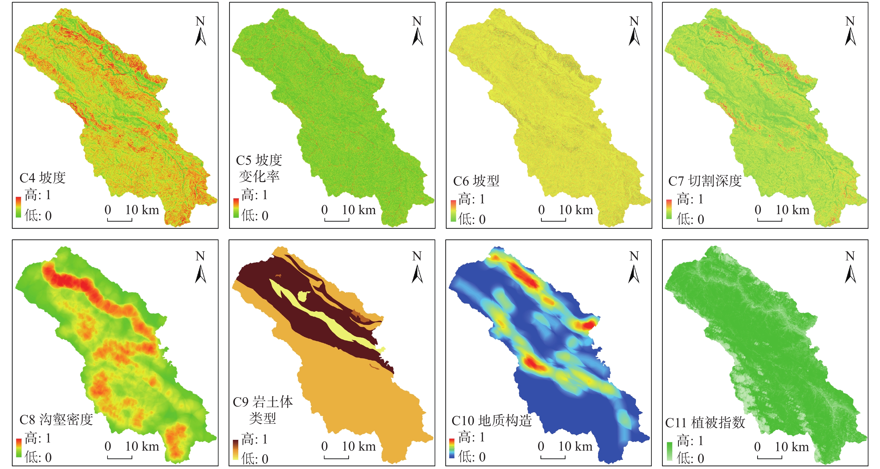
序号 分类 孕灾因子 数据源 指标量化过程(意义) 1 地形地貌数据 坡度 DEM
(30 m×
30 m)DEM数据提取。研究区内崩滑灾害所在斜坡坡度区间为10°~70°,本次评价将坡度上限的易发程度定义为1,坡度下限的易发程度定义为0,进行归一化处理。 2 坡度变化率 DEM数据提取。反映坡度变化情况,与斜坡拉张应力区的分布呈正相关,其变化越大,说明斜坡内部应力也随之变大,稳定性差。 3 坡形 DEM数据提取。可用地表曲率表征,以零为界,大于或等于零表明是直线/凸型斜坡,小于零表明是凹型/阶梯型坡斜坡。 4 切割深度 DEM数据提取。可用高程差表示,即平均值与最小值之差,表明区域地形地貌的起伏度以及沟谷的发育程度。 5 沟壑密度 DEM数据提取。衡量地表破碎程度,可用流域内水文网的长度表征。 6 岩土类型数据 岩土体类型 1:50000孕灾地质条件图 岩土体类型的矢量数据。根据岩土体的工程地质特性,易发性由高到低分别赋予4~1,最后栅格化并归一。 7 构造数据 地质构造 利用断层矢量数据。以区内第四纪以来发育的活动断裂为基准线,利用线密度分析工具,以3km为搜索半径进行分析。 8 环境变量数据 植被覆盖率 ETM+ 利用2019年4月ETM+遥感数据,计算求取植被指数NDVI。 表 10 地质灾害易发性统计表
Table 10. Statistics of geohazards susceptibility
易发等级 指数区间 面积(km2) 总面积占比(%) 区内灾害点数量(个) 频率比 低易发区 0.0599~0.2915 1387.76 46.05 17 0.123 中易发区 0.2915~0.4199 1166.21 38.70 62 0.535 高易发区 0.4199~0.6993 390.9 12.97 149 3.842 极高易发区 0.6993~0.7019 68.97 2.29 71 10.369 -
[1] 白永健, 李明辉, 王东辉, 等. 金沙江中游巴塘县地质灾害发育特征及成灾规律分析[J]. 中国地质灾害与防治学报, 2014, 25(02): 103-109
BAI Yongjian, LI Minghui, WANG Donghui, et al. Characteristics and disastrous rule research of geohazards in batang county, the middle reaches of Jinsha river [J]. The Chinese Journal of Geological Hazard and Control, 2014, 25(02): 103-109.
[2] 白永健, 铁永波, 倪化勇, 等. 鲜水河流域地质灾害时空分布规律及孕灾环境研究[J]. 灾害学, 2014, 29(4): 69-75 doi: 10.3969/j.issn.1000-811X.2014.04.014
BAI Yongjian, TIE Yongbo, NI Huayong, et al. Temporal-Spatial Distribution and Environment Pregnant of Geohazards in Xianshui River of Sichuan, China [J]. Journal of Catastrophology, 2014, 29( 4): 69-75. doi: 10.3969/j.issn.1000-811X.2014.04.014
[3] 陈世昌, 丛凯, 王玉飞, 等. 舟曲县1: 50000地质灾害风险调查评价[R]. 兰州: 甘肃省地质环境监测院, 2021.
[4] 方然可, 刘艳辉, 苏永超, 等. 基于逻辑回归的四川青川县区域滑坡灾害预警模型[J]. 水文地质工程地质, 2021, 48(01): 181-187
FANG Ranke, LIU Yanhui, SU Yongchao, et al. A early warning model of regional landslide in Qingchuan County, Sichuan Province based on logistic regression [J]. Hydrogeology&Engineering geology, 2021, 48(01): 181-187.
[5] 黄润秋, 许向宁, 唐川, 等. 地质环境评价与地质灾害管理[M]. 北京: 科学出版社, 2008
HUANG Runqiu, XU Xiangning, TANG Chuan, et al. Geological Environmental Assessment and Geological Hazard Management[M]. Beijing: Science Press, 2008.
[6] 贾丽娜, 梁收运. 基于最优组合赋权法的华池县地质灾害易发性评价[J]. 地质灾害与环境保护, 2018, 29(04): 61-67 doi: 10.3969/j.issn.1006-4362.2018.04.012
JIA Lina, LIANG Shouyun. Assessment of geohazards susceptibility for Huachi County by the optimal combined weight method [J]. Journal of Geological Hazards and Environment Preservation, 2018, 29(04): 61-67. doi: 10.3969/j.issn.1006-4362.2018.04.012
[7] 贾俊, 毛伊敏, 孟晓捷, 等. 深度随机森林和随机森林算法的滑坡易发性评价对比以汉中市略阳县为例[J]. 西北地质, 2023, 56(3): 239−249.
JIA Jun, MAO Yimin, MENG Xiaojie, et al. Comparison of Landslide Susceptibility Evaluation by Deep Random Forest and Random Forest Model: A Case Study of Lueyang County, Hanzhong City[J]. Northwestern Geology, 2023, 56(3): 239−249.
[8] 乐琪浪, 王洪德, 高幼龙, 等. 三峡库区望霞危岩体孕灾地质环境条件分析[J]. 地球学报, 2015, 36(02): 204-212 doi: 10.3975/cagsb.2015.02.09
LE Qilang, WANG Hongde, GAO Youlong, et al. An Analysis of Disaster-pregnant Geological Environment Conditions of the Wangxia Unstable Rock Mass in the Three Gorges Reservoir [J]. Acta Geoscientica Sinica, 2015, 36(02): 204-212. doi: 10.3975/cagsb.2015.02.09
[9] 刘传正, 陈春利. 中国地质灾害成因分析[J]. 地质论评, 2020, 66(05): 1334-1348
LIU Chuanzheng, CHEN Chunli. Research on the origins of geological disasters in China[J]. Geological Review, 2020, 66(05): 1334-1348.
[10] 罗路广, 裴向军, 崔圣华, 等. 九寨沟地震滑坡易发性评价因子组合选取研究[J]. 岩石力学与工程学报, 2021, 40(11): 2306-2319 doi: 10.13722/j.cnki.jrme.2021.0198
LUO Luguang, PEI Xiangjun, CUI Shenghua, et al. Combined selection of susceptibility assessment factors for Jiuzhaigou earthquake-induced landslides[J]. Chinese Journal of Rock Mechanics and Engineering, 2021, 40(11): 2306-2319. doi: 10.13722/j.cnki.jrme.2021.0198
[11] 罗路广, 裴向军, 黄润秋, 等. GIS支持下CF与Logistic回归模型耦合的九寨沟景区滑坡易发性评价[J]. 工程地质学报, 2021, 29(02): 526-535 doi: 10.13544/j.cnki.jeg.2019-202
LUO Luguang, Pei Xiangjun, Huang Runqiu, et al. Landslide susceptibility assessment in Jiuzhaigou scenic area with GIS based on certainty factor and Logistic regression model[J]. Journal of Engineering Geology, 2021, 29(02): 526-535. doi: 10.13544/j.cnki.jeg.2019-202
[12] 孟晓捷, 张新社, 曾庆铭, 等. 基于加权信息量法的黄土滑坡易发性评价——以1: 5万天水市麦积幅为例[J]. 西北地质, 2022, 55(2): 249−259.
MENG Xiaojie, ZHANG Xinshe, ZENG Qingming, et al. The Susceptibility Evaluation of Loess Landslide Based on Weighted Information Value Method: Taking 1: 50 000 Map of Maiji District of Tianshui City As an Example[J]. Northwestern Geology, 2022, 55(2): 249−259.
[13] 彭建兵. 中国活动构造与环境灾害研究中的若干重大问题[J]. 工程地质学报, 2006, (01): 5-12 doi: 10.3969/j.issn.1004-9665.2006.01.002
PENG Jianbing. Some important problems to be addressed in reseach of active tectonics and enviromental disasters in China[J]. Journal of Engineering Geology, 2006, (01): 5-12. doi: 10.3969/j.issn.1004-9665.2006.01.002
[14] 孙萍萍, 张茂省, 程秀娟, 等. 黄土高原地质灾害发生规律[J]. 山地学报, 2019, 37(05): 737-746 doi: 10.16089/j.cnki.1008-2786.000464
SUN Pingping, ZHANG Maosheng, CHENG Xiujuan, et al. On the Regularity of Geological Hazards on the Loess Plateau in China[J]. Mountain Research, 2019, 37(05): 737-746. doi: 10.16089/j.cnki.1008-2786.000464
[15] 王高峰, 高幼龙, 王洪德, 等. 基于图幅调查的六盘山镇滑坡易发性分析[J]. 科学技术与工程, 2017, 17(36): 22-29 doi: 10.3969/j.issn.1671-1815.2017.36.004
WANG Gaofeng, GAO Youlong, WANG Hongde, et al. Analyses on Landslide Susceptibility of Liupan Shan Town Based on Map Sheet Survey[J]. Science Technology and Engineering, 2017, 17(36): 22-29. doi: 10.3969/j.issn.1671-1815.2017.36.004
[16] 王高峰, 郭宁, 邓兵, 等. 不同组合模型区域滑坡易发性及精度分析[J]. 西北地质, 2021, 54(02): 259-272
WANG Gaofeng, GUO Ning, DENG Bing, et al. Analysis of Landslide Susceptibility and Accuracy in Different Combination Models[J]. Northwestern Geology, 2021, 54(02): 259-272.
[17] 王高峰, 王爱军, 田运涛, 等. 基于图幅调查的六盘山镇孕灾地质条件分析[J]. 水土保持研究, 2016, 23(05): 364-369 doi: 10.13869/j.cnki.rswc.2016.05.050
WANG Gaofeng, WANG Aijun, TIAN Yuntao, et al. Analysis on Disaster-Pregnant Geological Environment of Liupanshan Town Based on Map Sheet Survey[J]. Research of Soil and Water Conservation, 2016, 23(05): 364-369. doi: 10.13869/j.cnki.rswc.2016.05.050
[18] 汪美华, 李勇, 裴叶青. 甘肃临夏盆地韩集北山滑坡群致灾特征与稳定性评价[J]. 地质通报, 2023, 42(2−3): 460−468.
WANG Meihua, LI Yong, PEI Yeqing. Disaster characteristics and stability evaluation of the Hanjin Beishan landslide group in Linxia Basin, Gansu Province[J]. Geological Bulletin of China, 2023, 42(2−3): 460−468.
[19] 吴树仁, 石菊松, 张春山, 等. 地质灾害风险评估技术指南初论[J]. 地质通报, 2009, 28(8): 995-1005 doi: 10.3969/j.issn.1671-2552.2009.08.001
WU Shuren, SHI Jusong, ZHANG Chunshan, et al. Preliminary discussion on technical guideline for geohazard risk assessment[J]. Geological Bulletin of China, 2009, 28(8): 995-1005 doi: 10.3969/j.issn.1671-2552.2009.08.001
[20] 熊德清, 崔笑烽. 喜马拉雅山脉地震带主要地质灾害与地形地貌关系——以西藏日喀则地区为例[J]. 地质通报, 2021, 40(11): 1967-1980 doi: 10.12097/j.issn.1671-2552.2021.11.014
XIONG Deqing, CUI Xiaofeng. The relationship between main geological hazard and topography in the Himalayan seismic belt: A case study in the Xigaze area, Xizang [J]. Geological Bulletin of China, 2021, 40(11): 1967-1980. doi: 10.12097/j.issn.1671-2552.2021.11.014
[21] 许冲, 戴福初, 姚鑫, 等. GIS支持下基于层次分析法的汶川地震区滑坡易发性评价[J]. 岩石力学与工程学报, 2009, 28(S2): 3978-3985 doi: 10.3321/j.issn:1000-6915.2009.z2.100
XU Chong, DAI Fuchu, YAO Xin, et al. GIS-Based Landslide susceptibility assessment using analytical hierarchy process in Wenchuan earthquake region[J]. Chinese Journal of Rock Mechanics and Engineering, 2009, 28(S2): 3978-3985. doi: 10.3321/j.issn:1000-6915.2009.z2.100
[22] 许英姿, 卢玉南, 李东阳, 等. 基于GIS和信息量模型的广西花岗岩分布区滑坡易发性评价[J]. 工程地质学报, 2016, 24(04): 693-703
XU Yingzi, LU Yunan, LI Dongyang, et al. GIS and information model based landslide susceptibility assessment in granite area of Guangxi province[J]. Journal of Engineering Geology, 2016, 24(04): 693-703.
[23] 张俊, 殷坤龙, 王佳佳, 等. 三峡库区万州区滑坡灾害易发性评价研究[J]. 岩石力学与工程学报, 2016, 35(02): 284-296
ZHANG Jun, YIN Kunlong, WANG Jiajia, et al. Evaluation of landslide susceptibility for Wanzhou district of Three Gorges Reservoir[J]. Chinese Journal of Rock Mechanics and Engineering, 2016, 35(02): 284-296.
[24] 张林梵, 王佳运, 张茂省, 等. 基于BP神经网络的区域滑坡易发性评价[J]. 西北地质, 2022, 55(2): 260-270
ZHANG Linfan, WANG Jiayun, ZHANG Maosheng, et al. Evaluation of Regional Landslide Susceptibility Assessment Based on BP Neural Network[J]. Northwestern Geology, 2022, 55(2): 260-270.
[25] 张玘恺, 凌斯祥, 李晓宁, 等. 九寨沟县滑坡灾害易发性快速评估模型对比研究[J]. 石力学与工程学报, 2020, 39(08): 1595-1610
ZHANG Qikai, LING Sixiang, LI Xiaoyu, et al. Comparison of landslide susceptibility mapping rapid assessment models in Jiuzhaigou County, Sichuan province, China [J]. Chinese Journal of Rock Mechanics and Engineering, 2020, 39(08): 1595-1610.
[26] 张文居, 孟陆波, 李磊, 等. 汶马高速公路斜坡地质灾害分布规律及演化模式[J]. 成都理工大学学报(自然科学版), 2022, 49(2): 196−203.
ZHANG Wenjun, MENG Lubo, LI Lei, et al. Distribution law and evolution model of geological hazards on the slope of Wenchuan-Maerkang expressway, Sichuan, China[J], Journal of Chengdu University of Technology (Science & Technology Edition), 2022, 49(2): 196−203.
[27] 张永双, 郭长宝, 姚鑫, 等. 青藏高原东缘活动断裂地质灾害效应研究[J]. 地球学报, 2016, 37(03): 277-286 doi: 10.3975/cagsb.2016.03.03
ZHANG Yongshuang, GUO Changbao, YAO Xin, et al. Research on the Geohazard Effect of Active Fault on the Eastern Margin of the Xizang Plateau[J]. Acta Geoscientica Sinica, 2016, 37(03): 277-286. doi: 10.3975/cagsb.2016.03.03
[28] 赵东亮, 兰措卓玛, 侯光良, 等. 青海省河湟谷地地质灾害易发性评价[J]. 地质力学学报, 2021, 27(01): 83-95 doi: 10.12090/j.issn.1006-6616.2021.27.01.009
ZHAO Dongliang, LANCUO Zhouma, HOU Guangliang, et al. Assessment of geological disaster susceptibility in the Hehuang Valley of Qinghai Province[J]. Journal of geomechanics, 2021, 27(01): 83-95. doi: 10.12090/j.issn.1006-6616.2021.27.01.009
[29] AYALEW L, YAMAGISHI H. The application of GIS-based logistic regression for landslide susceptibility mapping in the Kakuda-Yahiko Mountains, Central Japan[J]. Geomorphology, 2005, 65(1-2): 15-31. doi: 10.1016/j.geomorph.2004.06.010
[30] CAPPARELLI G, VERSACE P. FLAIR and SUSHI: two mathematical models for early warning of landslide induced by rainfall[J]. Landslides, 2011, 8(1): 67-79. doi: 10.1007/s10346-010-0228-6
-


 下载:
下载:


