

-
摘要:
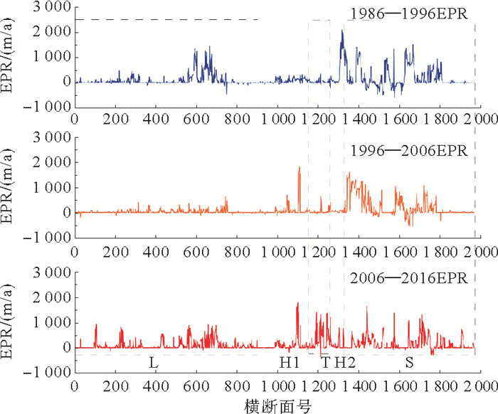
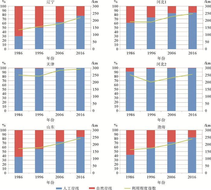
渤海已成为中国社会经济发展中广受关注的重点区域。通过对比不同时期渤海岸线长度、面积等要素,重点分析了渤海海岸线30年来时空变化特征。研究结果表明,30年间,渤海海岸带岸线以向海扩张为主,海岸线长度总体呈增加趋势,由1986年2 370.82 km到2016年3 437.59 km;人工岸线占比快速增加,其中最多的为围堤岸线;2006—2016年间各岸段终点速率变化最大,天津段和山东段的海岸线一直保持较高的终点变化速率,并以海岸线前进为主要趋势,表明天津、山东的经济活动范围不断向海洋拓展。研究期间,渤海各岸段的岸线利用程度有不同幅度的提高,总体表现为海岸工程建设、围海造地,人类的活动对岸线的影响已经占据主体地位,围海造地是海岸线变迁的主要驱动因素。
Abstract:The Bohai Sea is a key area in China in terms of socio-economic development. In this paper, we studied coastline changes, such as the changes in length and area in different periods for the past 30 years. The results of this study show that over the past 30 years, the coastline of the Bohai Sea was mainly moving towards offshore. The length of the coastline was increasing in general and the total length of the coastline increased from 2 258.81 km in 1960 to 3 437.59 km in 2016. Artificial coastline, in particular the embankment coastline, increases rapidly. The largest changes in the end rate of coastline are found in the period of 2006-2016. The Tianjin section and Shandong section of coastline are the ones which kept highest end point rates in the period of 1986-2016 in a trend of advancing, due to the increase in human activities. Owing to the coastal construction and land reclamation during the studked period, the utilization of coastline in each coast section of the Bohai Sea is also increased tocertain extent. The influence of human activities, in particular land reclamation, played critical rolesin the changes of coastline.
-
Key words:
- Bohai /
- coastline change /
- human activities /
- environmental impact
-

-
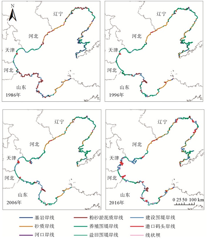
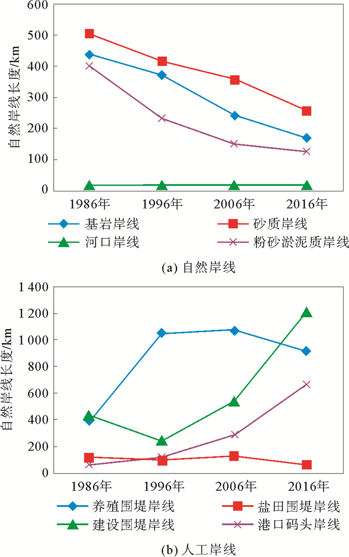
表 1 1986—2016年渤海不同海岸类型变化
Table 1. Changes in coast types in the Bohai Sea during 1986—2016
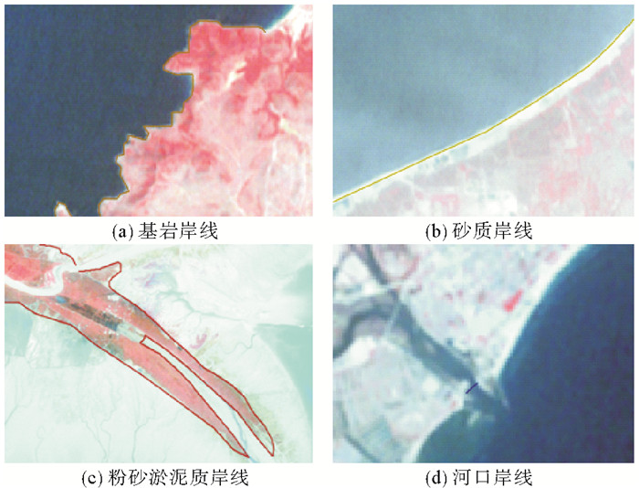
长度/km 百分比/% 1986年 1996年 2006年 2016年 1986年 1996年 2006年 2016年 自然岸线 基岩岸线 437.34 371.57 241.85 169.80 18.45 14.57 8.65 4.94 砂质岸线 503.41 414.19 357.85 256.15 21.23 16.24 12.80 7.45 河口岸线 18.05 17.97 17.86 17.97 0.76 0.70 0.64 0.52 粉砂淤泥质岸线 400.12 232.61 150.59 126.03 16.88 9.12 5.39 3.67 小计 1 358.91 1 036.34 768.14 569.95 57.32 40.64 27.47 16.58 人工岸线 养殖围堤岸线 396.17 1 049.25 1 073.42 916.61 16.71 41.15 38.39 26.66 盐田围堤岸线 115.78 101.47 129.31 66.75 4.88 3.98 4.62 1.94 建设围堤岸线 432.63 244.12 537.90 1 216.02 18.25 9.57 19.24 35.37 港口码头岸线 67.33 118.78 287.14 668.26 2.84 4.66 10.27 19.44 小计 1 011.91 1 513.62 2 027.77 2 867.64 42.68 59.36 72.53 83.42 总计 2 370.82 2 549.95 2 795.91 3 437.59 100.00 100.00 100.00 100.00  下载: 导出CSV
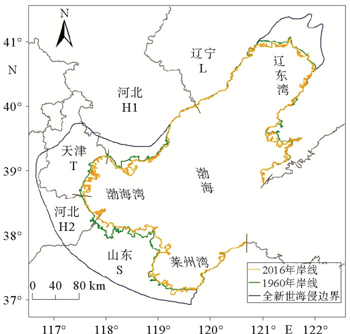
表 2 1960—2016年各岸段海岸线长度变化信息
Table 2. Changes in coastline length of each coastal section during the period of 1960-1986
长度/km 长度变化/km 1960年 1986年 1996年 2006年 2016年 1960—1986年 1986—1996年 1996—2006年 2006—2016年 辽宁段 987.76 1 147.52 1 237.40 1 262.21 1 529.49 159.76 89.88 24.81 267.28 河北1段 346.41 295.79 355.23 465.51 502.39 -50.62 59.44 110.28 36.88 天津段 125.89 143.16 158.63 183.71 326.39 17.27 15.47 25.08 142.68 河北2段 82.79 81.98 57.07 70.60 120.49 -0.81 -24.91 13.53 49.89 山东段 715.96 702.37 741.61 813.89 958.83 -13.59 39.24 72.28 144.94 总计 2 258.81 2 370.82 2 549.95 2 795.92 3 437.59 112.01 179.12 245.98 641.67
下载: 导出CSV
表 3 1960—2016年渤海各岸段海岸线面积变化信息
Table 3. Coastal area change of different sections along the coast of Bohai Sea during the period of 1960-1986
前进面积/km2 后退面积/km2 1960—1986年 1986—1996年 1996—2006年 2006—2016年 1960—1986年 1986—1996年 1996—2006年 2006—2016年 辽宁段 261.76 450.46 185.35 612.31 100.35 13.17 15.64 13.66 河北1段 248.30 143.73 90.09 285.74 32.06 3.85 7.33 5.36 天津段 105.01 26.31 62.92 293.13 1.71 4.57 1.70 2.11 河北2段 10.28 88.63 36.32 81.11 45.79 0.64 0.16 0.55 山东段 721.74 713.03 738.56 583.95 817.17 143.43 61.17 30.22 总计 1 347.09 1 422.16 1 113.24 1 856.24 997.08 165.67 86.00 51.90
下载: 导出CSV
表 4 渤海不同岸段人力作用强度指数
Table 4. Human activity intensity index in different sections of the Bohai Sea
岸线类型 自然岸线 养殖盐田区岸线 工程岸线 基岩岸线 砂质岸线 粉砂淤泥质岸线 河口岸线 养殖围堤岸线 盐田围堤岸线 建设围堤岸线 港口码头岸线 人力作用强度指数 1 1 1 1 2 2 3 3
下载: 导出CSV
表 5 1986—2016年渤海海岸线及渤海总面积变化信息
Table 5. Changes in coastline and total area of the Bohai Sea during the past 30 years
1986年 1996年 2006年 2016年 自然岸线长度/km 1 358.91 1 036.34 768.14 569.95 自然岸线占比/% 57.32 40.64 27.47 16.58 人工岸线长度/km 1 011.91 1 513.62 2 027.77 2 867.64 人工岸线占比(% 42.68 59.36 72.53 83.42 岸线长度/km 2 370.82 2 549.95 2 795.91 3 437.59 渤海总面积/km2 79 498.76 78 248.55 77 233.97 75 437.33
下载: 导出CSV
-
[1] 毋亭, 侯西勇.海岸线变化研究综述[J].生态学报, 2016, 36(4):1170-1182. http://d.old.wanfangdata.com.cn/Periodical/stxb201604030
[2] Liu H, Jezek K C. Automated extraction of coastline from satellite imagery by integrating Canny edge detection and locally adaptive thresholding methods[J].International Journal of Remote Sensing, 2004, 25(5): 937-958. doi: 10.1080/0143116031000139890
[3] Tian B, Wu W, Yang Z, et al. Drivers, trends, and potential impacts of long-term coastal reclamation in China from 1985 to 2010[J]. Estuarine Coastal & Shelf Science, 2016, 170:83-90. http://www.wanfangdata.com.cn/details/detail.do?_type=perio&id=7db6a52d693ab282763a9d392abab410
[4] 刘亮.辽东湾、渤海湾、莱州湾三湾生态系统服务价值评估[J].生态经济, 2012(6):155-160. doi: 10.3969/j.issn.1671-4407.2012.06.034
[5] 马万栋, 吴传庆, 殷守敬, 等.环渤海围填海遥感监测及对策建议[J].环境与可持续发展, 2015(3):63-65. doi: 10.3969/j.issn.1673-288X.2015.03.015
[6] 李亚宁, 王倩, 郭佩芳, 等.近20a来渤海岸线演替及其开发利用策略[J].海洋湖沼通报, 2015(3):32-38. http://d.old.wanfangdata.com.cn/Periodical/hyhztb201503004
[7] 吴培强, 张杰, 马毅, 等. 2010—2015年环渤海海岸线时空变迁监测与分析[J].海洋科学进展, 2018, 36(1):128-138. doi: 10.3969/j.issn.1671-6647.2018.01.012
[8] 冯金良, 郑丽.海岸线分维的地质意义浅析[J].海洋地质与第四纪地质, 1997, 27(1):45-51. http://www.wanfangdata.com.cn/details/detail.do?_type=perio&id=QK199700255542
[9] Wang H, Shang Z W, Li J F, et al. Holocene shoreline changes and marine impacts on the muddy coast, western Bohai Bay, China[J]. Geological Bulletin of China, 2010, 29(5):627-640. http://www.wanfangdata.com.cn/details/detail.do?_type=perio&id=zgqydz201005001
[10] 申家双, 翟京生, 郭海涛.海岸线提取技术研究[J].海洋测绘, 2009, 29(6):74-77. doi: 10.3969/j.issn.1671-3044.2009.06.021
[11] 丁小迪.基于遥感的山东半岛海岸带环境变化研究[D].青岛: 中国海洋大学, 2015.
http://cdmd.cnki.com.cn/Article/CDMD-10423-1015713151.htm [12] 汪品先, 顾尚勇.下辽河平原的第四纪海进[M].北京:海洋出版社, 1980.
[13] 薛春汀. 7 000年来渤海西岸、南岸海岸线变迁[J].地理科学, 2009, 29(2):217-222. doi: 10.3969/j.issn.1000-0690.2009.02.012
[14] 张志恒.胶州湾海岸带利用现状与评价[D].青岛: 中国海洋大学, 2009.
http://d.wanfangdata.com.cn/Thesis/Y1502299 [15] 郑全安, 吴隆业, 张欣梅, 等.胶州湾遥感研究——Ⅰ.总水域面积和总岸线长度量算[J].海洋与湖沼, 1991, 22(3):193-199+297.
[16] 索安宁, 曹可, 马红伟, 等.海岸线分类体系探讨[J].地理科学, 2015, 35(7):933-937. http://www.wanfangdata.com.cn/details/detail.do?_type=perio&id=dlkx201507018
[17] 孙伟富, 马毅, 张杰, 等.不同类型海岸线遥感解译标志建立和提取方法研究[J].测绘通报, 2011(3):41-44. http://d.old.wanfangdata.com.cn/Periodical/chtb201103012
[18] 赵松龄, 杨光复, 苍树溪, 等.关于渤海湾西岸海相地层与海岸线问题[J].海洋与湖沼, 1978, 9(1):15-25. http://www.cnki.com.cn/Article/CJFDTotal-HYFZ197801001.htm
[19] 周万源.晚更新世以来渤海湾西岸海岸线的变迁[C]//中国地质科学院562综合大队文集(5), 1986-10, 北京: 地质出版社, 1986: 90-92.
http://cpfd.cnki.com.cn/Article/CPFDTOTAL-ZGDJ198610001009.htm [20] Lambeck K. Sea level change through the last glacial cycle[J]. Science, 2001, 292(5517):679-686. doi: 10.1126/science.1059549
[21] Wu T, Hou X, Xu X. Spatio-temporal characteristics of the mainland coastline utilization degree over the last 70years in China[J]. Ocean & Coastal Management, 2014, 98(98):150-157. http://www.wanfangdata.com.cn/details/detail.do?_type=perio&id=4d197cfb64acf487f9802f762f5ee50a
[22] 李静.河北省围填海演进过程分析与综合效益评价[D].石家庄: 河北师范大学, 2008.
http://d.wanfangdata.com.cn/Thesis/Y1254610 [23] Wang W, Liu H, Li Y, et al. Development and management of land reclamation in China[J]. Ocean & Coastal Management, 2014, 102:415-425. http://d.old.wanfangdata.com.cn/Periodical/zhonggtdkx201802013
[24] Tian B, Wu W, Yang Z, et al. Drivers, trends, and potential impacts of long-term coastal reclamation in China from 1985 to 2010[J]. Estuarine Coastal & Shelf Science, 2016, 170:83-90. http://www.wanfangdata.com.cn/details/detail.do?_type=perio&id=7db6a52d693ab282763a9d392abab410
[25] Meng W Q, Hu B B, He M X, et al.Temporal-spatial variation sand driving factors analysis of coastalreclamationinchina[J].Estuar Coast Shelf Sci, 2017, 191:39-49. doi: 10.1016/j.ecss.2017.04.008
[26] 侯庆志.渤海湾连片开发对于海岸滩涂动力环境及演变过程的影响研究[D].南京: 南京师范大学, 2013.
http://cdmd.cnki.com.cn/Article/CDMD-10319-1015529110.htm [27] 袁兴中, 陆健健.围垦对长江口南岸底栖动物群落结构及多样性的影响[J].生态学报, 2001, 21(10):1642-1647. doi: 10.3321/j.issn:1000-0933.2001.10.012
[28] Sato S, Azuma M. Ecological and paleoecological implications of the rapid increase and decrease of an introduced bivalve Potamocorbula, sp. after the construction of a reclamation dike in Isahaya Bay, western Kyushu, Japan[J]. Palaeogeography Palaeoclimatology Palaeoecology, 2002, 185(3):369-378. http://www.wanfangdata.com.cn/details/detail.do?_type=perio&id=f115f2848fe9e32d6d05efc11c65b178
-

图(7)
表(5)
计量
- 文章访问数: 712
- PDF下载数: 13
- 施引文献: 0