

THE STUDY OF CHANNEL SEDIMENT ARCHITECTURE AND EVOLUTION PATTERN OF RESERVOIR IN NIGER BASIN
-
摘要:
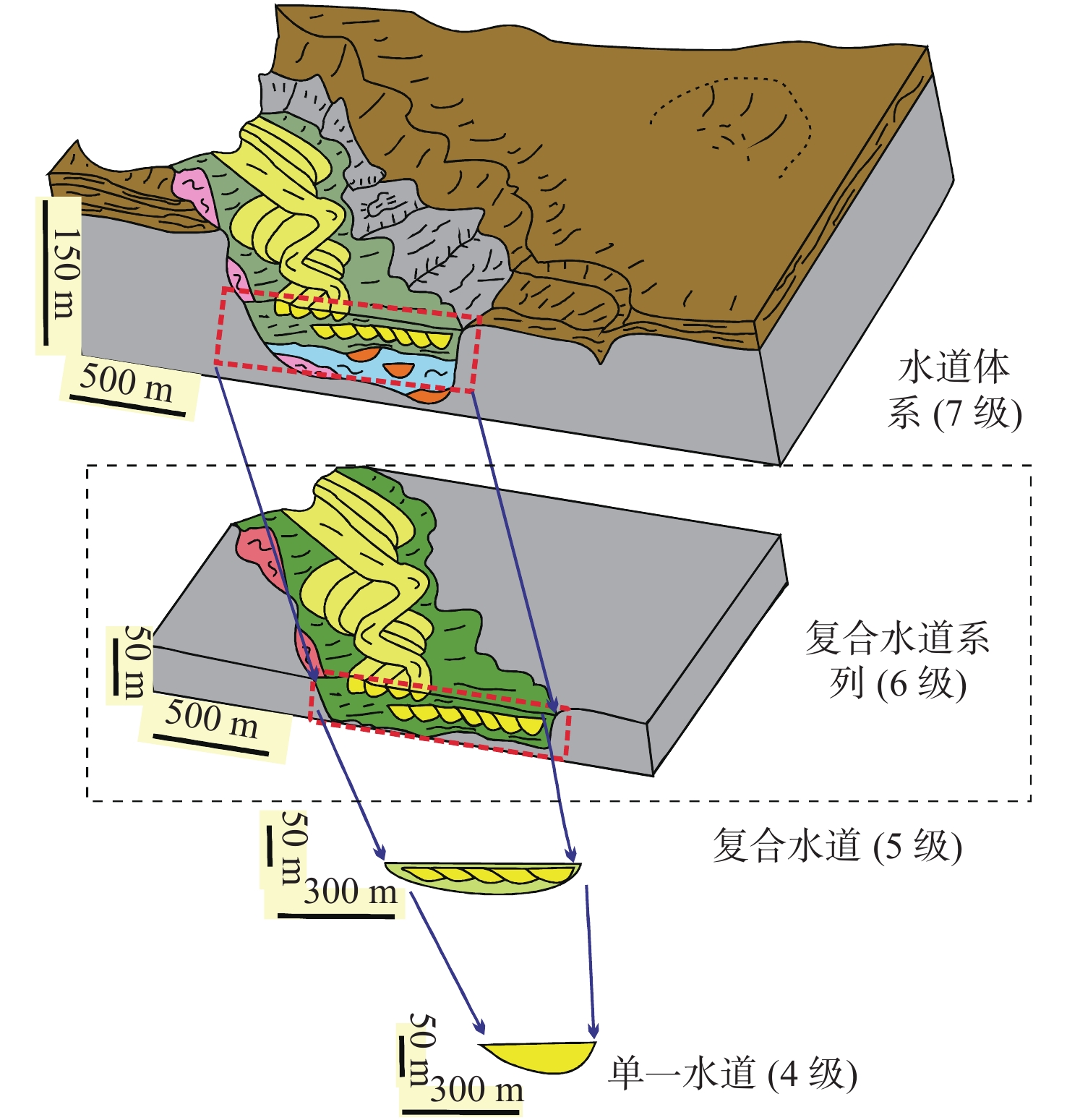
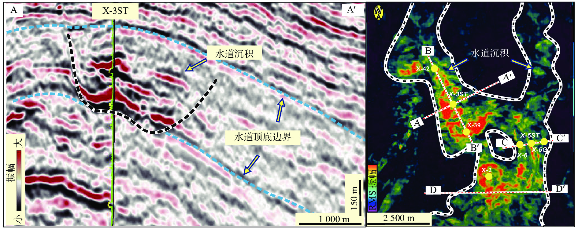
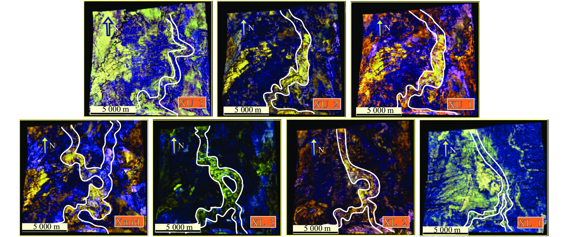
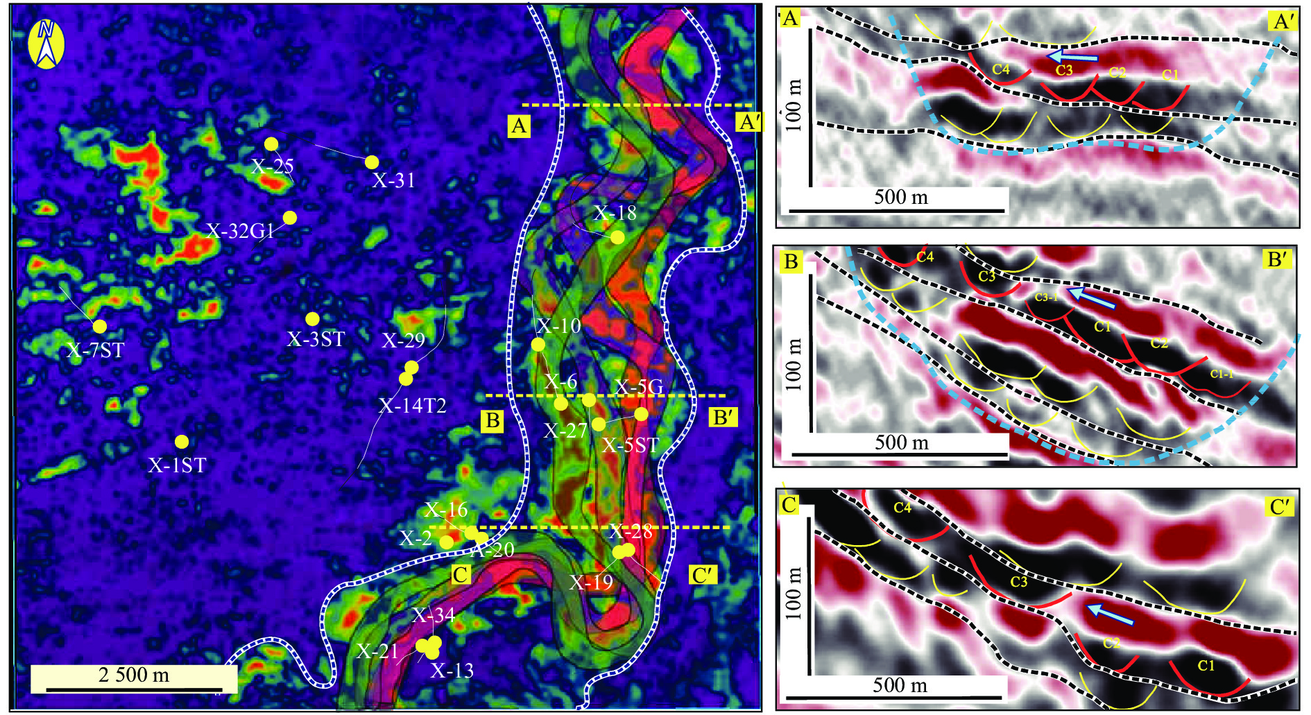
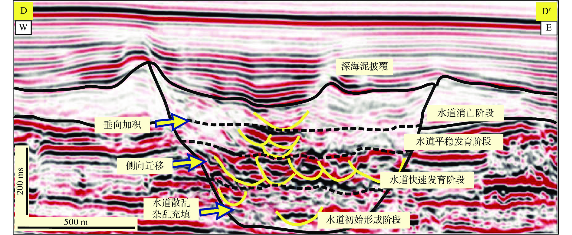
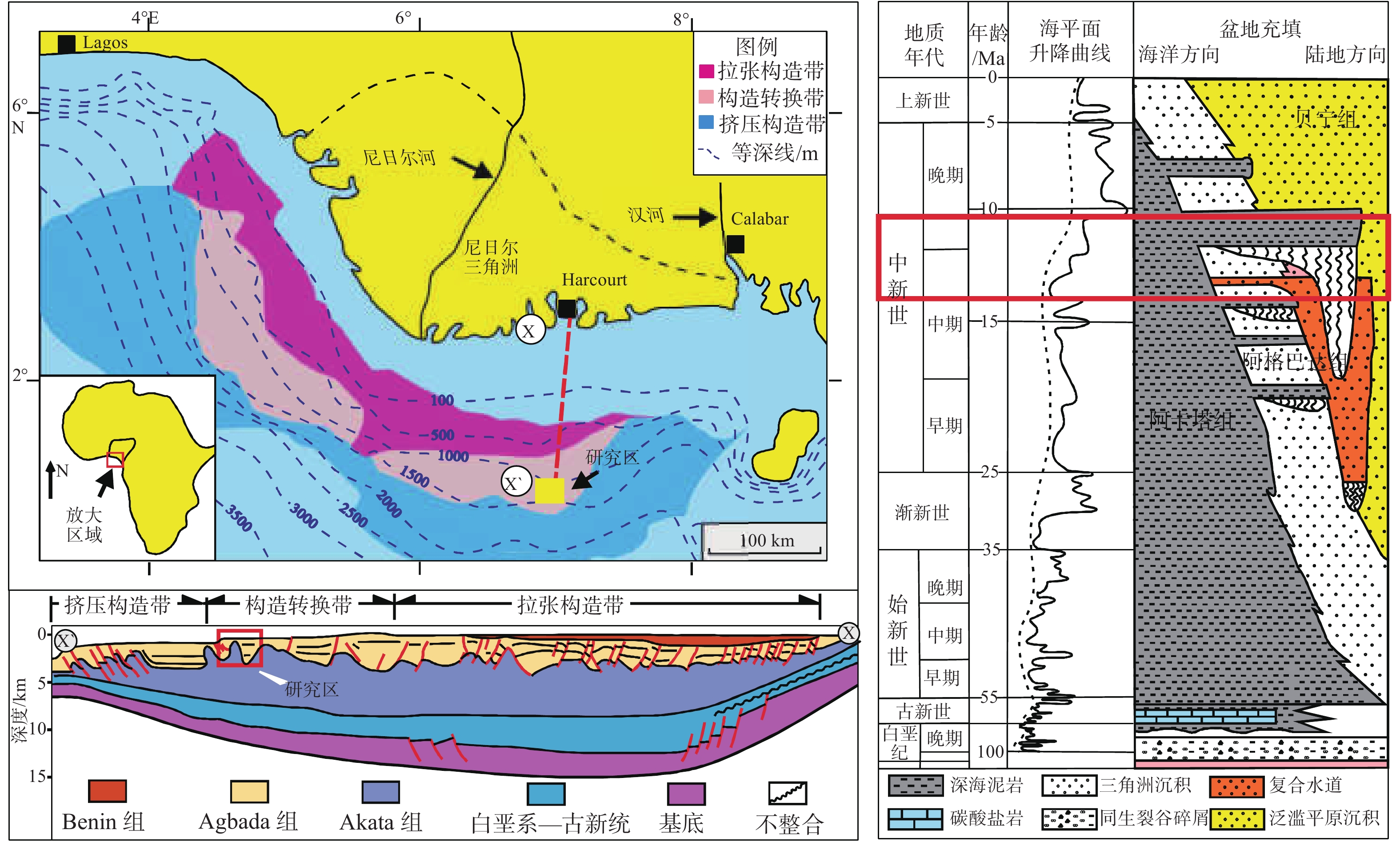
深海水道作为深水环境中重要的储层类型,具有极为丰富的深海油气资源,近年来一直是深海油田勘探和开发的重点区域,但对水道内部构型边界的识别刻画仍然是一个难点。依据三维地震数据以及测井和岩心资料,对西非X油藏水道进行了内部构型边界的精细划分,并分析了其水道演化模式。研究表明:区内水道体系边界可通过地震相特征差异进行识别,并将其分为限制性、半限制性和非限制性3种类型;复合水道边界可通过“垂向分期”和“侧向划界”原则进行确定;单一水道边界可通过水道边界振幅强弱变化进行识别,其在平面上有单侧向迁移和沿下游摆动迁移2种迁移模式,在剖面上单向侧向迁移段水道呈侧向迁移的特征,沿下游摆动段呈现出多期水道相互摆动切叠的特征;水道体系的演化可划分为初始形成、快速发育、平稳发育以及水道消亡4个阶段,对应一个完整的海平面变化旋回。
Abstract:As an important type of reservoir in deep water, the deep sea channel is extremely rich in oil and gas resources. In recent years, it has become a key area for deep sea oil exploration and development. However, it is still very difficult to identify and characterize the internal architecture boundaries of a channel. Based on 3D seismic, well logging and core data, the internal structural boundaries of the West African X reservoir channel are successfuly difined by this paper, as the channel evolutionary model is established. Research shows that the boundaries of the channel system in the study area can be defined by the differences in seismic facies characteristics. In a deep sea channel system, there are three types of boundaries: confined, semi-confined and unconfined; the boundaries of a composite channel can be defined according to the principle of “vertical staging” and “lateral zoning”, whereas the boundary of a single channel can be identified and characterized by changes in the amplitude of channel boundary. There are two migration modes: unilateral migration and downstream swing migration on plane, and unidirectional lateral migration on section. The channel characterized by lateral migration and the downstream swing section presents the characteristics of multi-phase swing and overlap of channels. The evolution of the channel system can be divided into four stages: initial formation, rapid development, stable development, and disappearance of the channel, corresponding to a complete sea level change cycle.
-
Key words:
- deep sea channel /
- channel architecture /
- boundary recognition /
- evolution pattern /
- controlling factors
-

-
[1] 赵晓明,吴胜和,刘丽. 尼日尔三角洲盆地Akpo油田新近系深水浊积水道储层构型表征[J]. 石油学报,2012,33(6):1049-1058. doi: 10.7623/syxb201206018
[2] MUTTI E,NORMARK W R. Comparing examples of modern and ancient turbidite systems:problems and concepts[J]. Marine Clastic Sedimentology Concepts and Case Studies,1987:1-38.
[3] LAMB M A,ANDERSON K S,GRAHAM S A. Stratigraphic architecture of a sand-rich,deep-sea depositional system[J]. AAPG Special Publication,2003:13.
[4] 赵晓明, 吴胜和, 岳大力, 等. 深水海底扇储层构型浅析: 以西非某油田为例[C]//第五届油气成藏机理与油气资源评价国际学术研讨会论文集. 北京: 石油工业出版社, 2010.
[5] 赵晓明,葛家旺,谭程鹏,等. 深海水道储层构型及其对同沉积构造响应机理的研究现状与展望[J]. 中国海上油气,2019,31(5):76-87.
[6] DAMUTH J E. Neogene gravity tectonics and depositional processes on the deep Niger Delta continental margin[J]. Marine and Petroleum Geology,1994,11:320-346. doi: 10.1016/0264-8172(94)90053-1
[7] DOUST H, OMATSOLA E. Niger delta[C]//Edwards J O, Santogross P A. Divergent passive margin basins Tulsa. AAPG Memoir, 1990, 48: 201-238.
[8] GORDON J,KNOX E M O. Development of the Cenozoic Niger Delta in terms of the escalator regression model and impact on hydrocarbon distribution[J]. Geology and Geotechnology,1989,17:133-138.
[9] 谢清惠,邓宏文,郭佳. 西非下刚果盆地深水曲流水道的地震响应特征与演化模式分析[J]. 石油物探,2013,6:655-661.
[10] SHORT K C,STAUBLE A J. Outline of Geology of Niger Delta[J]. AAPG Bulletin,1967,51(5):761-799.
[11] 吕明,王颖,陈莹. 尼日利亚深水区海底扇沉积模式成因探讨及勘探意义[J]. 中国海上油气,2008,20(4):275-282. doi: 10.3969/j.issn.1673-1506.2008.04.016
[12] 林煜,吴胜和,王星,等. 深水浊积水道体系构型模式研究:以西非尼日尔三角洲盆地某深水研究区为例[J]. 地质论评,2013,59(3):510-520. doi: 10.3969/j.issn.0371-5736.2013.03.011
[13] 陈筱,卜范青,王昊,等. 西非深水浊积复合水道储层连通模式表征[J]. 西南石油大学学报(自然科学版),2018,40(6):39-50.
[14] 卜范青,张旭. 深水重力流复合下切水道体系精细地质表征与建模:以西非尼日尔三角洲盆地OML130区块为例[J]. 海相油气地质,2018,23(2):90-96. doi: 10.3969/j.issn.1672-9854.2018.02.012
[15] 吴元燕, 吴胜和, 蔡正旗. 油矿地质学(第三版)[M]. 北京: 石油工业出版社, 2005.
[16] 赵晓明. 西非深水海底扇储层表征与建模[D]. 北京: 中国石油大学, 2011.
[17] PEAKALL J,MCCAFFREY W D,KNELLER B C. A process model for the evolution,morphology and architecture of meandering submarine channels[J]. Journal of Sedimentary Research,2000,70:434-448. doi: 10.1306/2DC4091C-0E47-11D7-8643000102C1865D
[18] RICHARD L,RICHARD R J. Characterization of fluvial architectural elements using a three-dimensional outcrop data set:escanilla braided system,South-Central Pyrenees,Spain[J]. Geosphere,2007,3:422-434. doi: 10.1130/GES00087.1
[19] DEPTUCK M E,SYLVESTER Z,PIRMEZ C,et al. Migration–aggradation history and 3-D seismic geomorphology of submarine channels in the Pleistocene Beninmajor Canyon,western Niger Delta slope[J]. Marine and Petroleum Geology,2007,24:406-433. doi: 10.1016/j.marpetgeo.2007.01.005
[20] ABREU V,SULLIVAN M , PIRMEZ C,et al. Lateral accretion packages (LAPs):an important reservoir element in deep water sinuous channels[J]. Marine and Petroleum Geology,2003,20:631-648. doi: 10.1016/j.marpetgeo.2003.08.003
[21] MAYALL M,JONES E,CASEY M,et al. Turbidite channel reservoirs:key elements in facies prediction and effective development[J]. Marine and Petroleum Geology,2006,23:821-841. doi: 10.1016/j.marpetgeo.2006.08.001
-
 下载:
下载:


图(10)
表(1)
计量
- 文章访问数: 942
- PDF下载数: 1
- 施引文献: 0