An analysis of the evolution trend and influencing factors of the groundwater flow field in the Sanjiang Plain
-
摘要:
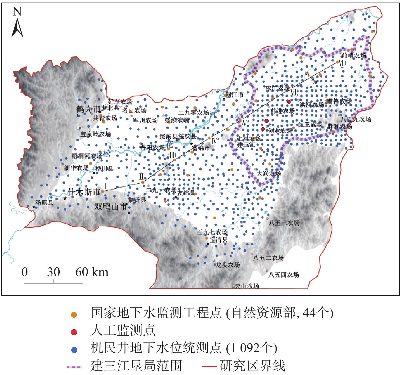
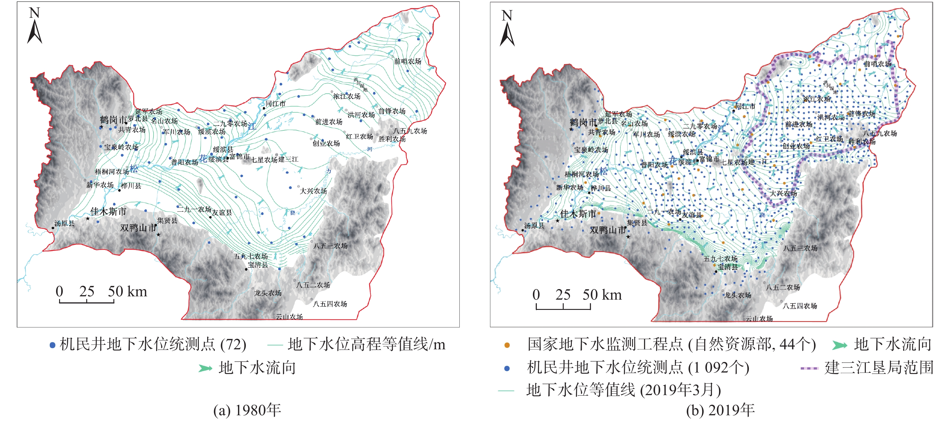
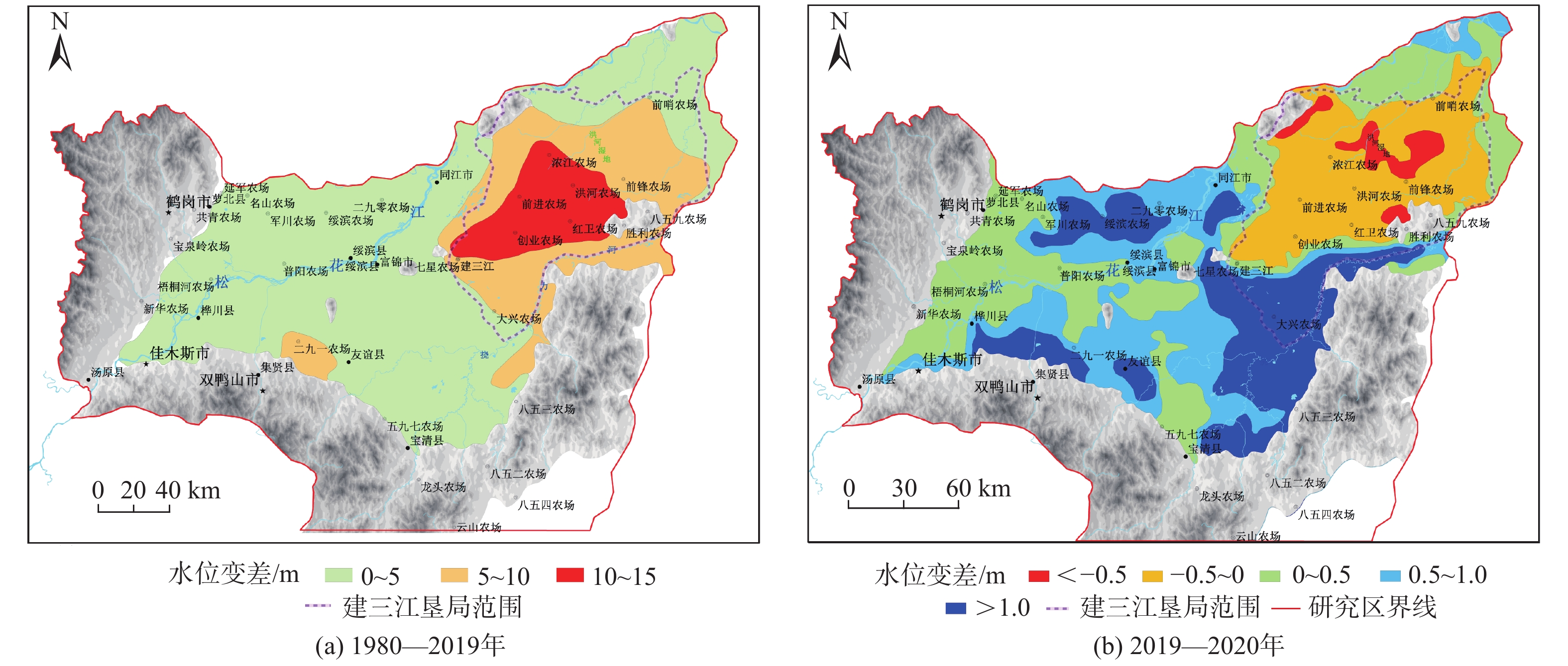
近年来,三江平原部分区域地下水位呈持续下降的态势,引起广大学者和相关部门的高度关注,为了查明三江平原地下水流场时空演化规律,揭示其主要影响因素,以三江平原1980年72组及2019、2020年同期1 092组地下水位统测数据和44组国家地下水监测数据为基础,应用ArcGIS插值分析、栅格代数运算、对比分析等方法,查明了三江平原地下水流场时空演化特征,阐明了不同影响因素对地下水流场演化的控制作用。结果表明:与1980年相比,三江平原地下水位整体呈下降趋势。西部平原区地下水位累计降幅1~5 m的区域面积2.6×10⁴ km2;东部建三江垦区累计降幅大于5 m的区域面积为1.17×10⁴ km2,其中,累计降幅大于10 m的区域面积为3 400 km2,地下水位年均降幅约0.29 m。地下水开采引起地下水流场变化,“西砂、东黏”的水文地质条件促使区域地下水降幅的时空演化差异;水田种植规模的不断扩大引起地下水超采,浅地表黏土层阻挡降水入渗补给,地下水无法实现以丰补欠自平衡,造成了建三江垦区地下水位的持续下降。本研究成果为进一步查清三江平原地下水变化规律和现状特征奠定了基础,为科学指导地下水资源合理开发利用和管理提供了技术支持。
Abstract:In recent years, groundwater levels in parts of the Sanjiang Plain has continuously decreased, which attracts great attention from scholars and related departments. In order to find out the temporal and spatial evolution of the groundwater flow field in the Sanjiang Plain and reveal its main influencing factors, in this paper the ArcGIS interpolation analysis, grid algebraic operations, comparative analysis and other methods are used to analyze the 72 groups of data in the Sanjiang Plain in 1980 and 1092 groups of groundwater level data and 44 groups of national groundwater monitoring data in the same period in 2019 and 2020. The spatio-temporal evolution characteristics of the groundwater flow field in the Sanjiang Plain are ascertained, and the control effects of different influencing factors on the smooth evolution of groundwater are clarified. The results show that, compared with 1980, the groundwater levels of the Sanjiang Plain showed an overall decreasing trend. The groundwater levels of the western plain area cumulatively decreased by 1 to 5 m, with an area of 2.6×10⁴ km2, and most areas of the eastern Jiansanjiang reclamation area fell greater than 5 m with an area of 1.17×10⁴ km2. Among them, the area where the cumulative drop of groundwater levels is greater than 10 m is as high as 3 400 km2, and the average annual drop of groundwater levels is about 0.29 m. Groundwater exploitation causes the changes in the groundwater flow field, and the hydrogeological conditions of "West Sand and East Stick" promote the temporal and spatial evolution of the regional groundwater level decline. The continuous expansion of the scale of paddy fields has caused over-exploitation of groundwater. The shallow surficial clay layer blocks replenishment from rainfall infiltration, and the groundwater cannot achieve self-balance with abundance to compensate for the shortage, resulting in the continuous decline in groundwater levels in the Jiansanjiang Reclamation Area. The results of this research lay a foundation for further investigation of the groundwater change laws and current characteristics of the Sanjiang Plain, and also provide technical support for scientifically guiding the rational development, utilization and management of groundwater resources.
-
Key words:
- Sanjiang Plain /
- groundwater flow field /
- Jiansanjiang /
- groundwater level drop /
- clay layer
-

-
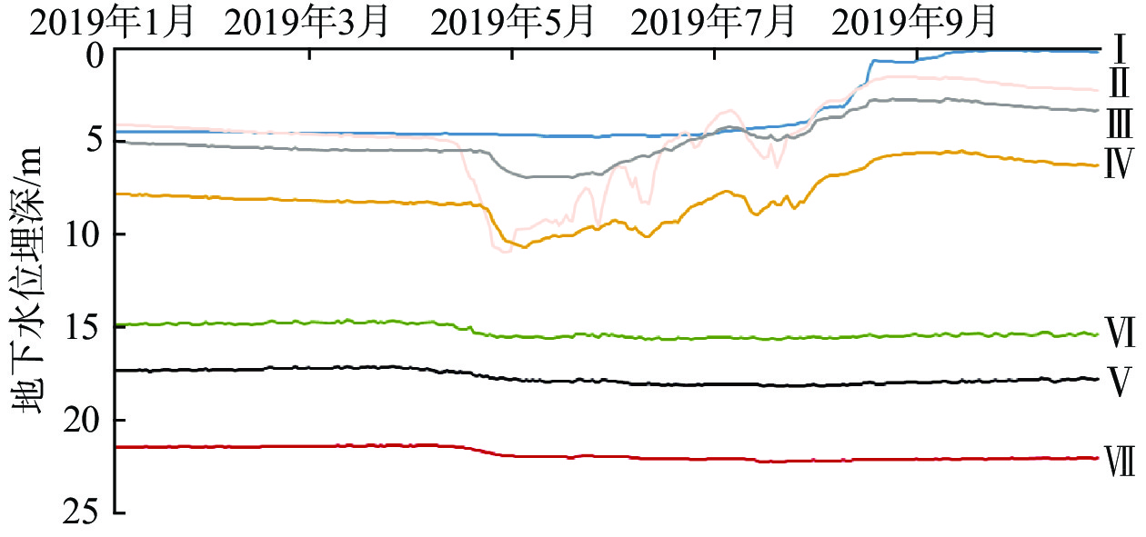
表 1 6—8月地下水埋深增大幅度
Table 1. Depth of groundwater increased significantly from June to August
空间位置 编号 地下水埋深减小幅度/m 平均减小幅度/m 西部 Ⅰ 4.077 4.002 Ⅱ 4.847 Ⅲ 3.444 Ⅳ 3.641 东部 Ⅴ −0.061 −0.055 Ⅵ 0.034 Ⅶ −0.138 -
[1] 付强, 佟兆生, 魏庆利. 建三江分局地下水资源计算与评价[J]. 农机化研究,2002,24(1):47 − 49. [FU Qiang, TONG Zhaosheng, WEI Qingli. Calculating and evaluating the groundwater resource of Jian San Jiang area[J]. Journal of Agricultural Mechanization Research,2002,24(1):47 − 49. (in Chinese with English abstract) doi: 10.3969/j.issn.1003-188X.2002.01.016
[2] 闫丹丹. 三江平原水资源时空变异特征分析[D]. 哈尔滨: 东北农业大学, 2015.
YAN Dandan. The spatiotemporal variability analysis of water resources in Sanjiang plain[D]. Harbin: Northeast Agricultural University, 2015. (in Chinese with English abstract)
[3] 唐婷. 东北地下水超采严重专家呼吁勿蹈华北覆辙[N]. 科技日报, 2018-3-22(8).
TANG Ting. The overexploitation of groundwater in Northeast China is serious, experts urge not to follow the mistakes of North China[N]. Science and Technology Daily, 2018-3-22(8). (in Chinese)
[4] 刘东. 三江平原农业水文系统复杂性测度方法与应用[M]. 北京: 中国水利水电出版社, 2011: 18-21.
LIU Dong. Computing methods and applications for complexity of agrohydrological system[M]. Beijing: China Water & Power Press, 2011: 18-21. (in Chinese)
[5] WANG X H, ZHANG G X, XU Y. Impacts of the 2013 extreme flood in northeast China on regional groundwater depth and quality[J]. Water,2015,7(12):4575 − 4592. doi: 10.3390/w7084575
[6] WANG X H, ZHANG G X, XU Y J, et al. Identifying the regional-scale groundwater-surface water interaction on the Sanjiang Plain, Northeast China[J]. Environmental Science and Pollution Research,2015,22(21):16951 − 16961. doi: 10.1007/s11356-015-4914-8
[7] 付强, 李国良. 三江平原地下水埋深时间序列的混沌研究[J]. 水土保持研究,2008,15(3):31 − 34. [FU Qiang, LI Guoliang. Chaos studies on series of groundwater depth in Sanjiang Plain[J]. Research of Soil and Water Conservation,2008,15(3):31 − 34. (in Chinese with English abstract)
[8] 赵永清, 姚景辉, 李丽娟, 等. 三江平原地下水位下降分析[J]. 黑龙江水专学报,2003,30(3):10 − 13. [ZHAO Yongqing, YAO Jinghui, LI Lijuan, et al. Analysis on underground water level descend in Sanjiang Plain[J]. Journal of Heilongjiang Hydraulic Engineering College,2003,30(3):10 − 13. (in Chinese with English abstract) doi: 10.3969/j.issn.2095-008X.2003.03.004
[9] 徐梦瑶, 梁秀娟, 王益良, 等. 三江平原地下水循环演化特征[J]. 人民黄河,2012,34(2):63 − 65. [XU Mengyao, LIANG Xiujuan, WANG Yiliang, et al. Evolution characteristics of groundwater circulation in Sanjiang Plain[J]. Yellow River,2012,34(2):63 − 65. (in Chinese with English abstract) doi: 10.3969/j.issn.1000-1379.2012.02.023
[10] 梁勇. 黑龙江省三江平原地下水动态变化原因分析[J]. 水利科技与经济,2015,21(4):97 − 98. [LIANG Yong. Analysis on the causes of groundwater dynamic changes in Sanjiang Plain in Heilongjiang Province[J]. Water Conservancy Science and Technology and Economy,2015,21(4):97 − 98. (in Chinese with English abstract) doi: 10.3969/j.issn.1006-7175.2015.04.036
[11] 杨湘奎, 孔庆轩, 李晓抗. 三江平原地下水资源合理开发利用模式探讨[J]. 水文地质工程地质,2006,33(3):49 − 52. [YANG Xiangkui, KONG Qingxuan, LI Xiaokang. Discussion of reasonable exploration and use pattern of groundwater resources in the Sanjiang Plain[J]. Hydrogeology & Engineering Geology,2006,33(3):49 − 52. (in Chinese with English abstract) doi: 10.3969/j.issn.1000-3665.2006.03.012
[12] 苏安玉, 濮励杰, 付强. 基于Kriging模型的三江平原地下水资源评价[J]. 经济地理,2007,27(6):1018 − 1020. [SU Anyu, PU Lijie, FU Qiang. Evaluation of groundwater resources based on kriging model in the Sanjiang plain[J]. Economic Geography,2007,27(6):1018 − 1020. (in Chinese with English abstract) doi: 10.3969/j.issn.1000-8462.2007.06.034
[13] 付强, 门宝辉, 王志良, 等. 非平稳时序模型在三江平原井灌水稻区地下水动态变化中的应用[J]. 系统工程理论与实践,2003,23(1):132 − 138. [FU Qiang, MEN Baohui, WANG Zhiliang, et al. Applying non-stable time series model to forecasting the groundwater dynamic varies in area of well irrigation rice in Sanjiang Plain[J]. System Engineering Theory & Practice,2003,23(1):132 − 138. (in Chinese with English abstract) doi: 10.3321/j.issn:1000-6788.2003.01.024
[14] 刘东, 马永胜, 付强. 三江平原井灌水稻区地下水动态变化规律研究[J]. 灌溉排水学报,2006,25(5):42 − 46. [LIU Dong, MA Yongsheng, FU Qiang. Study on dynamic variation regularities of groundwater in area of well irrigation paddy in Sanjiang plain[J]. Journal of Irrigation and Drainage,2006,25(5):42 − 46. (in Chinese with English abstract)
[15] 杨湘奎, 杨文, 张烽龙, 等. 三江平原地下水资源潜力与生态环境地质调查评价[M]. 北京: 地质出版社, 2008.
YANG Xiangkui, YANG Wen, ZHANG Fenglong, et al. Investigation and evaluation of the potential of groundwater resources and ecological environment in Sanjiang Plain[M]. Beijing: Geological Publishing House, 2008. (in Chinese)
[16] 尹喜霖, 柏钰春, 王勇, 等. 三江平原地下水资源潜力评价[J]. 水文地质工程地质,2004,31(6):5 − 10. [YIN Xilin, BAI Yuchun, WANG Yong, et al. Potential evaluation of groundwater resources of Sanjiang Plain in Heilongjiang Province[J]. Hydrogeology & Engineering Geology,2004,31(6):5 − 10. (in Chinese with English abstract) doi: 10.3969/j.issn.1000-3665.2004.06.002
[17] 刘玲玲, 吴剑锋, 吴吉春. 不同地质统计方法在确定渗透系数场中的对比研究[J]. 水文地质工程地质,2009,36(5):66 − 71. [LIU Lingling, WU Jianfeng, WU Jichun. A comparative study of four geostatistical methods for identifying the hydraulic conductivity fields based on test data[J]. Hydrogeology & Engineering Geology,2009,36(5):66 − 71. (in Chinese with English abstract) doi: 10.3969/j.issn.1000-3665.2009.05.015
[18] 雷能忠, 王心源, 蒋锦刚, 等. 不同地形与取样数的Kriging插值精度对比研究—以舒城县土壤全氮空间分异为例[J]. 水文地质工程地质,2008,35(5):86 − 91. [LEI Nengzhong, WANG Xinyuan, JIANG Jingang, et al. Comparison of Kriging interpolation precisions in different topographical units and number of samples: A case study of spatial distribution of soil total nitrogen in the Shucheng County[J]. Hydrogeology & Engineering Geology,2008,35(5):86 − 91. (in Chinese with English abstract) doi: 10.3969/j.issn.1000-3665.2008.05.020
[19] 张涛, 吴剑锋, 林锦, 等. 变异函数模型对渗透系数克里格插值的影响研究[J]. 水文地质工程地质,2016,43(4):1 − 7. [ZHANG Tao, WU Jianfeng, LIN Jin, et al. A comparative study of the ordinary kriging applied to hydraulic conductivity interpolation based on different variogram models[J]. Hydrogeology & Engineering Geology,2016,43(4):1 − 7. (in Chinese with English abstract)
[20] 李昊旭, 邵景力, 崔亚莉, 等. 不同作物覆盖对农业区地下水入渗补给的影响分析[J]. 水文地质工程地质,2019,46(2):57 − 65. [LI Haoxu, SHAO Jingli, CUI Yali, et al. Effects of different crop covers on vertical groundwater recharge[J]. Hydrogeology & Engineering Geology,2019,46(2):57 − 65. (in Chinese with English abstract)
[21] DE VRIES J J, SIMMERS I. Groundwater recharge: an overview of processes and challenges[J]. Hydrogeology Journal,2002,10(1):5 − 17. doi: 10.1007/s10040-001-0171-7
[22] 章光新, 王喜华, 齐鹏, 等. 三江平原水资源演变与适应性管理[M]. 北京: 中国水利水电出版社, 2018.
ZHANG Guangxin, WANG Xihua, QI Peng, et al. The evolution and adaptive management of water resources in the Sanjiang Plain[M]. Beijing: China Water Power Press, 2018. (in Chinese)
[23] 刘伟坡, 沙娜, 程旭学. 三江平原建三江地下水动态变化特征[J]. 灌溉排水学报,2020,39(5):96 − 101. [LIU Weipo, SHA Na, CHENG Xuxue. Groundwater dynamics in catchment of Jiansanjiang in Sanjiang Plain[J]. Journal of Irrigation and Drainage,2020,39(5):96 − 101. (in Chinese with English abstract)
[24] 危润初, 肖长来, 方樟. 黑龙江建三江地区地下水动态趋势突变点分析[J]. 吉林大学学报(地球科学版),2016,46(1):202 − 210. [WEI Ruichu, XIAO Chonglai, FANG Zhang. Trends mutation nodes of groundwater dynamic in Jiansanjiang area of Heilongjiang Province[J]. Journal of Jilin University (Earth Science Edition),2016,46(1):202 − 210. (in Chinese with English abstract)
[25] 翟志和, 王备麟. 黑龙江垦区建三江分局地下水资源开发利用规划报告[M]. 哈尔滨: 黑龙江农垦勘测设计研究院, 2000.
ZHAI Zhihe, WANG Beilin. Groundwater resources development and utilization planning report of Jiansanjiang Branch of Heilongjiang reclamation area[M]. Harbin: Heilongjiang Agricultural Reclamation Survey, Design and Research Institute, 2000. (in Chinese)
-


 下载:
下载:


