

Identification of dangerous rock structural planes and fracture network model in Danxia landform based on UAV aerial survey:A case study at simianshan scenic area of Chongqing
-
摘要:
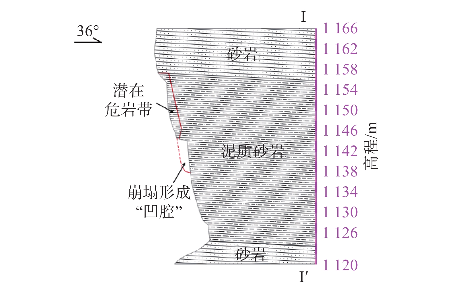
丹霞地貌地区是我国地质灾害高发区,裸露的近水平红色砂岩、砾岩陡崖是其最主要的地质特征。在地质构造与包括化学溶蚀、物理风化、重力和生物等内外动力作用下,陡崖岩体节理裂隙十分发育,危岩崩滑灾害表现出变形模式复杂、破坏力强的特点,并且由于坡体结构复杂,工程勘察难度大。为此,以四面山景区滴水岩变形危岩为例,介绍了一种基于无人机勘查技术的高陡破碎岩坡表生节理面的野外快速识别方法及高精度图像建模方法,在准确把握危岩体控制结构面的空间展布特征的基础上,建立了符合丹霞地貌高位破碎危岩的三维随机裂隙网络模型。以期为地区危岩稳定性评价与防治工作提供理论指导。
Abstract:Danxia landform is an area with high incidence of geological disasters in China. The exposed near-horizontal red sandstone and conglomerate steep cliffs are the most important identification elements. Under the internal and external dynamic action of geological structure, including chemical dissolution, physical weathering, gravity and biology, the rock mass of steep cliff is often extremely broken, and the disaster of dangerous rock collapse and slide is particularly prominent, the deformation mode is complex, the destructive power is strong, and because of the complex slope structure, the engineering investigation is difficult. So, with a deformation dangerous rock mountain scenic area as an example, this paper proposes a high-location and steep broken should based on the technology of unmanned aerial vehicle to the exploration of supergene field quickly identify methods for joint, and the accurate grasp the dangerous rock mass on the surface of the control structure on the basis of the spatial distribution characteristics of breakage of dangerous rock is established in Danxia landform high three-dimensional random fracture network model.It is expected to provide theoretical guidance for the stability evaluation and prevention of dangerous rock in the region.
-

-
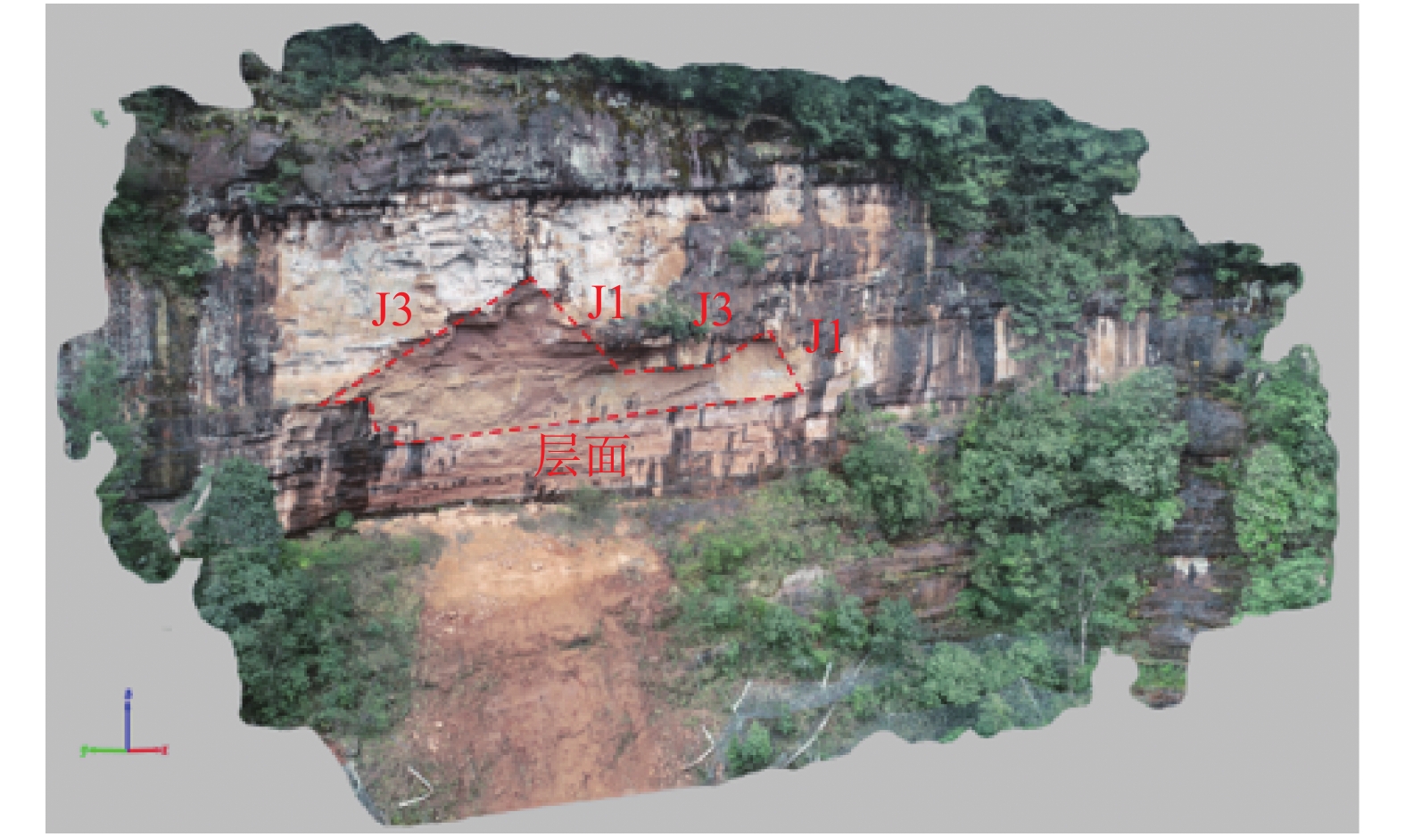
表 1 结构面优势分组结果
Table 1. Structural plane for the group advantage
分组 类型 倾向/(°) 倾角/(°) 样本① 样本② 样本③ 平均值 样本① 样本② 样本③ 平均值 Ⅰ 岩层层面 328.75 328.53 282.56 313.28 9.75 10.69 9.94 10.13 Ⅱ 节理J1 210.48 215.66 203.91 210.02 84.71 86.01 84.56 85.10 Ⅲ 节理J2 127.19 122.47 125.24 124.97 89.69 87.63 81.54 86.29 Ⅳ 节理J3 279.62 305.55 287.48 290.88 33.53 20.36 39.20 31.03  下载: 导出CSV
-
[1] 王圻仲. 川西南地区莜坝-中都丹霞地貌成景机制及脆弱性研究[D]. 成都: 成都理工大学, 2020.
WANG Qizhong. Study on formation mechanism and vulnerability of Qiaoba-Zhongdu Danxia landform in southwest Sichuan[D]. Chengdu: Chengdu University of Technology, 2020. (in Chinese with English abstract)
[2] 李滨, 殷跃平, 高杨, 等. 西南岩溶山区大型崩滑灾害研究的关键问题[J]. 水文地质工程地质,2020,47(4):5 − 13. [LI Bin, YIN Yueping, GAO Yang, et al. Critical issues in rock avalanches in the karst mountain areas of southwest China[J]. Hydrogeology & Engineering Geology,2020,47(4):5 − 13. (in Chinese with English abstract)
[3] 郑海中, 彭振斌. 地质工程的研究现状及其风险表现[J]. 中国地质灾害与防治学报,2008,19(1):105 − 108. [ZHENG Haizhong, PENG Zhenbin. Review of research and risk of Geological Engineering[J]. The Chinese Journal of Geological Hazard and Control,2008,19(1):105 − 108. (in Chinese with English abstract) doi: 10.3969/j.issn.1003-8035.2008.01.023
[4] HUANG H F, LONG J J, LIN H Y, et al. Unmanned aerial vehicle based remote sensing method for monitoring a steep mountainous slope in the Three Gorges Reservoir, China[J]. Earth Science Informatics,2017,10(3):287 − 301. doi: 10.1007/s12145-017-0291-9
[5] 王凤艳, 赵明宇, 王明常, 等. 无人机摄影测量在矿山地质环境调查中的应用[J]. 吉林大学学报(地球科学版),2020,50(3):866 − 874. [WANG Fengyan, ZHAO Mingyu, WANG Mingchang, et al. Application of UAV photogrammetry in mine geological environment survey[J]. Journal of Jilin University (Earth Science Edition),2020,50(3):866 − 874. (in Chinese with English abstract)
[6] 张剑清, 潘励, 王树根. 测绘科学[M]. 武汉: 武汉大学出版社, 2003.
ZHANG Jianqing, PAN Li, WANG Shugen. Science of surveying and mapping[M]. Wuhan: Wuhan University Press, 2003. (in Chinese)
[7] 宋晓晨, 徐卫亚. 裂隙岩体渗流模拟的三维离散裂隙网络数值模型(Ⅰ): 裂隙网络的随机生成[J]. 岩石力学与工程学报,2004,23(12):2015 − 2020. [SONG Xiaochen, XU Weiya. Numerical model of three-dimensional discrete fracture network for seepage in fractured rocks (Ⅰ): generation of fracture network[J]. Chinese Journal of Rock Mechanics and Engineering,2004,23(12):2015 − 2020. (in Chinese with English abstract) doi: 10.3321/j.issn:1000-6915.2004.12.012
[8] 王凤艳, 韩东亮, 张元元, 等. 基于轴对准法的坐标系生成与转换[J]. 测绘通报,2013(7):43 − 45. [WANG Fengyan, HAN Dongliang, ZHANG Yuanyuan, et al. Generation and transformation of coordinate system based on axis alignment[J]. Bulletin of Surveying and Mapping,2013(7):43 − 45. (in Chinese with English abstract)
[9] BENKO B, STEAD D. The Frank slide: a reexamination of the failure mechanism[J]. Canadian Geotechnical Journal,1998,35(2):299 − 311. doi: 10.1139/t98-005
[10] 谷德振. 岩土力学[M]. 北京: 科学出版社, 1979.
GU Dezhen. Rock and soil mechanics[M]. Beijing: Science press, 1979. (in Chinese)
[11] 张文, 韩博, 孙昊林, 等. 高陡岩质斜坡的结构面非接触式采集技术与三维裂隙网络模拟研究[J]. 工程地质学报,2020,28(2):221 − 231. [ZHANG Wen, HAN Bo, SUN Haolin, et al. Non-contact collection and 3D fracture network modelling for high-steep rock slopes[J]. Journal of Engineering Geology,2020,28(2):221 − 231. (in Chinese with English abstract)
[12] 邱振忠. 层流-紊流共存流场中岩溶裂隙网络演化数值模拟方法[D]. 北京: 中国地质大学(北京), 2019.
QIU Zhenzhong. A numerical simulation method of Karst fracture network evolution in laminar-turbulent coexistence flow field[D]. Beijing: China University of Geosciences, 2019. (in Chinese with English abstract)
[13] 毕瑞, 甘淑, 李绕波, 等. 面向东川复杂山地泥石流沟谷三维地形建模及特征分析的无人机遥感探测应用研究[J]. 中国地质灾害与防治学报,2021,32(3):91 − 100. [BI Rui, GAN Shu, LI Raobo, et al. Application research of unmanned aerial vehicle remote sensing detection for 3D terrain modeling and feature analysis of debris flow gullies in complex mountainous area of Dongchuan[J]. The Chinese Journal of Geological Hazard and Control,2021,32(3):91 − 100. (in Chinese with English abstract)
[14] 贾虎军, 王立娟, 范冬丽. 无人机载LiDAR和倾斜摄影技术在地质灾害隐患早期识别中的应用[J]. 中国地质灾害与防治学报,2021,32(2):60 − 65. [JIA Hujun, WANG Lijuan, FAN Dongli. The application of UAV LiDAR and tilt photography in the early identification of geo-hazards[J]. The Chinese Journal of Geological Hazard and Control,2021,32(2):60 − 65. (in Chinese with English abstract)
[15] 吴瑞安, 马海善, 张俊才, 等. 金沙江上游沃达滑坡发育特征与堵江危险性分析[J]. 水文地质工程地质,2021,48(5):120 − 128. [WU Rui'an, MA Haishan, ZHANG Juncai, et al. Developmental characteristics and damming river risk of the Woda landslide in the upper reaches of the Jinshajiang River[J]. Hydrogeology & Engineering Geology,2021,48(5):120 − 128. (in Chinese with English abstract)
-
图(8)
表(1)
计量
- 文章访问数: 1113
- PDF下载数: 26
- 施引文献: 0