

Three-dimensional movement inversion of Shisha Pangma glacier using Sentinel-1 and Landsat8 images
-
摘要:
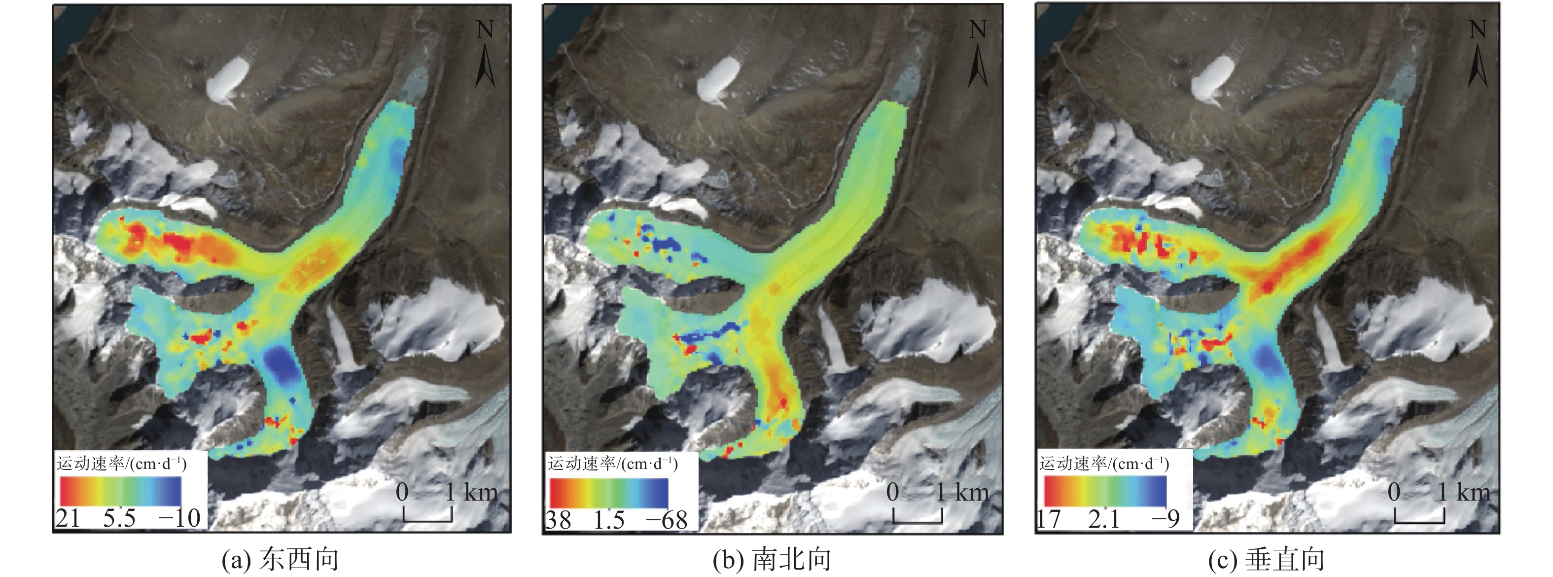
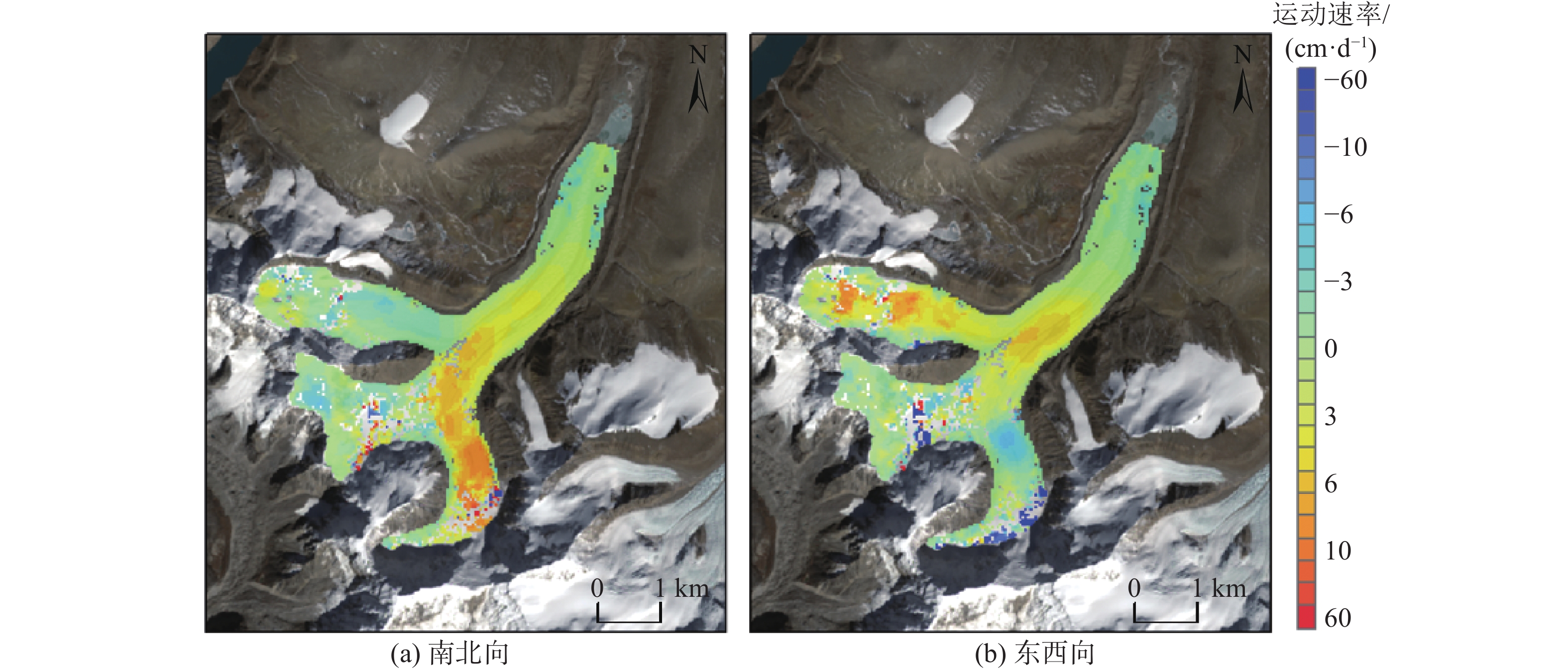
SAR偏移量技术和光学偏移量技术是冰川运动监测重要的技术手段,但目前对于融合不同平台的影像进行三维形变的研究较少。文章选取2019年11月至2021年1月西藏聂拉木县希夏邦马峰地区的大型冰川作为研究对象,基于方差分量估计融合该研究区的Sentinel-1与Landsat8两种数据进行冰川的三维位移解算,选取了同一时期的光学影像对偏移量估计结果进行对比分析,同时选取稳定区域进行精度评估,分析该方法在冰川运动监测中的适用性和精确性。结果表明,该冰川在2019年11月至2021年1月,联合解算的东西向最大流速为21 cm/d,南北向最大流速为68 cm/d,垂直向最大流速为17 cm/d。对比单一影像获取的冰川位移结果,多影像联合解算方法,能够弥补SAR数据的失相干和光学数据的低质量像元值的不足,获得更加完整和详细的冰川信息,监测结果精度更高。可为利用不同平台的数据联合监测山地冰川的多维度和高精度变化提供参考和技术支持。
-
关键词:
- Sentinel-1 /
- Landsat8 /
- 偏移量跟踪技术 /
- 联合解算 /
- 冰川三维监测
Abstract:SAR offset and optical offset are important techniques for glacier movement monitoring, but there are few researches on 3D deformation by integrating images from different platforms. In this paper, large glaciers in The Shisha Pangma area of Nyalam County, Tibet from November 2019 to January 2021 were selected as the research area. Based on variance component estimation, Sentinel-1 and Landsat8 data of the study area were combined for three-dimensional glacier calculation. Optical images of the same period were selected for comparative analysis of the offset estimation results. At the same time, the accuracy of the method was evaluated by selecting the stable area, and the applicability and accuracy of the method in glacier movement monitoring were analyzed. The results show that the maximum velocity of the glacier is 21 cm/day in the east-west direction, 68 cm/day in the north-south direction, and 17 cm/day in the vertical direction. Compared with the glacier displacement results obtained from a single image, the multi-image joint algorithm can compensate for the incoherence of SAR data and the low quality pixel values of optical data, and obtain more complete and detailed glacier information and higher accuracy of monitoring results. This paper can provide reference and technical support for using data from different platforms to jointly monitor multi-dimensional and high-precision changes of mountain glaciers.
-

-
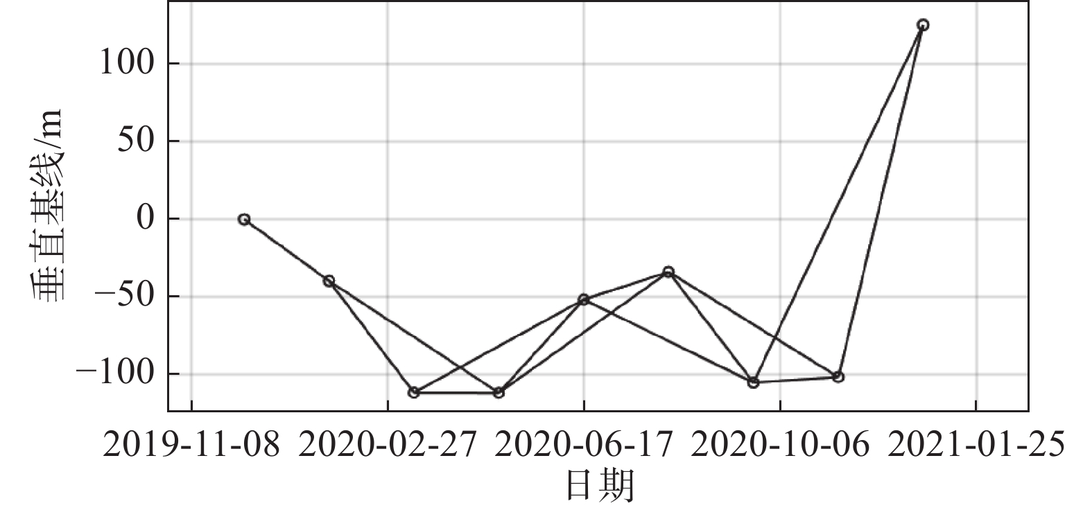
表 1 研究所采用的Sentinel-1数据参数
Table 1. The Sentinel-1 data parameters used in the study
影像编号 采集日期 空间基线/m 时间基线/d 1 2019-12-08 0.00 0 2 2020-01-25 −39.83 48 3 2020-03-13 −112.08 96 4 2020-04-30 −112.19 144 5 2020-06-17 −51.88 192 6 2020-08-04 −33.98 240 7 2020-09-21 −105.59 288 8 2020-11-08 −101.99 336 9 2020-12-26 125.79 384  下载: 导出CSV
表 2 研究所采用的Landsat8影像参数
Table 2. The Landsat8 imaging parameters used in the study
影像编号 采集日期 太阳高度角/(°) 太阳方位角/(°) 含云量/% 1 2019-11-19 38.52 157.40 1.74 2 2020-01-22 35.61 150.5 4.65 3 2020-02-07 39.10 147.2 3.28 4 2020-11-21 37.78 157.5 2.54 5 2021-01-08 33.93 153.0 4.20 6 2021-01-24 36.10 150.0 1.32
下载: 导出CSV
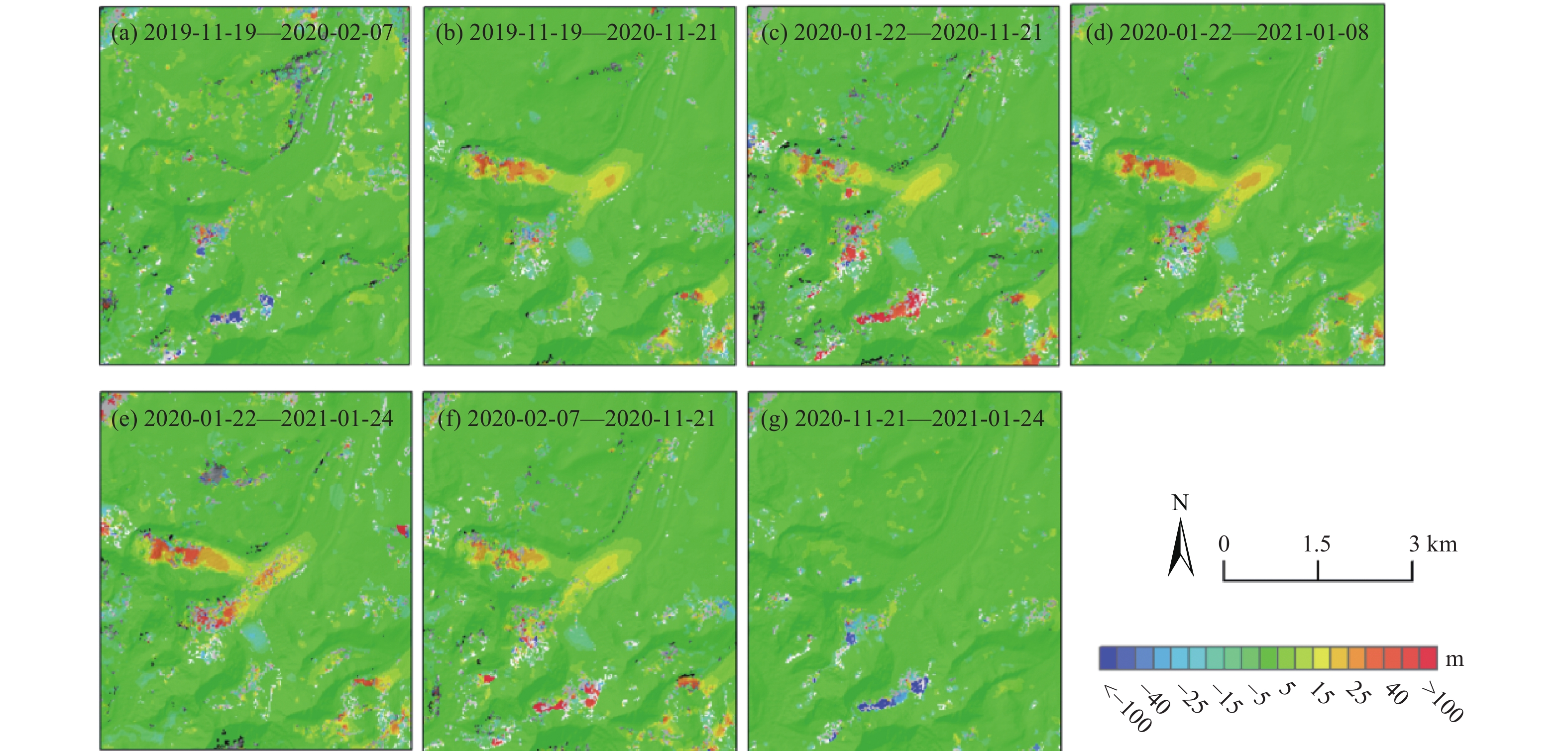
表 3 研究所采用的Landsat8影像对
Table 3. The Landsat8 image pairs used in the study
Landsat8影像对的日期 太阳高度角差值/(°) 太阳方位角差值/(°) 2019-11-19—2020-02-07 0.58 10.2 2019-11-19—2020-11-21 0.74 0.1 2020-01-22—2020-11-21 2.17 7.0 2020-01-22—2021-01-08 1.68 2.5 2020-01-22—2021-01-24 0.49 0.5 2020-02-07—2020-11-21 1.32 0.5 2020-11-21—2021-01-24 1.68 7.5
下载: 导出CSV
表 4 融合后和同期影像对稳定区域的标准差统计
Table 4. Standard deviation statistics for st able regions after fusion and concurrent images
统计值 融合后结果/(cm·d−1) Landsat8影像对结果/(cm·d−1) 南北向 东西向 南北向 东西向 Roi1 0.56 0.91 1.0 0.99 Roi2 0.48 0.60 0.77 0.84
下载: 导出CSV
-
[1] 姚晓军, 刘时银, 孙美平, 等. 20世纪以来西藏冰湖溃决灾害事件梳理[J]. 自然资源学报,2014,29(8):1377 − 1390. [YAO Xiaojun, LIU Shiyin, SUN Meiping, et al. Study on the glacial lake outburst flood events in Tibet since the 20th century[J]. Journal of Natural Resources,2014,29(8):1377 − 1390. (in Chinese with English abstract)
[2] 童龙云, 张继, 孔应德. 西藏定日朋曲流域达仓沟冰湖溃决泥石流特征[J]. 中国地质灾害与防治学报,2019,30(6):34 − 39. [TONG Longyun, ZHANG Ji, KONG Yingde. Characteristics of the dacanggou debris flow induced by breakout of glacier-lake in the Pengqu basin Diri County of Tibet[J]. The Chinese Journal of Geological Hazard and Control,2019,30(6):34 − 39. (in Chinese with English abstract)
[3] 王伟财. 藏东南伯舒拉岭地区冰湖变化及危险性与影响分析[D]. 北京: 中国科学院大学, 2013
WANG Weicai. Variation of glacial lakes and assessment of GLOF hazards in the Boshula mountain range, southeast of Tibetan Plateau[D]. Beijing: University of Chinese Academy of Sciences, 2013. (in Chinese with English abstract)
[4] 刘春玲, 童立强, 祁生文, 等. 喜马拉雅山地区冰川湖溃决灾害隐患遥感调查及影响因素分析[J]. 国土资源遥感,2016,28(3):110 − 115. [LIU Chunling, TONG Liqiang, QI Shengwen, et al. Remote sensing investigation and influence factor analysis of glacier lake outburst potential in the Himalayas[J]. Remote Sensing for Land & Resources,2016,28(3):110 − 115. (in Chinese with English abstract)
[5] 刘建康, 张佳佳, 高波, 等. 我国西藏地区冰湖溃决灾害综述[J]. 冰川冻土,2019,41(6):1335 − 1347. [LIU Jiankang, ZHANG Jiajia, GAO Bo, et al. An overview of glacial lake outburst flood in Tibet, China[J]. Journal of Glaciology and Geocryology,2019,41(6):1335 − 1347. (in Chinese with English abstract)
[6] GOLDSTEIN R M, ENGELHARDT H, KAMB B, et al. Satellite radar interferometry for monitoring ice sheet motion: Application to an Antarctic ice stream[J]. Science,1993,262(5139):1525 − 1530. doi: 10.1126/science.262.5139.1525
[7] RIGNOT E, MOUGINOT J, SCHEUCHL B. Ice flow of the Antarctic ice sheet[J]. Science,2011,333(6048):1427 − 1430. doi: 10.1126/science.1208336
[8] KUMAR V, VENKATARAMAN G, HØGDA K A, et al. Estimation and validation of glacier surface motion in the northwestern Himalayas using high-resolution SAR intensity tracking[J]. International Journal of Remote Sensing,2013,34(15):5518 − 5529. doi: 10.1080/01431161.2013.792965
[9] STROZZI T, LUCKMAN A, MURRAY T, et al. Glacier motion estimation using SAR offset-tracking procedures[J]. IEEE Transactions on Geoscience and Remote Sensing,2002,40(11):2384 − 2391. doi: 10.1109/TGRS.2002.805079
[10] SCHERLER D, LEPRINCE S, STRECKER M R. Glacier-surface velocities in alpine terrain from optical satellite imagery—Accuracy improvement and quality assessment[J]. Remote Sensing of Environment,2008,112(10):3806 − 3819. doi: 10.1016/j.rse.2008.05.018
[11] DEHECQ A, GOURMELEN N, TROUVE E. Deriving large-scale glacier velocities from a complete satellite archive: Application to the Pamir-Karakoram-Himalaya[J]. Remote Sensing of Environment,2015,162:55 − 66. doi: 10.1016/j.rse.2015.01.031
[12] BERTHIER E, VADON H, BARATOUX D, et al. Surface motion of mountain glaciers derived from satellite optical imagery[J]. Remote Sensing of Environment,2005,95(1):14 − 28. doi: 10.1016/j.rse.2004.11.005
[13] DEHECQ A, GOURMELEN N, TROUVE E. Deriving large-scale glacier velocities from a complete satellite archive: Application to the Pamir-Karakoram-Himalaya[J]. Remote Sensing of Environment,2015,162:55 − 66. doi: 10.1016/j.rse.2015.01.031
[14] HU J, LI Z W, DING X L, et al. 3D coseismic Displacement of 2010 Darfield, New Zealand earthquake estimated from multi-aperture InSAR and D-InSAR measurements[J]. Journal of Geodesy,2012,86(11):1029 − 1041. doi: 10.1007/s00190-012-0563-6
[15] GRAY L. Using multiple RADARSAT InSAR pairs to estimate a full three-dimensional solution for glacial ice movement[J]. Geophysical Research Letters,2011,38(5).
[16] MINCHEW B M, SIMONS M, RIEL B, et al. Tidally induced variations in vertical and horizontal motion on Rutford Ice Stream, West Antarctica, inferred from remotely sensed observations[J]. Journal of Geophysical Research:Earth Surface,2017,122(1):167 − 190. doi: 10.1002/2016JF003971
[17] HU J, LI Z W, DING X L, et al. Two-dimensional co-seismic surface displacements field of the Chi-Chi earthquake inferred from SAR image matching[J]. Sensors (Basel, Switzerland),2008,8(10):6484 − 6495. doi: 10.3390/s8106484
[18] LI J, LI Z W, WU L X, et al. Deriving a time series of 3D glacier motion to investigate interactions of a large mountain glacial system with its glacial lake: use of Synthetic Aperture Radar Pixel Offset-Small Baseline Subset technique[J]. Journal of Hydrology,2018,559:596 − 608. doi: 10.1016/j.jhydrol.2018.02.067
[19] 敖萌, 张路, 廖明生, 等. 基于方差分量估计的多源InSAR数据自适应融合形变测量[J]. 地球物理学报,2020,63(8):2901 − 2911. [AO Meng, ZHANG Lu, LIAO Mingsheng, et al. Deformation monitoring with adaptive integration of multi-source InSAR data based on variance component estimation[J]. Chinese Journal of Geophysics,2020,63(8):2901 − 2911. (in Chinese with English abstract)
[20] 李海, 杨成生, 惠文华, 等. 基于遥感技术的高山极高山区冰川冰湖变化动态监测: 以西藏藏南希夏邦玛峰地区为例[J]. 中国地质灾害与防治学报,2021,32(5):10 − 17. [LI Hai, YANG Chengsheng, HUI Wenhua, et al. Changes of glaciers and glacier lakes in alpine and extremely alpine regions using remote sensing technology: a case study in the Shisha Pangma area of southern Tibet[J]. The Chinese Journal of Geological Hazard and Control,2021,32(5):10 − 17. (in Chinese with English abstract)
[21] BERARDINO P, FORNARO G, LANARI R, et al. A new algorithm for surface deformation monitoring based on small baseline differential SAR interferograms[J]. IEEE Transactions on Geoscience and Remote Sensing,2002,40(11):2375 − 2383. doi: 10.1109/TGRS.2002.803792
[22] 杨丽叶, 赵超英, 杨成生. PO-SBAS技术用于错朗玛冰川三维时序运动特征分析[J]. 地球物理学进展,2020,35(6):2116 − 2123. [YANG Liye, ZHAO Chaoying, YANG Chengsheng. Three-dimensional time series movement analysis of the Cuolangma glacier with PO-SBAS technique[J]. Progress in Geophysics,2020,35(6):2116 − 2123. (in Chinese with English abstract)
[23] 贺礼家, 冯光财, 冯志雄, 等. 哨兵-2号光学影像地表形变监测: 以2016年MW7.8新西兰凯库拉地震为例[J]. 测绘学报,2019,48(3):339 − 351. [HE Lijia, FENG Guangcai, FENG Zhixiong, et al. Coseismic displacements of 2016 MW7.8 Kaikoura, New Zealand earthquake, using Sentinel-2 optical images[J]. Acta Geodaetica et Cartographica Sinica,2019,48(3):339 − 351. (in Chinese with English abstract)
[24] 柳林, 宋豪峰, 杜亚男, 等. 联合哨兵2号和Landsat 8估计白格滑坡时序偏移量[J]. 武汉大学学报·信息科学版,2021,46(10):1461 − 1470. [LIU Lin, SONG Haofeng, DU Yanan, et al. Time-series offset tracking of the Baige landslide based on Sentinel-2 and Landsat8[J]. Geomatics and Information Science of Wuhan University,2021,46(10):1461 − 1470. (in Chinese with English abstract)
[25] 胡俊. 基于现代测量平差的InSAR三维形变估计理论与方法[D]. 长沙: 中南大学, 2013
HU Jun. Theory and method of estimating three-dimensional displacement with InSAR based on the modern surveying adjustment[D]. Changsha: Central South University, 2013. (in Chinese with English abstract)
-


图(13)
表(4)
计量
- 文章访问数: 1963
- PDF下载数: 56
- 施引文献: 0