

GEOMORPHOLOGICAL EVOLUTION OF THE BARRIER-LAGOON SYSTEM NEAR THE JINGTANG PORT, HEBEI PROVINCE
-
摘要:
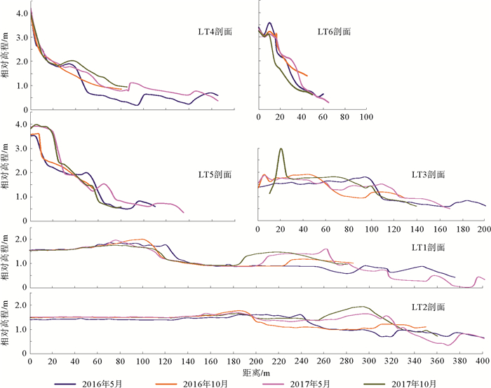
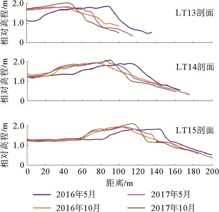
河北省的沙坝—潟湖海岸,在自然因素和人类活动的双重影响下逐渐消亡,砂质岸线不断蚀退。基于京唐港附近15条海滩剖面2016—2017年夏、冬两季共4次监测结果,开展了剖面地形和表层沉积物粒度的时空变化研究。监测结果显示,海岸整体呈现蚀退,其中永乐岛和明月岛呈侵蚀淤积交替出现;吉祥岛受人为因素影响小,侵蚀严重,残留沙坝2年累计侵蚀10~30 m,每年夏季较冬季侵蚀显著。2016年度剖面冬季较夏季沉积物变粗,由于部分剖面沙滩侵蚀严重,淤泥质基底出露,沉积物变细。
Abstract:The barrier-lagoon coast of Hebei province is gradually varnishing by both natural factors and human activities, and the sandy coastline is continuously eroding. Based on 4 times of monitoring for 15 beach profiles near the Jingtang Port in summer and winter seasons, the spatial and temporal variation in geomorphology and grain size distribution pattern of the surface sediment was studied. The results show that the coast is now under erosion as a general trend. Erosion and siltation alternate in the Yongle Island and Mingyue Island. However, the Jixiang Island is less effected by human activities, but suffers serious erosion, and the residual sand bars has been eroded by 10~30 m in 2 years. Surface sediment monitoring in 2016 indicated that the deposits become coarser in winter. Because of the severe erosion of sand beaches in some profiles, the silt basement was exposed, which resulted in the fining of sediments.
-
Key words:
- barrier-lagoon coast /
- beach erosion /
- profile feature /
- monitoring beach profile
-

-
[1] De Swart H E, Zimmerman J T F. Morphodynamics of tidal inlet systems[J]. The Annual Review of Fluid Mechanics, 2009, 41(1): 203-229. doi: 10.1146/annurev.fluid.010908.165159
[2] 高抒.潮汐汊道开发中的水环境问题[J].水资源保护, 2002(3):18-21. doi: 10.3969/j.issn.1004-6933.2002.03.006
[3] 戴志军, 施伟勇, 陈浩.沙坝—潟湖海岸研究进展与展望[J].上海国土资源, 2011, 32(3):12-17. doi: 10.3969/j.issn.2095-1329.2011.03.006
[4] Beets D J, Roep T B, Westenrhoff W E. The Holocene Bergen Inlet: closing history and related barrier progradation[M]//Coastal Studies on the Holocene of the Netherlands. Boom-Planeta, The Netherlands, 1996: 97-131.
[5] Elias E P L, Spek A J F. Long-term morphodynamic evolution of Texel inlet and its ebb-tidal delta (the Netherlands)[J]. Marine Geology, 2006, 225: 5-21. doi: 10.1016/j.margeo.2005.09.008
[6] Davis R A, Yale K E, Pekala J M, et al. Barrier island stratigraphy and Holocene history of west-central Florida[J]. Marine Geology, 2003, 200(1): 103-123. http://www.wanfangdata.com.cn/details/detail.do?_type=perio&id=4a39aed1850d5660897be19f451c5814
[7] 刘益旭, 朱利康, 王连河.滦河废弃三角洲潟湖沙坝海岸演变与海港建设[J].海洋学报, 1994, 16(5):60-67. http://www.cqvip.com/Main/Detail.aspx?id=1362650
[8] 李从先, 陈刚, 王利.滦河废弃三角洲和沙坝—潟湖沉积体系[J].沉积学报, 1983, 1(2):84-95. http://www.cnki.com.cn/Article/CJFDTotal-CJXB198302004.htm
[9] 高善明, 李元芳, 安凤桐, 等.滦河三角洲滨岸沙体的形成和海岸线变迁[J].海洋学报.1980, 36(3):308-313. http://www.cnki.com.cn/Article/CJFD1980-SEAC198004009.htm
[10] 邢容容, 刘修锦, 邱若峰, 等.唐山市砂质岸线近期冲淤演变分析[J].海洋环境科学, 2017, 2(4):102-114. http://www.cqvip.com/QK/95945X/201701/671303852.html
[11] 李少红.京唐港泥沙问题及港口发展[J].水运工程, 2002(3):1-3. http://www.wanfangdata.com.cn/details/detail.do?_type=perio&id=sygc200203001
[12] 罗肇森, 马进荣, 张晓艳.从京唐港大风期骤淤浅议粉砂质海岸建港布置和航道选线[J].中国港湾建设, 2007(1):35-41. doi: 10.3969/j.issn.1003-3688.2007.01.011
[13] 邱若峰, 杨燕熊, 张甲波, 等.打网岗岸滩动态分析与生态修复[J].海洋地质动态, 2010, 26(4):13-18. http://www.cnki.com.cn/Article/CJFDTotal-HYDT201004004.htm
[14] 陈文超, 邱若峰, 邢容容, 等.基于强浪下的祥云岛岸滩侵淤特征及防护措施[J].海洋地质前沿, 2016, 32(11):40-46. http://www.jhyqy.com.cn/cn/article/doi/10.16028/j.1009-2722.2016.11006
[15] 张忍顺, 李坤平.滦河三角洲海岸潮汐汊道—湖盆体系的演变[J].海洋工程, 1996, 14(4):45-52. http://www.cnki.com.cn/Article/CJFDTotal-HYGC604.006.htm
[16] Grasso F, Michallet H, Barthbelemy E. Experimental simulation of shoreface nourishments under storm events: A morphological, hydrodynamic, and sediment grain size analysis[J]. Coastal Engineering, 2011, 58: 184-193. doi: 10.1016/j.coastaleng.2010.09.007
[17] 刘有才, 左丽明, 李战.河北省海岸侵蚀动态及成因机制研究[J].城市地质, 2016, 11(2):43-47. doi: 10.3969/j.issn.1007-1903.2016.02.009
[18] 高伟明, 杨剑霞.渤海湾北部滨外沙坝演变的遥感分析[J].地理与地理信息科学, 2006, 22(5):41-44. doi: 10.3969/j.issn.1672-0504.2006.05.008
-
 下载:
下载:


图(6)
计量
- 文章访问数: 997
- PDF下载数: 58
- 施引文献: 0