

A study of mapping method in the marine volcanic terrain:A case study of paleovolcanic edifices of the Baiyin orefield in the eastern part of the North Qilian Mountain
-
摘要:
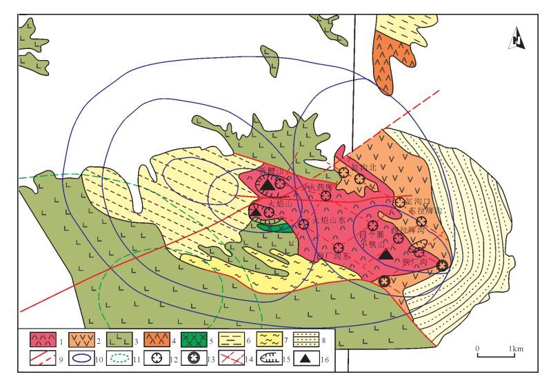
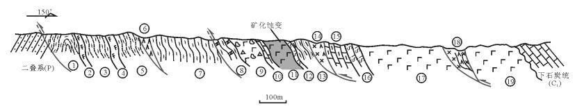
20世纪90年代以来,火山机构控矿理论在海相火山岩区块状硫化物矿床研究中得到了越来越多的关注,基于该理论的指导,在北祁连山东段的白银矿田取得了找矿突破性进展。其间,详细的海相火山岩相地质填图工作为白银矿田火山机构与成矿联系的研究及找矿突破奠定了坚实的基础。反映出在海相火山岩区推行合理可行的火山岩相地质填图方法至关重要。以白银矿田海相火山岩区为例,首先,对该区大比例尺火山岩相填图及古火山机构厘定成果进行介绍;其次,通过分析、借鉴此成功案例,总结海相火山岩区填图内容和技术方法;最后,阐述应用该方法在北祁连山中段祁连县一带海相火山岩区进行大比例尺填图的成功尝试。
Abstract:Since the end of the 1990s, the theory that paleovolcanic apparatus can dominate massive sulfide deposit in marine volcanic terrain has attracted more and more attention. Based on this theory, great progress for mineral exploration has been made in the Baiyin orefield located in the eastern part of the North Qilian Mountain. Meanwhile, exploration of the mapping method based on volcanic rock facies has laid the foundation for recognizing the paleovolcanic edifices and mineral exploration. Thus, it should be very important to employ reasonable methods for mapping in the marine volcanic terrain. In this paper, firstly the authors analyzed the paleovolcanic apparatus of the Baiyin orefield and introduced the achievement of large-scale mapping. Then, based on an analysis of the successful case, the authors summed up the contents and methods for mapping in the marine volcanic terrain. At last, guided by the method, the authors provided two successful examples of mapping work in the region near the Qilian County, which is located in the middle part of the North Qilian Mountain.
-
Key words:
- marine volcanic terrain /
- mapping method /
- Baiyin orefield /
- paleovolcanic edifices
-

-
[1] 夏林圻, 夏祖春, 任有祥, 等.祁连山及邻区火山作用与成矿[M].北京:地质出版社, 1996.
[2] 李向民, 彭礼贵.白银矿田含矿围岩蚀变特征及其意义[J].西北地质, 1998, (2):10-18. http://www.cqvip.com/QK/93232X/199802/3065720.html
[3] 彭礼贵, 任有祥, 李智佩.甘肃白银厂铜多金属矿床成矿模式[M].北京:地质出版社, 1995.
[4] 邬介人, 任秉琛, 黄玉春, 等.西北海相火山岩地区块状硫化物矿床[M].武汉:中国地质大学出版社, 1994.
[5] 李向民, 彭礼贵, 任有祥.白银厂式块状硫化物矿床找矿突破的反思[J].西北地质, 2003, 36(2):77-82. http://industry.wanfangdata.com.cn/dl/Detail/Periodical?id=...
[6] 李向民.甘肃白银矿田东部矿床成矿和找矿模式[M].北京:地质出版社, 2000.
[7] 谢家莹.试论陆相火山岩区火山地层单位与划分——关于火山岩区填图单元划分的讨论[J].资源调查与环境, 1996, (3):85-94. http://www.cqvip.com/QK/95903A/199603/2413648.html
[8] 傅树超, 卢清地.陆相火山岩区填图方法研究新进展——"火山构造-岩性岩相-火山地层"填图方法[J].地质通报, 2010, 29(11):1640-1648. http://dzhtb.cgs.cn/ch/reader/view_abstract.aspx?flag=1&file_no=20101106&journal_id=gbc
[9] 马金清, 李进堂, 冯宗帜.火山构造组合研究和地质填图方法——以福建闽清测区1:5万区域地质调查为例[J].中国区域地质, 2000, 19(2):198-204. http://doi.wanfangdata.com.cn/10.3969/j.issn.1671-2552.2000.02.016
[10] 李智佩, 彭礼贵, 任有祥, 等.碎斑熔岩在黑矿型矿床成矿作用中的地位[J].西北地质科学, 1998, (1):59-67. http://www.cnki.com.cn/Article/CJFDTOTAL-XBFK199801002.htm
[11] 陶奎元, 黄光昭, 王美星, 等.中国东南部碎斑熔岩基本特征及成因机理的探讨[J].资源调查与环境, 1985, (1):3-23. http://www.cnki.com.cn/Article/CJFDTOTAL-HSDZ198501000.htm
[12] 地质矿产部区域地质矿产地质司.火山岩地区区域地质调查方法指南[M].北京:地质出版社, 1987.
[13] 王德滋, 周新民.火山岩岩石学[M].北京:科学出版社, 1982.
[14] 邱家骧.火山岩相及其主要特征[J].地质科技情报, 1984, (2):49-56.
[15] 陈先沛, 高计元, 陈多福, 等.热水沉积作用的概念和几个岩石学标志[J].沉积学报, 1992, (3):124-132.
[16] 许东禹.太平洋中部多金属结核及其形成环境[M].北京:地质出版社, 1994.
-
 下载:
下载:


图(4)
计量
- 文章访问数: 382
- PDF下载数: 4
- 施引文献: 0