Analysis of 6.10 water and mud inrush incident in the exit of parallel pilot tunnel of Chaoyang tunnel of Guiyang-Nanning high-speed railway
-
摘要:
2018年6月10日,朝阳隧道出口平导发生岩溶突水突泥,持续时间约1 h,突水突泥总量约1.6×10⁶ m3。为完善施工掘进方案及排水方案,需分析突水突泥产生原因,评价后续施工带来的突水突泥风险,计算隧道涌水量。文章分析了隧道位置的地形地貌、工程地质、水文地质条件,阐述了发生突水突泥的平导掌子面超前地质预报实施情况及突水突泥发生过程,补充调查了灾害影响范围的工程地质、水文地质条件,完成了长达1年的平导涌水量-降雨量关系动态观测。平导突水突泥掌子面前方有水头高达84 m的巨型溶腔及管道系统,施工开挖揭穿溶腔底部后,填充于整个岩溶水系统的有压水流携带泥砂快速涌入平导并以较大动能冲出洞外,导致了6.10突水突泥事件的发生。隧道出口段岩溶水系统接受降雨入渗补给且径流通畅,洞内涌水对应的汇水面积为6.423 km2,计算极端暴雨后平导最大涌水量5×10⁴ m3·h−1。突水突泥发生后山体内的静储量已得到充分释放,地下水位已降至平导底板高程,后续施工中再遭遇突水突泥的风险低。
Abstract:A high-speed railway running 350 km·h−1 is being built between Guiyang in Guizhou Province and Nanning in Guangxi. Chaoyang tunnel is a double-track single-hole tunnel located in southeastern Guizhou. The tunnel clearance is 100 m2 with the total length of 12,734 m (including more than 7-km-long soluble rock), and its maximum burial depth is 386 m. The railroad track elevation of the tunnel is 782-468 m, and it gradually decreases from the entrance to the exit, with a slope of −22.7‰ to −25‰. An auxiliary tunnel scheme of "2 transverse tunnels +2 parallel pilot tunnels +1 inclined shaft" has been adopted, with the parallel pilot tunnel on the left side of the main tunnel. The midline of the parallel pilot tunnel is 30 m away from the main tunnel, and 3 m lower than the main hole. The inner headroom size is 5.0 m (width) ×6.0 m (height).
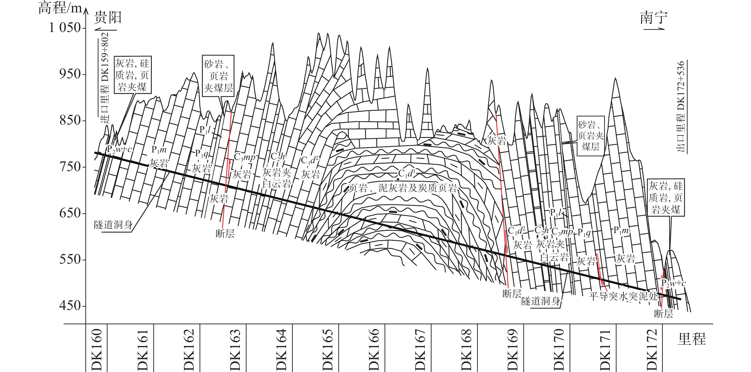
Construction of the tunnel began in early 2016 and will be completed in 2022. On June 10, 2018, karst water and mud inrush, lasting about 1 hour, occurred at the exit of parallel pilot tunnel of Chaoyang tunnel. The total amount of water and mud inrush was about 1.6×10⁶ m3. In order to complete the construction tunneling scheme and drainage scheme, it is necessary to analyze the causes of water and mud inrush, evaluate its risk in the subsequent construction, and calculate the water inflow of the tunnel. In this study area, the exit section of the tunnel is in the sloping medium-and-low mountainous area, belonging to the karst peak cluster landform, and the terrain fluctuates greatly. The tunnel passes th exit section of the tunnel is in the sloping medium and low mountainous area, belongs to the karst peak cluster landform with relatively sharp topographic relief. The tunnel passes through a regionally wide and gentle symmetrical anticline, and the exit of the tunnel is located on the southeastern wing of the anticline widely distributed by thick-to-extremely-thick bedded limestone with pure rock texture. Extreme development of surface karst funnels, dissolution basins, karst drop holes, karst caves and other phenomena provides favorable conditions for the collection, infiltration and runoff of surface water, but there is no long-term water system on the surface. After rainfall, the catchment of the non-soluble rock segment is mainly infiltrated through the contact zone between the soluble rock and the non-soluble rock, but the water catchment of the soluble rock section penetrates directly into the underground karst water system through the surface negative topography. Controlled by topography, geomorphology and transverse faults, except for the direction of groundwater seepage along the tectonic line in some sections, the infiltration groundwater is mainly discharged from the Zhangjiang river, which is basically perpendicular to the axis of the anticline and to the southeast wing (the exit of the tunnel). As a result, a series of transverse gullies and underground rivers cutting through the main structural lines were formed.
The present study is mainly focused on the following aspects: analyzing the topography, engineering geology and hydrogeology of the tunnel, introducing the implementation of advance geological prediction on the face of the parallel pilot tunnel, and describing the process of water and mud inrush. In this study, the engineering geology and hydrogeology conditions in the area affected by the disaster were investigated and a one-year dynamic observation of the relationship between water inflow and rainfall was also completed.
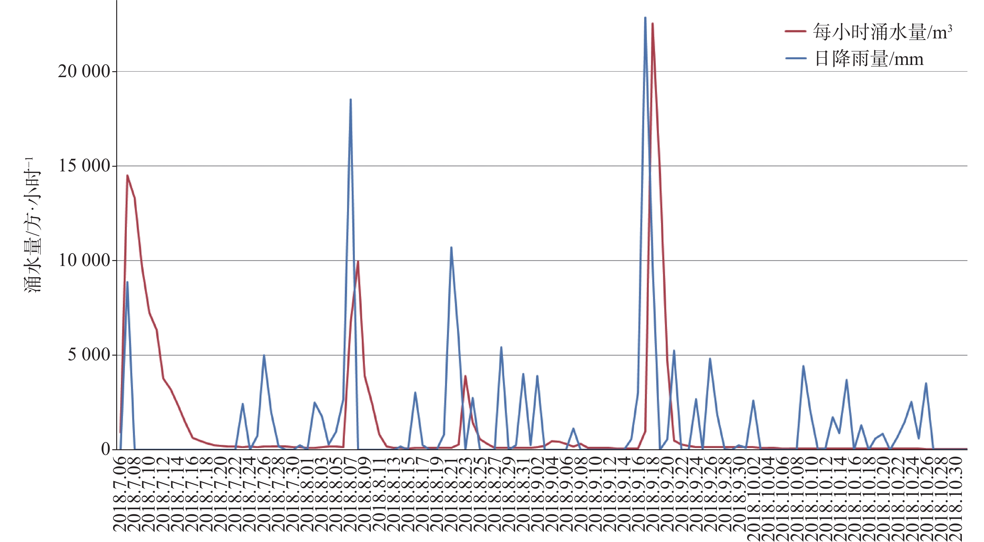
The research finding shows that a huge cavity and pipeline system with a water head of up to 84 m in front of the tunnel face caused the water and mud inrush. After excavation and exposing the bottom of the cavity, the pressurized water flow filling in the whole karst water system carried mud and sand rapidly into the tunnel face and rushed out of the parallel pilot tunnel with a large kinetic energy, resulting in the water and mud inrush event on June 10. In the process of this event, the surrounding karst water system was supplied in time, and the amount of water and mud inrush was much larger than the volume of large dissolution cavity near the tunnel face. The process of "water gushing-water shutoff-water gushing-water shutoff after dredging" occurred many times, indicating that the deposition in the lower part of the cavity is very serious and the drainage is not unobstructed. If the groundwater in the saturated cavity is not discharged effectively, the blasting excavation will cause serious water and mud inrush disaster. Long-term rainfall and water inflow monitoring shows that the karst water system at the exit of the tunnel receives rainfall infiltration recharge and the runoff is unobstructed. The catchment area corresponding to the water inrush to the tunnel is 6.423 km2, and the maximum water inrush in the tunnel after the extreme rainstorm is 5×10⁴ m3·h−1. After the occurrence of water and mud inrush, the static reserves in the mountain body have been fully released, and the groundwater level has dropped to the elevation of the tunnel floor. On the premise of ensuring the unobstructed drainage during the tunneling process, the risk of encountering water and mud inrush in the subsequent construction is low.
-
Key words:
- water and mud inrush /
- karst cavity /
- karst underground river /
- cause analysis /
- water inflow /
- Chaoyang tunnel
-

-
表 1 突水突泥前掌子面异常情况及探查过程
Table 1. Abnormal condition of tunnel face and exploration process before water and mud inrush
序号 日期 时间 降雨情况 勘探情况 预报结论及异常情况 1 5月24日 地震
物探PDK170+724掌子面实施TSP法超前地质预报:PDK170+707、PDK170+683及PDK170+656附近、PDK170+624~+610段裂隙较发育或溶蚀夹泥,局部含水 2 5月26日 超前
钻探PDK170+709掌子面进行超前地质钻探作业,施作钻孔 1 个,总钻长 30 m:冲洗液呈灰白色,流量无变化,冲击声清脆,钻进无卡钻、突进现象,无水,岩性主要为灰岩,岩质硬 3 5月30日 4:30-
8:30无 超前
炮孔PDK170+674掌子面实施超前炮孔:底板中心钻孔出现浑浊水流,压力逐渐增大,喷射约10 m,6时许水由浊变清,8时30分停止出水 4 9:00-
12:00无 超前
炮孔PDK170+674掌子面补钻剩余超前炮孔:底板中心偏右及右侧2个钻孔出现浑浊水流,喷射约10 m,至12点水色变清但水量、水压一直未减;之后又在出水点上方水平钻孔探测,共钻孔8个,其中3个孔在底板上约40 cm处出浑浊水流,喷射距离15~20 m,涌水量744 m3·h−1,水量未见减小但有变清趋势 5 5月31日 持续
降雨地质
雷达PDK170+674掌子面实施了地质雷达探测: PDK170+669.5~+667段裂隙或溶蚀较发育-发育,含水;PDK170+662附近及PDK170+652~+649段掌子面右侧裂隙或溶蚀较发育 6 5月31日~
6月1日持续
降雨无 PDK170+674掌子面:5月31日上午,洞内流量570 m3·h−1;至6月1日,逐步增大至1 100 m3·h−1后趋于稳定 7 6月3日 0:50 无 无 PDK170+674掌子面:所有出水孔全部停止出水,近段时间总出水量估算大约10×104 m3 8 11:40-
15:40无 爆破
开挖现场实施爆破开挖,开挖进尺为3 m,掌子面推进至PDK170+671;13时50分出碴结束时突发涌水涌泥(两小时内涌水涌泥约3×10⁴ m3),15时40分停止涌水涌泥,仅剩少量水缓慢流出,水量、水质稳定 9 6月5日-
6月7日无 清淤 PDK170+671掌子面:6月5日12时开始清淤, 6月7日清出掌子面,在底板右侧见一宽约2 m、高约0.5 m的溶洞,有少量水缓慢流出,无压力 10 6月8日 无 地质
雷达PDK170+671掌子面:预报里程范围为PDK170+671~+641:PDK170+667~+663段及PDK170+660附近裂隙或溶蚀较发育,局部含水 11 6月9日 21:12 无 超前
钻孔PDK170+671掌子面:在底板上1 m位置进行超前水平钻孔,向正洞方向夹角45°钻孔钻至5.5 m时,夹钻无法继续钻进;边墙位置向正洞方向钻孔,钻至9 m时,夹钻无法继续钻进 12 6月10日 8:30 无 PDK170+671掌子面:掌子面出水点缓缓流水,水量水质未变化,无压力 -
[1] 陈宏峰, 张发旺, 何愿, 夏日元, 邹胜章, 苏春田, 罗书文. 地质与地貌条件对岩溶系统的控制与指示[J]. 水文地质工程地质, 2016, 43(5):42-46.
CHEN Hongfeng, ZHANG Fawang, HE Yuan, XIA Riyuan, ZOU Shengzhang, SU Chuntian, LUO Shuwen. Geological and geomorphologic settings acting as the controlling factors and indicators for karst systems[J]. Hydrogeology & Engineering Geology, 2016, 43(5):42-46.
[2] 孙谋, 刘维宁. 高风险岩溶隧道掌子面突水机制研究[J]. 岩土力学, 2011, 32(4):1175-1180. doi: 10.3969/j.issn.1000-7598.2011.04.037
SUN Mou, LIU Weining. Research on water inrush mechanism induced by karst tunnel face with high risk[J]. Rock and Soil Mechanics, 2011, 32(4):1175-1180. doi: 10.3969/j.issn.1000-7598.2011.04.037
[3] 资谊, 马士伟. 岩溶隧道涌突水灾害发生机理与工程防治[J]. 铁道工程学报, 2011(2):84-89. doi: 10.3969/j.issn.1006-2106.2011.02.017
ZI Yi, MA Shiwei. Occurrence mechanism and prevention of water-bursting hazard for karst[J]. Journal of Railway Engineering society, 2011(2):84-89. doi: 10.3969/j.issn.1006-2106.2011.02.017
[4] 李术才, 王康, 李利平, 周宗青, 石少帅, 柳尚. 岩溶隧道突水灾害形成机理及发展趋势[J]. 力学学报, 2017, 49(1):22-29. doi: 10.6052/0459-1879-16-345
Li Shucai, Wang Kang, Li Liping, Zhou Zongqing, Shi Shaoshuai, Liu Shang. Mechanical mechanism and development trend of water-inrush disasters in karst tunnels[J]. Chinese Journal of Theoretical and Applied Mechanics, 2017, 49(1):22-29. doi: 10.6052/0459-1879-16-345
[5] 李术才,许振浩,黄鑫,林鹏,赵晓成,张庆松,杨磊,张霄,孙怀凤,潘东东. 隧道突水突泥致灾构造分类、地质判识、孕灾模式与典型案例分析[J]. 岩石力学与工程学报, 2018, 37(5):1041-1069. doi: 10.13722/j.cnki.jrme.2017.1332
LI Shucai, XU Zhenhao, HUANG Xin, LIN Peng, ZHAO Xiaocheng, ZHANG Qingsong, YANG Lei, ZHANG Xiao, SUN Huaifeng, PAN Dongdong. Classification, geological identification, hazard mode and typical case studies of hazard-causing structures for water and mud inrush in tunnels[J]. Chinese Journal of Rock Mechanics and Engineering, 2018, 37(5):1041-1069. doi: 10.13722/j.cnki.jrme.2017.1332
[6] 李芳涛, 李华明, 胡志平, 陈南南, 晏长根. 峨汉高速廖山隧道岩溶发育规律及其工程效应浅析[J]. 中国岩溶, 2020, 39(4):592-603.
LI Fangtao, LI Huangming, HU Zhiping, CHEN Nannan, YAN Changgen. Features of karst development and geotechnical effects in the Liaoshan Tunnel on the E-Han Expressway[J]. Carsologica Sinica, 2020, 39(4):592-603.
[7] 任亚楠, 万军伟, 黄琨, 何欣慧. 云南万寿山地区岩溶水系统特征及隧道选线研究[J]. 中国岩溶, 2020, 39(4):604-613.
REN Yanan, WAN Junwei, HUANG Kun, HE Xinhui. Study on the characteristics of karst water system and tunnel route selection in Wanshoushan area, Yunnan Province[J]. Carsologica Sinica, 2020, 39(4):604-613.
[8] 张桥. 小三峡岩溶隧道围岩防突层安全厚度有限元分析[J]. 中国岩溶, 2020, 39(4):614-621.
ZHANG Qiao. Finite element analysis on safety thickness of the inrush prevention layer in rock beds of the Small Three Gorges karst tunnel[J]. Carsologica Sinica, 2020, 39(4):614-621.
[9] 李潇, 漆继红, 许模. 西南典型紧窄褶皱小尺度浅层岩溶水系统特征及隧道涌水分析[J]. 中国岩溶, 2020, 39(3):375-383.
LI Xiao, QI Jihong, XU Mo. Analysis on the characteristics of small-scale shallow karst water systems in typical tight-narrow folds and tunnel water inrush in Southwestern China[J]. Carsologica Sinica, 2020, 39(3):375-383.
[10] 贺华刚. 深埋特长隧道的突涌水危险性评价研究[J]. 中国岩溶, 2020, 39(3):384-390.
HE Huagang. Assessment of water inrush risk in deep buried long tunnels[J]. Carsologica Sinica, 2020, 39(3):384-390.
[11] 郑克勋, 裴熊伟, 朱代强, 吴述彧, 郭维祥. 岩溶地区地下水位变动带隧道涌水问题的思考[J]. 中国岩溶, 2019, 38(4):473-479.
ZHENG Kexun, PEI Xiongwei, ZHU Daiqiang, WU Shuyu, GUO Weixiang. Thoughts on tunnel water inrush in changing zones of groundwater level in karst areas[J]. Carsologica Sinica, 2019, 38(4):473-479.
[12] 何桥, 朱代强, 郑克勋, 朱建耘, 黄勇. 深埋特长隧道岩溶高压涌水灌浆封堵技术研究与实践[J]. 中国岩溶, 2019, 38(4):488-495.
HE Qiao, ZHU Daiqiang, ZHENG Kexun, ZHU Jianyun, HUANG Yong. Application of grouting sealing technology on karst high-pressure water inrush in a deep-buried extra-long tunnel[J]. Carsologica Sinica, 2019, 38(4):488-495.
[13] 庄旭峰, 孙东. 实例分析隧道建设对岩溶水的影响[J]. 中国岩溶, 2016, 35(6):681-687.
ZHUANG Xufeng, SUN Dong. Influence of tunnel construction on karst water: Case analyses[J]. Carsologica Sinica, 2016, 35(6):681-687.
[14] 张可能, 张岳, 廖阳, 万浩然, 许培浩, 张云毅. 贵阳某地铁车站岩溶发育特征及突水模式分析[J]. 中国岩溶, 2018, 37(2):300-306.
ZHANG Keneng, ZHANG Yue, LIAO Yang, WAN Haoran, XU Peihao, ZHANG Yunyi. Analysis on karst development and water burst in a subway station[J]. Carsologica Sinica, 2018, 37(2):300-306.
[15] 陈国亮. 岩溶工程地质[M]. 北京: 中国铁路出版社, 1984: 86-93.
CHEN Guoliang. Karst engineering geology[M]. Beijing: China Railway Publishing House, 1984: 86-93.
[16] 毛邦燕, 许模, 蒋良文. 隧道岩溶突水、突泥危险性评价初探[J]. 中国岩溶, 2010, 29(2):183-189. doi: 10.3969/j.issn.1001-4810.2010.02.013
MAO Bangyan, XU Mo, JIANG Liangwen. Preliminary study on risk assessment of water and mud inrush in karst tunnel[J]. Carsologica Sinica, 2010, 29(2):183-189. doi: 10.3969/j.issn.1001-4810.2010.02.013
-


 下载:
下载:


