

Database of 1∶50 000 Mineral Geological Map of the Suolong Map-sheet in Zhaishang–Mawu Gold Deposit, Minxian County, Gansu Province
-
摘要:
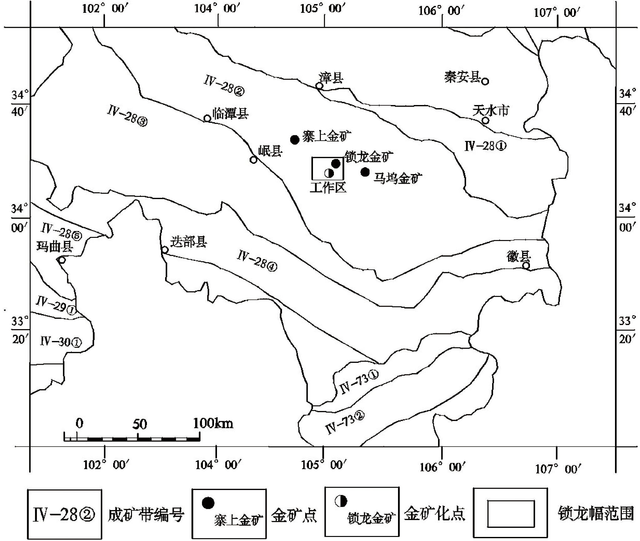
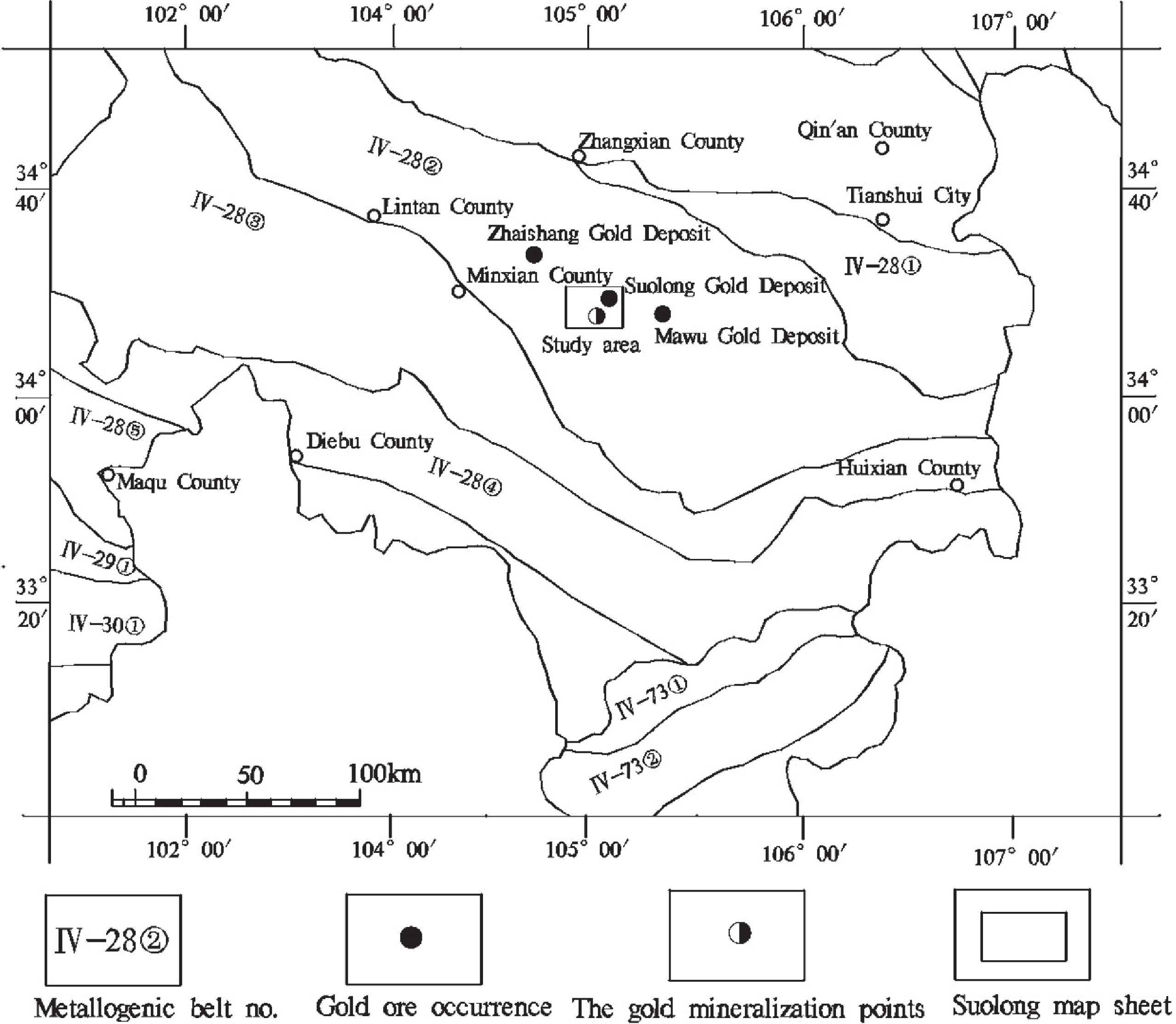
甘肃省岷县寨上—马坞金矿锁龙幅 (I48E010011)1∶50 000矿产地质图是根据《固体矿产地质调查技术要求(1∶50 000)》和行业的统一标准及要求,在充分利用1∶50 000区域地质调查、区域矿产调查等工作成果资料的基础上,采用数字填图系统进行野外地质专项填图,并应用室内与室外填编图相结合的方法完成的。本图对前泥盆系吴家山组、泥盆系大草滩组、石炭系巴都组、二叠系十里墩组的沉积建造类型进行了重新划分,并把图幅内侵入岩时代归纳为晚三叠纪、早二叠纪2期,建立了岩浆岩的演化序列。图幅内金成矿与二叠纪地层关系密切,大多矿床(点)产于十里墩组裂隙较为发育的碎屑岩中。本数据库包含7个地层单位和2期岩浆岩资料,光薄片212件,化学样192件,基岩光谱486件,土壤样2793件,Ar/Ar测年2件,流体包裹体测温8件,岩石化学分析样15件,调查区内发现金矿体3条、矿化点1处,估算(334)金金属量5.32 t。数据量约17.4 MB,充分反映了1∶50 000矿产地质调查示范性成果,对该区矿产资源研究、能源勘探等具参考意义。
Abstract:The 1∶50 000 mineral geological map of the Suolong Map-sheet (I48E010011) in Zhaishang–Mawu Gold Deposit in Minxian County, Gansu Province was developed in accordance with the Technical Requirements of Solid Mineral Geological Survey (1∶50 000) and other unified standards and requirements in the geological industry, during which the results obtained from previous 1∶50 000-scale regional geological surveys and 1∶50 000-scale regional mineral surveys were fully utilized. Meanwhile, the digital mapping system was adopted for field geology-specific mapping, and indoor map compilation was conducted along with field mapping. In this map, the sedimentary suite types of the pre-Devonian Wujiashan and Dacaotan Formations, Carboniferous Badu Formation, and Permian Shilidun Formation are reclassified, the formation epochs of the intrusions are classified into Late Triassic and Early Permian, and the evolutionary sequence of magmatic rocks is established. The gold metallogenesis in this Map-sheet is closely related to Permian strata, and most deposits (ore occurrences) occurred in clastic rocks of the Shilidun Formation with relatively developed fissures. The database of the 1∶50 000 mineral geological map (also referred to as the Database) includes the data of seven stratigraphic units and two stages of magmatic rocks, and covers 212 polished thin sections, 192 chemical samples, 486 bedrock spectra, 2793 soil samples, two samples for Ar/Ar dating, eight samples for fluid inclusion thermometry, and 15 samples for petrochemical analysis. Meanwhile, three gold ore bodies and one gold mineralized point were newly discovered in the study area, with estimated (334) gold of 5.32 tonnes. Having a data size of about 17.4 MB, the Database fully reflects the demonstration results of 1∶50 000 mineral geological surveys, and could provide references for mineral resource research and energy exploration in this Map-sheet area.
-

-
表 1 数据库(集)元数据简表
条目 描述 数据库(集)名称 甘肃省锁龙幅1∶50 000矿产地质图数据库 数据库(集)作者 沉积岩类:邓辉,甘肃省地矿局第二地质矿产勘查院
变质岩类:邓辉,甘肃省地矿局第二地质矿产勘查院
侵入岩类:赵得龙,甘肃省地矿局第二地质矿产勘查院数据时间范围 2016—2017年 地理区域 经纬度:东经104°30′~104°45′,北纬34°20′~34°30′ 数据格式 *.wl, *.wt, *.wp 数据量 17.4 MB 数据服务系统网址 http://dcc.cgs.gov.cn 基金项目
语种中国地质调查局地质调查项目“整装勘查区找矿预测与技术应用示范” (项目编号:121201004000150017-32)资助
中文数据库(集)组成 锁龙幅1∶50 000矿产地质图数据库包括1∶50 000地质图库、角图和整饰。地质图库包括沉积岩、岩浆岩、变质岩、第四系、构造、地质界线、产状、矿床(点)、蚀变、岩性花纹、各类代号等。角图部分包括沉积岩建造、侵入岩建造、变质岩建造、脉岩、构造、图切剖面图、典型矿床(区)平面图、重要勘探线剖面图、地质剖面图及创新性角图、矿产图例、矿产地名录、矿化蚀变图例、成矿区(带)位置图。整饰部分包括接图表、中国地质调查局局徽、图名、比例尺、坐标参数、责任签等  下载: 导出CSV
表 2 锁龙幅矿产地质图沉积岩建造数据属性表
序号 数据项名称 标准编码 数据类型 实例 1 图幅号 Mapcode 字串符 I48E010011 2 岩性名称 Litho 字串符 土黄—黄褐色石英砂岩,黄褐色泥质板岩 3 地层代号 Strapha 字串符 P1sl1qu 4 时代 Geoname 字串符 二叠系下统十里墩组下段 5 地质体代码 Type_Code 字串符 YSAC2 6 符号代码 Sign_Code 字串符 0404
下载: 导出CSV
表 3 锁龙幅矿产地质图侵入岩建造数据属性表
序号 数据项名称 标准编码 数据类型 实例 1 图幅号 Mapcode 字串符 I48E010011 2 岩性名称 Litho 字串符 中细粒含斑黑云二长花岗岩 3 地质代号 Strapha 字串符 TLηγβ 4 时代 Geoname 字串符 中生代三叠纪 5 地质体代码 Type_Code 字串符 YSAC1 6 符号代码 Sign_Code 字串符 0401
下载: 导出CSV
表 4 锁龙幅矿产地质图变质岩建造数据属性表
序号 数据项名称 标准编码 数据类型 实例 1 图幅号 Mapcode 字串符 I48E010011 2 岩性名称 Litho 字串符 灰黑—灰色板岩 3 地层代号 Strapha 字串符 P1sl1sl 4 时代 Geoname 字串符 二叠系下统十里墩组下段 5 地质体代码 Type_Code 字串符 YSAC2 6 符号代码 Sign_Code 字串符 0404
下载: 导出CSV
表 5 锁龙幅矿产地质图断裂构造数据属性表
序号 数据项名称 标准编码 数据类型 实例 1 图幅号 Mapcode 字串符 I48E010011 2 断层编号 Line_Code 字串符 F25 3 右侧填图单位 Right_Body 字串符 P1sl1ssl 4 左侧填图单位 Left_Body 字串符 P1sl1ssl 5 断层性质 Type 字串符 正断层 6 断层走向/° Trend 字串符 61 7 断层倾向/° Dip 字串符 151 8 断层面倾角/° Dip_Ang 字串符 80 9 接触关系 Relation 字串符 断层接触
下载: 导出CSV
表 6 锁龙幅矿产地质图产状数据属性表
序号 数据项名称 标准编码 数据类型 实例 1 路线号 Routecode 字串符 L5001 2 地质点号 Geopoint 字串符 D5003 3 产状类型名称 Type 字串符 层理 4 产状走向/° Trend 字串符 80 5 产状倾向/° Dip 字串符 350 6 产状倾角/° Dip_Ang 字串符 75
下载: 导出CSV
表 7 锁龙幅矿产地质图矿产地数据属性表
序号 数据项名称 标准编码 数据类型 实例 1 矿种名称 Commodities_Name 字串符 Au 2 矿产地数 Ore_Sums 整数型 1 3 矿石品位 Ore_Grade 字串符 Au 1.44 g/t 4 规模 Deposite_Size 字串符 中型矿床 5 成矿时代 Metallogenetic_Epoch 字串符 三叠纪 6 矿产地名 Placename 字串符 锁龙金矿 7 矿化类型 Genesis_Types 字串符 中低温热液型 8 成因类型 Industrial_Types 字串符 构造蚀变岩型
下载: 导出CSV
表 8 早泥盆世—晚二叠世陆表海盆地构造演化阶段岩石地层单位
年代地层 岩石地层单位 地层代号 岩石组合特征 二叠系 上统 大关山组 下段 P2dg1 (sl+mls) 黄褐色粉砂质板岩与青灰色微晶灰岩互层,偶见浅黄色泥质板岩、灰色结晶灰岩 P2dg1ss 灰白色含砾石英砂岩、砂砾岩 P2dg1qu 黄褐色石英砂岩,偶见浅灰色石英细砂岩 下统 十里墩组 上段 P1sl2ssl 粉砂质板岩 P1sl2sl 泥质板岩、硅质板岩,偶夹薄层微晶灰岩 下段 P1sl1qu 土黄—黄褐色石英砂岩,偶见黄褐色泥质板岩 P1sl1ds 灰色岩屑石英砂岩,偶夹灰白色石英砂岩 P1sl1ssl 黑色粉砂质板岩,该层是构造蚀变岩型金矿主要的赋矿岩性层 P1sl1 (ds+sl) 灰白—灰黑色岩屑石英砂岩与灰黑色板岩互层,该层是构造蚀变岩型金矿主要的赋矿岩性层 P1sl1sl 灰黑—灰色板岩 石炭系 上统 下加岭组 上段 C2x2ls 砂屑灰岩、含生物碎屑砂屑灰岩夹泥灰岩、含炭质板岩组成的韵律层 下段 C2x1st 褐灰色钙质岩屑砂岩、钙质粉砂岩、石英砂岩 下统 巴都组 C1b (ss+sl) 深灰色中层长石石英砂岩、石英砂岩、粉砂质板岩等 泥盆系 上统 大草滩组 上岩段 D3d2st 紫红色中薄层状粉砂岩、泥岩夹灰绿色中层状含细砾长石石英砂岩、石英砂岩互层 下岩段 D3d1fq 灰绿色中厚层状长石石英砂岩、粉砂岩夹紫红色粉砂质泥岩或泥岩互层 下统 黄家沟组 二段 D1h2qu 灰白色中厚层状石英砂岩建造
下载: 导出CSV
Table 1. Metadata Table of Database (Dataset)
Item Description Database (dataset) name 1∶50 000 Mineral Geologic Map of the Suolong Map-sheet, Gansu Province Database (dataset) authors Sedimentary rocks: Deng Hui, The Second Geological Mineral Exploration Institute of Gansu Provincial Geology and Mineral Bureau
Metamorphic rocks: Deng Hui, The Second Geological Mineral Exploration Institute of Gansu Provincial Geology and Mineral Bureau
Intrusive rocks: Zhao Delong, The Second Geological Mineral Exploration Institute of Gansu Provincial Geology and Mineral BureauData acquisition time 2016–2017 Geographical area 104°30′−104°45′E; 34°20′−34°30′N Data formats *.wl, *.wt, *.wp Data size 17.4 MB Data service system URL http://dcc.cgs.gov.cn Fund project The project titled Prospecting Prediction and Technological Application Demonstration of Integrated Exploration Areas (No.: 121201004000150017-32) initiated by the China Geological Survey Language Chinese Database (dataset) composition The mineral geological map database of the Suolong Map-sheet consists of a map library, corner maps, and map decorations. The map library covers sedimentary rocks, magmatic rocks, metamorphic rocks, the Quaternary, structures, geologic boundaries, attitude, deposits (ore occurrences), alternation, lithologic patterns, and various geologic codes. The corner maps involve the sedimentary rock suites, intrusion suites, metamorphic rock suites; vein rocks, structures, cross-sections, plans of typical deposits (mining areas), major exploration line sections, geological sections, innovative corner maps, mineral legends, deposit list, mineralized alternation legends, and the map of metallogenic zone/belt locations. The map decorations include an index map, the logo of the China Geological Survey, map name, scale, coordinate parameters, and signatures
下载: 导出CSV
Table 2. Data attributes of sedimentary rock suites on the 1∶50 000 mineral geological map of Suolong Map-sheet
No. Data item Standard code Data type Example 1 Map-sheet no. Mapcode string I48E010011 2 Lithologic name Litho string Earth yellow−yellowish brown quartz sandstone, and yellowish brown argillaceous slate 3 Stratigraphic code Strapha string P1sl1qu 4 Era Geoname string Lower member of Lower Permian Shilidun Formation 5 Geologic block code Type_Code string YSAC2 6 Symbol code Sign_Code string 0404
下载: 导出CSV
Table 3. Data attributes of intrusive rock suites on the 1∶50 000 mineral geological map of Suolong Map-sheet
No. Data item Standard code Data type Example 1 Map-sheet no. Mapcode string I48E010011 2 Lithologic name Litho string Medium-fine grained porphyritic biotite monzonitic adamellite 3 Stratigraphic code Strapha string TLηγβ 4 Era Geoname string Triassic (Mesozoic) 5 Geologic block code Type_Code string YSAC1 6 Symbol code Sign_Code string 0401
下载: 导出CSV
Table 4. Data attributes of metamorphic rock suites on the 1∶50 000 mineral geological map of Suolong Map-sheet
S. No. Data item Standard code Data type Example 1 Map-sheet no. Mapcode string I48E010011 2 Lithologic name Litho string Greyish black – gray slate 3 Stratigraphic code Strapha string P1sl1sl 4 Era Geoname string Lower member of Lower Permian Shilidun Formation 5 Geologic block code Type_Code string YSAC2 6 Symbol code Sign_Code string 0404
下载: 导出CSV
Table 5. Data attributes of fault structures on the 1∶50 000 mineral geological map of Suolong Map-sheet
S. No. Data item Standard code Data type Example 1 Map-sheet no. Mapcode string I48E010011 2 Fault no. Line_Code string F25 3 Mapping units of the right side Right_Body string P1sl1ssl 4 Mapping units of the left side Left_Body string P1sl1ssl 5 Fault nature Type string Normal fault 6 Fault strike /° Trend string 61 7 Fault dip /° Dip string 151 8 Dip angel of fault surface/° Dip_Ang string 80 9 Contact relationship Relation string Fault contact
下载: 导出CSV
Table 6. Data attributes of attitude on the 1∶50 000 mineral geological map of Suolong Map-sheet
S. No. Data item Standard code Data type Example 1 Route no. Routecode string L5001 2 Geological point no. Geopoint string D5003 3 Attitude type name Type string Bedding 4 Attitude strike/° Trend string 80 5 Attitude dip/° Dip string 350 6 Attitude dip angle/° Dip_Ang string 75
下载: 导出CSV
Table 7. Data attributes of mineral deposits on the 1∶50 000 mineral geological map of Suolong Map-sheet
S. No. Data item Standard code Data type Example 1 Mineral type name Commodities_Name string Au 2 Mineral deposit sum Ore_Sums int 1 3 Ore grades Ore_Grade string Au 1.44 g/t 4 Scale Deposite_Size string Medium-sized deposit 5 Metallogenic epochs Metallogenetic_Epoch string Triassic 6 Deposit name Placename string Suolong gold deposit 7 Mineralization types Genesis_Types string Medium-low temperature hydrothermal type 8 Genetic types Industrial_Types string Tectonic altered rock type
下载: 导出CSV
Table 8. Lithostratigraphic units in the tectonic evolutionary stage of epicontinental-sea basins from Early Devonian to Late Permian
Epoch Lithostratigraphic unit Stratum code Rock association Permian Upper Daguanshan Formation Lower member P2dg1 (sl+mls) Alternating layers consisting of yellowish brown silty slate and caesious micrite, with light-yellow argillaceous slate and gray crystalline limestone occasionally visible P2dg1ss Hoary gravel-bearing quartz sandstone and sandy conglomerate P2dg1qu Yellowish brown quartz sandstone, with light gray fine-grained quartz sandstone occasionally visible Lower Shilidun Formation Upper member P1sl2ssl Silty slate P1sl2sl Argillaceous and siliceous slate, occasionally interbedded with thin laminated microcrystalline limestone Lower member P1sl1qu Earth yellow–yellowish brown quartz sandstone, with yellowish brown argillaceous slate occasionally visible P1sl1ds Gray lithic quartz sandstone, occasionally interbedded with grayish-white quartz sandstone P1sl1ssl Black silty slate, serving as the main ore-hosting lithologic layers of tectonic altered rock type of gold deposits P1sl1 (ds+sl) Alternating layers consisting of grayish-white–grayish-black lithic quartz sandstone and grayish-black slate, serving as the main ore-hosting lithologic layers of tectonic altered rock type of gold deposits P1sl1sl Grayish-black−gray slate Carboniferous Upper Xiajialing Formation Upper member C2x2ls Rhythmites composed of calcarenite and bioclastic calcarenite interbedded with marl and carbonaceous slate Lower member C2x1st Brownish-gray calcareous lithic sandstone, calcareous siltstone, and quartz sandstone Lower Badu Formation C1b (ss+sl) Dark gray medium laminated feldspar-quartz sandstone, quartz sandstone, silty slate, etc. Devonian Upper Dacaotan Formation Upper member D3d2st Amaranthine medium-thin laminated siltstone and mudstone interbedded with grayish-green medium laminated alternating layers consisting of quartz sandstone and feldspar-quartz sandstone bearing fine gravel Lower member D3d1fq Mainly grayish-green medium-thick laminated feldspar-quartz sandstone and siltstone, interbedded with alternating layers consisting of amaranthine silty mudstone or mudstone Lower Huangjiagou Formation Second member D1h2qu A grayish-white medium-thick laminated quartz sandstone suite
下载: 导出CSV
-
[1] 陈义兵, 张国伟, 裴先治, 鲁如魁, 梁文天, 郭秀峰. 2010. 西秦岭大草滩群的形成时代和构造意义探讨[J]. 沉积学报, 28(3): 579−583. https://www.cnki.com.cn/Article/CJFDTOTAL-CJXB201003023.htm
[2] 邓辉, 赵得龙. 2020. 甘肃省锁龙幅1∶50 000矿产地质图数据库[DB/OL]. 地质科学数据出版系统. (2020-12-30). DOI: 10.35080/data.C.2020.P32.
[3] 冯益民, 曹宣铎, 张二朋, 胡云绪, 潘晓萍, 杨军录, 贾群子, 李文明. 2003. 西秦岭造山带的演化、构造格局和性质[J]. 西北地质, 36(1): 1−10. doi: 10.3969/j.issn.1009-6248.2003.01.001
[4] 刘建宏, 张新虎, 赵彦庆, 任丰寿. 2006. 西秦岭成矿系列、成矿谱系研究及其找矿意义[J]. 矿床地质, 25(6): 728−734. https://www.cnki.com.cn/Article/CJFDTOTAL-KCDZ200606008.htm
[5] 李福林, 吴发富, 王成刚, 程湘, 王建雄. 2015. 数字填图技术“PRB”过程质量控制及常见问题整改方法−以路线地质调查为例[J]. 地质与勘探, 50(4): 705−712. https://www.cnki.com.cn/Article/CJFDTOTAL-DZKT201504011.htm
[6] 裴先治, 李佐臣, 丁仨平, 李勇, 胡波, 刘会彬. 2005. 西秦岭天水地区岛弧型基性岩浆杂岩的地球化学特征及形成时代[J]. 中国地质, 32(4): 529−540. doi: 10.3969/j.issn.1000-3657.2005.04.001
[7] 喻万强, 阎凤增, 肖力, 葛良胜, 张文华, 黄辉. 2014. 甘肃省岷县寨上-马坞金矿整装勘查区研究进展[J]. 矿床地质, 33(增): 989−990. https://www.cnki.com.cn/Article/CJFDTOTAL-KCDZ2014S1497.htm
[8] 杨雨, 范国琳, 姚国金, 赵凤游, 俞伯达, 赵宗宣, 宋杰己, 孙继廉, 王建中, 蔡体梁, 吴京城, 刘述贤, 范文光, 王峻. 1997. 甘肃省岩石地层[M]. 武汉: 中国地质大学出版社.
[9] 余超, 张发荣, 李通国. 2017. 甘肃省重要矿产区域成矿规律研究[M]. 北京: 地质出版社.
[10] 叶天竺, 吕志成, 庞振山, 张德会, 刘士毅, 王全明, 刘家军, 程志中, 李超岭, 肖克炎, 甄世民, 杜泽忠, 陈正乐. 2014. 勘查区找矿预测理论与方法总论[M]. 北京: 北京大学出版社.
[11] 詹艳, 赵国泽, 王立凤, 王继军, 陈小斌, 赵凌强, 肖骑彬. 2014. 西秦岭与南北地震构造带交汇区深部电性结构特征[J]. 地球物理学报, 57(8): 2594−2607. doi: 10.6038/cjg20140819
[12] 张德贤, 曹汇, 束正祥, 鲁安怀. 2015. 西秦岭造山带夏河-合作地区印支期岩浆活动及成矿作用−以德乌鲁石英闪长岩和老豆石英闪长斑岩为例[J]. 中国地质, 42(5): 1257−1273. doi: 10.3969/j.issn.1000-3657.2015.05.007
[13] 张新虎, 刘建宏, 梁明宏, 田黎萍, 李通国, 赵彥庆. 2013. 甘肃省区域成矿及找矿[M]. 北京: 地质出版社.
[1] Chen Yibing, Zhang Guowei, Pei Xianzhi, Lu Rukui, Liang Wentian, Guo Xiufeng. 2010. Discussion on the formation age and tectonic implications of Dacaotan Group in West Qinling[J]. Acta Sedimentologica Sinica, 28(3): 579−583 (in Chinese with English abstract).
[2] Deng Hui, Zhao Delong. 2020. 1∶50 000 Mineral Geologic Map of the Suolong Map-sheet, Gansu Province[DB/OL]. Geoscientific Data & Discovery Publishing System. (2020-12-30). DOI: 10.35080/data.C.2020.P32.
[3] Feng Yimin, Cao Xuanduo, Zhang Erpeng, Hu Yunxu, Pan Xiaoping, Yang Junlu, Jia Qunzi, Li Wenming. 2003. Tectonic evolution framework and nature of the West Qinling Orogenic belt[J]. Northwestern Geology, 36(1): 1−10 (in Chinese with English abstract).
[4] Liu Jianhong, Zhang Xinhu, Zhao Yanqing, Ren Fengshou. 2006. A study of metallogenic series of West Qinling region in Gansu Province and its ore-prospecting significance[J]. Mineral Deposits, 25(6): 728−734 (in Chinese with English abstract).
[5] Li Fulin, Wu Fafu, Wang Chenggang, Cheng Xiang, Wang Jianxiong. 2015. Quality control in the process of “PRB” digital mapping and rectification methods for common problems: An example of route geological survey[J]. Geology and Exploration, 50(4): 705−712 (in Chinese with English abstract).
[6] Pei Xianzhi, Li Zuochen, Ding Saping, Li Yong, Hu Bo, Liu Huibin. 2005. Geochemical characteristics and zircon U-Pb ages of island-arc basic igneous complexes in the Tianshui area, West Qinling[J]. Geology in China, 32(4): 529−540 (in Chinese with English abstract).
[7] Yu Wanqiang, Yan Fengzeng, Xiao Li, Ge Liangsheng, Zhang Wenhua, Huang Hui. 2014. Research progress of Zaishang-Mawu gold mine integrated exploration area in Minxian, Gansu province[J]. Mineral Deposits, 33(suppl.): 989−990 (in Chinese).
[8] Ye Tianzhu, Lyu Zhicheng, Pang Zhenshan, Zhang Dehui, Liu Shiyi, Wang Quanming, Liu Jiajun, Cheng Zhizhong, Li Chaoling, Xiao Keyan, Zhen Shimin, Du Zezhong, Chen Zhengle. 2014. Theories and methods of prospecting prediction in prospecting areas (general)[M]. Beijing: Geological Publishing House (in Chinese).
[9] Yang Yu, Fan Guolin, Yao Guojin, Zhao Fengyou, Yu Boda, Zhao Zongxuan, Song Jieji, Sun Jilian, Wang Jianzhong, Cai Tiliang, Wu Jingcheng, Liu Shuxian, Fan Wenguang, Wang Jun. 1997. Petrostratigraphy in Gansu Province[M]. Wuhan: China University of Geosciences Press (in Chinese).
[10] Yu Chao, Zhang Farong, Li Tongguo. 2017. Study on metallogenic regularities of important mineral regions in Gansu Province[M]. Beijing: Geological Publishing House (in Chinese).
[11] Zhan Yan, Zhao Guoze, Wang Lifeng, Wang Jijun, Chen Xiaobin, Zhao Lingqiang, Xiao Qibin. 2014. Deep electric structure beneath the intersection area of West Qinling orogenic zone with North-South Seismic tectonic zone in China[J]. Chinese Journal of Geophysics, 57(8): 2594−2607 (in Chinese with English abstract).
[12] Zhang Dexian, Cao Hui, Shu Zhengxiang, Lu Anhuai. 2015. Indosinian magmatism and tectonic setting of Xiahe-Hezuo area, western Qinling Mountains—implications from the Dewulu quartz diorite and Laodou quartz dioritic porphyry[J]. Geology of China, 42(5): 1257−1273 (in Chinese with English abstract).
[13] Zhang Xinhu, Liu Jianhong, Liang Minghong, Tian Liping, Li Tongguo, Zhao Yanqing. 2013. Regional mineralization and prospecting in Gansu Province[M]. Beijing: Geological Publishing House(in Chinese).
-

图(4)
表(16)
计量
- 文章访问数: 2241
- PDF下载数: 134
- 施引文献: 0