Dataset of 1∶50 000 Mineral Resource Potential Assessment of Gold–Antimony Deposit Integrated Exploration Area in Yawan–Daqiao Area, Gansu Province
-
摘要:
甘肃崖湾—大桥地区金锑矿整装勘查区1∶50 000矿产资源潜力评价数据集包括:综合建造构造图、成矿要素图、预测要素图、预测成果图等。应用最新资料,对区内建造构造进行梳理。以金、锑矿为主要矿种,重点以“三位一体”找矿预测理论为基础,完成大桥金矿、坪定金矿、崖湾锑矿的研究,划分其成因类型、预测类型,总结区域成矿规律,建立区域预测模型,圈定最小预测区42个,金矿预测资源量560 774.59 kg,锑矿预测资源量737 241.43 t。数据集的建立反映了整装勘查区1∶50 000矿产资源潜力评价的示范性成果,总结探索出其研究思路、工作方法、工作流程、预期成果及成果表达等内容,对该类型潜力评价工作具有一定的参考意义。
Abstract:The dataset of 1∶50 000 mineral resource potential assessment of the gold-antimony deposit integrated exploration area in Yawan−Daqiao Area, Gansu Province (also referred to as the Dataset) includes comprehensive suite-structure maps, metallogenic factor maps, predictive factor maps, prediction result maps, among others. During the development of the Dataset, the suites and structures in the integrated exploration area were collated using the latest data. Meanwhile, focusing on gold and antimony deposits, the Daqiao gold deposit, Pingding gold deposit, and Yawan antimony deposit in the integrated exploration area were studied based on the “trinity” prospecting prediction theory of exploration areas that integrates metallogenic geological bodies, metallogenic structures, metallogenic structural planes, and metallogenic characteristics and indicators. As a result, the genetic types and predication types were classified, the regional metallogenic regularity was summarized, and the regional predication models were established. Furthermore, 42 predicted minimum prospecting target areas were delineated, with predicted gold and antimony resources of 560 774.59 kg and 737 241.43 tonnes, respectively. The development of the Dataset provides a demonstration of 1∶50 000 mineral resource potential assessment of integrated exploration areas. Meanwhile, relevant research ideas, working methods and processes, expected results, and result presentence were summarized and explored. Therefore, this Dataset will provide certain references for similar potential assessment.
-

-
表 1 数据库(集)元数据简表
条目 描述 数据库(集)名称 甘肃崖湾—大桥金锑矿整装勘查区1∶50 000矿产资源潜力评价数据集 数据库(集)作者 张家瑞,甘肃省地质调查院,负责项目组织实施及数据集建立
宿 虎,甘肃省地质调查院,负责遥感类数据集
于祥龙,甘肃省地质调查院,负责地质类数据集
高永伟,甘肃省地质调查院,负责矿产类数据集
蒋 文,甘肃省地质调查院,负责物探类数据集
刘元平,甘肃省地质调查院,负责化探类数据集李增,甘肃省地质调查院,负责地质类数据集
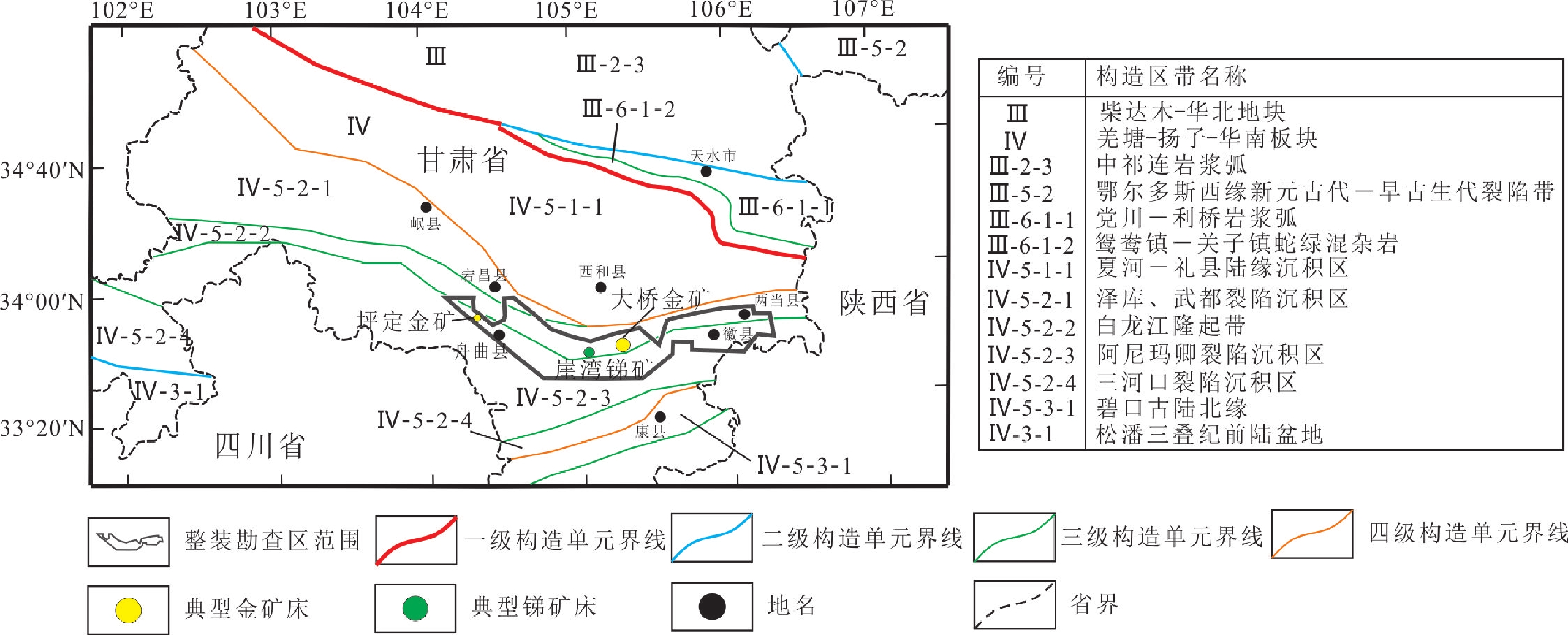
李永胜,中国地质调查局发展研究中心,自然资源部矿产勘查技术指导中心,负责矿产类数据集数据时间范围 2018—2019年 地理区域 西秦岭地区,E 104°00′~106°29′,N 33°30′~34°00′ 数据格式 *.wl,*.wt,*.wp,*.docx 数据量 1.2 GB 数据服务系统网址 http://dcc.cgs.gov.cn 基金项目 中国地质调查局地质调查子项目“甘肃崖湾—大桥地区金锑矿整装勘查区1∶50 000矿产资源潜力评价” (项目编号:0747-1861SITCN150-66) 语种 中文 数据库(集)组成 主要由整装勘查区综合建造构造图、成矿要素图、预测要素图、预测成果图、成矿规律图、勘查工作部署建议图(MapGIS格式)组成 表 2 异常下限计算表
元素 样品总数/个 剔除特高、特低值后(地球化学背景场) 异常下限 样品数/个 平均值(X) 离差(S) Cu 18209 16673 26.7818 8.8293 44.44 Pb 18209 17085 28.3936 7.4865 43.37 Zn 18209 16172 93.458 27.2119 147.9 Ag 18209 16570 91.7739 41.266 174.3 Mo 18209 16297 1.1399 0.5971 2.334 Sn 18209 17218 3.4372 0.9004 5.24 W 18209 17347 2.3939 1.0269 4.45 Mn 17615 16665 707.971 214.2623 1136.5 Ba 16971 16004 483.4528 132.9016 749.3 As 18209 16872 13.6425 8.3916 30.43 Sb 18209 16346 1.6418 1.1453 3.93 Bi 18209 16372 0.3295 0.0835 0.497 Cd 16282 14956 0.2516 0.1297 0.51 Au 18209 16534 1.2887 0.7736 2.836 Hg 18209 17537 108.8115 144.7213 398.3 注:Au、Ag、Hg含量单位为×10–9,其他均为×10–6。 表 3 甘肃崖湾—大桥金锑整装勘查区矿产预测类型划分表
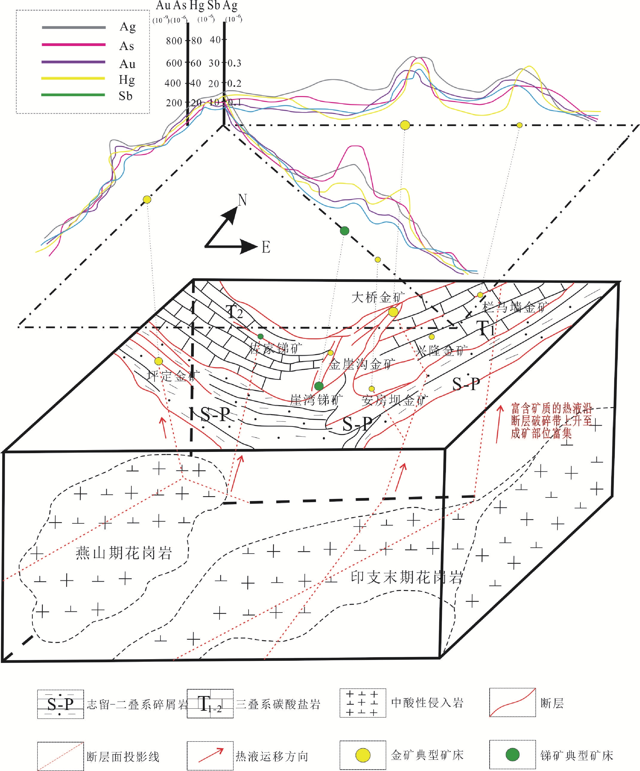
二级分类 三级分类 成因类型 预测类型 岩浆作用矿床 岩浆期后(中)低温热液型矿床 层控–热液型 大桥式层控–热液型金矿 构造–热液型 坪定式构造–热液型金矿 崖湾式构造–热液型锑矿 表 4 甘肃崖湾—大桥金锑整装勘查区成矿要素表
成矿要素 描述内容 分类 成矿地质背景 大地构造位置 北部为白龙江隆起带沉积区,南部为阿尼玛卿裂陷沉积区 重要 区域成矿带 北部为碌曲—徽县成矿亚带;南部为迭部—陇南成矿亚带 重要 岩浆岩带 北部为白龙江隆起带构造岩浆岩段,南部为阿尼玛卿裂陷沉积区构造岩浆岩段 重要 构造环境 秦岭东西构造带,武都弧型构造(舟曲—成县—徽县区域断裂、岷县—宕昌—两当区域断裂、窑上—石峡断裂) 重要 成矿时代 印支晚期(晚三叠纪) 必要 主攻矿种 金、锑 重要 成矿地质体 印支晚期中酸性侵入体(深部隐伏) 必要 脉体 中酸性岩脉、(黑云母)花岗闪长岩脉、长英岩脉和煌斑岩脉 次要 成矿构造及
成矿结构面层控–热液型金矿:成矿构造主要为NE向区域性构造及其发育的次级断裂、裂隙构造,呈不规则线状披覆于石炭系基底灰岩上的滑脱断层,总体呈NE—SW走向基底高角度断层。成矿结构面为细碎屑岩建造和碳酸盐岩建造之间的大型硅钙界面 必要 构造–热液型锑矿:成矿构造主要为一套NEE—SWW的走向断层以及NE—SW向次级平行小断裂。成矿结构面是此类型成矿构造的次生构造成因成矿结构面 构造–热液型金矿:成矿构造主要为一套与NW向区域构造大致平行的层间挤压断裂破碎带、构造裂隙。成矿结构面是此类型成矿构造的次生构造成因成矿结构面 成矿作用特征标志 矿床(点) 13个岩浆期后(中)低温热液型金矿床(点),8个锑矿床(点) 必要 蚀变类型 层控–热液型金矿:硅化、碳酸盐化、绢云母化、萤石化、黄铁矿化、褐铁矿化等,其中硅化与金矿化关系密切 重要 构造–热液型金矿:硅化、碳酸盐化(脉状方解石)、迪开石化、滑石化及星点状黄铁矿化、臭葱石化、雄雌黄矿化等,其次还有绿泥石化、叶蜡石化、萤石化及绢云母化等 构造–热液型锑矿:硅化、方解石化、黄铁矿化和萤石化及少量的褐铁矿化、绢云母化、高岭土化。其中硅化与锑矿化关系密切 风化特征 构造–热液型金矿:褐铁矿化 次要 构造–热液型锑矿:锑锗石化、褐铁矿化、高岭土化、黄锑华化 矿物组合 层控–热液型金矿:金属矿物主要以黄铁矿、褐铁矿、白铁矿等为主,其次有毒砂、黄铜矿、闪锌矿、方铅矿等;脉石矿物主要有石英,少量方解石、白云石、长石、绢云母、绿泥石、高岭土、萤石、磷灰石、锆石等 重要 构造–热液型金矿床:矿石矿物主要为黄铁矿、雌黄和雄黄,其次为毒砂、白铁矿、褐铁矿、汞砷黝铜矿、自然砷、自然硫、辉锑矿、锑汞矿、方铅矿、辰砂、闪锌矿、银黝铜矿、臭葱石、特硫锑铅矿等;脉石矿物主要有石英、迪开石、高岭石、白云母、绢云母、方解石、白云石等 构造–热液型锑矿床:金属矿物主要为辉锑矿、黄铁矿、白铁矿、锑锗石、黄锑华;非金属矿物主要有石英、方解石、萤石、绢云母、高岭土等 表 5 甘肃崖湾—大桥金锑整装勘查区区域预测要素表
成矿要素 描述内容 分类 成矿地质背景 大地构造位置 北部为白龙江隆起带沉积区,南部为阿尼玛卿裂陷沉积区 重要 区域成矿带 北部为碌曲—徽县成矿亚带;南部为迭部—陇南成矿亚带 重要 岩浆岩带 北部为白龙江隆起带构造岩浆岩段,南部为阿尼玛卿裂陷沉积区构造岩浆岩段 重要 构造环境 秦岭东西构造带,武都弧型构造(舟曲—成县—徽县区域断裂、岷县—宕昌—两当区域断裂、窑上—石峡断裂) 重要 成矿时代 印支晚期(晚三叠世) 必要 主攻矿种 金、锑 重要 成矿地质体 印支晚期中酸性侵入体(深部隐伏岩体) 必要 脉体 中酸性岩脉、(黑云母)花岗闪长岩脉、长英岩脉和煌斑岩脉 次要 成矿构造及
成矿结构面层控–热液型金矿:成矿构造主要为北东向区域性构造及其发育的次级断裂、裂隙构造,呈不规则线状披覆于石炭系基底灰岩上的滑脱断层,总体呈北东—南西走向基底高角度断层。成矿结构面为细碎屑岩建造和碳酸盐岩建造之间的大型硅钙界面
构造–热液型锑矿:成矿构造主要为一套NEE—SWW向的断层以及NE—SW向次级平行小断裂。成矿结构面是此类型成矿构造的次生构造成因成矿结构面
构造–热液型金矿:成矿构造主要为一套与NW向区域构造大致平行的层间挤压断裂破碎带、构造裂隙。成矿结构面是此类型成矿构造的次生构造成因成矿结构面必要 成矿作用特征标志 矿床(点) 13个岩浆期后(中)低温热液型金矿床(点),8个锑矿床(点) 必要 蚀变类型 层控–热液型金矿:硅化、碳酸盐化、绢云母化、萤石化、黄铁矿化、褐铁矿化等
构造–热液型金矿:硅化、碳酸盐化(脉状方解石)、迪开石化、滑石化及星点状黄铁矿化、臭葱石化、雄雌黄矿化等
构造–热液型锑矿:硅化、方解石化、黄铁矿化和萤石化等。其中硅化与金、锑矿化关系密切重要 风化特征 构造–热液型金矿:褐铁矿化
构造–热液型锑矿:锑锗石化、褐铁矿化、高岭土化、黄锑华化次要 矿物组合 层控–热液型金矿:金属矿物主要以黄铁矿、褐铁矿、白铁矿等为主
构造–热液型金矿床:矿石矿物主要为黄铁矿、雌黄和雄黄
构造–热液型锑矿床:金属矿物主要为辉锑矿、黄铁矿、白铁矿、锑锗石、黄锑华重要 物探 重力 利用重力资料推断解释出19条断裂构造,其中一级断裂1条,三级断裂18条,是间接找矿的重要要素 重要 圈定侵入岩体6处(基性–超基性岩体1处,酸性–中酸性岩岩体5处),其中酸性–中酸性岩体与金锑成矿有关 重要 推断中—新生代沉积盆地5处 次要 航磁 利用磁测资料推断解释出19条断裂构造,其中一级断裂1条,三级断裂18条,是间接找矿的重要要素 重要 圈定侵入岩体6处(基性–超基性岩1处、酸性–中酸性岩5处),其中酸性–中酸性岩体与金锑成矿有关 重要 推断变质岩地层1处 次要 依据磁异常特征及地质背景,筛选出磁异常24处,其中甲类异常7处、乙类异常5处、丙类异常1处,丁类异常11处 次要 化探 地球化学异常 Au、As、Hg、Sb、Cu、Pb、Zn、Ag、Cd、W、Bi、Mo、Sn13种元素综合异常,Au、As、Hg、Sb 单元素异常 必要 化探推断 利用化探资料推断出2处岩体 重要 剥蚀程度 通过WMoBi衬值积与HgAsSb衬值积做比值,分析出全区剥蚀程度:层控–热液型金矿床:比值变化范围为1.1698~12.9192,属中等剥蚀程度
构造–热液型金矿床:比值变化范围为0.0535~3.0801,属弱剥蚀程度
构造–热液型锑矿床:比值变化范围为0.0535~3.0801,属弱剥蚀程度
剥蚀程度影响矿体是否被剥蚀重要 遥感 线要素 NWW–EW–NEE向区域性断裂以及NE向和SN向次级断层,控制着工作区的构造格局,亦作为控岩控矿构造,与热液型矿床成因有密切关系 必要 环要素 17处环形构造以单环形态为主,另有半环、同心环和相切环,多与隐伏岩体有关,部分与构造作用有关,与成矿关系不明 次要 带要素 区内6组带状要素由灰岩、粉砂质板岩、硅质岩、砂岩等岩石组成,在区域上与成矿关系密切,具有较明确的示矿意义 重要 遥感异常 铁染、铝羟基、镁羟基、碳酸盐、硅化等遥感异常强度较大、较集中,套合性、成带性较好,硅化、碳酸盐化异常零星分布在葱地东、两河口、铁夹山等一带,多处于三叠系河湖相碎屑岩、泥盆系浅海相碎屑岩等地层、岩层接触地带及区域性断裂影响部位。羟基、碳酸盐化等异常分布区域与已知矿点、矿化带或矿化蚀变有较好的对应或套合关系,遥感找矿预测标志较好 重要 Table 1. Metadata Table of Database (Dataset)
Item Description Database (dataset) name Dataset of 1∶50 000 Mineral Resource Potential Assessment of Gold–Antimony Deposit Integrated Exploration Area in Yawan–Daqiao Area, Gansu Province Database (dataset) authors Zhang Jiarui, Gansu Institute of Geological Survey, responsible for the organization and implementation of the project and the establishment of the Dataset
Su Hu, Gansu Institute of Geological Survey, responsible for the development of the development of remote sensing dataset
Yu Xianglong, Gansu Institute of Geological Survey, responsible for the development of geological dataset
Gao Yongwei, Gansu Institute of Geological Survey, responsible for the development of mineral dataset
Jiang Wen, Gansu Institute of Geological Survey, responsible for the development of geophysical dataset
Liu Yuanping, Gansu Institute of Geological Survey, responsible for the development of geochemical dataset
Li Zeng, Gansu Institute of Geological Survey, responsible for the development of geological dataset
Li Yongsheng, Development and Research Center of China Geological Survey (i.e., Technical Guidance Center for Mineral Resources of Ministry of Natural Resources), responsible for the development of mineral datasetData acquisition time 2018–2019 Geographical area West Qinling area, 104°00′–106°29′E, 33°30′–34°00′N Data format *.wl, *.wt, *.wp, *.docx Data size 1.2 GB Data service system URL http://dcc.cgs.gov.cn Fund project The geological survey subproject entitled 1∶50 000Mineral Resource Potential Assessment of Gold-Antimony Deposit Integrated Exploration Area in Yawan–Daqiao Area, Gansu Province (No.: 0747-1861SITCN150-66) Language Chinese Database (dataset) composition The Dataset mainly consists of comprehensive suite-structure maps, metallogenic factor maps, predicative factor maps, prediction result maps, metallogenic regularity maps, and exploration deployment suggestion maps in MapGIS format. Table 2. Calculation results of anomaly thresholds
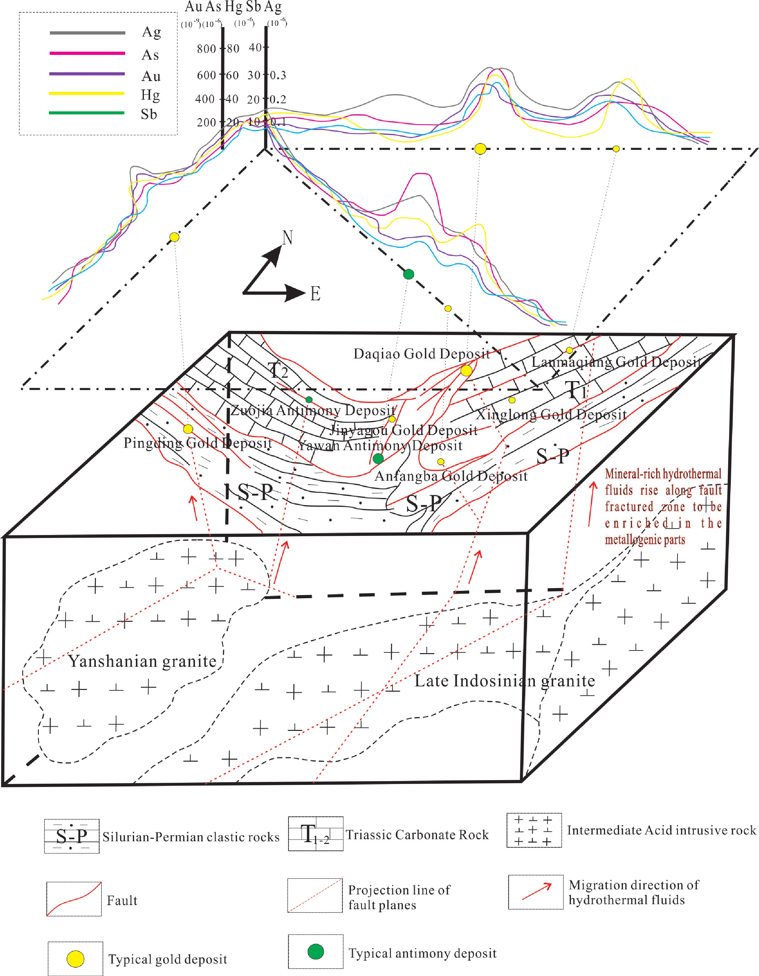
Element Sample quantity After removing extra-high and extra-low values (geochemical background field) Anomaly threshold Sample quantity Mean (X) Deviation (S) Cu 18 209 16 673 26.7818 8.8293 44.44 Pb 18 209 17 085 28.3936 7.4865 43.37 Zn 18 209 16 172 93.458 27.2119 147.9 Ag 18 209 16 570 91.7739 41.266 174.3 Mo 18 209 16 297 1.1399 0.5971 2.334 Sn 18 209 17 218 3.4372 0.9004 5.24 W 18 209 17 347 2.3939 1.0269 4.45 Mn 17 615 16 665 707.971 214.2623 1 136.5 Ba 16 971 16 004 483.4528 132.9016 749.3 As 18 209 16 872 13.6425 8.3916 30.43 Sb 18 209 16 346 1.6418 1.1453 3.93 Bi 18 209 16 372 0.3295 0.0835 0.497 Cd 16 282 14 956 0.2516 0.1297 0.51 Au 18 209 16 534 1.2887 0.7736 2.836 Hg 18 209 17 537 108.8115 144.7213 398.3 Note: The dimension is 10−9 for Au, Ag, and Hg and 10−6 for other elements. Table 3. Classification of mineral types to be predicted in Yawan–Daqiao gold-antimony deposit integrated exploration area in Gansu Province
Second-level classification Third-level classification Genetic type Mineral type to be predicted Magmatic deposits Postmagmatic (medium-) low-temperature hydrothermal deposits Stratabound−hydrothermal type Daqiao-type stratabound−
hydrothermal gold depositStructural−hydrothermal type Pingding-type structural−
hydrothermal gold depositYawan-type structural−
hydrothermal antimony depositTable 4. Metallogenic factors of the Yawan−Daqiao gold-antimony deposit integrated exploration area in Gansu Province
Metallogenic factor Description Type Metallogenic geological setting Geotectonic location The northern part is the sedimentary area of Bailongjiang uplift belt and the southern part is the sedimentary area of Anemaqen rift. Major Regional metallogenic belt The northern part is the Luqu−Huixian metallogenic subzone, and the southern part is the Diebu−Longnan metallogenic subzone. Major Magmatic rock belt The northern part is the tectono-magmatic rock section of the Bailongjiang uplift belt, and the southern part is the tectono-magmatic rock section of the sedimentary area of Anemaqen rift. Major Tectonic environment EW-trending Qinling tectonic belt, and Wudu arc-shaped structure (Zhouqu−Chengxian−Huixian regional fault, Minxian−Tanchang−Liangdang regional fault, and Yaoshang−Shixia fault) Major Metallogenic epoch Late Indosinian (Late Triassic) Necessary Major prospecting mineral types Gold, antimony Major Metallogenic geologic blocks Late Indosinian intermediate-acid intrusive bodies (deep concealed rock bodies) Necessary Vein bodies Intermediate-acid dikes, (biotite) granodiorite dikes, quartzofeldspathic dikes, and lamprophyre dikes Minor Metallogenic structures and metallogenic structural planes For stratabound−hydrothermal gold deposits, the metallogenic structures mainly include a NE-trending regional structure and its secondary faults and fissure structures. They are detachment faults irregularly covering the basement consisting of Carboniferous limestone, and serve as basement fault in NE-SW strike with a high dip angle in general. The metallogenic structural plane of the deposits is a large siliceous−calcareous interface between a fine-grained clastic rock suite and a carbonate rock suite. Necessary For structural-hydrothermal antimony deposits, the metallogenic structures mainly include a set of NEE-SWW-trending faults and NE-SW-trending secondary parallel minor faults. The metallogenic structural plane is formed from the secondary structures of the metallogenic structures. For structural-hydrothermal gold deposits, the metallogenic structures mainly include a set of interlayer compressive fractured zones and structural fissures that are roughly parallel to the NW-trending regional structure. The metallogenic structural plane is formed from the secondary structures of the metallogenic structures. Characteristics and indicators of metallogenesis Mineral deposit (ore occurrence) Thirteen postmagmatic (medium-) low-temperature hydrothermal gold deposits (ore occurrences), and eight antimony deposits (ore occurrences) Necessary Alteration types For stratabound−hydrothermal gold deposits: silicification, carbonation, sericitization, fluoritization, pyritization, and ferritization; among them, the silicification is closely related to gold mineralization. Major For structural−hydrothermal gold deposits: silicification, carbonation (veined calcite), dickitization, talcization, spotted pyritization, scoroditization, and mineralization of realgar and orpiment, followed by chloritization, pyrophyllization, fluoritization, and sericitization. For structural-hydrothermal antimony deposits: silicification, calcitization, pyritization, fluoritization, and a small amount of limonitization, sericitization, and kaolinization. Among them, silicification is closely related to antimony mineralization. Weathering characteristics For structural-hydrothermal gold deposits: limonitization. Minor For structural-hydrothermal antimony deposits: antimony-bearing germanitization, limonitization, kaolinization, and cervanitization. Mineral assemblages For stratabound-hydrothermal gold deposits: the metal minerals are dominated by pyrite, limonite, and marcasite, followed by arsenopyrite, chalcopyrite, sphalerite, and galena; gangue minerals mainly include quartz and a small amount of calcite, dolomite, feldspar, sericite, chlorite, kaolin, fluorite, apatite, and zircon. Major For structural-hydrothermal gold deposits: the ore minerals mainly include pyrite, orpiment, and realgar, followed by arsenopyrite, marcasite, limonite, mercury-bearing tennantite, native arsenic, native sulfur, antimonite, ammislite, galena, cinnabar, sphalerite, freibergite, scorodite, and special embritite; gangue minerals mainly include quartz, dickite, kaolinite, muscovite, sericite, calcite, and dolomite. For structural-hydrothermal antimony deposits: the metal minerals mainly include antimonite, pyrite, marcasite, antimony-bearing germanite, and cervanite; non-metal minerals mainly include quartz, calcite, fluorite, sericite, and kaolin. Table 5. Regional predictive factors of the Yawan–Daqiao gold-antimony deposit integrated exploration area in Gansu Province
Metallogenic factor Description Type Geological setting of metallogenesis Geotectonic position The northern part is the sedimentary area of Bailongjiang uplift belt and the southern part is the sedimentary area of Anemaqen rift. Major Regional metallogenic belt The north part is the Luqu−Huixian metallogenic subzone, and the southern part is the Diebu−Longnan metallogenic subzone. Major Magmatic rock belt The northern part is the tectono-magmatic rock section of the Bailongjiang uplift belt, and the southern part is the
tectono-magmatic rock section of the sedimentary area of Anemaqen rift.Major Tectonic environment EW-trending Qinling tectonic belt, and Wudu arc-shaped structure (Zhouqu−Chengxian−Huixian regional fault, Minxian−Tanchang−Liangdang regional fault, and Yaoshang−Shixia fault). Major Metallogenic epoch Late Indosinian (Late Triassic). Necessary Major prospecting mineral types Gold, antimony Major Metallogenic geologic blocks Late Indosinian intermediate-acid intrusive bodies (deep concealed rock bodies) Necessary Vein bodies Intermediate-acid dikes, (biotite) granodiorite dikes, quartzofeldspathic dikes, and lamprophyre dikes Necessary Metallogenic structures and metallogenic structural planes For stratabound−hydrothermal gold deposits, the metallogenic structures mainly include a NE-trending regional structure and its secondary faults and fissure structures. They are detachment faults irregularly covering the basement consisting of Carboniferous limestone, and serve as basement fault in NE-SW strike with a high dip angle in general. The metallogenic structural plane of the deposits is a large siliceous−calcareous interface between a fine-grained clastic rock suite and a carbonate rock suite.For structural-hydrothermal antimony deposits, the metallogenic structures mainly include a set of NEE-SWW-trending faults and NE-SW-trending secondary parallel minor faults. The metallogenic structural plane is formed from the secondary structures of the metallogenic structures.For structural-hydrothermal gold deposits, the metallogenic structures mainly include a set of interlayer compressive fractured zones and structural fissures that are roughly parallel to the NW-trending regional structure. The metallogenic structural plane is formed from the secondary structures of the metallogenic structures. Necessary Characteristics and indicators of metallogenesis Mineral deposits (ore occurrence) Thirteen postmagmatic (medium-) low-temperature hydrothermal gold deposits (ore occurrences), eight antimony deposits (ore occurrences) Necessary Alteration types For stratabound−hydrothermal gold deposits: silicification, carbonation, sericitization, fluoritization, pyritization, and ferritization.For structural−hydrothermal gold deposits: silicification, carbonation (veined calcite), dickitization, talcization, spotted pyritization, scoroditization, and mineralization of realgar and orpiment.For structural-hydrothermal antimony deposit: silicification, calcitization, pyritization, and fluoritization. Among them, silicification is closely related to mineralization of gold and antimony. Major Weathering characteristics For structural-hydrothermal gold deposits: limonitization.For structural-hydrothermal antimony deposits: antimony-bearing germanitization, limonitization, kaolinization, and cervanitization. Minor Mineral assemblages For stratabound-hydrothermal gold deposits: the metal minerals are dominated by pyrite, limonite, and marcasite.For structural-hydrothermal gold deposits: the ore minerals mainly include pyrite, orpiment, and realgar.For structural-hydrothermal antimony deposits: the metal minerals mainly include antimonite, pyrite, marcasite, antimony-bearing germanite, and cervanite. Major Geophysical exploration Gravity 19 fault structures were inferred from gravity data, including one first-order fault and 18 third-order faults. They are important factors for indirect prospecting. Major Six intrusive plutons (one basic-ultrabasic intrusions, and five acid − intermediate-acid intrusions) were delineated, of which the acid − intermediate-acid intrusions are related to the metallogenesis of gold and antimony. Major Five Mesozoic-Cenozoic sedimentary basins were inferred. Minor Aeromagnetic survey 19 fault structures were inferred from aeromagnetic data, including one first-order fault and 18 third- order faults. They are important factors for indirect prospecting. Major Six intrusive rocks (one basic-ultrabasic intrusions and five acid − intermediate-acid intrusions) were delineated, of which the acid − intermediate-acid intrusions are related to the metallogenesis of gold and antimony. Major One metamorphic rock stratum was inferred. Minor 24 magnetic anomalies were screened out according to the characteristics of magnetic anomalies and geological setting, including seven Class A, five Class B, one Class C, and 11 Class D anomalies. Minor Chemical exploration Geochemical anomalies Integrated anomalies of thirteen elements, i.e., Au, As, Hg, Sb, Cu, Pb, Zn, Ag, Cd, W, Bi, Mo, and Sn, and single element anomalies of As, Hg, and Au. Necessary Geochemical inference Two plutons were inferred from geochemical data. Major Denudation degree The denudation degree of the whole area was analyzed based on the ratio of the contrast value product of W-Mo-Bi to the contrast value product of Hg-As-Sb.For stratabound-hydrothermal gold deposits: the ratio varies from 1.1698 to 12.9192, indicating medium denudation.For structure-hydrothermal gold deposits: the ratio varies from 0.0535 to 3.0801, indicating weak denudation.For structure-hydrothermal antimony deposits: the ratio varies from 0.0535 to 3.0801, indicating weak denudation.The denudation degree affects the denudation of ore bodies. Major Remote sensing Line features NWW–EW–NEE-trending regional faults and their NE- and SN-trending secondary faults control the tectonic framework of the integrated exploration area. They also serve as rock-controlling and ore-controlling structures, and are closely related to the genesis of hydrothermal deposits. Necessary Circular features A total of 17 circular structures were delineated. They are mainly single circular in shape, followed by semicircular, concentric circular, and tangent circular structures. Most of them are related to concealed plutons, and some of them are related to tectonism. However, their relationship with mineralization remains unclear. Minor Zone features There are six sets of zone features composed of limestone, silty slate, siliceous rock, and sandstone in the area. They are closely related to regional mineralization, thus having clear significance for mineralization indication. Major Remote sensing anomalies The remote sensing anomalies of iron staining, hydroxy aluminum, hydroxy magnesium, carbonatation, and silicification are relatively strong and concentrated. They overlap each other and form definite zones. The anomalies of silicification and carbonation are sparsely distributed in Congdidong, Lianghekou, and Tiejiashan areas. Most of them occur in the contact zones of the strata and rock formations such as Triassic clastic rocks of fluviatile-lacustrine facies, Devonian clastic rocks of neritic facies and the parts affected by regional faults. The regional distribution of the anomalies of hydroxyl and carbonation well overlaps with or corresponds to the known ore occurrences, mineralized zones, or mineralized alteration. Therefore, these anomalies serve as good predictive indicators for remote sensing prospecting. Major -
[1] 杜远生. 1997. 秦岭造山带泥盆纪沉积地层学研究[M]. 武汉: 中国地质大学出版社. 53–56.
[2] 李清河, 郭建康, 周民都, 魏德晴, 范兵, 侯晓钰. 1991. 成县—西吉剖面地壳速度结构[J]. 西北地震学报, 13(S): 37−43. https://www.cnki.com.cn/Article/CJFDTOTAL-ZBDZ1991S1006.htm
[3] 叶天竺, 吕志成, 庞振山, 张德全, 刘士毅, 王全明, 刘家军, 程志中, 李超岭, 肖克炎, 甄世民, 杜泽忠, 陈正乐. 2014. 勘查区找矿预测理论与方法(总论)[M]. 北京: 地质出版社.
[4] 叶天竺, 韦昌山, 王玉往, 祝新友, 庞振山, 姚书振, 秦克章, 韩润生, 叶会寿, 孙景贵, 蔡煜琦, 甄世民, 薛建玲, 范宏瑞, 倪培, 曾庆栋, 蒋少涌, 杜杨松, 李胜荣, 郝立波, 张均, 陈正乐, 耿林, 潘家永, 蔡锦辉, 黄智龙, 李厚民, 孙丰月, 陈衍景, 陈郑辉, 杜泽忠, 陶文, 肖昌浩, 张志辉, 贾儒雅, 陈辉, 姚磊. 2017. 勘查区找矿预测理论与方法(各论)[M]. 北京: 地质出版社.
[5] 殷先明. 2009. 浅议弧形构造对西秦岭金矿的控制[J]. 甘肃地质, 18(4): 16−23. https://www.cnki.com.cn/Article/CJFDTOTAL-GSDZ200904004.htm
[6] 赵彦庆. 西秦岭金成矿系统分析[D]. 北京: 中国地质大学, 2004.
[7] 张翔, 戴霜, 刘建宏. 2017. 甘肃西秦岭金矿成矿与找矿研究[M]. 北京: 地质出版社.
[8] 张家瑞, 宿虎, 蒋文, 李永胜, 于晓飞. 2020. 甘肃崖湾—大桥地区金锑矿整装勘查区1∶50 000矿产资源潜力评价数据集[DB/OL]. 地质科学数据出版系统. (2020-12-30). DOI: 10.35080/data.C.2020.P33.
[9] 中国地质调查局发展研究中心. 2016. 《矿产资源潜力评价数据模型方法技术体系》[M]. 北京: 地质出版社.
[1] Development and Research Center of China Geological Survey. 2016. The Method and Technology System of Data Models for Mineral Resource Potential Assessment[M]. Beijing: Geological Publishing House (in Chinese).
[2] Du Yuansheng. 1997. Devonian Sedimentary Stratigraphy of Qinling orogenic belt[M]. Wuhan: China University of Geosciences Publishing House, 53–56(in Chinese).
[3] Li Qinghe, Guo Jiankang, Zhou Mindu, Wei Deqing, Fan Bing, Hou Xiaoyu. 1991. The velocity structure of Chengxian–Xiji profile[J]. Northwestern Seismological Journal, 13(supp.): 37−43 (in Chinese with English abstract).
[4] Ye Tianzhu, Lyu Zhicheng, Pang Zhenshan, Zhang Dehui, Liu Shiyi, Wang Quanming, Liu Jiajun, Cheng Zhizhong, Li Chaoling, Xiao Keyan, Zhen Shimin, Du Zezhong, Chen Zhengle. 2014. Theories and methods of prospecting prediction in prospecting areas (general)[M]. Beijing: Geological Publishing House (in Chinese).
[5] Ye Tianzhu, Wei Changshan, Wang Yuwang, Zhu Xinyou, Pang Zhenshan, Yao Shuzhen, Qin Kezhang, Han Runsheng, Ye Huishou, Sun Jinggui, Cai Yuqi, Zhen Shimin, Xue Jianling, Fan Hongrui, Ni Pei, Zeng Qingdong, Jiang Shaoyong, Du Yangsong, Li Shengrong, Hao Libo, Zhang Jun, Chen Zhengle, Geng Lin, Pan Jiayong, Cai Jinhui, Huang Zhilong, Li Houmin, Sun Fengyue, Chen Yanjing, Chen Zhenghui, Du Zezhong, Tao Wen, Xiao Changhao, Zhang Zhihui, Jia Ruya, Chen Hui, Yao Lei. 2017. Theories and methods of prospecting prediction in prospecting areas (monographs)[M]. Beijing: Geological Publishing House (in Chinese).
[6] Yin Xianming. 2009. Discussion on control of arcuate structures to gold deposits in western Qinling[J]. Gansu Geology, 18(4): 16−23 (in Chinese with English abstract).
[7] Zhang Jiarui, Su Hu, Jiang Wen, Li Yongsheng, Yu Xiaofei. 2020. Dataset of 1∶50 000 mineral resource potential assessment of gold-antimony deposit integrated exploration area in Yawan–Daqiao area, Gansu Province[DB/OL]. Geoscientific Data & Discovery Publishing System. (2020-12-30). DOI: 10.35080/data.C.2020.P33.
[8] Zhang Xiang, Dai Shuang, Liu Jianhong. 2017. Study on mineralization and prospecting of West Qinling gold deposit in Gansu Province[M]. Beijing: Geological Publishing House (in Chinese).
[9] Zhao Yanqing. 2004. Analysis of gold metallogenic system in West Qinling[D]. Beijing: China University of Geosciences (in Chinese).
-


 下载:
下载:


