The influence of major water conservancy projects on the geological environment of channel and shoreline in the middle and lower reaches of the Yangtze River
-
摘要:
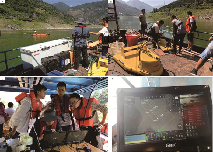
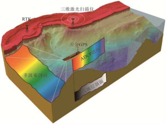
本文主要采取历史水下地形和水位数据分析、干流河槽现场测量、室内测试和综合评价等方法对重大水利工程影响长江中下游干流河槽和岸线进行了分析和研究,取得如下新进展:(1)创新构建了一套多模态传感器系统,实现陆上和水下一体化水动力、沉积和地貌特征测量与数据采集。(2)调查研究发现,长江干流河槽冲刷强烈,岸线窝崩、条崩发育。(3)悬沙和床沙粗化,河床阻力下降,发育侵蚀型链珠状沙波,长江大桥主桥墩冲刷严重。(4)潮区界显著上移,潮区界变动河段地貌发生重要变化。在此基础上,研究认为应该加强长江中下游干流河槽、沿岸高陡岸坡、支流入汇干流河口、崩岸以及跨江大桥桥墩冲刷等调查、监测和成因机理分析。上述研究成果对长江岸滩防护和修复、航道整治、沿岸防洪、长江大桥桥墩维护等具有重要意义。
Abstract:Based on the analysis of historical underwater topography and water level data, field measurement, laboratory test and comprehensive evaluation, the influence of major water conservancy projects on the channels and shorelines of the middle and lower reaches of the Yangtze River is studied. Some new progresses have been made. Firstly, a multi-mode sensor system was innovatively constructed to integrate the measurements of land and underwater hydrodynamic, sedimentary and geomorphic characteristics and data acquisition. Secondly, it was found that the main channel of the Yangtze River experienced strong erosion, arc collapse, and strip collapse. Thirdly, the hanging sand and bed sand were coarsened. The resistance of the river bed dropped, which caused the forming of the erosion type chain bead sand wave. The main piers of the Yangtze River Bridge were subjected to serious erosion. Finally, the tidal limit obviously moved up, and the geomorphology of the river changed significantly. On this basis, it is suggested that the investigation, monitoring and mechanism analysis should be strengthened on main river channel, high and steep slope along the bank, the estuary where the tributaries join the main stream, bank collapsing, cross-river bridge pier scour and so on. These results are of great significance to the protection and restoration of the bank and beach of the Yangtze River, the waterway regulation, the coastal flood control, and the maintenance of the piers of the Yangtze River Bridge.
-

-
Allen J R L. 1980. Sand waves: A model of origin and internal structure[J]. Sedimentary Geology, 26(4): 281-328. doi: 10.1016/0037-0738(80)90022-6
Barnard P L, Erikson L H, Kvitek R G. 2011. Small-scale sediment transport patterns and bedform morphodynamics: New insights from high-resolution multibeam bathymetry[J]. Geo-Marine Letters, 31(4): 227-236. doi: 10.1007/s00367-011-0227-1
Carriquiry J D, Sánchez A, Camacho-Ibar V F. 2001. Sedimentation in the northern Gulf of California after cessation of the Colorado River discharge[J]. Sedimentary Geology, 144(1/2): 37-62. http://www.onacademic.com/detail/journal_1000034153333910_d59d.html
Chen Min, Shen Huazhong, Feng Yuan, Sun Changcheng. 2017. Emergency management of river bank collapsing in the middle and lower reaches of Yangtze River in recent years[J]. Water Resources and Hydropower Express, 38(11): 15-19(in Chinese with English abstract).
Cheng Heqin, Jiang Yuehua. 2021. Physical Processes of River Channels in the Middle and Lower Reaches of the Yangtze River[M]. Beijing: Science Press(in Chinese).
Cheng Heqin, Li Maotian, Zhou Tianyu, Xue Yuanzhong. 2002. Modern microtopography and its movement characteristics of the Yangtze estuary[J]. Ocean Engineering, 20: 91-95(in Chinese with English abstract).
Chen Jiyu, Yun Caixing, Xu Haigen, Dong Yongfa. 1979. The developmental model of the Chang Jiang river estuary during last 2000 years[J]. Acta Oceanologica Sinica, (1): 103-111(in Chinese with English abstract). http://en.cnki.com.cn/Article_en/ http://search.cnki.net/down/default.aspx?filename=SEAC197901008&dbcode=CJFD&year=1979&dflag=pdfdown
Dai Shibao, Yang Shilun, Zhao Huayun, Li Ming. 2005. Response of middle and lower reaches of Yangtze river to the initial operation stage of the Three Gorges project[J]. Journal of Sediment Research, (5): 35-39(in Chinese with English abstract). http://en.cnki.com.cn/Article_en/CJFDTOTAL-NSYJ200505005.htm
Franzetti M, Le R P, Delacourt C, Garlan T, Cancouët R, Sukhovich A, Deschamps A. 2013. Giant dune morphologies and dynamics in a deep continental shelf environment: Example of the banc du four (Western Brittany, France)[J]. Marine Geology, 346: 17-30. doi: 10.1016/j.margeo.2013.07.014
Han Jianqiao, Sun Zhaohua, Huang Ying, Li Yitian. 2014. Features and causes of sediment deposition and erosion in Jingjiang reach after impoundment of the Three Gorges Project[J]. Journal of Water Conservancy, 45(3): 277-285(in Chinese with English abstract). http://en.cnki.com.cn/Article_en/CJFDTOTAL-SLXB201403004.htm
Han Qiwei, He Mingbing. 1979. Tendency of river channel evolution in Yangtze river's middle and lower reaches after Three Gorges project being completed[J]. Journal of Yangtze River Scientific Research Institute, 14(1): 62-66(in Chinese with English abstract). http://en.cnki.com.cn/Article_en/CJFDTOTAL-CJKB701.002.htm
Hou Chengcheng. 2013. Numerical Study on the Response of Tidal Current Limit and Tidal Limit as well as Saltwater Intrusion to Runoff Change in Yangtze River[D]. Shanghai: East China Normal University(in Chinese with English abstract).
Huang Sheng. 1986. The evolution characteristics of the Chang Jiang estuary[J]. Journal of Sediment Research, (4): 1-12(in Chinese with English abstract). http://en.cnki.com.cn/Article_en/CJFDTOTAL-NSYJ198604000.htm
Jiang Yuehua, Lin Liangjun, Chen Lide, Ni Huayong, Ge Weiya, Cheng Hangxin, Zhai Gangyi, Wang Guiling, Ban Yizhong, Li Yuan, Lei Mingtang, Tan Chengxuan, Su Jingwen, Zhou Quanping, Zhang Taili, Li Yun, Liu Hongying, Peng Ke, Wang Hanmei. 2017. Research on conditions of resources and environment and major geological problems in the Yangtze river economic zone[J]. Geology in China, 44(6): 1045-1061(in Chinese with English abstract). http://www.researchgate.net/publication/324013797_Research_on_conditions_of_resources_and_environment_and_major_geological_problems_in_the_Yangtze_River_Economic_Zone
Jiang Y H, Lin L J, Chen L D, Ni H Y, Ge W Y, Cheng H X, Zhai G Y, Wang G L, Ban Y Z, Li Y, Lei M T, Tan C X, Su J W, Zhou Q P, Zhang T L, Li Y, Liu H Y, Peng K, Wang H M. 2018. An overview of the resources and environment conditions and major geological problems in the Yangtze river economic zone, China[J]. China Geology, 1(3): 435-449. http://doc.paperpass.com/journal/20180050zgdz-e.html
Jiang Yuehua, Zhou Quanping, Chen Lide, Ni Huayong, Lei Mingtang, Cheng Hangxin, Shi Bin, Ma Teng, Ge Weiya, Su Jingwen, Li Yun, Tan Jianmin. 2019. Progresses and main achievements of geological environment comprehensive survey project in the Yangtze river economic zone[J]. Geological Survey of China, 6(5): 1-20 (in Chinese with English abstract). http://en.cnki.com.cn/Article_en/CJFDTotal-DZDC201905001.htm
Knaapen M A F. 2005. Sandwave migration predictor based on shape information[J]. Journal of Geophysical Research, 110(F4): 312-321. http://onlinelibrary.wiley.com/doi/10.1029/2004JF000195/pdf
Knaapen MAF, Hulscher SJMH, Vriend HJ, Stolk A. 2001. A new type of sea bed waves[J]. Geophysical Research Letters, 28(7): 1323-1326. doi: 10.1029/2000GL012007
Li H W, Cheng H Q, Li J F, Dong P. 2008. Temporal and spatial changes of dunes in the Changjiang (Yangtze) estuary, China[J]. Estuarine, Coastal and Shelf Science, 219(77): 169-174. http://www.onacademic.com/detail/journal_1000035040796610_9a62.html
Li Jia. 2004. The Tidal Limit and Tidal Current Limit of Yangtze Estuary and Its Response to Major Projects[D]. Shanghai: East China Normal University(in Chinese with English abstract).
Li Jianyong. 2007. Study on the Characteristics of Water Sand and Riverbed Evolution in the Datong-Xuliujing River Section of the Yangtze River[D]. Nanjing: Hohai University (in Chinese with English abstract).
Liu Hongxing, Wang Yongping. 2003. Basic model of bank slope deformation and instability in the middle and lower reaches of the Yangtze River[C]//Construction Administration Bureau of Important Embankment Concealment Works of the Yangtze River. Collection of Papers on Bank Revetment and Embankment Seep-proof Engineering of the Yangtze River. Beijing: China Water Conservancy and Hydropower Press: 78-82(in Chinese with English abstract).
Lu Xuejun, Cheng Heqin, Zhou Quanping, Jiang Yuehua, Guo Xingjie, Zheng Shuwei, Wu Suaihu. 2016. Features and mechanism of asymmetric double-kindneys scoured geomorphology of pier in tidal estuary[J]. Acta Oceanologica Sinica, 38(9): 118-125(in Chinese with English abstract). http://en.cnki.com.cn/Article_en/ http://search.cnki.net/down/default.aspx?filename=SEAC201609012&dbcode=CJFD&year=2016&dflag=pdfdown
Luo Xiangxin. 2006. Spatiotemporal Variations in Sediment Size in the Middle and Lower Reaches of the Yangtze River, Estuaries, and Adjacent Sea Areas: Natural Mechanisms and Effects of Human Activities[D]. Shanghai: East China Normal University (in Chinese with English abstract).
Luo X X, Yang S L, Wang R S, Zhang C Y, Li P. 2017. New evidence of Yangtze delta recession after closing of the Three Gorges Dam[J]. Scientific Reports, 7: 41735. doi: 10.1038/srep41735
Ma Xiaochuan. 2013. The Formation and Evolution of Seabed Sand Ridge in the Southwest Sea Area of Hainan Island and Its Engineering Significance[D]. Graduate School of Chinese Academy of Sciences (in Chinese with English abstract).
Naqshband S, Ribberink J S, Hurther D, Hulscher S J M H. 2014. Bed load and suspended load contributions to migrating sand dunes in equilibrium[J]. Journal of Geophysical Research Earth Surface, 119(5): 1043-1063. doi: 10.1002/2013JF003043
Osman A M, Thorne C R. 1988. Riverbank Stability Analysis I: Theory[J]. Journal of Hydraulic Engineering, 114(2): 134-150. doi: 10.1061/(ASCE)0733-9429(1988)114:2(134)
Qi Meilan. 2005. Riverbed scouring around bridge piers in river section with sand pits[J]. Journal of Water Conservancy, 36(7): 835-839(in Chinese with English abstract). http://www.researchgate.net/publication/291703965_Riverbed_scouring_around_bridge_piers_in_river_section_with_sand_pits
Rinaldi M. 2010. Recent channel adjustments in alluvial rivers of Tuscany, central Italy[J]. Earth Surface Processes & Landforms, 28(6): 587-608. http://www.onacademic.com/detail/journal_1000033837313110_d21d.html
Samoylov, Xie J Z (trans. ). 1958. The Theory and Method of the Evolution Processes of the Estuaries[M]. Beijing: Science Press, 81-91.
Shen Huanting, Zhu J R, Wu H L. 2008. The Pattern of Development of the Yangtze Estuary in the Past Two Thousand Years[M]. Beijing: Ocean Press: 40-54(in Chinese with English abstract).
Shi Shengyu, Cheng Heqin, Zheng Shuwei, Xu Wenxiao, Lu Xuejun, Jiang Yuehua, Zhou Quanping. 2017. Erosional topography of the tidal limit in the Yangtze river in flood seasons after the river closure at Three Gorges[J]. Acta Oceanologica Sinica, 39(3): 85-95 (in Chinese with English abstract). http://www.en.cnki.com.cn/Article_en/ http://search.cnki.net/down/default.aspx?filename=SEAC201703008&dbcode=CJFD&year=2017&dflag=pdfdown
Shi S Y, Cheng H Q, Xuan X N, Hu F X, Yuan X T, Jiang Y H, Zhou Q P. 2018. Fluctuations in the tidal limit of the Yangtze River estuary in the last decade[J]. Science China (Earth Sciences), 61(8): 832-841. http://www.scichina.org/doi/pdf/3c6619847f244cfeb980cbbebdf5bc9c
Surian N. 2002. Downstream variation in grain size along an Alpine river: Analysis of controls and processes[J]. Geomorphology, 43(1): 137-149. http://www.researchgate.net/profile/Nicola_Surian/publication/223157707_Downstream_variation_in_grain_size_along_an_Alpine_river_Analysis_of_controls_and_processes/links/0c96053803c3615485000000.pdf
Tang Jinwu, Deng Jinyun, You Xingying, Wang Fei. 2012. Forecast method for bank collapse in middle and lower Yangtze river[J]. Journal of Sichuan University (Engineering Science Edition), 44(1): 75-81(in Chinese with English abstract). http://en.cnki.com.cn/Article_en/CJFDTOTAL-SCLH201201013.htm
Thorne C R, Abt S R. 1993. Velocity and scour prediction in river bends[R]. Contract Report HL-93-1, US Army Engineer Waterways Experiment Station, Vicksburg, Mississippi, 39180: 66.
Van Landeghem K J J, Wheeler A J, Mitchell N C, Sutton G D. 2009. Variations in sediment wave dimensions across the tidally dominated Irish Sea, NW Europe[J]. Marine Geology, 263: 108-119. doi: 10.1016/j.margeo.2009.04.003
Wang Jian, Liu Ping, Gao Zhengrong, Bai Shibiao, Cao Guangjie, Qu Gguixian. 2007. Temporal-spatial Variation of the Channel in Jiangsu reach of the Yangtze river during the Last 44 Years[J]. Acta Geographica Sinica, 62(11): 1185-1193(in Chinese with English abstract). http://www.researchgate.net/publication/289163689_Temporal-spatial_variation_of_the_channel_in_Jiangsu_reach_of_the_Yangtze_River_during_the_last_44_years
Wang Jiayun, Dong Gguanglin. 1998. Analysis on damage and bank collapse of Yangtze river revetment project in Anhui Province[J]. Water Conservancy Construction and Management, 18(1): 62-64(in Chinese).
Wang Lujun. 2005. Large-scale Laboratory Experimental Study on the Mechanism of Bank Collapsing in the Middle and Lower Reaches of the Yangtze River[D]. Nanjing: Hehai University: 1-90(in Chinese with English abstract).
Wang Yong. 1999. Analysis on the cause and control measures of bank collapse in Anhui section of Yangtze river[J]. Yangtze River, 30(10): 19-20(in Chinese).
Wang Yuan, Li Dongtian. 2008. Exploration of distributed law of bank collapsing and plane eddy mechanism of arc collapsing along middle-lower Yangtze River[J]. Rock and Soil Mechanics, 29(4): 919-924(in Chinese with English abstract). http://www.cnki.com.cn/Article/CJFDTotal-YTLX200804015.htm
Wang Zhangqiao. 2006. Sediment Distribution and Before-Dam Study in Middle and Lower Yangtze River Stability[D]. Shanghai: East China Normal University (in Chinese with English abstract).
Wang Zhe, Chen Zhongyuan, Shi Yafeng, Li Maotian, Zhang Qiang, Wei Tiaoyuan. 2007. Pattern and dynamic mechanism of sand wave of bottom bed in the middle and lower reaches of Yangtze River (Wuhan-Estuary Section)[J]. Science China (series D): Earth Sciences, 37(9): 1223-1234 (in Chinese).
Williams G P, Wolman M G. 1984. Downstream effect of dams on alluvial rivers[J]. USGS Professional Paper 1286. http://htext.stanford.edu/dd-ill/downstream.pdf
Wu J X, Wang Y H, Cheng H Q. 2009. Bedforms and bed material transport pathways in the Changjiang (Yangtze) Estuary[J]. Geomorphology, 104(3-4): 175-184 doi: 10.1016/j.geomorph.2008.08.011
Wu Suaihu, Cheng Heqin, Li Jiufa, Mo Chuanyu. 2016. Recent processes of morphology and micro-topography in south passage of the Yangtze Estuary[J]. Journal of Sediment Research, 41(2): 47-53(in Chinese with English abstract). http://en.cnki.com.cn/Article_en/CJFDTOTAL-NSYJ201605009.htm
Wu Yuhua, Su Aijun, Cui Zhengquan, Xu Fuxing. 1997. Analysis on causes of bank collapse of Mahu dike in Pengze County, Jiangxi Province[J]. Yangtze River, 28(4): 27-30(in Chinese).
Wu Zhonghai, Zhou Chunjing, Huang Xiaolong, Zhao Genmo, Tan Chengxuan. 2020. Main active faults and seismic activity along the Yangtze River Economic Belt: Based on remote sensing geological survey[J]. China Geology, 3: 314-338. doi:10.31035/2020041.
Xu Hanxing, Fan Lianfa, Gu Mingjie. 2012. On tidal mark and tidal current mark in the Yangtze river[J]. Port & Waterway Engineering, 42(6): 15-20(in Chinese with English abstract) http://en.cnki.com.cn/Article_en/CJFDTOTAL-SYGC201206011.htm
Xu Quanxi, Zhu Lingling, Yuan Jing. 2013. Study on the erosion and deposition characteristics of water sand and riverbed in the middle and lower reaches of the Yangtze river[J]. The People of the Yangtze River, 44(23): 16-21(in Chinese). http://en.cnki.com.cn/Article_en/CJFDTOTAL-NSBD201303027.htm
Xu Xiaojun, Yang Sshilun, Zhang Zhen. 2010. Variation in grain size of sediment in middle and lower Chang Jiang river since impoundment of Three Gorges reservoir[J]. Scientia Geographica Sinica, 30(1): 103-107(in Chinese with English abstract). http://www.researchgate.net/profile/Shilun_Yang/publication/284580763_Variation_in_grain_size_of_sediment_in_middle_and_lower_Changjiang_River_since_impoundment_of_Three_Gorges_Reservoir/links/5684b42b08ae1e63f1f1d570.pdf
Xue Jiawei, Zhao Shuang. 2018. Construction of a legal system for joint prevention and control of illegal sand mining in the Yangtze River Basin[J]. Yangtze River Forum, 148(1): 66-73(in Chinese). http://en.cnki.com.cn/Article_en/CJFDTotal-CJJJ201803006.htm
Yang Yunping, Li Yitian, Han Jianqiao, Wang Dong. 2012. Variation of tide limit and tidal current limit in Yangtze estuary and its impact on projects[J]. Journal of Sediment Research, 37(6): 46-51(in Chinese with English abstract). http://en.cnki.com.cn/Article_en/CJFDTOTAL-NSYJ201206006.htm
Yangtze River Basin Planning Office. 1978. Experience of Bank Revetment in the Middle and Lower Reaches of Yangtze River[M]. Beijing: Science Press, 168(in Chinese with English abstract).
Youdeowei P O. 1997. Bank collapse and erosion at the upper reaches of the Ekole creek in the Niger delta area of Nigeria[J]. Bulletin of the International Association of Engineering Geology-Bulletin de l'Association Internationale de Géologie de l'Ingénieur, 55(1): 167-172.
Yu Wentao, Su Changcheng. 2007. Formation process and flow structure of "pocket type" arc collapsing in the middle and lower reaches of Yangtze river[J]. Yangtze River, 38(8): 156-159(in Chinese).
Zhang Xiaohe, Li Jiufa, Zhu Wenwu, Cheng Heqin, Chen Wei. 2015. Recent research on the evolution process and automatic adjustment mechanism of erosion and deposition in Yangtze river estuary[J]. Acta Oceanologica Sinica, 34(7): 123-130(in Chinese with English abstract). doi: 10.1007/s13131-015-0699-3
Zhang Zhen. 2011. Quantitative Estimation of the Influence of Three Gorges Project on Water Level and Water Sand Flux of the Yangtze river[D]. Shanghai: East China Normal University (in Chinese with English abstract).
Zheng S W, Cheng H Q, Shi S Y, Xu W, Zhou Q P, Jiang Y H, Zhou F N, Cao M X. 2018. Impact of anthropogenic drivers on subaqueous topographical change in the Datong to Xuliujing reach of the Yangtze River[J]. Science China (Earth Sciences), 61(7): 940-950. doi: 10.1007/s11430-017-9169-4
Zheng S W, Cheng H Q, Wu S H, Shi S Y, Xu W, Zhou Q P, Jiang Y H. 2017. Morphology and mechanism of the very large dunes in the tidal reach of the Yangtze River, China[J]. Continental Shelf Research, 139(1): 54-61. http://www.onacademic.com/detail/journal_1000039670250510_1e65.html
Zhuang Zhenyi, Cao Lihua, Liu Shengfa, Hu Guangyuan. 2008. Activity level and balance signs of subaqueous Dunes (Waves) in the Continental Shelf[J]. Periodical of Ocean University of China, 38(6): 1001-1007(in Chinese with English abstract).
长江流域规划办公室汇. 1978. 长江中下游护岸工程经验选编[M]. 科学出版社, 168.
陈吉余, 恽才兴, 徐海根, 董永发. 1979. 两千年来长江河口发育的模式[J]. 海洋学报, (1): 103-111. https://www.cnki.com.cn/Article/CJFDTOTAL-SEAC197901008.htm
陈敏, 沈华中, 冯源, 孙长城. 2017. 长江中下游河道近年崩岸应急整治[J]. 水利水电快报, 38(11): 15-19. https://www.cnki.com.cn/Article/CJFDTOTAL-SLSK201711003.htm
程和琴, 李茂田, 周天瑜, 薛元忠. 2002. 长江口现代微地貌及其运动特征[J]. 海洋工程, 20: 91-95.
程和琴, 姜月华. 2021. 长江中下游河槽物理过程[M]. 北京: 科学出版社.
戴仕宝, 杨世伦, 赵华云, 李明. 2005. 三峡水库蓄水运用初期长江中下游河道冲淤响应[J]. 泥沙研究, 5(5): 35-39. doi: 10.3321/j.issn:0468-155X.2005.05.006
韩剑桥, 孙昭华, 黄颖, 李义天. 2014. 三峡水库蓄水后荆江沙质河段冲淤分布特征及成因[J]. 水利学报, 45(3): 277-285. https://www.cnki.com.cn/Article/CJFDTOTAL-SLXB201403004.htm
韩其为, 何明民. 1997. 三峡水库建成后长江中下游河道演变的趋势[J]. 长江科学院院报, 14(1): 62-66. https://www.cnki.com.cn/Article/CJFDTOTAL-CJKB701.002.htm
侯成程. 2013. 长江潮流界和潮区界以及河口盐水入侵对径流变化响应的数值研究[D]. 上海: 华东师范大学: 1-118.
黄胜. 1986. 长江河口演变特征[J]. 泥沙研究, (4): 1-12. https://www.cnki.com.cn/Article/CJFDTOTAL-NSYJ198604000.htm
姜月华, 林良俊, 陈立德, 倪化勇, 葛伟亚, 成杭新, 翟刚毅, 王贵玲, 班宜忠, 李媛, 雷明堂, 谭成轩, 苏晶文, 周权平, 张泰丽, 李云, 刘红樱, 彭柯, 王寒梅. 2017. 长江经济带资源环境条件与重大地质问题[J]. 中国地质, 44(6): 1045-1061. http://geochina.cgs.gov.cn/geochina/ch/reader/view_abstract.aspx?file_no=20170601&flag=1
姜月华, 周权平, 陈立德, 倪化勇, 雷明堂, 程和琴, 施斌, 马腾, 葛伟亚, 苏晶文, 李云, 谭建民. 2019. 长江经济带地质环境综合调查工程进展与主要成果[J]. 中国地质调查, 6(5): 1-20. https://www.cnki.com.cn/Article/CJFDTOTAL-DZDC201905001.htm
李佳. 2004. 长江河口潮区界和潮流界及其对重大工程的响应[D]. 上海: 华东师范大学: 1-55.
李键庸. 2007. 长江大通-徐六泾河段水沙特征及河床演变研究[D]. 南京: 河海大学, 1-160.
刘红星, 王永平. 2003. 长江中下游干流河段岸坡变形失稳的基本模式[C]//长江重要堤防隐蔽工程建设管理局. 长江护岸及堤防防渗工程论文选集. 北京: 中国水利水电出版社, 78-82.
陆雪骏, 程和琴, 周权平, 姜月华, 郭兴杰, 郑树伟, 吴帅虎. 2016. 强潮流作用下桥墩不对称"双肾型"冲刷地貌特征与机理[J]. 海洋学报, 38(9): 118-125. doi: 10.3969/j.issn.0253-4193.2016.09.012
罗向欣. 2013. 长江中下游、河口及邻近海域底床沉积物粒径的时空变化: 自然机制和人类活动的影响[D]. 上海: 华东师范大学: 1-159.
马小川. 2013. 海南岛西南海域海底沙波沙脊形成演化及其工程意义[D]. 中国科学院研究生院(海洋研究所): 1-211.
齐梅兰. 2005. 采沙河床桥墩冲刷研究[J]. 水利学报, 36(7): 835-839. doi: 10.3321/j.issn:0559-9350.2005.07.012
萨莫依洛夫, 谢金赞译. 1958. 河口演变过程的理论及其研究方法. 北京: 科学出版社: 22-30.
沈焕庭, 朱建荣, 吴华林. 2008. 长江河口陆海相互作用界面[M]. 北京: 海洋出版社, 40-54.
石盛玉, 程和琴, 郑树伟, 徐文晓, 陆雪骏, 姜月华, 周权平. 2017. 三峡截流以来长江洪季潮区界变动河段冲刷地貌[J]. 海洋学报, 39(3): 85-95. doi: 10.3969/j.issn.0253-4193.2017.03.008
唐金武, 邓金运, 由星莹, 汪飞. 2012. 长江中下游河道崩岸预测方法[J]. 四川大学学报(工程科学版), 44(1): 75-81. https://www.cnki.com.cn/Article/CJFDTOTAL-SCLH201201013.htm
王家云, 董光林. 1998. 安徽省长江护岸工程损坏及崩岸原因分析[J]. 水利建设与管理, (1): 62-64. https://www.cnki.com.cn/Article/CJFDTOTAL-SLJS199801027.htm
王建, 刘平, 高正荣, 白世彪, 曹光杰, 屈贵贤. 2007. 长江干流江苏段44年来河道冲淤变化的时空特征[J]. 地理学报, 62(11): 1185-1193. https://www.cnki.com.cn/Article/CJFDTOTAL-DLXB200711010.htm
王路军. 2005. 长江中下游崩岸机理的大型室内试验研究[D]. 南京: 河海大学: 1-90.
王永. 1999. 长江安徽段崩岸原因及治理措施分析[J]. 人民长江, 30(10): 19-20. doi: 10.3969/j.issn.1001-4179.1999.10.008
王媛, 李冬田. 2008. 长江中下游崩岸分布规律及窝崩的平面旋涡形成机制[J]. 岩土力学, 29(4): 919-924. doi: 10.3969/j.issn.1000-7598.2008.04.013
王张峤. 2006. 三峡封坝前长江中下游河床沉积物分布及河床稳定性模拟研究[D]. 上海: 华东师范大学: 1-100.
王哲, 陈中原, 施雅风, 李茂田, 张强, 韦桃源. 2007. 长江中下游(武汉-河口段)底床沙波型态及其动力机制[J]. 中国科学D辑: 地球科学, 37(9): 1223-1234. https://www.cnki.com.cn/Article/CJFDTOTAL-JDXK200709010.htm
吴帅虎, 程和琴, 李九发, 莫传玉. 2016. 近期长江河口南槽冲淤变化与微地貌特征[J]. 泥沙研究, (2): 47-53. https://www.cnki.com.cn/Article/CJFDTOTAL-NSYJ201605009.htm
吴玉华, 苏爱军, 崔政权, 徐福兴. 1997. 江西省彭泽县马湖堤崩岸原因分析[J]. 人民长江, (4): 27-30. https://www.cnki.com.cn/Article/CJFDTOTAL-RIVE704.010.htm
许全喜, 朱玲玲, 袁晶. 2013. 长江中下游水沙与河床冲淤变化特性研究[J]. 人民长江, 44(23): 16-21. doi: 10.3969/j.issn.1001-4179.2013.23.004
徐汉兴, 樊连法, 顾明杰. 2012. 对长江潮区界与潮流界的研究[J]. 水运工程, (6): 15-20. doi: 10.3969/j.issn.1002-4972.2012.06.003
徐沛初, 刘开平. 1993. 长江的潮区界和潮流界[J]. 河流, (2): 24-29. https://cdmd.cnki.com.cn/Article/CDMD-10269-2004087559.htm
徐晓君, 杨世伦, 张珍. 2010. 三峡水库蓄水以来长江中下游干流河床沉积物粒度变化的初步研究[J]. 地理科学, 30(1): 103-107. https://www.cnki.com.cn/Article/CJFDTOTAL-DLKX201001015.htm
薛嘉伟, 赵爽. 2018. 长江流域非法采砂联防联控法律制度的构建[J]. 长江论坛, 148(1): 66-73. https://www.cnki.com.cn/Article/CJFDTOTAL-CJLT201801013.htm
杨云平, 李义天, 韩剑桥, 王冬. 2012. 长江口潮区和潮流界面变化及对工程响应[J]. 泥沙研究, (6): 46-51. doi: 10.3969/j.issn.0468-155X.2012.06.007
余文畴, 苏长城. 2007. 长江中下游"口袋型"崩窝形成过程及水流结构[J]. 人民长江, 38(8): 156-159. doi: 10.3969/j.issn.1001-4179.2007.08.058
张晓鹤, 李九发, 朱文武, 程和琴, 陈伟. 2015. 近期长江河口冲淤演变过程及自动调整机理研究[J]. 海洋学报, 34(7): 123-130. doi: 10.3969/j.issn.0253-4193.2015.07.012
张珍. 2011. 三峡工程对长江水位和水沙通量影响的定量估算[D]. 上海: 华东师范大学: 1-130.
庄振业, 曹立华, 刘升发, 胡广元. 2008. 陆架沙丘(波)活动量级和稳定性标志研究[J]. 中国海洋大学学报: 自然科学版, 38(6): 1001-1007. https://www.cnki.com.cn/Article/CJFDTOTAL-QDHY200806027.htm
-


 下载:
下载:
