

The application of a small airborne hyperspectral imaging spectrometer on remote sensing geology and lithology interpretation in alpine canyon regions
-
摘要:
研究目的 水利工程项目通常位于地势险峻的山区,交通不便、环境恶劣,勘察工作十分艰苦。同时,视界限制使地质人员不能整体上掌握地质体的面貌,尤其在高山峡谷地区,人力、物力及时间成本耗费巨大。高光谱遥感技术在地质领域中的应用主要集中在地物分布反演方向,通过未知地物与已知矿物之间相同的特征吸收峰来判定地物种类,利用其极高的光谱分辨率、空间分辨率和“图谱合一”的特性,可对高山峡谷区的地物目标进行精细分类,从而提高地质调查工作的效率,降低风险。
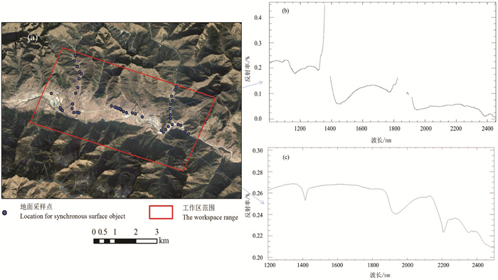
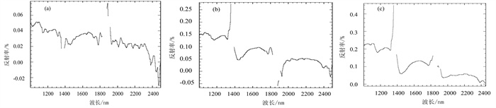
研究方法 中水北方勘测设计研究院利用中国地质调查局南京地质调查中心自主研发的高效率小型机载高光谱成像光谱仪,首次对位于甘南藏族自治州迭部县高山峡谷地带的工作区进行高光谱遥感对地探测,获取了工作区航空高光谱影像数据。采用最小噪声分离法、波段比值分析法对高光谱遥感数据进行岩性解译。
研究结果 结果表明:以白龙江为界,以北大部分为板岩及第四系黄土,以南则大部分为灰岩。解译结果与已知区域地质图岩性分布一致。
结论 本次研究验证了国产高光谱成像仪的可靠性与实用性,同时提高了水利工程前期地质勘查工作的效率和水平,并提供了险要地形地质勘察的一手资料。
Abstract:This paper is the result of geological survey engineering.
Objective Water conservancy projects are usually located in mountainous areas with steep terrain, inconvenient transportation and harsh environment, so that the survey work is very difficult. Meanwhile, the limitation of horizon makes it impossible for geologists to grasp the features of geological units as a whole, especially in high mountain and canyon areas. The application of hyperspectral remote sensing technology in the geological field mainly focuses on the extraction and identification of geological composition. The types of surface features are determined by similarity of spectral features between unknown geological units and known mineralsand rocks. Using its extremely high spectral resolution, spatial resolution and the advantage of union of imagery and spectrum, the technology can be applied on fine classification of rock types in alpine and canyon areas, so as to improve the efficiency of geological survey and reduce costs and risks.
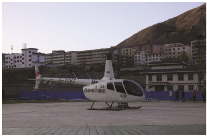
Methods This paper introduces Bei Fang Investigation, Design & Research Co., Ltd. adopting the SSMAP-II small short-wave infrared imaging system independently developed by the Nanjing Center, China Geological Survey in the project of "Research on Remote Sensing Geological Interpretation Methods Based on Hyperspectral Image Data", taking a helicopter as platform to carry out hyperspectral ground-based remote sensing surveys in Diebu County, Gannan Xizang Autonomous Prefecture. The surveys aerial hyperspectral image data of the study area, then used MNF minimum noise fraction(MNF) method and band ratio analysis method to interpret the lithology.
Results The interpretation result is basically consistent with the lithology distribution of the known regional geological map, providing first-hand information for the water conservancy projects of the dangerous areas.
Conclusions This research improves the work efficiency and the level of geological exploration, meanwhile it also verifies the reliability and practicability of the domestic hyperspectral imaging spectrometer.
-

-
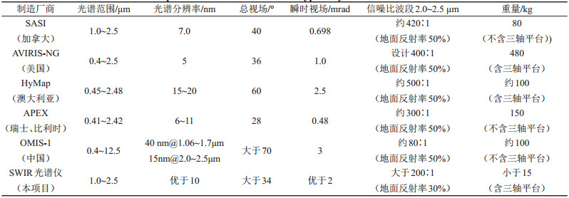
表 1 与国内外典型系统主要指标对比
Table 1. Comparison with main indexes of typical systems at home and abroad
 下载: 导出CSV
-
Bai Yu, Zheng Zhizhong, Xiu Liancun. 2022. UAV hyperspectral remote sensing technology and its application progress in natural resources survey[J]. East China Geology, 43(4): 527-538 (in Chinese with English abstract).
Berger B R, King T V V, Morath L C, Phillips J D. 2003. Utility of high-altitude infrared spectral data in mineral exploration: Application to northern Patagonia Mountains, Arizona[J]. Economic Geology, 98(5): 1003-1018. doi: 10.2113/gsecongeo.98.5.1003
Bierwirth P, Huston D, Blewett R. 2002. Hyperspectral mapping of mineral assemblages associated with gold mineralization in the central Pilbara[J]. Western Australia Economic Geology, 97: 819-826.
Campbell J B. 2010. Introduction to remote sensing[J]. Photogrammetric Record, 18(103): 259-259.
Dong Xinfeng, Gan Puping, Li Na, Yan Bokun, Zhang Lei, Zhao Jiaqi, Yu Junchuan, Liu Rongyuan, Ma Yanni. 2020. Fine mineral identification of GF-5 hyperspectral image[J]. Journal of Remote Sensing, 24(4): 454-464(in Chinese with English abstract).
Du Peijun, Bai Xuyu, Luo Jieqiong. 2018. Advances of urban remote sensing[J]. Journal of Nanjing University of Information Science & Technology, (1): 16-29 (in Chinese with English abstract).
Du Peijun, Xia Junshi, Xun Chaohui, Tan Kun, Su Hongjun, Bao Rui. 2016. Review of hyperspectral remote sensing image classification[J]. Journal of Remote Sensing, 20(2): 236-256(in Chinese with English abstract).
Gan Puping, Wang Runsheng. 2004. Study on Basic and Technical Methods of Extracting Information from Remote Sensing on Rocks[M]. Beijing: Geological Publishing House (in Chinese).
Govender M, Chetty K, Bulcock H. 2007. A review of hyperspectral remote sensing and its application in vegetation and water resource studies[J]. Water S A, 33(2): 145-151.
Jiang Tingxuan. 2018. Development and application of hyperspectral remote sensing technology in geology[J]. World Nonferrous Metals, 515(23): 254-255(in Chinese with English abstract). doi: 10.3969/j.issn.1002-5065.2018.23.146
Liu Kang, Zhou Zhuang, Li Shengyang, Liu Yunfei, Wan Xue, Liu Zhiwen, Tan Hong, Zhang Wanfeng. 2020. Scene classification dataset using the Tiangong-1 hyperspectral remote sensing imagery and its applications[J]. Journal of Remote Sensing, 24(9): 1077-1087 (in Chinese with English abstract).
Liu Yinnian. 2021. Development of hyperspectral imaging remote sensing technology[J]. Journal of Remote Sensing, 25(1): 439-459 (in Chinese with English abstract).
Ni Bin, Huang Zhaoqiang, Guo Jian. 2023. Identification of altered mineral information in the Wuyishanmetallogenic belt based on airborne and spaceborne hyperspectral remote sensing[J]. East China Geology, 44(1): 67-81 (in Chinese with English abstract).
Petrov D V, Zhuzhulina E A. 2021. Spectral dependence of Quasi-Rayleigh polarization leap of nonspherical particles: Polystyrene beads application[J]. Spectroscopy and Spectral Analysis, 41(2): 654-657.
Wang Denghong, Zhao Zhi, Yu Yang, Dai Jingjing, Deng Maochun, Zhao Ting, Liu Lijun. 2018. Exploration and research progress on ion-adsorption type REE deposit in South China[J]. China Geology, 1: 415-424.
Wang Runsheng, Gan Puping, Yan Bokun. 2010. Hyperspectral mineral mapping and its application[J]. Remote Sensing for Land & Resources, (1): 1-13 (in Chinese with English abstract).
Wang Runsheng, Xiong Shengqing, Nie Hongfeng. 2011. Remote sensing technology and its application in geological exploration[J]. Acta Geologica Sinica, 85(11): 1699-1743(in Chinese with English abstract).
Wei Guihua, Xiao Liang, Zheng Zhizhong. 2019. Auto-focusing method of push-broom hyperspectral camera[J]. Optics and Precision Engineering, 27(2): 185-192 (in Chinese with English abstract).
Wu Fuyu, Wang Xue, Ding Jianwei, Du Peijun, Tan Kun. 2020. Improved cascade forest deep learning model for hyperspectral imagery classification[J]. Journal of Remote Sensing, 24(4): 439-453 (in Chinese with English abstract).
Wu Zhonghai, Zhou Chunjing, Huang Xiaolong, Zhao Genmo, Tan Chengxuan. 2020. Main active faults and seismic activity along the Yangtze River Economic Belt: Based on remote sensing geological survey[J]. China Geology, 3: 314-338. doi: 10.31035/cg2020041
Xu Mingzuan, Liang Sen, Shi Jianlong. 2021. Airborne hyperspectral inversion of heavy metal distribution in cultivated soil: A case study of the Guanhe area, north Jiangsu Province[J]. East China Geology, 42(1): 100-107.
Zhang Da, Zheng Yuquan. 2013. Hyperspectral remote sensing and its development and application review[J]. Optics & Optoelectronic Technology, 11(3): 72-78 (in Chinese with English abstract).
Zhang Ka, Sheng Yehua, Zhang Shubi. 2004. Some progresses and applications of new technologies in remote sensing[J]. Remote Sensing Information, (2): 58-62 (in Chinese with English abstract).
Zhang Zhonggui, Wang Runsheng. 2000. Imaging spectrometer remote sensing methodological technology and its application based on spectroscopy[J]. Remote Sensing Forland & Resources, 12(3): 16-37 (in Chinese with English abstract).
Zheng Zhizhong, Yang Zhong, Qin Yuantian, Wang Liguo. 2020a. Structure analysis and experiment of an offner-type short-wave infrared imaging spectrometer[J]. Laser & Optoelectronics Progress, 57(5): 246-255 (in Chinese with English abstract).
Zheng Zhizhong, Yang Zhong, Xiu Liancun. 2020b. A lock-in amplifier applied to the measurement of weak spectral signals[J]. Modern Scientific Instruments, (2): 5-10(in Chinese with English abstract).
Zheng Zhizhong, Yang Zhong, Xiu Liancun. 2020c. Development and application of shortwave infrared convex blazed grating with high diffraction efficiency[J]. Acta Optica Sinica, 40(12): 1205002 (in Chinese with English abstract). doi: 10.3788/AOS202040.1205002
Zheng Zhizhong, Yang Zhong, XiuLiancun, Dong Jinxin, Chen Chunxia, Gao Yang. 2017. Design of a SWIR offner imaging spectrometer[J]. Spectroscopy and Spectral Analysis, 37(7): 2267-2272 (in Chinese with English abstract).
白宇, 郑志忠, 修连存. 2022. 无人机高光谱遥感技术在自然资源调查中的应用进展[J]. 华东地质, 43(4): 527-538. https://www.cnki.com.cn/Article/CJFDTOTAL-HSDZ202204011.htm
董新丰, 甘甫平, 李娜, 闫柏琨, 张磊, 赵佳琪, 于峻川, 刘镕源, 马燕妮. 2020. 高分五号高光谱影像矿物精细识别[J]. 遥感学报, 24(4): 454-464. https://www.cnki.com.cn/Article/CJFDTOTAL-YGXB202004014.htm
杜培军, 白旭宇, 罗洁琼. 2018. 城市遥感研究进展[J]. 南京信息工程大学学报, (1): 16-29. https://www.cnki.com.cn/Article/CJFDTOTAL-NJXZ201801004.htm
杜培军, 夏俊士, 薛朝辉, 谭琨, 苏红军, 鲍蕊. 2016. 高光谱遥感影像分类研究进展[J]. 遥感学报, 20(2): 236-256. https://www.cnki.com.cn/Article/CJFDTOTAL-YGXB201602008.htm
甘甫平, 王润生. 2004. 遥感岩矿信息提取基础与技术方法研究[M]. 北京: 地质出版社.
姜廷轩. 2018. 高光谱遥感技术在地质领域的发展与应用概况[J]. 世界有色金属, 515(23): 254-255. https://www.cnki.com.cn/Article/CJFDTOTAL-COLO201823146.htm
刘康, 周壮, 李盛阳, 刘云飞, 万雪, 刘志文, 谭洪, 张万峰. 2020. 天宫一号高光谱遥感场景分类数据集及应用[J]. 遥感学报, 24(9): 1077-1087. https://www.cnki.com.cn/Article/CJFDTOTAL-YGXB202009003.htm
刘银年. 2021. 高光谱成像遥感载荷技术的现状与发展[J]. 遥感学报, 25(1): 439-459. https://www.cnki.com.cn/Article/CJFDTOTAL-YGXB202101029.htm
倪斌, 黄照强, 郭健. 2023. 基于机载和星载高光谱遥感的武夷山成矿带蚀变矿物信息识别研究[J]. 华东地质, 44(1): 67-81. https://www.cnki.com.cn/Article/CJFDTOTAL-HSDZ202301008.htm
王润生, 甘甫平, 闫柏琨. 2010. 高光谱矿物填图技术与应用研究[J]. 国土资源遥感, (1): 1-13. https://www.cnki.com.cn/Article/CJFDTOTAL-GTYG201001002.htm
王润生, 熊盛青, 聂洪峰. 2011. 遥感地质勘查技术与应用研究[J]. 地质学报, 85(11): 1699-1743. https://www.cnki.com.cn/Article/CJFDTOTAL-DZXE201111003.htm
魏桂华, 肖亮, 郑志忠. 2019. 推扫式高光谱相机自动调焦[J]. 光学精密工程, 27(2): 185-192. https://www.cnki.com.cn/Article/CJFDTOTAL-GXJM201902021.htm
武复宇, 王雪, 丁建伟, 杜培军, 谭琨. 2020. 高光谱遥感影像多级联森林深度网络分类算法[J]. 遥感学报, 24(4): 439-453. https://www.cnki.com.cn/Article/CJFDTOTAL-YGXB202004013.htm
徐明钻, 梁森, 石剑龙. 2021. 航空高光谱反演耕地土壤重金属分布特征——以苏北灌河地区为例[J]. 华东地质, 42(1): 100-107. https://www.cnki.com.cn/Article/CJFDTOTAL-HSDZ202101012.htm
张达, 郑玉权. 2013. 高光谱遥感的发展与应用[J]. 光学与光电技术, (3): 72-78. https://www.cnki.com.cn/Article/CJFDTOTAL-GXGD201303017.htm
张卡, 盛业华, 张书毕. 2004. 遥感新技术的若干进展及其应用[J]. 遥感信息, (2): 58-62. https://www.cnki.com.cn/Article/CJFDTOTAL-YGXX200402022.htm
张宗贵, 王润生. 2000. 基于谱学的成像光谱遥感技术发展与应用[J]. 国土资源遥感, 12(3): 16-37. https://www.cnki.com.cn/Article/CJFDTOTAL-GTYG200003002.htm
郑志忠, 杨忠, 秦远田, 王立国. 2020a. Offner型短波红外成像光谱仪的结构分析与实验[J]. 激光与光电子学进展, 57(5): 246-255. https://www.cnki.com.cn/Article/CJFDTOTAL-JGDJ202005030.htm
郑志忠, 杨忠, 修连存. 2020b. 一种应用于弱光谱信号测量的锁相放大器[J]. 现代科学仪器, (2): 5-10.
郑志忠, 杨忠, 修连存. 2020c. 高衍射效率短波红外凸面闪耀光栅的研制与应用[J]. 光学学报, 40(12): 1205002. https://www.cnki.com.cn/Article/CJFDTOTAL-GXXB202012007.htm
郑志忠, 杨忠, 修连存, 董金鑫, 陈春霞, 高扬, 俞正奎. 2017. 一种Offner型小型短波红外成像光谱仪[J]. 光谱学与光谱分析, 37(7): 2267-2272. https://www.cnki.com.cn/Article/CJFDTOTAL-GUAN201707054.htm
-


图(11)
表(2)
计量
- 文章访问数: 2350
- PDF下载数: 147
- 施引文献: 0