

Ecological vulnerability assessment of Oroqen Region in the Inner Mongolia based on SRP model
-
摘要:
研究目的 随着社会经济发展和城镇化率不断提高,当前人类赖以生存的生态环境不断遭受破坏,生态脆弱性日益严峻,生态脆弱性评价已成为了诸多专家学者研究的热点。鄂伦春地区从20世纪产业结构从狩猎业转变为农牧业以来,当地生态环境面临脆弱化的风险。本文通过对鄂伦春地区3期生态脆弱性评价,以期为当地生态环境保护和可持续发展提供科学依据。
研究方法 以内蒙古鄂伦春地区为研究区,基于SRP模型,选取生态恢复力、生态压力度和生态敏感性等3种类型14项指标,利用GIS空间主成分分析(SPCA)和地理探测器(GeoDetector)对鄂伦春地区2000、2010、2020年3期生态脆弱性空间分布、时空演变和驱动因子进行分析。
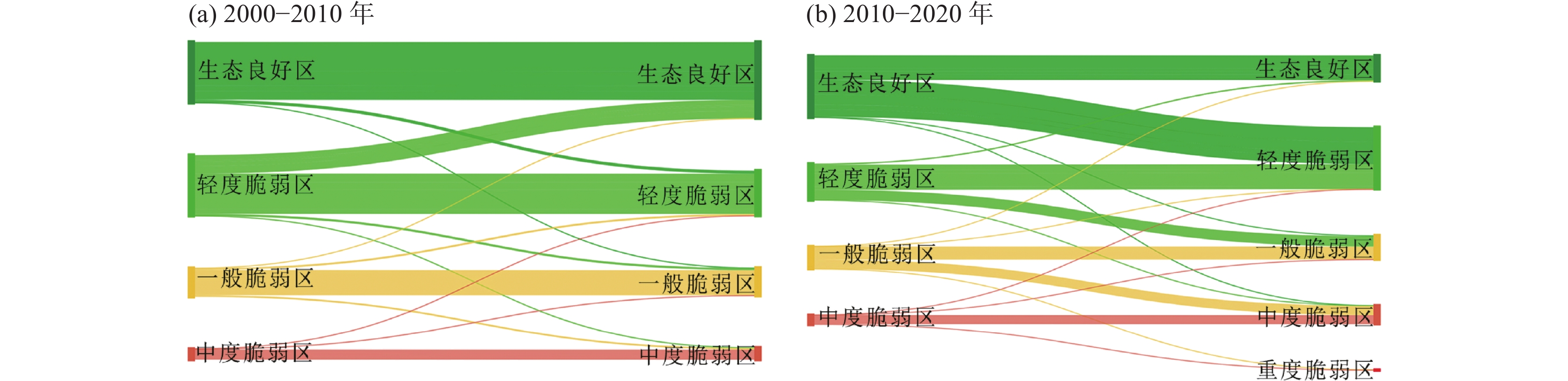
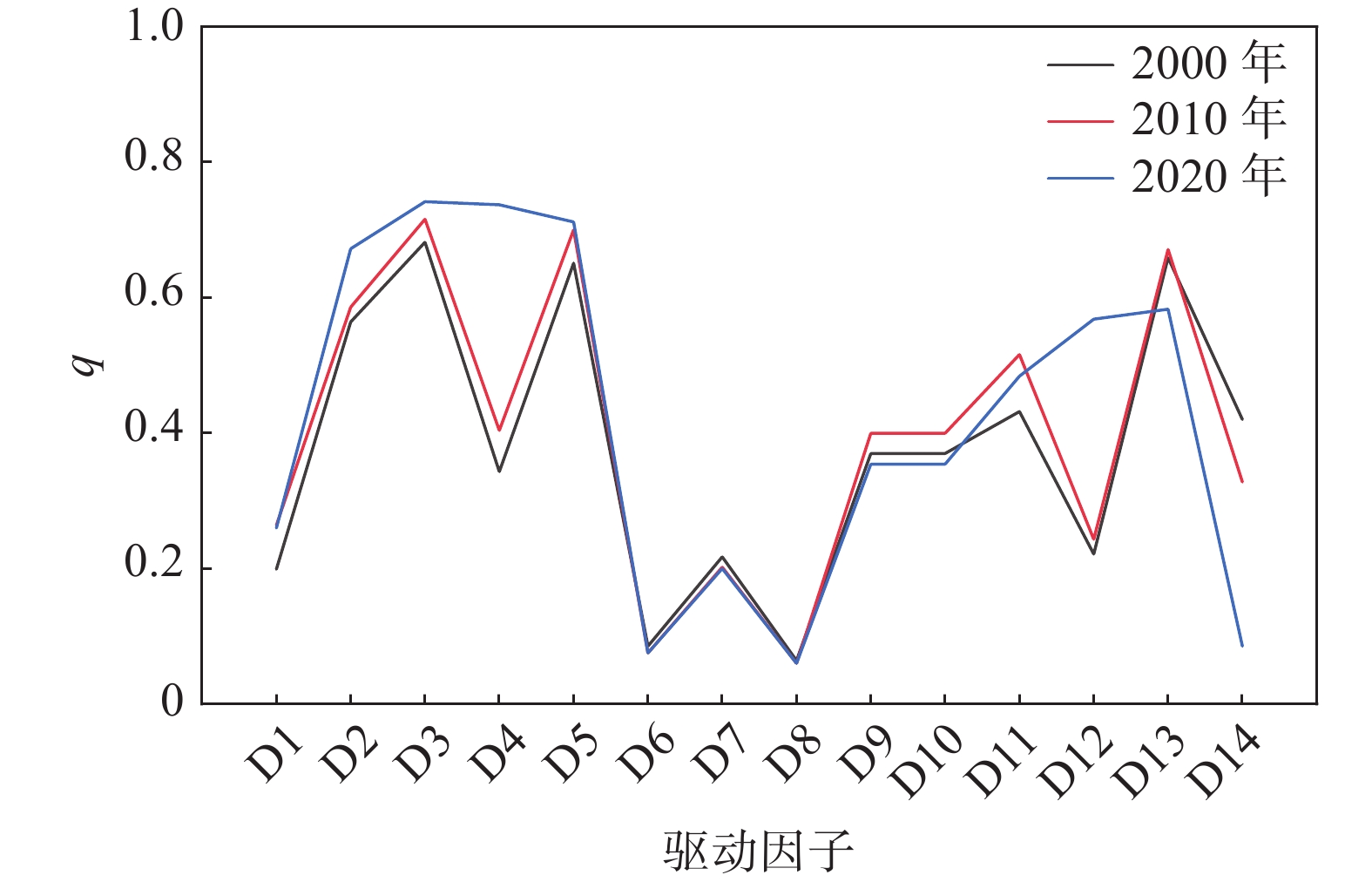
研究结果 (1)鄂伦春地区生态脆弱性整体为良好—轻度脆弱状态,一般性脆弱区在3年的分布面积大致相当,中度和重度脆弱区主要分布在阿里河镇南部、乌鲁布铁镇南部、大杨树镇和古里乡,生态环境总体呈现恶化趋势。(2)鄂伦春地区生态脆弱性在2000—2010年间生态环境呈向良好发展趋势,在2010—2020年间生态环境遭受较大破坏,生态脆弱性明显增加,2020年首次出现重度生态脆弱区面积达111.72 km2,占研究区面积的0.51%,生态环境形式严峻。(3)鄂伦春地区生态脆弱性空间分布主要受生物丰度(D2)、景观多样性指数(D3)、高程(D5)、人口密度(D13)等因素影响,在2020年影响因子呈现更加多元化,蔓延度指数(D4)和年均降水量(D12)两个指标对当地生态脆弱性有较强的驱动作用,q值分别为0.737和0.568。
结论 鄂伦春地区2000、2010、2020年3期生态脆弱性总体呈现西北部低、东南部高的显著特征,在2000—2010年间生态环境向良好发展,在2010—2020年间生态环境呈恶化趋势,鄂伦春地区生态脆弱性受人为活动和自然因素共同驱动导致。
Abstract:This paper is the result of environmental geological survey engineering.
Objective With the continuous increase in socio−economic development and the urbanization rate, the ecological environment that supports mankind’s survival has been damaged and ecological vulnerability has become more serious. Therefore, ecological vulnerability evaluation has become a hot research topic. Since the industrial structure of the Oroqen Region changed from hunting to farming and livestock in the 20th century, the local ecological environment has been threatened and is likely to be vulnerable to further threats. Consequently, in this paper, the ecological vulnerability of the Oroqen Region was evaluated in three phases to provide a scientific basis for environmental protection and sustainable development.
Methods The Oroqen Region in Inner Mongolia was selected as the study area, and 14 indicators were selected based on the SRP model, which were categorized into three types, namely ecological resilience, ecological sensitivity, and ecological stress. Then, Geographic Information System Spatial Principal Component Analysis (SPCA) and GeoDetector were used to analyze the spatial distribution, spatial and temporal evolution, and driving factors of ecological vulnerability in the Oroqen Region in 2000, 2010, and 2020.
Results (1) The overall ecological vulnerability of the Oroqen Region was a good-mild fragile state, the distribution area of the general fragile area remained stable for about three years, the moderately and severely fragile areas were mainly distributed in the south of Alihe, the south of Ulubuti, Dayangshu, and Guli, and there was an overall research deterioration trend. (2) The ecological vulnerability trend of the Oroqen Region was positive from 2000 to 2010, and the ecological vulnerability increased significantly from 2010 to 2020 when the ecological environment was damaged. Moreover, the area of severe ecological vulnerability that appeared for the first time in 2020 was 111.72 km2, accounting for 0.51% of the study area. (3) The spatial distribution of the ecological vulnerability in the Oroqen area was mainly influenced by the biological abundance (D2), landscape diversity index (D3), elevation (D5), population density (D13), and other factors, and the influencing factors were more diverse in 2020. Furthermore, the two indicators SRPeading index (D4) and average annual precipitation (D12) had a strong driving effect on the local ecological vulnerability.
Conclusions The ecological vulnerability of the Oroqen Region was low in the northwest and high in the southeast in 2000, 2010, and 2020, and the ecological environment became less vulnerable from 2000 to 2010 and deteriorated from 2010 to 2020. This was due to the continuous change in the natural conditions and the long−term influence of human activities. The ecological environment of the Oroqen Region is deteriorating in general.
-

-
表 1 土地利用类型和土壤类型赋值分级标准
Table 1. Grading standards for assignment of land use types and soil types
赋值标准 2 4 6 8 10 土地利用类型 林地、水域 草地 耕地 建设用地 裸地 土壤类型 暗棕壤 沼泽土 棕色针叶林土 草甸土 黑土  下载: 导出CSV
表 2 鄂伦春地区生态脆弱性分级标准
Table 2. Grading standards for ecological vulnerability in Oroqen Region
脆弱性分类 脆弱性等级 脆弱性分级标准 生态特征 生态良好区 Ⅰ <0.07 生态功能完善,抗外界能力和自我恢复能力强,生态脆弱性低 轻度脆弱区 Ⅱ 0.07~0.21 生态功能较完善,抗外界能力和自我恢复能力较强,生态脆弱性较低 一般脆弱区 Ⅲ 0.21~0.40 生态功能一般,抗外界能力和自我恢复能力较弱,生态脆弱性较高 中度脆弱区 Ⅳ 0.40~0.69 生态功能出现缺陷,抗外界能力和自我恢复能力弱,生态脆弱性高 重度脆弱区 Ⅴ >0.69 生态功能严重退化,抗外界能力和自我恢复能力差,生态脆弱性极高
下载: 导出CSV
表 3 各年度主成分分析结果
Table 3. Results of principal component analysis in each year
年份 主成分 PC1 PC2 PC3 PC4 PC5 2000 特征值 $ \lambda $ 0.103 0.046 0.021 0.014 0.012 贡献率 $ A $ /%45.148 20.082 9.162 6.297 5.431 累积贡献率/% 45.148 65.230 74.392 80.688 86.119 2010 特征值 $ \lambda $ 0.095 0.043 0.025 0.017 0.014 贡献率 $ A $ /%41.948 19.108 11.182 7.448 6.143 累积贡献率/% 41.948 61.056 72.238 79.686 85.829 2020 特征值 $ \lambda $ 0.115 0.050 0.033 0.023 0.017 贡献率 $ A $ /%43.046 18.758 12.253 8.527 6.464 累积贡献率/% 43.046 61.804 74.057 82.584 89.048
下载: 导出CSV
表 4 鄂伦春地区生态脆弱性空间分布驱动因子探测q值统计
Table 4. Detection q value statistics of spatial distribution driving factors of ecological vulnerability in Oroqen Region
驱动因子 q值 2000 2010 2020 归一化植被指数NDVI(D1) 0.199* 0.264* 0.260* 生物丰度(D2) 0.564* 0.586* 0.672* 景观多样性指数(D3) 0.682* 0.716* 0.742* 蔓延度指数(D4) 0.343* 0.404* 0.737* 高程(D5) 0.651* 0.700* 0.712* 坡度(D6) 0.085* 0.075* 0.075* 地形起伏度(D7) 0.217* 0.202* 0.200* 水土流失率(D8) 0.064* 0.060* 0.060* 土地利用类型(D9) 0.380* 0.410* 0.378* 土壤类型(D10) 0.370* 0.400* 0.354* 年均气温(D11) 0.432* 0.516* 0.484* 年均降水量(D12) 0.221* 0.243* 0.568* 人口密度(D13) 0.659* 0.671* 0.583* 人均GDP(D14) 0.420* 0.328* 0.085* 注:*表示通过0.05的显著性检验。
下载: 导出CSV
-
[1] Aishajiang Aili, Xu Hailiang, Yuan Kaiye. 2019. Assessment of the effects of artificial restoration measures in abandoned gold mining area in Altay Mountains using PCA and monitoring data[J]. Arid Land Geography, 42(2): 288−294 (in Chinese with English abstract).
[2] An Hongfeng, Xu Hao, An Ning, Wang Zhiming, Zuo Siyi. 2016. Comprehensive Evaluation of Eco−environmental Vulnerability in Karst Mountain Areas—Central Region of Guizhou Province as An Example[J]. Environmental Impact Assessment, 38(4): 51−56 (in Chinese with English abstract).
[3] Deng Hua, Shao Jing'an, Wang Jinliang, Gao Ming, Wei Chaofu. 2016. Land use driving forces and its future scenario simulation in the Three Gorges Reservoir Area using CLUE-S model[J]. Acta Geographica Sinica, 71(11): 1979−1997 (in Chinese with English abstract).
[4] Deng Wei, Yuan Xingzhong, Sun Rong, Zhang Yuewei. 2016. Eco-vulnerability Assessment Based on Remote Sensing in the argo-pastoral Ecotone of North China[J]. Environmental Science & Technology, 39(11): 174−181 (in Chinese with English abstract).
[5] Fu Boming. 1995. Landscape diversity analysis and mapping[J]. Acta Ecologica Sinica, (4): 345−350 (in Chinese with English abstract).
[6] Fu Gang, Bai Jiade, Qi Yue, Yan Bing, He Jing, Xiao Nengwen, Li Junsheng. 2018. Ecological vulnerability assessment in Beijing based on GIS spatial analysis[J]. Journal of Ecology and Rural Environment, 34(9): 830−839 (in Chinese with English abstract).
[7] Fu Yangjun, Shi Xueyi, He Juan. 2019. The spatio−temporal evolution characteristics of landscape fragmentation in Fenhe River Basin[J]. Journal of Natural Resources, 34(8): 1606−1619 (in Chinese with English abstract). doi: 10.31497/zrzyxb.20190804
[8] Guo Jing, Wei Zhen, Ren Jun, Zhou Huakun, Shi Yan. 2019. Analysis on ecological vulnerability in highcold and povertystricken mountainous areas based on entropy and gray correlation methods[J]. Bulletin of Soil and Water Conservation, 39(3): 191−199 (in Chinese with English abstract).
[9] Huang Fang, Liu Xiangna, Zhang Yangzhen. 2003. GIS-based eco-environmental vulnerability evaluation in west Jilin Province[J]. Scientia Geographica Sinica, (1): 95−100 (in Chinese with English abstract).
[10] Jia Jingjing, Zhao Jun, Wang Jianbang, Gao Chao, Chang Ruoying. 2020. Ecological vulnerability assessment of Shiyang River basin based on SRP model[J]. Journal of Arid Land Resources and Environment, 34(1): 34−41 (in Chinese with English abstract).
[11] Lei Bo, Jiao Feng, Wang Zhijie, Liu Yuanxin, Zhu Letian. 2013. Eco-environment vulnerability assessment of typical small watersheds in different vegetation zones of loess hilly area[J]. Journal of Natural Disasters, 22(5): 149−159 (in Chinese with English abstract).
[12] Lei Chang. 2021. Dynamic Assessment of Environmental Vulnerability in Karst Mountain City Based on SRP Model—Taking Guiyang City as an Example[D]. Guiyang: Guizhou Normal University (in Chinese with English abstract).
[13] Li A N, Wang A S, Liang S L, Zhou W C. 2006. Eco-environmental vulnerability evaluation in mountainous region using remote sensing and GIS—A case study in the upper reaches of Minjiang River, China[J]. Ecological Modelling, 192: 175−187. doi: 10.1016/j.ecolmodel.2005.07.005
[14] Li Shuangcheng, Wu Shaohong, Dai Erfu. 2005. Assessing the fragility of ecosystem using artificial neural network model[J]. Acta Ecologica Sinica, (3): 621−626 (in Chinese with English abstract).
[15] Li Xiangwei. 2020. Rapid monitoring of soil and water loss in Beijing Based on MODIS data[J]. Yangtze River, 51(S2): 41−44 (in Chinese with English abstract).
[16] Li Yonghua, Fan Qiang, Wang Xue, Xi Jianchao, Wang Shiyang, Yang Jun. 2015. Spatial and temporal differentiation of ecological vulnerability under the frequency of natural hazard based on SRP Model: A case study in Chaoyang County[J]. Scientia Geographica Sinica, 35(11): 1452−1459 (in Chinese with English abstract).
[17] Liao Wei, Li Lu, Wu Yijin, Shi Zhihua. 2011. Land use change and eco−environmental vulnerability evaluation in the Danjiangkou reservoir area[J]. Journal of Natural Resources, 26(11): 1879−1889 (in Chinese with English abstract).
[18] Liu Hui, Shi Xueyi. 2020. Spatio-temporal evolution and zoning of ecological vulnerability of Jingle County[J]. Journal of Ecology and Rural Environment, 36(1): 34−43 (in Chinese with English abstract).
[19] Liu Jiaru, Zhao Jun, Shen Simin, Zhao Yanjun. 2020. Ecological vulnerability assessment of Qilian Mountains region based on SRP conceptual model[J]. Arid Land Geography, 43(6): 1573−1582 (in Chinese with English abstract).
[20] Liu Ting. 2019. Temporal and Spatial Pattern Changes and Driving Force Analysis of Ecological Environment Vulnerability in Panzhihua City[D]. Chengdu: Chengdu University of Technology (in Chinese with English abstract).
[21] Liu Zhengjia, Yu Xingxiu, Li Lei, Huang Mei. 2011. Vulnerability assessment of eco-environment in Yimeng mountainous area of Shandong Province based on SRP conceptual model[J]. Chinese Journal of Applied Ecology, 22(8): 2084−2090 (in Chinese with English abstract).
[22] Ma Jun, Li Changxiao, Wei Hong, Ma Peng, Yang Yujing, Ren Qingshui, Zhang Wen. 2015. Dynamic evaluation of ecological vulnerability in the Three Gorges Reservoir Region in Chongqing Municipality, China[J]. Acta Ecologica Sinica, 35(21): 7117−7129 (in Chinese with English abstract).
[23] Ma Jun. 2014. Dynamic Evaluation of Ecological Vulnerability in the Three Gorges Reseroir Region in Chongqing Section, China[D]. Chongqing: Southwest University (in Chinese with English abstract).
[24] Ma Yiding, Fu Xiao, Tian Ye, Wang Chenxing, Wu Gang. 2017. Analysis of the ecological vulnerability of the coal-electricity base area in Xilinguole League[J]. Acta Ecologica Sinica, 37(13): 4505−4510 (in Chinese with English abstract).
[25] Song Yuqin, Cao Minglan. 2010. Landscape ecological security assessment of Beijing City based on RS and GIS[J]. Chinese Journal of Applied Ecology, 21(11): 2889−2895 (in Chinese with English abstract).
[26] Tian Fengshou, Liu Xinping, Yuan Weipeng. 2019. Ecological risk assessment of farmland non-point source pollution in Hotan Prefecture, Xinjiang[J]. Arid Land Geography, 42(2): 295−304 (in Chinese with English abstract).
[27] Tian Xiangyun, Zhang Chao, Chen Qi, Shi Xiaorong, Wang Yan. 2022. Relief degree of land surface and its influence on the soil erosion in rocky desertification area of southeast Yunnan[J]. Journal of Northwest Forestry University, 37(3): 162−170 (in Chinese with English abstract).
[28] Wang Jinfeng, Xu Chengdong. 2017. Geodetector: Principle and prospective[J]. Acta Geographica Sinica, 72(1):116−134.
[29] Wang Peng, Liu Xiaopeng, Wang Yajuan, Han Xiaojia, Wen Shengqiang. 2019. Ecological migration process and the evaluation of its ecosystem service value in Loess hilly and gully region: A case study of Haiyuan County, Ningxia[J]. Arid Land Geography, 42(2): 433−443 (in Chinese with English abstract).
[30] Wang S Y, Liu J S, Yang C J. 2008. Eco−Environmental vulnerability evaluation in the Yellow River Basin, China[J]. Pedosphere, (2): 171−182.
[31] Wang Xiaodan, Zhong Xianghao. 2003. Approaches to concept of vulnerability of ecology and environment[J]. Mountain Research, 21(S1): 21−25 (in Chinese with English abstract).
[32] Wang Yu, Hu Baoqing. 2018. Spatial and temporal differentiation of ecological vulnerability of Xijiang River in Guangxi and its driving mechanism[J]. Journal of Geo−information Science, 20(7): 947−956 (in Chinese with English abstract).
[33] Wu Chunsheng, Huang Chong, Liu Gaohuan, Liu Qingsheng. 2018. Assessment of ecological vulnerability in the Yellow River Delta using the fuzzy analytic hierarchy process[J]. Acta Ecologica Sinica, 38(13): 4584−4595 (in Chinese with English abstract).
[34] Wu Jianguo. 2007. Landscape Ecology−Pattern, Process, Scale and Hierarchy[M]. Beijing: Higher Education Press, 95−110 (in Chinese).
[35] Wu Ying. 2020. Spatiotemporal Differentiation of Ecological Vulnerability in Hefei City Based on PSR Model[D]. Hefei: Hefei University (in Chinese with English abstract).
[36] Yan Shiwei, Jiang Liwei, Zhang Yueying. 2018. Evaluation of ecological vulnerability of Yijinhuoluo Banner based on AHP[J]. Forest Resources Management, (6): 45−49 (in Chinese with English abstract).
[37] Yang Haijuan, Wen Xiaojin, Liu Yanxu, Wen Wen. 2012. Effects of landuse on ecological restoring force in Qinling Mountainous Region[J]. Bulletin of Soil and Water Conservation, 32(4): 261−266 (in Chinese with English abstract).
[38] Ye Yanjun, Qi Qingwen, Jiang Lili, Zhang An. 2018. Impact factors of grain output from farms in Heilongjiang reclamation area based on geographical detector[J]. Geographical Research, 37(1): 171−182 (in Chinese with English abstract).
[39] Zhang Huilin, Wu Pansheng, Hou Yanjun. 2020. Ecological vulnerability assessment and its temporal and spatial changes in Wutai Mountain Area[J]. Journal of Ecology and Rural Environment, 36(8): 1026−1035 (in Chinese with English abstract).
[40] Zhang Long, Song Ge, Meng Fei, Wang Xuewei. 2014. Spatiotemporal variation analysis of the land ecological vulnerability in Ning'an City, Heilongjiang Province[J]. Research of Soil and Water Conservation, 21(2): 133−137, 143 (in Chinese with English abstract).
[41] Zhang R G, Xia L, Heathman G C, Yao X Y, Hu X L, Zhang G C. 2013. Assessment of soil erosion sensitivity and analysis of sensitivity factors in the Tongbai–Dabie mountainous area of China[J]. Catena, 101: 92−98. doi: 10.1016/j.catena.2012.10.008
[42] Zhang Xia, Zhou Zhongfa, Zhu Changli, Ma Guoxuan, Chen Quan. 2020. Coupling relation between ecological vulnerability and economic povertv in karst mountain area—A case study at Libo County of Guizhou Province[J]. Bulletin of Soil and Water Conservation, 40(5): 227−233 (in Chinese with English abstract).
[43] 艾沙江·艾力, 徐海量, 苑塏烨. 2019. 基于主成分分析法和监测数据的阿尔泰山采金废弃矿区人工恢复措施效益分析[J]. 干旱区地理, 42(2): 288−294.
[44] 安宏锋, 徐浩, 安宁, 王之明, 左思艺. 2016. 喀斯特山区生态环境脆弱性综合评价—以贵州省黔中地区为例[J]. 环境影响评价, 38(4): 51−56.
[45] 邓华, 邵景安, 王金亮, 高明, 魏朝富. 2016. 多因素耦合下三峡库区土地利用未来情景模拟[J]. 地理学报, 71(11): 1979−1997. doi: 10.11821/dlxb201611009
[46] 邓伟, 袁兴中, 孙荣, 张跃伟. 2016. 基于遥感的北方农牧交错带生态脆弱性评价[J]. 环境科学与技术, 39(11): 174−181.
[47] 付刚, 白加德, 齐月, 闫冰, 贺婧, 肖能文, 李俊生. 2018. 基于GIS的北京市生态脆弱性评价[J]. 生态与农村环境学报, 34(9): 830−839. doi: 10.11934/j.issn.1673-4831.2018.09.009
[48] 付扬军, 师学义, 和娟. 2019. 汾河流域景观破碎化时空演变特征[J]. 自然资源学报, 34(8): 1606−1619.
[49] 傅伯杰. 1995. 景观多样性分析及其制图研究[J]. 生态学报, (4): 345−350. doi: 10.3321/j.issn:1000-0933.1995.04.001
[50] 郭婧, 魏珍, 任君, 周华坤, 师燕. 2019. 基于熵权灰色关联法的高寒贫困山区生态脆弱性分析—以青海省海东市为例[J]. 水土保持通报, 39(3): 191−199.
[51] 黄方, 刘湘南, 张养贞. 2003. GIS支持下的吉林省西部生态环境脆弱态势评价研究[J]. 地理科学, (1): 95−100. doi: 10.3969/j.issn.1000-0690.2003.01.017
[52] 贾晶晶, 赵军, 王建邦, 高超, 常若莹. 2020. 基于SRP模型的石羊河流域生态脆弱性评价[J]. 干旱区资源与环境, 34(1): 34−41.
[53] 雷波, 焦峰, 王志杰, 刘源鑫, 朱乐天. 2013. 黄土丘陵区不同植被带典型小流域生态脆弱性评价[J]. 自然灾害学报, 22(5): 149−159.
[54] 雷嫦. 2021. 基于SRP模型的贵阳市生态环境脆弱性动态评价[D]. 贵阳: 贵州师范大学.
[55] 李双成, 吴绍洪, 戴尔阜. 2005. 生态系统响应气候变化脆弱性的人工神经网络模型评价[J]. 生态学报, (3): 621−626. doi: 10.3321/j.issn:1000-0933.2005.03.032
[56] 李向伟. 2020. 基于MODIS数据的北京市水土流失快速监测[J]. 人民长江, 51(S2): 41−44.
[57] 李永化, 范强, 王雪, 席建超, 王诗阳, 杨俊. 2015. 基于SRP模型的自然灾害多发区生态脆弱性时空分异研究—以辽宁省朝阳县为例[J]. 地理科学, 35(11): 1452−1459.
[58] 廖炜, 李璐, 吴宜进, 史志华. 2011. 丹江口库区土地利用变化与生态环境脆弱性评价[J]. 自然资源学报, 26(11): 1879−1889. doi: 10.11849/zrzyxb.2011.11.007
[59] 刘慧, 师学义. 2020. 静乐县生态脆弱性时空演变与分区研究[J]. 生态与农村环境学报, 36(1): 34−43.
[60] 刘佳茹, 赵军, 沈思民, 赵彦军. 2020. 基于SRP概念模型的祁连山地区生态脆弱性评价[J]. 干旱区地理, 43(6): 1573−1582.
[61] 刘婷. 2019. 攀枝花市生态环境脆弱性时空格局变化及驱动力分析[D]. 成都: 成都理工大学.
[62] 刘正佳, 于兴修, 李蕾, 黄玫. 2011. 基于SRP概念模型的沂蒙山区生态环境脆弱性评价[J]. 应用生态学报, 22(8): 2084−2090.
[63] 马骏, 李昌晓, 魏虹, 马朋, 杨予静, 任庆水, 张雯. 2015. 三峡库区生态脆弱性评价[J]. 生态学报, 35(21): 7117−7129.
[64] 马骏. 2014. 三峡库区重庆段生态脆弱性动态评价[D]. 重庆: 西南大学.
[65] 马一丁, 付晓, 田野, 王辰星, 吴钢. 2017. 锡林郭勒盟煤电基地开发生态脆弱性评价[J]. 生态学报, 37(13): 4505−4510.
[66] 宋豫秦, 曹明兰. 2010. 基于RS和GIS的北京市景观生态安全评价[J]. 应用生态学报, 21(11): 2889−2895.
[67] 田丰收, 刘新平, 原伟鹏. 2019. 新疆和田地区耕地面源污染生态风险评价[J]. 干旱区地理, 42(2): 295−304.
[68] 田湘云, 张超, 陈棋, 史小蓉, 王妍. 2022. 滇东南石漠化地区地形起伏度对水土流失的影响[J]. 西北林学院学报, 37(3): 162−170.
[69] 王劲峰,徐成东. 2017. 地理探测器: 原理与展望[J]. 地理学报,72(1): 116−134.
[70] 王鹏, 刘小鹏, 王亚娟, 韩晓佳, 温胜强. 2019. 黄土丘陵沟壑区生态移民过程及其生态系统服务价值评价—以宁夏海原县为例[J]. 干旱区地理, 42(2): 433−443.
[71] 王小丹, 钟祥浩. 2003. 生态环境脆弱性概念的若干问题探讨[J]. 山地学报, 21(S1): 21−25.
[72] 王钰, 胡宝清. 2018. 西江流域生态脆弱性时空分异及其驱动机制研究[J]. 地球信息科学学报, 20(7): 947−956.
[73] 邬建国. 2007. 景观生态学—格局、过程、尺度与等级[M]. 北京: 高等教育出版社, 95−110.
[74] 吴春生, 黄翀, 刘高焕, 刘庆生. 2018. 基于模糊层次分析法的黄河三角洲生态脆弱性评价[J]. 生态学报, 38(13): 4584−4595.
[75] 吴滢. 2020. 基于PSR模型的合肥市生态脆弱性时空分异研究[D]. 合肥: 合肥学院.
[76] 颜世伟, 蒋丽伟, 张月莹. 2018. 基于层次分析法的伊金霍洛旗生态脆弱性评价[J]. 林业资源管理, (6): 45−49.
[77] 杨海娟, 温晓金, 刘焱序, 文雯. 2012. 秦岭土石山区土地利用程度对生态恢复力的影响评价[J]. 水土保持通报, 32(4): 261−266.
[78] 叶妍君, 齐清文, 姜莉莉, 张岸. 2018. 基于地理探测器的黑龙江垦区农场粮食产量影响因素分析[J]. 地理研究, 37(1): 171−182.
[79] 张慧琳, 吴攀升, 侯艳军. 2020. 五台山地区生态脆弱性评价及其时空变化[J]. 生态与农村环境学报, 36(8): 1026−1035.
[80] 张龙, 宋戈, 孟飞, 王学伟. 2014. 宁安市土地生态脆弱性时空变化分析[J]. 水土保持研究, 21(2): 133−137,143.
[81] 张霞, 周忠发, 朱昌丽, 马国璇, 陈全. 2020. 喀斯特山区生态脆弱性与经济贫困的耦合关系—以贵州省荔波县为例[J]. 水土保持通报, 40(5): 227−233.
-


图(7)
表(4)
计量
- 文章访问数: 1652
- PDF下载数: 118
- 施引文献: 0