

Spatio−temporal evolution of land use and human activity intensity in the Tarim River Basin, Xinjiang
-
摘要:
研究目的 人类活动引起的土地利用/覆被变化是全球环境变化的重要组成部分,旱区土地利用对区域水文和生态的影响尤为显著,探究土地利用变化及其对人类活动的响应对西北干旱内陆生态与资源环境可持续发展具有重要意义。
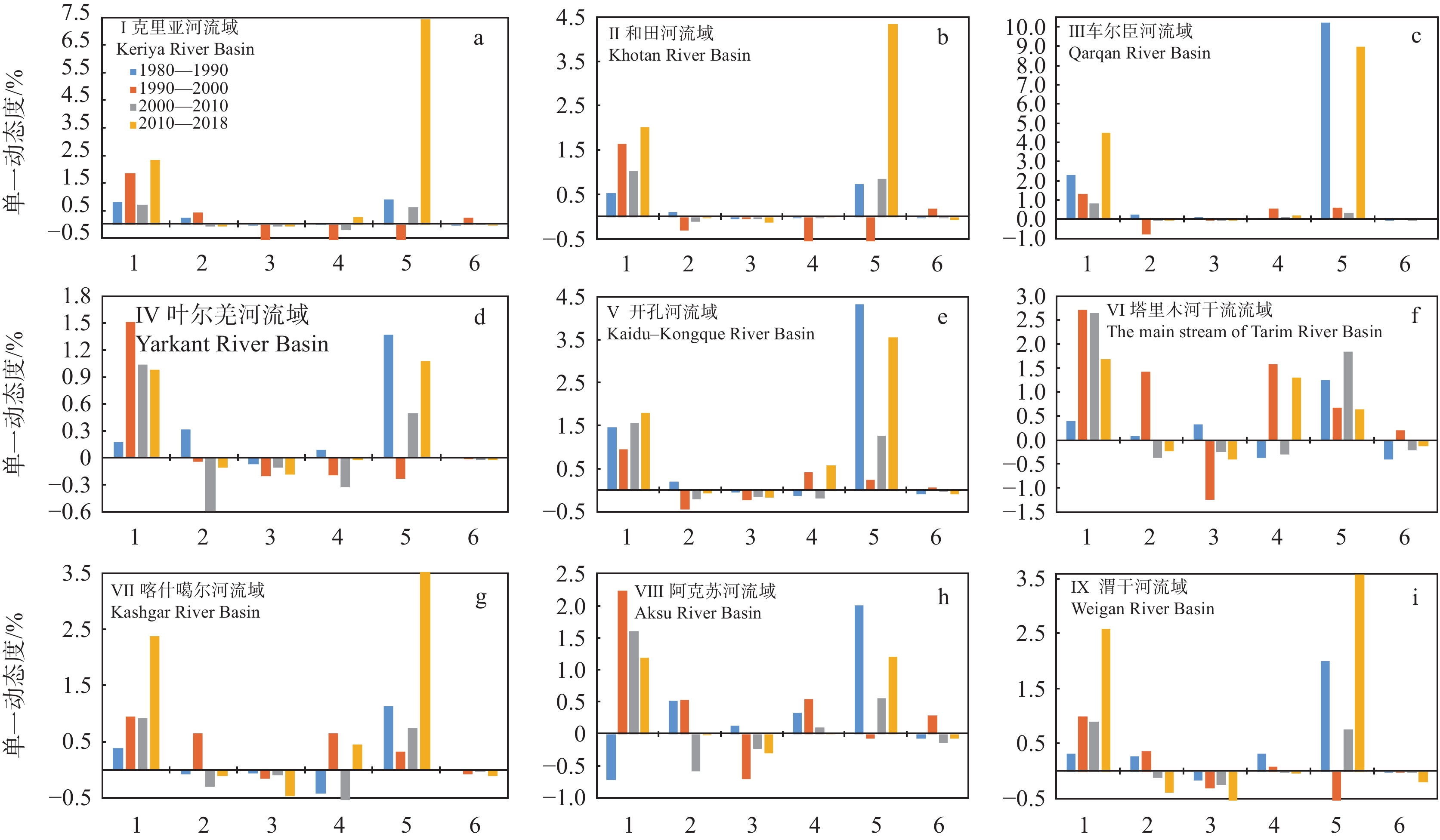
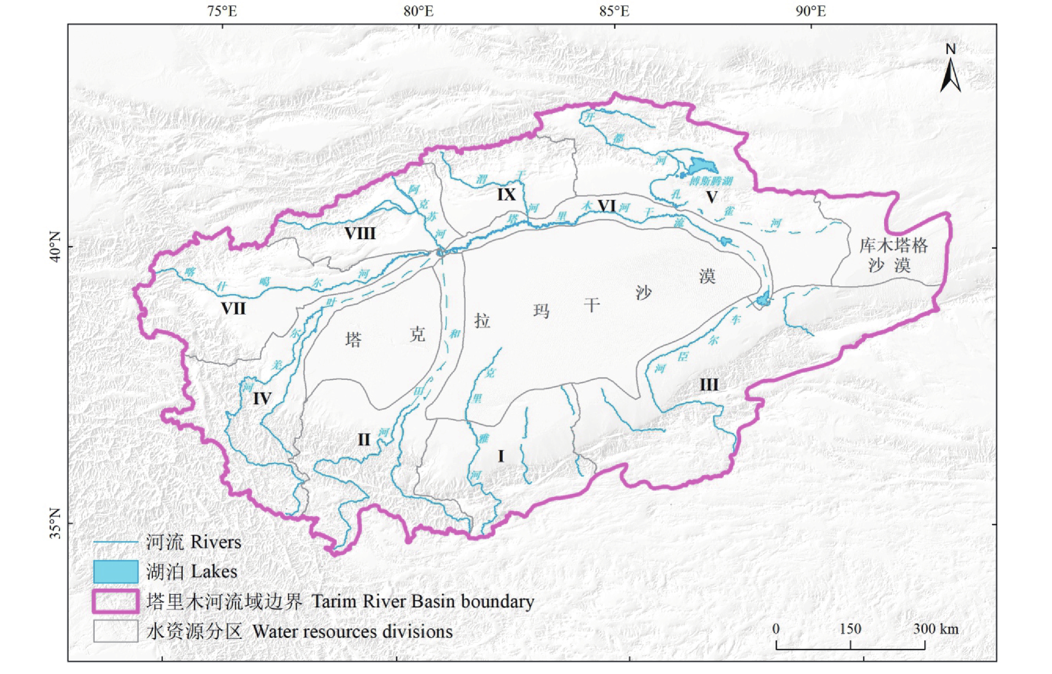
研究方法 基于1980—2018年间共5期遥感影像,结合土地利用动态度、土地利用转移矩阵和人类活动强度指数分析塔里木河流域各水资源分区土地利用变化特征。
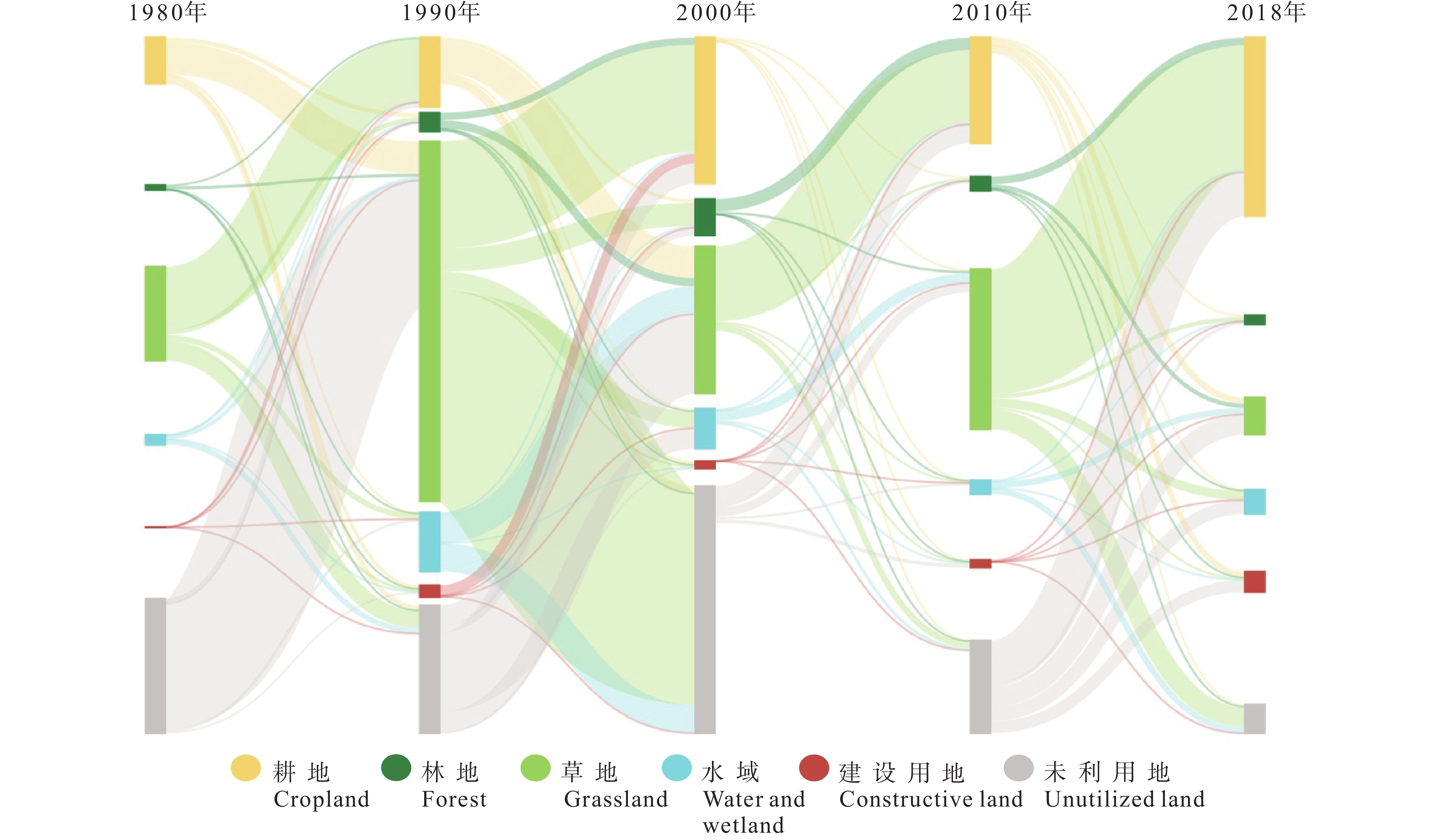
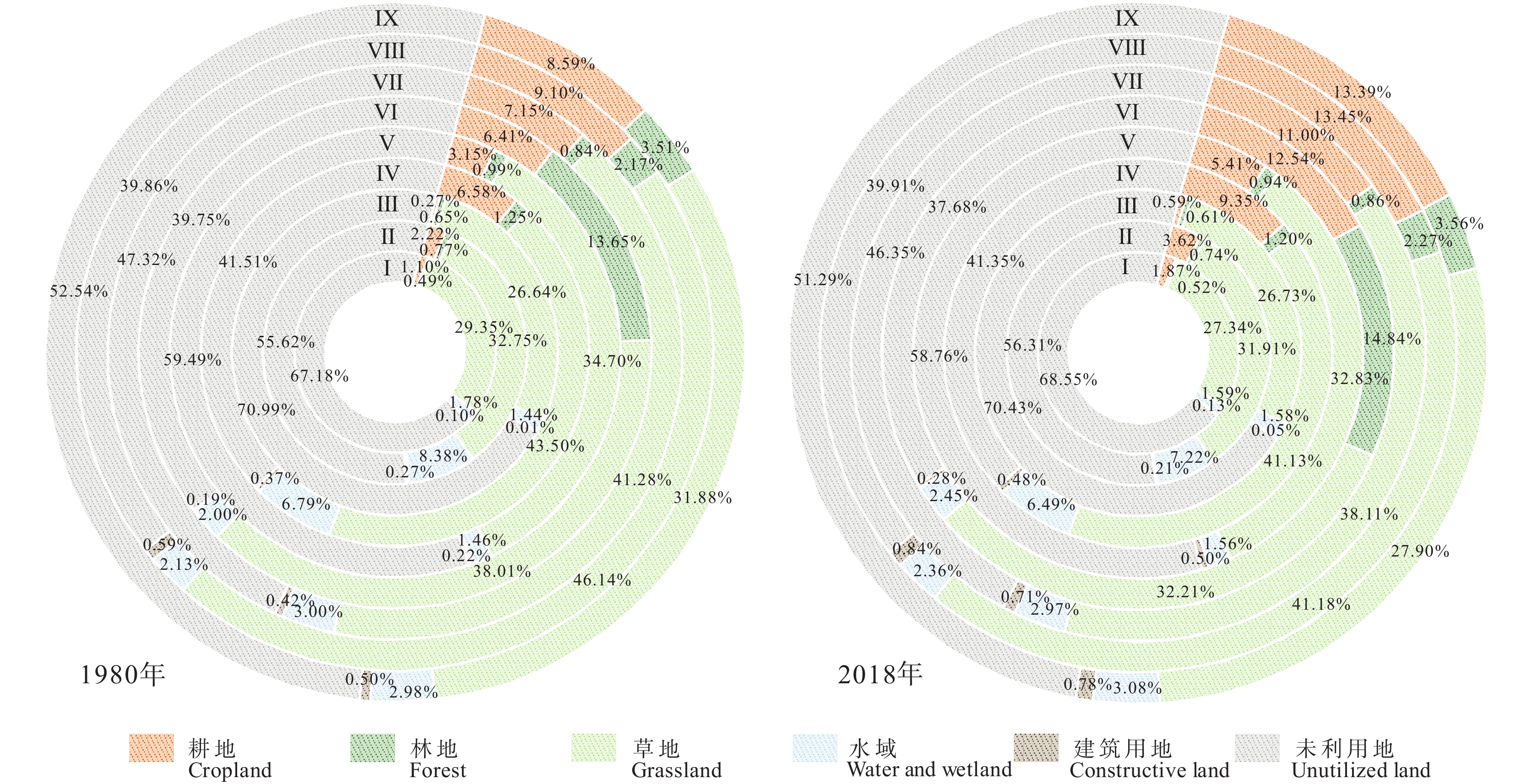
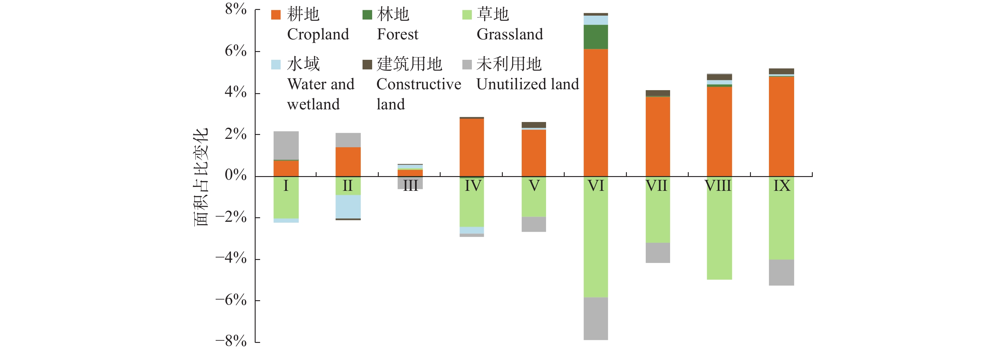
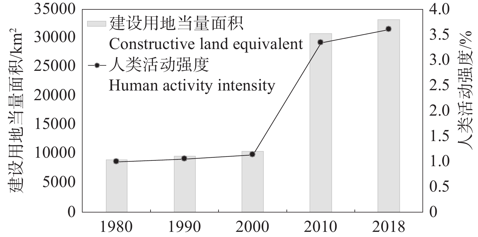
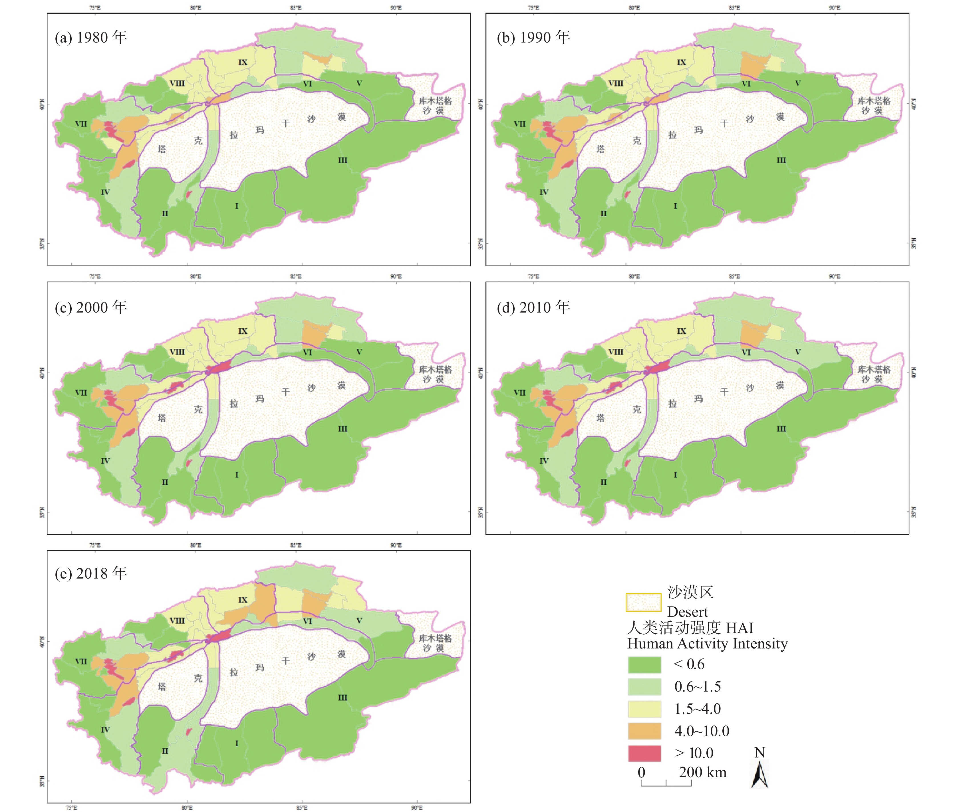
研究结果 近40年中,塔里木河流域耕地、建设用地和林地面积分别增加1.58×10⁴ km2、1.2×10³ km2和347 km2,而草地、未利用地和水域面积分别减少1.33×10⁴ km2、0.32×10⁴ km2和815 km2。各水资源分区中塔里木河干流土地利用类型变化最大,其次为渭干河、阿克苏河和喀什噶尔河流域。自2000年以来,塔里木河流域建设用地当量面积和人类活动强度增加相对较快,特别是2000—2010年间呈显著增长趋势。
结论 塔里木河流域各水资源分区的人类活动强度呈显著的空间差异性。社会经济发展和政策的导向性作用是塔里木河流域土地利用变化和人类活动强度的主要影响因素。
Abstract:This paper is the result of hydrogeological survey engineering.
Objective Land Use/Cover Change (LUCC) caused by human activities is a critical part of global environmental change. LUCC in arid regions has a particularly significant impact on regional hydrology and ecology. Therefore, exploring LUCC and its response to human activities is of great significance to the sustainable development of ecology, resources and environment in the arid inland of Northwest China.
Methods Based on the Landsat images during 1980 to 2018, this paper analyzes the characteristics of land use change in nine divisions of water resources of Tarim River Basin, by the combination of land use dynamic degree, land use transfer matrix and human activity intensity degree.
Results In the past 40 years, cropland, constructive land and forest increased by 1.58×10⁴ km2, 1.2×10³ km2 and 347 km2, respectively. By comparison, grassland, unutilized land, water and wetland decreased by 1.33×10⁴ km2, 0.32×10⁴ km2 and 815 km2, respectively. The main stream of Tarim River Basin has experienced the most significant change in land use types among nine divisions of water resources, followed by Weigan, Aksu and Kashgar river basin. Since 2000, the equivalent area of constructive land and human activity intensity in Tarim River Basin has increased relatively fast, especially from 2000 to 2010.
Conclusions Human activity intensity has showed significant spatial difference among division of water resources. Socio-economic development and policy guidance are major factors leading to land use change and human activity intensity difference.
-

-
表 1 塔里木河流域土地利用/土地覆被分类方案
Table 1. Classification scheme of LUCC in the Tarim River Basin
序号 类别 土地利用类型及范围 1 耕地 指种植农作物的土地,包括旱田和水浇地 2 林地 指经济林、防护林及各类园地等,包括有林地、灌木林、疏木林和其他林地 3 草地 指以草本植物为主,覆盖度在5%以上的各类草地,包括高/中/低覆盖度草地 4 水域 包括河渠、湖泊、水库坑塘、滩地和永久性冰川雪地等 5 建设用地 包括城镇用地、农村居民点和其它建设用地 6 未利用地 包括沙地、戈壁、盐碱地、沼泽地、裸土地、裸岩和其他未利用地等  下载: 导出CSV
表 2 土地利用转移矩阵
Table 2. Transfer matrix of land use and cover types
项目 T2 T2年总计 A1 A2 ··· An T1 A1 S11 S12 ··· S1n S11+···+ S1n A2 S21 S22 ··· S2n S21+···+ S2n ··· ··· ··· ··· ··· ··· An Sn1 Sn2 ··· Snn Sn1+···+ Snn T1年总计 S11+···+ Sn1 S12+···+ Sn2 ··· ···
下载: 导出CSV
表 3 不同土地利用类型的建设用地当量折算系数
Table 3. Conversion index of construction land equivalent of different land use and cover types
序号 土地利用类型 二级土地利用类型 折算系数 1 耕地 水田/旱田 0.2 2 林地 有林地/灌木林/疏林地 0 其他林地 0.2 3 草地 高/中/低覆盖度草地 0 4 水域 湖泊/永久性冰川积雪/滩地 0 河渠 0.067 水库水面 0.6 5 建设用地 城镇用地/农村居民点/其他建设用地 1 6 未利用地 沙地/戈壁/盐碱地/沼泽地/裸土地/裸岩石质地/其他未利用地 0
下载: 导出CSV
表 4 1980—2018年塔里木河流域各土地利用类型面积及其占比
Table 4. The area and proportion of land use types in the Tarim River Basin
土地利用类型 土地利用量(104 km2)及占比 1980年 1990年 2000年 2010年 2018年 耕地 2.6853
(2.29%)2.7809
(3.02%)3.1879
(3.46%)3.6013
(3.91%)4.2668
(4.64%)林地 1.2377
(1.35%)1.2605
(1.37%)1.3310
(1.45%)1.2929
(1.40%)1.2724
(1.38%)草地 24.2407
(26.34%)24.5259
(26.65%)23.6588
(25.71%)23.4081
(25.44%)22.9069
(24.89%)水域 2.2592
(2.46%)2.2581
(2.45%)2.1791
(2.37%)2.1351
(2.32%)2.1776
(2.37%)建筑用地 0.1749
(0.19%)0.2071
(0.23%)0.1897
(0.21%)0.2200
(0.24%)0.2947
(0.32%)未利用地 61.4251
(66.75%)60.9903
(66.28%)61.4763
(66.81%)61.3654
(66.68%)61.1044
(66.40%)
下载: 导出CSV
表 5 1980—2018年塔里木河流域各土地利用类型面积及其占比变化
Table 5. Changes of area and proportion of land use types in the Tarim River Basin
类型 土地利用变化量(104 km2)及占比 1980—1990年 1990—2000年 2000—2010年 2010—2018年 1980—2018年 耕地 0.0956
(0.10%)0.4070
(0.44%)0.4134
(0.45%)0.6655
(0.72%)1.5815
(1.72%)林地 0.0228
(0.02%)0.0704
(0.08%)−0.0381
(−0.04%)−0.0205
(−0.02%)0.0347
(0.04%)草地 0.2852
(0.31%)−0.8670
(−0.94%)−0.2507
(−0.27%)−0.5013
(−0.54%)−1.3338
(−1.45%)水域 −0.0010
(0)−0.0791
(−0.09%)−0.0440
(−0.05%)0.0426
(0.05%)−0.0815
(-0.09%)建筑用地 0.0323
(0.04%)−0.0174
(−0.02%)0.0303
(0.03%)0.0747
(0.08%)0.1198
(0.13%)未利用地 −0.4349
(−0.47%)0.4861
(0.53%)−0.1109
(−0.12%)−0.2610
(−0.28%)−0.3207
(−0.35%)
下载: 导出CSV
表 6 塔里木河流域各水资源分区土地利用程度综合指数及变化
Table 6. Land use degree index and its variation of different water resource divisions in the Tarim River Basin
分区 土地利用程度综合指数变化 2018年 1980—1990年 1990—2000年 2000—2010年 2010—2018年 1980—2018年 综合指数 利用程度 Ⅰ克里亚河 −0.54 0.20 −1.50 0.02 0.74 133.57 低 Ⅱ和田河 0.59 0.16 −1.05 0.41 1.07 147.73 较低 Ⅲ车尔臣河 0.96 0.55 0.00 0.06 0.35 130.26 低 Ⅳ叶尔羌河 3.15 0.18 1.00 0.94 1.02 168.96 较高 Ⅴ开孔河 3.54 1.10 −0.05 0.88 1.61 147.64 较低 Ⅵ塔河干流 8.40 1.88 1.06 3.15 2.30 175.42 高 Ⅶ喀什河 5.40 0.31 1.08 0.97 3.04 166.07 较高 Ⅷ阿克苏河 4.79 −0.16 0.74 2.31 1.90 175.22 高 Ⅸ渭干河 6.62 0.53 0.80 1.09 4.20 163.67 较高
下载: 导出CSV
表 7 1980—2018年塔里木河流域人类活动强度分级
Table 7. Classification of human activity intensity in the Tarim River Basin from 1980 to 2018
等级类型 分级标准/% 1980年 1990年 2000年 2010年 2018年 单元/个 均值/% 单元/个 均值/% 单元/个 均值/% 单元/个 均值/% 单元/个 均值/% 低 <0.6 13 0.25 13 0.27 13 0.28 12 0.28 11 0.33 较低 0.6~1.5 8 0.76 8 0.86 8 0.90 9 0.94 8 1.00 中等 1.5~4 12 2.39 10 2.29 10 2.55 10 2.81 10 2.74 较高 4~10 7 5.80 9 5.81 7 5.35 7 5.79 9 6.52 高 >10 4 14.36 4 15.33 6 14.69 6 15.38 6 18.03
下载: 导出CSV
-
[1] Chen Yaning, Cui Wangcheng, Li Weihong, Chen Yapeng, Zhang Hongfeng. 2003. Utilization of water resources and ecological protection in the Tarim River[J]. Acta Geographica Sinica, 58(2): 177−215 (in Chinese with English abstract).
[2] Chen Yaning, Xu Zongxue. 2004. The impact of global climate change on water resources possibility in Tarim River Basin, Xinjiang[J]. Science in China: Earth Sciences, 34(11): 1047−1053 (in Chinese with English abstract).
[3] Daneshi A, Brouwer R, Najafinejad A, Panahi M, Zarandian A, Maghsood F F. 2021. Modelling the impacts of climate and land use change on water security in a semi−arid forested watershed using InVEST[J]. Journal of Hydrology, 593: 125621. doi: 10.1016/j.jhydrol.2020.125621
[4] Deng Mingjiang, Fan Zili, Xu Hailiang, Zhou Haiying. 2017. Ecological function regionalization of Tarim River Basin[J]. Arid Land Geography, 40(4): 705−717 (in Chinese with English abstract).
[5] Du Qing. 2015. Study on Land Use and Ecological Environment in Tarim River Basin[D]. Urumqi: Chinese Academy of Sciences, 1–108 (in Chinese with English abstract).
[6] Duan Quntao, Luo Lihui. 2021. Summary and prospect of spatialization method of human activity intensity: Taking the Qinghai−Xizang Plateau as an example[J]. Journal of Glaciology and Geocryology, 43(5): 1582−1593 (in Chinese with English abstract).
[7] Duan Zhengrong, Zubaidai·Muyibula, Xia Jianxin, Liu Rongxia. 2018. Land use/cover temporal−spatial change and driving force study in Aksu Oasis during the last 25 years[J]. Journal of Basic Science and Engineering, 26(2): 413−426 (in Chinese with English abstract).
[8] Eqide·Issac. 2022. Study on Land Use Change and Ecological Security Early Warning in Aksu River Basin[D]. Urumqi: Xinjiang Normal University, 1–60 (in Chinese with English abstract).
[9] Gao Yue, Lin Xinping. 2019. Spatial and temporal variation of land use structure in inland river basin of arid area: Take the Tarim River Basin as an example[J]. Hubei Agricultural Sciences, 58(7): 62−66 (in Chinese with English abstract).
[10] Guo Hongwei, Xu Hailiang, Zhao Xinfeng, Ling Hongbo. 2017. The maximum irrigation area and overload situations of the mainstream of Tarim river basin[J]. Acta Scientiarum Naturalium Universitatis Sunyatseni, 56(2): 140−150 (in Chinese with English abstract).
[11] He Lingyun, Haimiti Yimiti, Li Xiehui. 2005. Analysis on the change of cultivated land in the Hetian District[J]. Research of Soil and Water Conservation, (1): 83−86 (in Chinese with English abstract).
[12] Hou Yifeng, Wang Yang, Zhang Shuai. 2020. Impact of human activities on land use change in Weigan−Kuqa River Basin[J]. Southwest China Journal of Agricultural Sciences, 33(8): 1760−1768 (in Chinese with English abstract).
[13] Hu Xu, Nie Yong, Xu Xia, Jiang Sheng, Zhang Yili. 2020. Monitoring land−use change in Hetian Tarim Basin, China using satellite remote sensing observation between 1990 and 2016[J]. Progress in Geography, 39(4): 577−590 (in Chinese with English abstract). doi: 10.18306/dlkxjz.2020.04.005
[14] Jiang Shan, Shi Xufei, Guo Changlai, Feng Yulin, Sun Xiubo, Sun Jiaquan, Ni Jin. 2023. Land use changes and simulation prediction in Daling River Basin based on CA−Markov mode[J]. Geology and Resources, 32(5): 624–632 (in Chinese with English abstract).
[15] Li Yan'e, Wang Huaqi, Liu Jiang, Ma Hongna. 2023. Spatial and temporal distribution and driving factors of ecosystem carbon sink in Northwest China[J]. Northwestern Geology, 56(4): 185–195 (in Chinese with English abstract).
[16] Liu Jing, Long Aihua, Li Jiang, Yu Jiawen, Zhang Ji. 2019. Analysis on runoff evolution laws and trends of three source−streams of Tarim River in recent 60 years[J]. Water Resources and Hydropower Engineering, 50(12): 10−17 (in Chinese with English abstract).
[17] Liu Wei. 2019. Effects of Climate Change and Human Activities on Land Use Change in the Kaikong River Basin, China[D]. Shanghai: East China Normal University, 1–87 (in Chinese with English abstract).
[18] Mansur Sabit, Lutpulla Imin. 2011. Land use change and its ecoeffects in Southern Xinjiang, China[J]. Scientia Geographica Sinica, 31(4): 440−446 (in Chinese with English abstract).
[19] Murray K S, Rogers D T. 1999. Ground water, vulnerability, browfield redevelopement and land use planning[J]. Journal of Environmental Planning and Management, 42(6): 801−806. doi: 10.1080/09640569910830
[20] Pielke R A, Avissar R. 1990. Influence of landscape structure on local and regioal climate[J]. Landscape Ecology, 4: 133−155. doi: 10.1007/BF00132857
[21] Ran Qiyun. 2017. Spatio−temporal Change Characteristics and Analysis of Surface Water Resources in the Tarim River Basin[D]. Chongqing: Chongqing Jiaotong University, 1–86 (in Chinese with English abstract).
[22] Sanderson E W, Jaiteh M, Levy M A, Redford K H, Wannebo A V, Woolmer G. 2002. The human footprint and the last of the wild[J]. Bioscience, 52: 891−904. doi: 10.1641/0006-3568(2002)052[0891:THFATL]2.0.CO;2
[23] Schmidt M. 2008. The sankey diagram in energy and material flow management−Part II: Methodology and current applications[J]. Journal of Industrial Ecology, 12(2): 173−185. doi: 10.1111/j.1530-9290.2008.00015.x
[24] Shi Yongliang, Wang Rusong, Zhou Haibo, Chen Liang. 2006. Land use change and its ecological effects in the ecotone of Southern Xinjiang Uyghur Autonomous Region: A case study of Akesu City area[J]. Chinese Journal of Ecology, (7): 753−758 (in Chinese with English abstract).
[25] Song Fengjiao. 2021. Study on Spatio−temporal Change and Benefit Evaluation of Cultivated Land Use in Xinjiang[D]. Shihezi: Shihezi University, 1–70 (in Chinese with English abstract).
[26] Strassburg, B B N. , Latawiec, A E, Barioni, L G, Nobre, C A, da Silva V P, Valentin J F, Vianna M, Assad E D. 2014. When enough should be enough: Improving the use of current agricultural lands could meet production demands and spare natural habitats in Brazil[J]. Global Environmental Change−human and Policy Dimensions, 28: 84–97.
[27] Statistic Bureau of Xinjiang Uygur Autonomous Region. 2001. Xinjiang Statistical Yearbook[M]. Beijing: China Statistics Press (in Chinese).
[28] Statistic Bureau of Xinjiang Uygur Autonomous Region. 2019. Xinjiang Statistical Yearbook[M]. Beijing: China Statistics Press (in Chinese).
[29] Sun Meiqin, Zhao Chengyi, Shi Fengzhi, Peng Dongmei, Wu Shixin. 2013. Analysis on land use change in the mainstream area of the Tarim River in recent 20 years[J]. Arid Zone Research, 30(1): 16−21 (in Chinese with English abstract).
[30] Turner B L, Kasperson R E, Matson P A, McCarthy J J, Corell R W, Christensene L, Eckley N, Kasperson J X, Luers A, Martello M L, Polsky C, Pulsipher A, Schiller A. 2003. A frame work for vulnerability analysis in sustainability science[J]. Proceedings of the National Academy of Sciences, 100(14): 8074−8079. doi: 10.1073/pnas.1231335100
[31] Wang Dan, Wu Shixin, Zhang Shouyu. 2017. Expansion of both cultivated and construction land in Xinjiang since the late 1980s[J]. Arid Land Geography, 40(1): 188−196 (in Chinese with English abstract).
[32] Wang Jing, Xiao Haifeng. 2018. Optimization of the distribution of cotton production in Xinjiang under the view of cultivated land ecological security[J]. Arid Land Geography, 41(4): 833−843 (in Chinese with English abstract).
[33] Wang L C, Yu K, Chang L, Zhang J, Tang T, Yin L H, Gu X F, Dong J Q, Li Y, Jiang J, Yang B C, Wang Q. 2021. Response of glacier area variation to climate change in the Kaidu−Kongque river basin, Southern Tianshan Mountains during the last 20 years[J]. China Geology, 4(3): 389−401.
[34] Wang Shanshan, Wang Jinlin, Zhou Kefa, Wang Wei, Wan Yingcai. 2021. Response of land−use/land change to ecological water conveyance in the lower reach of Tarim River[J]. Water Resource Protection, 37(2): 69−74,80 (in Chinese with English abstract).
[35] Wang Xiulan, Bao Yuhai. 1990. Study on the methods of land use dynamic change research[J]. Progress in Geography, (1): 83−89 (in Chinese with English abstract).
[36] Wang Xufan. 2019. Research and Implementation on Visual Expression of Land Cover Temporal and Spatial Change[D]. Beijing: China University of Geosciences (Beijing), 1–73 (in Chinese with English abstract).
[37] Xia Tingting. 2022. Analysis of Characteristics and Driving Factors of Land Use Change in the Tarim River Basin[D]. Urumqi: Xinjiang Agricultural University, 1–55 (in Chinese with English abstract).
[38] Xu Lan, Zhao Yi. 1993. Forecast of land use pattern change in Dongling District of Shenyang: An application of Markov process[J]. Chinese Journal of Applied Ecology, (3): 272−277 (in Chinese with English abstract).
[39] Xu Yong, Sun Xiaoyi, Tang Qing. 2015. Human activity intensity of land surface: Concept, method and application in China[J]. Acta Geographica Sinica, 70(7): 1068−1079 (in Chinese with English abstract).
[40] Yan Yiliang. 2022. Research on Temporal and Spatial Variation of Human Activity Intensity in Kashgar Prefecture Based on Land Use[D]. Urumqi: Xinjiang Normal University, 1–80 (in Chinese with English abstract).
[41] Yang Guanghua, Bao Anming, Chen Xi, Liu Hailong, Huang Ying, Dai Shuyong. 2010. Vegetation cover change with climate and land use variation along main stream of Tarim River[J]. Journal of Desert Research, 30(6): 1389−1397 (in Chinese with English abstract).
[42] Yang Zhihua. 2020. Study on Farmers' Willingness to Protect Cultivated Land and Influencing Factors under the Background of Cultivated Land Fertility Protection Subsidy Policy: A Case of Qitai in Xinjiang[D]. Urumqi: Xinjiang Agricultural University, 1–74 (in Chinese with English abstract).
[43] Yin Lihe, Zhang Jun, Wang Zhe, Dong Jiaqiu, Chang Liang, Li Chunyan, Zhang Pengwei, Gu Xiaofan, Nie Zhenlong. 2021. Groundwater circulation patterns and its resources assessment of inland river catchments in northwestern China[J]. Geology in China, 48(4): 1094−1111 (in Chinese with English abstract).
[44] Zhang Chunyi, Wahap Halik, Ma Yan. 2007. The study on population driving forces to cultivated land change in Hotan Oases[J]. Journal of Arid Land Resources and Environment, (2): 85−89 (in Chinese with English abstract).
[45] Zhang Junfeng, Meng Fanhao, Bao Anming, Li Changchun, Qi Xiudong, Liu Tie, Zhang Pengfei. 2018. LUCC analysis of the upstream of the Kongqi River, Xinjiang, China[J]. Journal of Desert Research, 38(3): 664−672 (in Chinese with English abstract).
[46] Zhang Lingli. 2015. Study on the Compensation Mechanism of Ecological Migrants in Sinkiang[D]. Shihezi: Shihezi University, 1–168 (in Chinese with English abstract).
[47] Zhang Zhengwen. 2013. The Research on the Development of Cotton Industry of Xinjiang[D]. Urumqi: Xinjiang University, 1–59 (in Chinese with English abstract).
[48] Zhao Shaojun, Wei Qiang, Zhao Xinfeng. 2018. Analysis of the change process and land use types in the main stream of Tarim River[J]. Journal of Xinjiang Agricultural University, 41(4): 298−306 (in Chinese with English abstract).
[49] Zhou Ruitao, Zheng Hang, Liu Yueyi. 2021. Understanding the evolution of the Tarim River Oasis[J]. Water Resources and Hydropower Engineefing, 52(2): 155−164 (in Chinese with English abstract).
[50] Zhuang Dafang, Liu Jiyuan. 1997. Study on the model of regional differentiation of land use degree in China[J]. Journal of Natural Resources, (2): 105−111 (in Chinese with English abstract).
[51] 艾克旦·依萨克. 2022. 阿克苏河流域土地利用变化及生态安全预警研究[D]. 乌鲁木齐: 新疆师范大学, 1–60.
[52] 陈亚宁, 崔旺诚, 李卫红, 张元明. 2003. 塔里木河的水资源利用与生态保护[J]. 地理学报, 58(2): 177−215.
[53] 陈亚宁, 徐宗学. 2004. 全球气候变化对新疆塔里木河流域水资源的可能性影响[J]. 中国科学:地球科学, 34(11): 1047−1053.
[54] 邓铭江, 樊自立, 徐海量, 周海鹰. 2017. 塔里木河流域生态功能区划研究[J]. 干旱区地理, 40(4): 705−717.
[55] 杜清. 2015. 塔里木河流域土地利用及生态环境状况研究[D]. 乌鲁木齐: 中国科学院大学, 1–108.
[56] 段群滔, 罗立辉. 2021. 人类活动强度空间化方法综述与展望[J]. 冰川冻土, 43(5): 1582−1593.
[57] 段峥嵘, 祖拜代·木依布拉, 夏建新, 刘荣霞. 2018. 近25年阿克苏绿洲土地利用时空变化及其驱动力分析[J]. 应用基础与工程科学学报, 26(2): 413−426.
[58] 高玥, 刘新平. 2019. 干旱区内陆河流域土地利用结构时空变化分析——以塔里木河流域为例[J]. 湖北农业科学, 58(7): 62−66.
[59] 郭宏伟, 徐海量, 赵新风, 凌红波. 2017. 塔里木河流域最大灌溉面积与超载情况探讨[J]. 中山大学学报(自然科学版), 56(2): 140−150.
[60] 贺凌云, 海米提·依米提, 李谢辉. 2005. 和田地区近五十年耕地变化分析[J]. 水土保持研究, (1): 83−86.
[61] 侯一峰, 汪洋, 张帅. 2020. 人类活动对渭干—库车河流域土地利用变化的影响[J]. 西南农业学报, 33(8): 1760−1768.
[62] 胡栩, 聂勇, 徐霞, 蒋盛, 张镱锂. 2020. 塔里木盆地南缘和田地区土地利用变化的遥感研究[J]. 地理科学进展, 39(4): 577−590.
[63] 江山, 石旭飞, 郭常来, 冯雨林, 孙秀波, 孙家全, 倪金. 2023. 基于CA−Markov模型的大凌河流域土地利用变化与模拟预测研究[J]. 地质与资源, 32(5): 624–632.
[64] 李彦娥, 王化齐, 刘江, 马红娜. 2023. 西北地区生态系统碳汇时空分布特征及相关驱动因子分析[J]. 西北地质, 56(4): 185–195.
[65] 刘静, 龙爱华, 李江, 於嘉闻, 张继. 2019. 近60年塔里木河三源流径流演变规律与趋势分析[J]. 水利水电技术, 50(12): 10−17.
[66] 刘薇. 2019. 开孔河流域气候变化和人类活动对土地利用变化的影响[D]. 上海: 华东师范大学, 1–87.
[67] 满苏尔·沙比提, 陆吐布拉·依明. 2011. 新疆南疆地区土地利用变化及其生态效应[J]. 地理科学, 31(4): 440−446.
[68] 冉启云. 2017. 塔里木河流域地表水体时空变化特征探究及分析[D]. 重庆: 重庆交通大学, 1–86.
[69] 史永亮, 王如松, 周海波, 陈亮. 2006. 南疆生态脆弱区土地利用变化及其生态影响评价——以新疆阿克苏市为例[J]. 生态学杂志, (7): 753−758.
[70] 宋风娇. 2021. 新疆耕地利用时空变化及效益评价研究[D]. 石河子: 石河子大学, 1–70.
[71] 孙美琴, 赵成义, 施枫芝, 彭冬梅, 吴世新. 2013. 近20a塔里木河干流区土地利用变化特征[J]. 干旱区研究, 30(1): 16−21.
[72] 王丹, 吴世新, 张寿雨. 2017. 新疆20世纪80年代末以来耕地与建设用地扩张分析[J]. 干旱区地理, 40(1): 188−196.
[73] 王晶, 肖海峰. 2018. 耕地生态安全视域下棉花生产布局优化问题研究——以新疆为例[J]. 干旱区地理, 41(4): 833−843.
[74] 王珊珊, 王金林, 周可法, 汪玮, 万应彩. 2021. 塔里木河下游土地利用/覆被变化对生态输水的响应[J]. 水资源保护, 37(2): 69−74,80.
[75] 王秀兰, 包玉海. 1999. 土地利用动态变化研究方法探讨[J]. 地理科学进展, (1): 83−89.
[76] 王徐凡. 2019. 土地覆被时空变化的可视化表达研究与实现[D]. 北京: 中国地质大学(北京), 1–73.
[77] 夏婷婷. 2022. 塔里木河流域土地利用变化及驱动因素分析[D]. 乌鲁木齐: 新疆农业大学, 1–55.
[78] 新疆维吾尔自治区统计局编. 2001. 新疆统计年鉴[M]. 北京: 中国统计出版社.
[79] 新疆维吾尔自治区统计局编. 2019. 新疆统计年鉴[M]. 北京: 中国统计出版社.
[80] 徐岚, 赵羿. 1993. 利用马尔柯夫过程预测东陵区土地利用格局的变化[J]. 应用生态学报, (3): 272−277.
[81] 徐勇, 孙晓一, 汤青. 2015. 陆地表层人类活动强度: 概念、方法及应用[J]. 地理学报, 70(7): 1068−1079.
[82] 闫伊亮. 2022. 基于土地利用的喀什地区人类活动强度时空变化研究[D]. 乌鲁木齐: 新疆师范大学, 1–80.
[83] 杨光华, 包安明, 陈曦, 刘海隆, 黄莹, 代述勇. 2010. 气候和土地利用变化对塔里木河干流区植被覆盖变化的影响[J]. 中国沙漠, 30(6): 1389−1397.
[84] 杨志华. 2020. 耕地地力保护补贴政策背景下农户耕地保护意愿及影响因素研究——以新疆奇台县为例[D]. 乌鲁木齐: 新疆农业大学, 1–74.
[85] 尹立河, 张俊, 王哲, 董佳秋, 常亮, 李春燕, 张鹏伟, 顾小凡, 聂振龙. 2021. 西北内陆河流域地下水循环特征与地下水资源评价[J]. 中国地质, 48(4): 1094−1111.
[86] 张春轶, 瓦哈甫·哈力克, 马燕. 2007. 和田绿洲耕地变化的人口驱动因素研究[J]. 干旱区资源与环境, (2): 85−89.
[87] 张灵俐. 2015. 新疆生态移民补偿机制研究[D]. 石河子: 石河子大学, 1–168.
[88] 张军峰, 孟凡浩, 包安明, 李长春, 齐修东, 刘铁, 张鹏飞. 2018. 新疆孔雀河流域人工绿洲近40年土地利用/覆被变化[J]. 中国沙漠, 38(3): 664−672.
[89] 张正文. 2013. 新疆棉花产业发展研究[D]. 乌鲁木齐: 新疆大学, 1–59.
[90] 赵少军, 魏强, 赵新风. 2018. 塔里木河干流土地利用变化类型及过程分析[J]. 新疆农业大学学报, 41(4): 298−306.
[91] 周瑞涛, 郑航, 刘悦忆. 2021. 塔里木河流域的绿洲迁移研究[J]. 水利水电技术, 52(2): 155−164.
[92] 庄大方, 刘纪远. 1997. 中国土地利用程度的区域分异模型研究[J]. 自然资源学报, (2): 105−111.
-


图(9)
表(7)
计量
- 文章访问数: 2317
- PDF下载数: 228
- 施引文献: 0