

LANDSLIDE SUSCEPTIBILITY ASSESSMENT OF NEW JING-ZHANG HIGH-SPEED RAILWAY BASED ON GIS AND INFORMATION VALUE MODEL
-
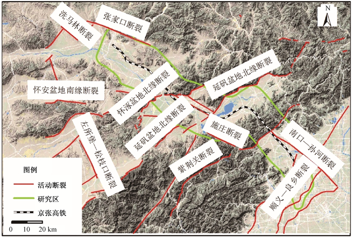
摘要: 新建京张铁路不仅是2022年北京冬奥会的配套交通保障设施,同时也是京包兰交通廊道的重要组成部分。在京张高铁沿线滑坡灾害调查的基础上,对影响滑坡灾害发育的相关因子进行统计分析,选取斜坡坡高、坡度、坡向、归一化植被指数、工程地质岩组、活动断裂、河流、年平均降雨量、地震和人类工程活动等10个要素作为评价模型计算的基本变量和数值化参数,采用基于GIS的信息量模型法对在建京张高铁沿线及邻区进行了滑坡灾害易发性评价,并将评价结果划分为5个等级:极低易发区、低易发区、中易发区、高易发区和极高易发区。结合野外调查成果,对评价结果的可信度进行了检验分析,评价结果与实际灾害发生情况基本吻合,研究结果可为京张高铁建设、减灾防灾提供基础依据。Abstract: New Jing-Zhang high-speed railway is not only an important supporting transportation infrastructure for the 2022 winter Olympics in Beijing, but also an important part of the eastern section of the "eight vertical and eight horizontal" Jinglan corridor that the state plans to implement. Based on the investigation of the landslide disaster along the Jing-Zhang high-speed railway, a statistical analysis on the correlation factors affecting the development of geological disasters are made in this article. A total of 10 variables are analyzed as input variables, namely topography (height, slope and aspect), vegetation coverage ratio, engineering rock group, fault, river, rainfall, earthquake and human activity of the study area. The results of landslide susceptibility assessment based on GIS and information value model of New Jing-Zhang High-speed Rail will be divided into 5 grades:extremely high susceptible, high susceptible, moderate susceptible, low susceptible and extremely low susceptible. The results of the model preferably inosculate with the field surveying, and the results of this article can provide a valid basis for the railway construction in the future.
-

-
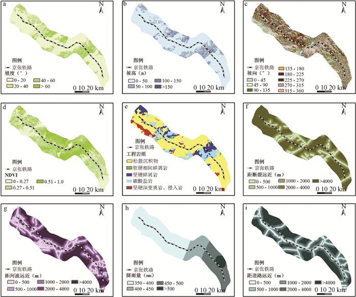
表 1 信息量与计算参数
Table 1. Information and calculation parameters
因子 类别 信息量值 排序 工程岩组 松散沉积物 0.0187 22 软硬相间碎屑、浅变质岩 0.9738 4 坚硬碎屑岩 -0.3741 38 碳酸盐岩 -0.0248 25 坚硬深变质岩、侵入岩 -0.3752 39 断层 < 500 m 0.5850 9 500~1000 m -0.0154 35 1000~2000 m -0.3451 18 2000~4000 m 0.2308 28 >4000 m -0.1148 13 河流 < 500 m 0.4261 11 500~1000 m 0.5392 34 1000~2000 m -0.3150 20 2000~4000 m 0.1470 42 >4000 m -0.6626 41 降雨量 350~400 mm -0.5459 6 400~450 mm 0.7361 7 450~500 mm 0.6462 31 >500 mm -0.1664 24 地震动 0.15 g -0.4974 40 0.20 g 0.1381 21 植被覆盖率 0~0.27 0.2974 15 0.27~0.51 -0.1122 27 0.51~1.0 -0.2097 33 坡度 0~20° -0.7591 44 20~40° 1.1824 3 40~60° 0.3615 14 >60° 0.8687 5 坡向 0~45° -0.2027 32 45~90° 0.2429 17 90~135° -0.1197 29 135~180° -0.3618 36 180~225° 0.0186 23 225~270° -0.8150 45 270~315° 0.5644 24 315~360° 0.2095 19 坡高 0~50 m -0.6947 43 50~100 m 0.6000 8 100~150 m 1.3104 2 >150 m 1.7675 1 人类工程活动 < 500 m 0.4505 12 500~1000 m 0.2548 16 1000~2000 m -0.3715 37 2000~4000 m -0.0263 26 >4000 m -0.1651 30  下载: 导出CSV
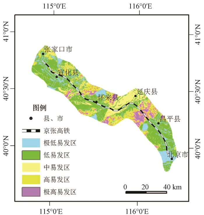
表 2 划分的易发性等级与实际灾害分布的对比
Table 2. Comparison between evaluation results and actual disaster distribution
危险度 单元数 a/% c/个 b/% b/a 极低易发区 83340 17.33 0 0 0 低易发区 190403 39.60 4 7.40 0.1868 中易发区 97082 20.19 19 35.18 1.7424 高易发区 73358 15.25 15 20.78 1.3626 极高易发区 36595 7.61 16 29.64 3.8948 总计 490778 100 54 100 注:a为本类易发性等级的面积占研究区总面积的百分比;b为落在该易发性分区内的灾害占灾害点总数的百分比;c为落在该类易发性分区内的灾害数量。
下载: 导出CSV
-
Ohlmacher G C, Davis J C. Using multiple logistic regression and GIS technology to predict landslide hazard in northeast Kansas, USA[J]. Engineering Geology, 2003, 69(3/4):331~343. https://link.springer.com/article/10.1007/s00254-008-1342-9
Dai B F C, Lee C F. Landslide characteristics and slope instability modeling using GIS, Lantau Island, Hong Kong[J].Geomorphology, 2002, 42(3/4):213~228. https://www.sciencedirect.com/science/article/pii/S0169555X01000873
Guo C B, Montgomery D R, Zhang Y S, et al. Quantitative assessment of landslide susceptibility along the Xianshuihe fault zone, Tibetan Plateau, China[J]. Geomorphology, 2015, 248:93~110. doi: 10.1016/j.geomorph.2015.07.012
Wang QQ, Li W P. A GIS-based comparative evaluation of analytical hierarchy process and frequency ratio models for landslide susceptibility mapping[J]. Physical Geography, 2017, 38(4):318~337. doi: 10.1080/02723646.2017.1294522
杜国梁, 张永双, 高金川, 等.基于GIS的白龙江流域甘肃段滑坡易发性评价[J].地质力学学报, 2016, 22(1):1~11. http://journal.geomech.ac.cn/ch/reader/view_abstract.aspx?file_no=20160101&flag=1
DU Guoliang, ZHANG Yongshuang, GAOJinchuan, et al. Landslide susceptibility assessment based on GIS in Bailongjiang watershed, Gansu province[J]. Journal of Geomechanics, 2016, 22(1):1~11. (in Chinese with English abstract) http://journal.geomech.ac.cn/ch/reader/view_abstract.aspx?file_no=20160101&flag=1
向喜琼, 黄润秋.基于GIS的人工神经网络模型在地质灾害危险性区划中的应用[J].中国地质灾害与防治学报, 2000, 11(3):23~27. http://doi.wanfangdata.com.cn/10.3969/j.issn.1003-8035.2000.03.006
Xiang Xiqiong, Huang Runqiu. Application of GIS-based artificial neural networks on assessment of geohazardsrisk[J]. The Chinese Journal of Geological Hazard and Control, 2000, 11(3):23~27. (in Chinese with English abstract) http://doi.wanfangdata.com.cn/10.3969/j.issn.1003-8035.2000.03.006
Zhang Y S, Yang Z H, Guo C B, et al. Predicting landslide scenes under potential earthquake scenarios in the Xianshuihe fault zone, Southwest China[J]. Journal of Mountain Science, 2017, 14(7):1262~1278. doi: 10.1007/s11629-017-4363-6
Dai F C, Lee C F, Ngai Y Y. Landslide risk assessment and management:an overview[J]. Engineering Geology, 2002, 64(1):65~87. doi: 10.1016/S0013-7952(01)00093-X
张春山, 吴满路, 张业成.地质灾害风险评价方法及展望[J].自然灾害学报, 2003, 12(1):96~102. http://doi.wanfangdata.com.cn/10.3969/j.issn.1004-4574.2003.01.016
ZHANG Chunshan, WU Manlu, ZHANG Yecheng. Method and prospect of geological disaster risk assessment[J]. Journal of Natural Disasters, 2003, 12(1):96~102. (in Chinese with English abstract) http://doi.wanfangdata.com.cn/10.3969/j.issn.1004-4574.2003.01.016
马寅生, 张业成, 张春山, 等.地质灾害风险评价的理论与方法[J].地质力学学报, 2004, 10(1):7~18. http://journal.geomech.ac.cn/ch/reader/view_abstract.aspx?file_no=20040103&flag=1
MA Yinsheng, ZHANG Yecheng, ZHANG Chunshan, et al. Theory and approaches to the risk evaluation of geological hazards[J]. Journal of Geomechanics, 2004, 10(1):7~18. (in Chinese with English abstract) http://journal.geomech.ac.cn/ch/reader/view_abstract.aspx?file_no=20040103&flag=1
Van Westen C J, VanAsch T W J, Soeters R. Landslide hazard and risk zonation-why is it still so difficult?[J]. Bulletin of Engineering Geology and the Environment, 2006, 65(2):167~184. doi: 10.1007/s10064-005-0023-0
石菊松, 石玲, 吴树仁.滑坡风险评估的难点和进展[J].地质论评, 2007, 53(6):797~806. http://www.cnki.com.cn/Article/CJFDTotal-DLKJ201203014.htm
SHI Jusong, SHI Ling, WU Shuren. Difficulties and problematical aspects of landslide risk assessment:an overview[J]. Geological Review, 2007, 53(6):797~806. (in Chinese with English abstract) http://www.cnki.com.cn/Article/CJFDTotal-DLKJ201203014.htm
胡瑞林, 范林峰, 王珊珊, 等.滑坡风险评价的理论与方法研究[J].工程地质学报, 2013, 21(1):76~84. http://d.old.wanfangdata.com.cn/Periodical/gcdzxb201301009
HU Ruilin, FAN Linfeng, WANGShanshan, et al. Theory and method for landslide risk assessment-current status and future development[J]. Journal of Engineering Geology, 2013, 21(1):76~84. (in Chinese with English abstract) http://d.old.wanfangdata.com.cn/Periodical/gcdzxb201301009
缪信, 汤明高, 王自高, 等.地质灾害危险性评价模型的比较分析与应用[J].水利水电技术, 2016, 47(4):119~122. http://d.old.wanfangdata.com.cn/Periodical/slsdjs201604026
MIAO Xin, TANGMinggao, WANG Zigao, et al. Comparative analysis and application of model for assessment on risk of geological hazard[J]. Water Resources and Hydropower Engineering, 2016, 47(4):119~122. (inChinesewith English abstract) http://d.old.wanfangdata.com.cn/Periodical/slsdjs201604026
吴树仁, 石菊松, 张春山, 等.地质灾害风险评估技术指南初论[J].地质通报, 2009, 28(8):995~1005. http://www.doc88.com/p-0092023776545.html
WU Shuren, SHI Jusong, ZHANG Chunshan, et al. Preliminary discussion on technical guideline for geohazard risk assessment[J]. Geological Bulletin of China, 2009, 28(8):995~1005. (in Chinese with English abstract) http://www.doc88.com/p-0092023776545.html
高克昌, 崔鹏, 赵纯勇, 等.基于地理信息系统和信息量模型的滑坡危险性评价——以重庆万州为例[J].岩石力学与工程学报, 2006, 25(5):991~996. http://www.cqvip.com/Main/Detail.aspx?id=21816737
GAOKechang, CUI Peng, ZHAO Chunyong, et al. Landslide hazard evaluation of Wanzhou based on GIS information value method in the three gorges reservoir[J]. Chinese Journal of Rock Mechanics and Engineering, 2006, 25(5):991~996. (in Chinese with English abstract) http://www.cqvip.com/Main/Detail.aspx?id=21816737
阮沈勇, 黄润秋.基于GIS的信息量法模型在地质灾害危险性区划中的应用[J].成都理工学院学报, 2001, 28(1):89~92. http://doi.wanfangdata.com.cn/10.3969/j.issn.1671-9727.2001.01.018
RUANShenyong, HUANG Runqiu.Application of GIS-based information model on assessment of geological hazards risk[J]. Journal of Chengdu University of Technology, 2001, 28(1):89~92. (in Chinese with English abstract) http://doi.wanfangdata.com.cn/10.3969/j.issn.1671-9727.2001.01.018
辛鹏. 陕西省麟游县地质灾害危险性评价[D]. 北京: 中国地质科学院, 2010.
http://cdmd.cnki.com.cn/Article/CDMD-82501-2011012298.htm XINPeng. Study on landslide hazard assessment inLinyou county in Shaanxi province[D]. Beijing: Chinese Academy of Geological Sciences, 2010. (in Chinese with English abstract)
王涛. 汶川地震重灾区地质灾害危险性评估研究[D]. 北京: 中国地质科学院, 2010.
http://cdmd.cnki.com.cn/Article/CDMD-82501-2011012316.htm WANG Tao. Study on seismic landslide hazard assessment inWenchuan earthquake severly afflicted area[D]. Beijing: Chinese Academy of Geological Science, 2010. (in Chinese with English abstract)
Shannon C E. A mathematical theory of communication[J]. Bell Labs Technical Journal, 1948, 27(4):623~656. doi: 10.1002/bltj.1948.27.issue-4
Clerici A, Perego S, Tellini C, et al. A procedure for landslidesusceptibility zonation by the conditional analysis method[J]. Geomorphology, 2002, 48(4):349~364. doi: 10.1016/S0169-555X(02)00079-X
李晓慧. 宝成铁路凤县段地质灾害危险性评价[D]. 北京: 中国地质大学(北京), 2010.
https://mall.cnki.net/lunwen-2010085850.html Li Xiaohui. Geological hazard risk assessment of Bao-Cheng railway inFengxiancountry[D]. Beijing: China University of Geosciences(Beijing). 2010. (in Chinese with English abstract)
郭长宝, 张永双, 王涛, 等.南北活动构造带中段地质灾害与重大工程地质问题概论[J].地质力学学报, 2017, 23(5):707~722. http://journal.geomech.ac.cn/ch/reader/view_abstract.aspx?file_no=20170508&flag=1
GUOChangbao, ZHANG Yongshuang, WANG Tao, et al. Discussion on geological hazards and major engineering geological problems in the middle part of the north-south active tectonic zone, China[J]. Journal of Geomechanics, 2017, 23(5):707~722. (in Chinese with English abstract) http://journal.geomech.ac.cn/ch/reader/view_abstract.aspx?file_no=20170508&flag=1
崔玉龙, 邓建辉.金沙江永善-水富段滑坡分布规律及其形成模式[J].水利水电技术, 2017, 48(2):143~147. http://218.249.40.235/slsdjs/CN/abstract/abstract10620.shtml
CUI Yulong, DENG Jianhui. Distribution law and forming mode of landslides along Yongshan-Shuifu section of JinshaRiver[J]. Water Resources and Hydropower Engineering, 2017, 48(2):143~147. (in Chinesewith English abstract) http://218.249.40.235/slsdjs/CN/abstract/abstract10620.shtml
张向营, 张春山, 孟华君, 等.地震扰动区泥石流起动阈值研究现状及展望[J].灾害学, 2017, 32(1):221~227. https://www.cnki.com.cn/qikan-SKXJ201306005.html
ZHANG Xiangying, ZHANG Chunshan, MENG Huajun, et al. The review and development trend of critical threshold value of debris flow inearthquake-influenced area[J]. Journal of Catastrophology, 2017, 32(1):221~227. (in Chinese with English abstract) https://www.cnki.com.cn/qikan-SKXJ201306005.html
-


图(7)
表(2)
计量
- 文章访问数: 3025
- PDF下载数: 17
- 施引文献: 0