

Early identification of high-elevation geohazards in the lower Yarlung Zangbo River based on the SAR/InSAR technology
-
摘要:
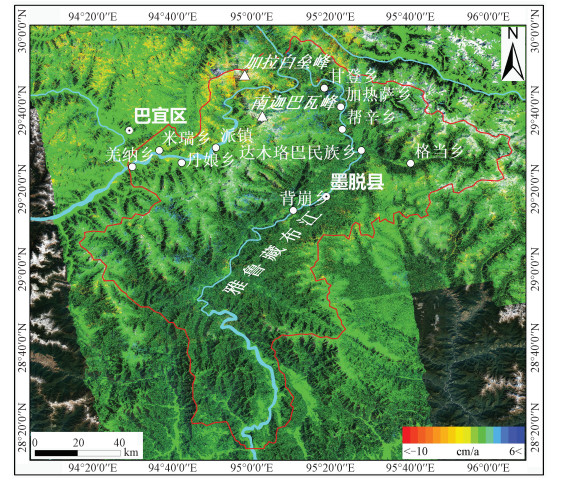
雅鲁藏布江下游位于印度板块和欧亚板块碰撞的前缘地带, 区域内新构造运动活跃, 高山分布众多, 属典型高山深切割区。由于独特的地质构造以及气候变化的影响, 区域内崩塌、滑坡、泥石流等地质灾害频发。文章采用Sentinel-1影像以及ALOS/PALSAR-2影像通过多种时序InSAR技术和SAR偏移量技术联合的方式对区域内2014—2020年高位地质灾害进行了识别。文章研究结果表明: 在研究区内共存在260处地质灾害形变区, 且大多位于海拔较高的沟道与山峰; 泽巴隆巴冰川沟中的岩崩形变体已经形成多条大型拉张裂缝, 一旦发生崩落极有可能形成堰塞湖; 受米林地震影响而复活的达波古滑坡后缘已经完全脱离, 左右两侧裂缝完全贯通, 滑坡一旦失稳会完全堵塞雅鲁藏布江。此研究提供了识别高山峡谷区高位地质灾害的SAR/InSAR技术方法, 为类似的地质灾害识别提供了参考。
Abstract:The lower stream of the Yarlung Zangbo River is in the front zone of the collision between the Indian and Eurasian plates with active neotectonics movements and many high mountains in this region. It is a typical mountain-valley area. Due to the unique geological structure and the influence of climate change, geohazards such as collapses, landslides, and mudslides frequently happen in this area. We used Sentinel-1 and ALOS/PALSAR-2 images to identify the high-elevation geohazards in the region from 2014 to 2020 by combining multiple time-series InSAR techniques and SAR offset-tracking techniques. The identification results show that there are 260 geohazard-induced deformed areas in the study area, and most of them are located in gullies and peaks at higher elevations. The rock avalanche deformations in the Zebalongba glacier gully have formed several large tension cracks, and once the avalanche falls, they are most likely to form a dam. The back edge of the Dabo landslide, which was reactivated by the Milin earthquake, has completely been detached, and the cracks fully penetrate the left and right sides. Once the landslide destabilizes, it will completely block the Yarlung Zangbo River. This study provides a general method for identifying high-elevation geohazards in high mountain-valley areas and a reference for similar geohazards identification.
-
Key words:
- Lower stream of the Yarlung Zangbo River /
- MT-InSAR /
- SAR offset-tracking /
- geohazard
-

-
表 1 所用SAR数据基本参数
Table 1. Fundamental parameters for SAR images used in this study
传感器 波长 飞行方向 数量 覆盖时间 轨道号 Sentinel-1 C 升轨 284 20170316—20200729 143、70、172 ALOS/PALSAR-2 L 升轨 111 20140908—20200507 151、152  下载: 导出CSV
表 2 17处滑坡详细信息
Table 2. Detailed information of 17 landslides
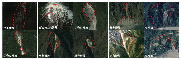
名称 纬度/(°) 经度/(°) 长度/m 宽度/m 1# 29.786468 95.152247 963 371 2# 29.793564 95.149608 355 300 3# 29.796444 95.146486 371 323 4# 29.803274 95.141786 167 180 达波 29.870677 95.148463 1054 1089 巴玉 29.843294 95.240246 2181 460 落古#1 29.774817 95.250962 1151 708 落古#2 29.773159 95.241469 394 597 甘登#1 29.722749 95.302412 1127 565 甘登#2 29.716898 95.293642 702 143 龙列 29.706122 95.341190 462 322 更帮 29.672205 95.351797 799 316 根登 29.602529 95.359356 382 256 帮辛 29.580460 95.372772 179 187 宗荣 29.570525 95.308290 1254 449 #5 28.626808 95.012731 657 793 #6 28.369373 95.065375 594 915 注:表中滑坡的名称基于地名命名,部分未命名原因是由于其分布在无人区;滑坡的长宽基于InSAR测量的形变区域而确定。
下载: 导出CSV
-
BIAN Z X, 2021. Provenance analyses on the Paleogene clastic rocks in Gonjo Basin: implications for Tectonic Evolution[D]. Kunming: Yunnan University. (in Chinese with English abstract)
DAI K R, DENG J, XU Q, et al., 2022. Interpretation and sensitivity analysis of the InSAR line of sight displacements in landslide measurements[J]. GIScience & Remote Sensing, 59(1): 1226-1242.
DUN J W, FENG W K, YI X Y, et al., 2021. Detection and mapping of active landslides before impoundment in the Baihetan Reservoir Area (China) based on the time-series InSAR method[J]. Remote Sensing, 13(16): 3213. doi: 10.3390/rs13163213
GAO P, 2010. Risk assessment and forecast of geological disaster in Southeast Xizang[D]. Beijing: China University of Geosciences (Beijing). (in Chinese with English abstract)
GU Z R, MA C H, ZHANG X Q, et al., 2022. The use of SAR offset tracking for detecting mountain glacier movement[C]//2022 3rd international conference on geology, mapping and remote sensing (ICGMRS). Zhoushan: IEEE: 5-10.
JIANG P, ZHANG Q F, LI S Y, 2022. Hydrochemical evolution in the Yarlung Zangbo River basin[J]. Environmental Science, 1-13 (2022-09-19). https://doi.org/10.13227/j.hjkx.202206297. (in Chinese with English abstract)
KANG Y, 2020. Research on key issues of landslide deformation monitoring and landslide mechanism analysis with InSAR technique[D]. Xi'an: Chang'an University. (in Chinese with English abstract)
KANG Y, LU Z, ZHAO C Y, et al., 2021. InSAR monitoring of creeping landslides in mountainous regions: A case study in Eldorado National Forest, California[J]. Remote Sensing of Environment, 258: 112400. doi: 10.1016/j.rse.2021.112400
LI B, GAO Y, WAN J W, et al., 2020. The chain of the major geological disasters and related strategies in the Yalu-Zangbu River canyon region[J]. Hydropower and Pumped Storage, 6(2): 11-14, 35. (in Chinese with English abstract)
LI J C, 2007. Research on route selection scheme of Lhasa-Rikaze railway in Brahmaputra's Canyon area[J]. Railway Investigation and Surveying, 33(5): 1-6. (in Chinese with English abstract) doi: 10.3969/j.issn.1672-7479.2007.05.001
LI L J, YAO X, ZHOU Z K, et al., 2022. The applicability assessment of Sentinel-1 data in InSAR monitoring of the deformed slopes of reservoir in the mountains of southwest China: A case study in the Xiluodu Reservoir[J]. Journal of Geomechanics, 28(2): 281-293. (in Chinese with English abstract)
LI S W, XU W B, LI Z W, 2022. Review of the SBAS InSAR Time-series algorithms, applications, and challenges[J]. Geodesy and Geodynamics, 13(2): 114-126. doi: 10.1016/j.geog.2021.09.007
LI W H, ZHANG H C, ZHANG H, 2020. InSAR DEM reconstruction method based on StereoSAR[J]. Modern Radar, 42(1): 55-63. (in Chinese with English abstract)
LI X, 2019. Study on the relationship between the development of large landslides and the evolution of neotectonic geomorphology in the Motuhe section of the Yarlung Zangbo River[D]. Chengdu: Chengdu University of Technology. (in Chinese with English abstract)
LIU C Z, LV J T, TONG L Q, et al., 2019. Research on glacial/rock fall-landslide-debris flows in Sedongpu basin along Yarlung Zangbo River in Xizang[J]. Geology in China, 46(2): 219-234. (in Chinese with English abstract)
LIU G X, ZHANG B, ZHANG R, et al., 2019. Monitoring dynamics of Hailuogou glacier and the secondary landslide disasters based on combination of satellite SAR and ground-based SAR[J]. Geomatics and Information Science of Wuhan University, 44(7): 980-995. (in Chinese with English abstract)
LIU L H, WANG A Y, CHEN N S, et al., 2022. The spatial distribution and main controlling factors of collapse-landslides along the downstream of Yalung Zangbo River[J]. Scientific and Technological Innovation, 26(17): 131-134. (in Chinese with English abstract)
LIU X J, ZHAO C Y, ZHANG Q, et al., 2021. Integration of Sentinel-1 and ALOS/PALSAR-2 SAR datasets for mapping active landslides along the Jinsha River corridor, China[J]. Engineering Geology, 284: 106033. doi: 10.1016/j.enggeo.2021.106033
LIU Z, LI B, HE K, et al., 2020. An analysis of dynamic response characteristics of the Yigong Landslide in Xizang under strong earthquake[J]. Journal of Geomechanics, 26(4): 471-480. (in Chinese with English abstract)
MOREIRA A, PRATS-IRAOLA P, YOUNIS M, et al., 2013. A tutorial on synthetic aperture radar[J]. IEEE Geoscience and Remote Sensing Magazine, 1(1): 6-43. doi: 10.1109/MGRS.2013.2248301
OSMANOǦLU B, SUNAR F, WDOWINSKI S, et al., 2016. Time series analysis of InSAR data: Methods and trends[J]. ISPRS Journal of Photogrammetry and Remote Sensing, 115: 90-102. doi: 10.1016/j.isprsjprs.2015.10.003
SHI X G, LIAO M S, LI M H, et al., 2016. Wide-area landslide deformation mapping with multi-path ALOS PALSAR data stacks: a case study of three Gorges Area, China[J]. Remote Sensing, 8(2): 136. doi: 10.3390/rs8020136
SIVALINGAM S, MURUGESAN G P, DHULIPALA K, et al., 2022. Temporal fluctuations of Siachen glacier velocity: a repeat pass SAR interferometry based approach[J]. Geocarto International, 37(17): 4888-4910. doi: 10.1080/10106049.2021.1899306
STROZZI T, WEGMULLER U, WERNER C, et al., 2007. Potential of a C-band SAR mission with 12-day repeat cycle to derive ice surface velocity with interferometry and offset tracking[C]//2007 IEEE international geoscience and remote sensing symposium. Barcelona: IEEE: 4229-4232.
TIZZANI P, BERARDINO P, CASU F, et al., 2007. Surface deformation of Long Valley caldera and Mono Basin, California, investigated with the SBAS-InSAR approach[J]. Remote Sensing of Environment, 108(3): 277-289. doi: 10.1016/j.rse.2006.11.015
WANG J, LIU T C, YI G, 2000. Characteristics of isotope distribution in precipitation in the middle-lower reaches of Yarlung Zangbo River[J]. Earth and Environment, 28(1): 63-67. (in Chinese with English abstract)
WANG X Y, ZHAO C Y, LIU Y Y, et al., 2018. InSAR unwrapping error detection method study based on closed loops[J]. Journal of Geodesy and Geodynamics, 38(3): 321-325. (in Chinese with English abstract)
WANG Y A, DONG J, ZHANG L, et al., 2022. Refined InSAR tropospheric delay correction for wide-area landslide identification and monitoring[J]. Remote Sensing of Environment, 275: 113013. doi: 10.1016/j.rse.2022.113013
XIN C C, 2019. Geomorphology and geological environment effect analysis of the Eastern Structural junction valley of Yarlung Zangbo River based on DEM[D]. Chengdu: Chengdu University of Technology. (in Chinese with English abstract)
YIN Y P, 2000. Rapid huge landslide and hazard reduction of Yigong River in the Bomi, Xizang[J]. Hydrogeology & Engineering Geology, 44(4): 8-11. (in Chinese with English abstract)
YUAN Z, LI Y, YANG Z Y, et al., 2014. Spatio-temporal variation characteristics of extreme precipitation events in Xizang in last 50 Years[J]. Water Resources and Hydropower Engineering, 45(10): 19-23, 27. (in Chinese with English abstract)
ZHAI Y F, 2022. The distribution and scale and outbreak frequency characteristics of glacial debris flow in southeast Xizang[D]. Lhasa: Xizang University. (in Chinese with English abstract)
ZHANG P Q, LIU X H, 2008. Debris flow distribution and preventions at the great turning in the gorge of Yarlung Zangbo River, southeastern Xizang[J]. The Chinese Journal of Geological Hazard and Control, 19(1): 12-17. (in Chinese with English abstract)
ZHAO D Z, QU C Y, CHEN H, et al., 2021. Tectonic and geometric control on fault kinematics of the 2021 MW7.3 Maduo (China) earthquake inferred from interseismic, coseismic, and postseismic InSAR observations[J]. Geophysical Research Letters, 48(18): e2021GL09541712.
ZHU S, 2012. River landform and geology environment evolution in the Yarlung Zangbo River valley[D]. Beijing: Chinese Academy of Geological Sciences. (in Chinese with English abstract)
ZHU Y F, YAO X, YAO L H, et al., 2022. Identification and risk assessment of coal mining-induced landslides in Guizhou Province by InSAR and optical remote sensing[J]. Journal of Geomechanics, 28(2): 268-280. (in Chinese with English abstract)
边紫璇, 2021. 藏东南贡觉盆地古近系碎屑岩物源示踪及其构造意义[D]. 昆明: 云南大学.
高鹏, 2010. 藏东南地质灾害危险性评估及预测[D]. 北京: 中国地质大学(北京).
江平, 张全发, 李思悦, 2022. 雅鲁藏布江水化学演变规律[J]. 环境科学, 1-13 (2022-09-19). 鲁藏布江水化学演变规.
康亚, 2020. 滑坡形变InSAR监测关键技术研究与机理分析[D]. 西安: 长安大学.
李滨, 高杨, 万佳威, 等, 2020. 雅鲁藏布江大峡谷地区特大地质灾害链发育现状及对策[J]. 水电与抽水蓄能, 6(2): 11-14, 35. https://www.cnki.com.cn/Article/CJFDTOTAL-DBGC202002003.htm
李金城, 2007. 拉日铁路雅鲁藏布江峡谷区线路方案比选研究[J]. 铁道勘察, 33(5): 1-6. https://www.cnki.com.cn/Article/CJFDTOTAL-TLHC200705002.htm
李凌婧, 姚鑫, 周振凯, 等, 2022. Sentinel-1数据在西南山区水库变形斜坡InSAR监测中的适用性评价: 以溪洛渡水库为例[J]. 地质力学学报, 28(2): 281-293. https://journal.geomech.ac.cn/cn/article/doi/10.12090/j.issn.1006-6616.2021109
李伟华, 张华春, 张衡, 2020. 基于StereoSAR辅助的InSAR DEM重建方法研究[J]. 现代雷达, 42(1): 55-63. https://www.cnki.com.cn/Article/CJFDTOTAL-XDLD202001012.htm
李翔, 2019. 雅鲁藏布江墨脱河段大型滑坡发育与新构造地貌演化关联性研究[D]. 成都: 成都理工大学.
刘传正, 吕杰堂, 童立强, 等, 2019. 雅鲁藏布江色东普沟崩滑-碎屑流堵江灾害初步研究[J]. 中国地质, 46(2): 219-234. https://www.cnki.com.cn/Article/CJFDTOTAL-DIZI201902002.htm
刘国祥, 张波, 张瑞, 等, 2019. 联合卫星SAR和地基SAR的海螺沟冰川动态变化及次生滑坡灾害监测[J]. 武汉大学学报·信息科学版, 44(7): 980-995. https://www.cnki.com.cn/Article/CJFDTOTAL-WHCH201907004.htm
刘丽红, 王翱宇, 陈宁生, 等, 2022. 雅鲁藏布江下游沿河段滑坡崩塌空间分布特征及其主控因素[J]. 科学技术创新, 26(17): 131-134. https://www.cnki.com.cn/Article/CJFDTOTAL-HLKX202217032.htm
刘铮, 李滨, 贺凯, 等, 2020. 地震作用下西藏易贡滑坡动力响应特征分析[J]. 地质力学学报, 26(4): 471-480. https://journal.geomech.ac.cn/cn/article/doi/10.12090/j.issn.1006-6616.2020.26.04.040
王军, 刘天仇, 尹观, 2000. 西藏雅鲁藏布江中、下游地区大气降水同位素分布特征[J]. 地质地球化学, 28(1): 63-67. https://www.cnki.com.cn/Article/CJFDTOTAL-DZDQ200001010.htm
王霞迎, 赵超英, 刘媛媛, 等, 2018. 基于闭合环的InSAR解缠误差探测方法研究[J]. 大地测量与地球动力学, 38(3): 321-325. https://www.cnki.com.cn/Article/CJFDTOTAL-DKXB201803020.htm
辛聪聪, 2019. 基于DEM雅鲁藏布江东构造结河谷地貌及其地质环境效应研究[D]. 成都: 成都理工大学.
殷跃平, 2000. 西藏波密易贡高速巨型滑坡特征及减灾研究[J]. 水文地质工程地质, 27(4): 8-11. https://www.cnki.com.cn/Article/CJFDTOTAL-SWDG200004002.htm
袁喆, 李艳, 杨志勇, 等, 2014. 近50年来西藏极端降水时空变化特征[J]. 水利水电技术, 45(10): 19-23, 27. https://www.cnki.com.cn/Article/CJFDTOTAL-SJWJ201410008.htm
翟毅飞, 2022. 藏东南地区冰川泥石流分布规律与规模频率特征研究[D]. 拉萨: 西藏大学.
张沛全, 刘小汉, 2008. 雅鲁藏布江大拐弯入口段泥石流特征及应对措施[J]. 中国地质灾害与防治学报, 19(1): 12-17. https://www.cnki.com.cn/Article/CJFDTOTAL-ZGDH200801004.htm
祝嵩, 2012. 雅鲁藏布江河谷地貌与地质环境演化[D]. 北京: 中国地质科学院.
朱怡飞, 姚鑫, 姚磊华, 等, 2022. 基于InSAR和光学遥感的贵州鬃岭采煤滑坡识别与危险性评价[J]. 地质力学学报, 28(2): 268-280. https://journal.geomech.ac.cn/cn/article/doi/10.12090/j.issn.1006-6616.2021054
-

图(15)
表(2)
计量
- 文章访问数: 2156
- PDF下载数: 124
- 施引文献: 0