Stratigraphy and chronology of a Late Pleistocene sediment core from Hasuhai Lake in Inner Mongolia
-
摘要:
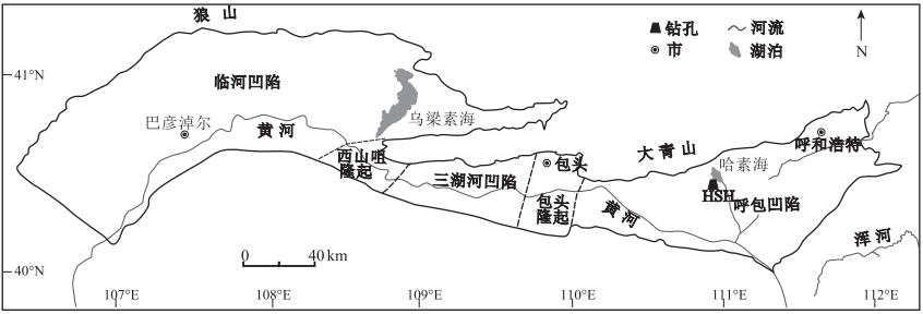
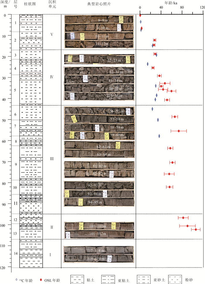
“河套古大湖”对于研究区域环境及气候演化具有重要的意义,然而,其形成与消亡的时代仍存在争议。依托于哈素海西南岸边获取的HSH钻孔,采用AMS14C、OSL测年方法确定了沉积物年代,结合岩心的岩性、沉积结构等特征,分析了哈素海的演化历史,并探讨了河套古大湖存亡的时期。结果表明,哈素海地区晚更新世以来的沉积环境主要经历了以下转变过程:150~70 ka为较稳定的湖泊,70~55 ka湖泊水位下降,为滨湖相沉积,55~27 ka为湖沼沉积,27~0 ka为滨湖相沉积。根据哈素海的沉积演化历史,结合河套盆地相关研究成果,认为河套古大湖早在150~110 ka就已形成,其后水位下降,直至55 ka之后,萎缩消亡,河套盆地局部地区形成湖沼沉积,但已不再是统一的大湖。研究结果对于深入探讨河套盆地演化历史乃至黄河的变迁具有重要意义。
Abstract:The "mega-paleolake" in Hetao Basin has great significance for the study of the evolution of the local environment and climate, but its time of the formation and disappearance remains controversial.Based on the HSH drilling data obtained from the southwest coast of Hasuhai lake, the ages of the sediments were determined by AMS 14C and OSL dating methods.Combined with the zharacteristies of lithology and sedimentary structure, the evolution history of Hasuhai lake was analyzed, and the survival period of Hetao ancient lake was discussed.The results show that the sedimentary environment in the Hasuhai Lake area has undergone the following transformation since the Late Pleistocene.It was a relatively stable lake during 150~70 ka, and transformed into lakeside facies in 70~55 ka due to the decrease of the water level.It turned into swamp in 55~27 ka, and transformed into lakeside facies again during 27~0 ka with the rise of the water level.According to this study, combined with the other research results, it is believed that the "mega-paleolake"in Hetao Basin was formed as early as 150~110 ka.It shrank and even died out during 110~55 ka.After that, although some regions in Hetao Basin were lake or swamp, it was no longer a unified mega-lake.The result is significant for the further study of the environmental changes in Hetao Basin.
-
Key words:
- Hasuhai Lake /
- Late Pleistocene /
- OSL dating /
- AMS 14C dating /
- the Yellow River /
- Inner Mongolia /
- geological survey engineering
-

-
表 1 HSH钻孔岩性特征
Table 1. Lithology of the HSH borehole
层号 孔深/m 层厚/m 岩性描述 1 8.25 8.25 浅棕色亚粘土,夹2层灰黄色粉砂层(0.65~1.6 m,3.6~4.9 m)。亚粘土结构致密,块状构造,稍有光泽,见水平层理,局部见有机质含量较高的夹层,呈灰黑色;粉砂层较为疏松,水平层理明显。0~0.2 m为耕作层,岩性为灰黄色亚砂土,可见植物根系 2 16.9 8.65 灰黄色亚砂土与灰黄色粉砂互层,亚砂土结构较疏松,块状构造,断面粗糙,夹灰黑色有机质薄层,局部见带状、灰绿色锈染,呈斑块状;粉砂层含水量较大,局部含泥较高,具有水平层理,与下伏地层接触界线清晰 3 21.3 4.4 深灰色淤泥质亚砂土,结构较疏松,有机质含量较高,有明显臭味,块状构造,断面粗糙,底部可见大量螺类化石碎片 4 29.6 8.3 灰黄色亚砂土,夹薄层灰黄色粉砂、亚粘土层。亚砂土层结构疏松,块状构造,断面粗糙,可嗅臭味,局部见斜层理、波状层理、交错层理、水平层理,局部可见红色氧化带薄层。粉砂层结构疏松。亚粘土层结构致密,局部可见灰绿色锈染 5 43.2 13.6 灰色、深灰色亚砂土,结构疏松,块状构造,可嗅臭味,含红色、棕红色、黄褐色氧化团块,可见水平层理、波状层理,局部见直径3~5 mm的螺类化石及其碎片。夹灰黄色、灰色致密亚粘土薄层 6 50.1 6.9 灰色、浅灰色亚砂土,结构疏松,局部见粉砂薄层、致密块状有机质含量高的亚粘土层。该层顶部见红色氧化薄层,底部见螺类化石碎片 7 57.8 7.7 粉砂与亚砂土互层,有机质含量高,上部深灰色,向下颜色较浅为灰色、黄灰色,局部可见水平层理、斜层理、波状层理。粉砂疏松,顶部含泥量较高。亚砂土结构疏松,块状构造,断面粗糙。底部为灰色亚粘土 8 62.35 4.55 黄灰色粉砂,疏松,以石英长石为主要成分,分选性、磨圆度好,夹黄灰色亚砂土薄层,局部见薄层浅红色氧化条带 9 78.5 16.2 亚粘土,结构致密,块状构造,稍有光泽,顶部为黄灰色,向下颜色渐变为灰色、深灰色,可见微细的水平层理、微斜层理。底部为浅灰色疏松粉砂薄层(约0.8 m) 10 85.3 6.8 灰黄、浅黄棕色亚粘土,结构致密,块状构造,稍有光泽 11 94.8 9.5 灰色、灰黄色粉砂,松散,以石英长石为主要成分,分选性、磨圆度好,局部可见条带状锈染。该层顶部见斜层理,86.6~86.8 m处有红色氧化条带,可见波状层理,下部含砂(中粗砂)量较高,含有炭化碎屑,偶见螺类化石碎片 12 99.5 4.7 灰黄色粉砂,松散,以石英长石为主要成分,分选磨圆好。见黄棕色亚粘土薄层,且中部有机质含量较高,局部颜色较深 13 107.5 8 亚粘土与粉砂互层,亚粘土呈灰黄色、深黄色,结构致密,见亚砂土薄层,轻微水平层理,局部有机质含量高。粉砂为灰黄色、灰色,结构疏松,与下伏地层接触关系明显 14 121.3 13.8 亚粘土、粘土,结构致密,块状构造,稍有光泽,上部为浅棕色,向下颜色过渡到黄棕色、深灰色。顶部发育轻微水平层理 表 2 等效剂量恢复结果
Table 2. Results of dose recovery test
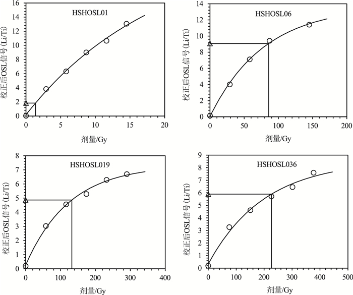
样品号 附加等效剂量/Gy 测得等效剂量/Gy 剂量恢复率/% HSHOSL11 50 52.9±4.8 105.8 HSHOSL11 100 93.9±8.1 93.9 HSHOSL29 150 154.4±14.2 102.9 HSHOSL29 250 229.3±23.2 91.7 表 3 HSH钻孔样品OSL测年结果
Table 3. OSL dating results of samples from the borehole HSH
样品号 深度/m U /10-6 Th /10-6 K /% 含水量/% 环境剂量率D/(Gy·ka-1) 等效剂量De/Gy 年代/ka HSHOSL01 0.4 2.7±0.11 11.8±0.33 2.22±0.06 35±10 3.34±0.23 1.38±0.31 0.4±0.1 HSHOSL03 6.6 3.3±0.13 13.8±0.37 2.4±0.07 25±10 3.96±0.3 12.09±1.24 3.1±0.4 HSHOSL06 12.23 3.18±0.12 9.84±0.3 1.78±0.06 25±10 3.09±0.24 85.77±2.88 27.8±2.4 HSHOSL07 14.55 2.33±0.1 10.1±0.32 1.72±0.06 35±10 2.58±0.19 68.68±2.61 26.6±2.2 HSHOSL08 18.8 2.01±0.08 9.2±0.28 1.8±0.06 25±10 2.71±0.21 78.07±5.14 28.8±2.9 HSHOSL11 25.4 2.86±0.11 9.16±0.27 1.83±0.06 25±10 2.95±0.23 72.31±4.93 24.5±2.5 HSHOSL13 29.2 1.95±0.08 11.2±0.31 2.1±0.06 30±10 2.93±0.22 107.98±7.82 36.9±3.8 HSHOSL14 32.8 1.88±0.08 10.3±0.3 2.04±0.06 25±10 2.92±0.22 138.29±26.96 47.3±9.9 HSHOSL15 35.7 2.19±0.09 10.7±0.31 1.75±0.06 25±10 2.81±0.22 123.55±23.19 44±8.9 HSHOSL16 34.18 2.3±0.09 10.3±0.3 1.95±0.06 25±10 2.97±0.23 119.25±5.43 40.2±3.6 HSHOSL17 36.5 1.95±0.08 10.7±0.31 2.06±0.06 25±10 2.99±0.23 178.74±21.02 59.8±8.4 HSHOSL19 40.7 2.15±0.09 7.8±0.25 1.75±0.06 25±10 2.57±0.2 132.31±7.13 51.5±4.8 HSHOSL21 48.7 2.36±0.09 13.1±0.37 2.43±0.07 25±10 3.57±0.28 236.31±7.86 66.2±5.6 HSHOSL22 55.5 2.33±0.09 13.4±0.36 2.6±0.07 25±10 3.71±0.28 273.63±51.4 73.7±14.9 HSHOSL25 63.7 2.85±0.11 12.8±0.36 2.06±0.06 20±10 3.55±0.29 204.57±6.97 57.6±5.1 HSHOSL27 70.5 2.1±0.09 10.3±0.3 1.83±0.06 20±10 2.95±0.24 181.65±4.69 61.7±5.2 HSHOSL29 75.95 2.12±0.09 10.1±0.29 2.08±0.06 20±10 3.14±0.25 174.44±26.59 55.6±9.5 HSHOSL31 82.15 2.4±0.1 11.4±0.32 2.16±0.06 20±10 3.39±0.27 190.74±14.61 56.3±6.2 HSHOSL36 96.8 2.05±0.09 8.63±0.27 1.95±0.06 25±10 2.76±0.21 226.37±19.95 82.2±9.6 HSHOSL37 100.7 2.57±0.1 9.5±0.28 2±0.06 25±10 3±0.23 271.11±39.99 90.3±15 HSHOSL38 102.4 3.02±0.12 10±0.29 2.07±0.06 30±10 3.07±0.23 326.1±7.6 106.1±8.4 表 4 HSH钻孔样品AMS 14C测年结果
Table 4. AMS 14C dating results of samples from the borehole HSH
实验室编号 样品编号 取样深度/m δ13C/‰ 误差(1σ) pMC/% 误差(1σ) 14C年龄/a B.P. 误差(1σ) 校正后日历年龄/cal.a B.P. (2σ,95.4%) XA20032 HSH002 3.5 -25.7 0.49 83.64 0.26 1.435 25 1363~1296 XA20033 HSH004 7.4 -25.83 0.44 77.62 0.23 2.035 25 2052~1890 XA20034 HSH005 14.9 -25.74 0.38 8.48 0.07 19.825 70 24070~23740 XA20035 HSH006 19.3 -23.22 0.38 3.31 0.04 27.37 110 31619~31146 XA20036 HSH008 23.6 -24.78 0.36 21.31 0.11 12.42 40 14885~14276 XA20037 HSH009 34 -25.35 0.4 4.1 0.05 25.655 95 30129~29831 XA20038 HSH010 38.5 -25.07 0.31 3.13 0.05 27.815 140 32052~31332 XA20039 HSH011 40.5 -25.23 0.47 4.47 0.05 24.96 95 29493~28881 XA20040 HSH012 45 -26.68 0.39 8.8 0.07 19.53 65 23781~23301 XA20041 HSH013 50.2 -23.28 0.42 2.5 0.04 29.625 120 34448~33912 XA20042 HSH015 57.9 -27.31 0.32 1.79 0.03 32.315 160 36995~36260 -
[1] 陈发虎, 范育新, 春喜, 等. 晚第四纪"吉兰泰-河套"古大湖的初步研究[J]. 科学通报, 2008, 53(10): 1207-1219. doi: 10.3321/j.issn:0023-074X.2008.10.013
[2] Li G Q, Jin M, Chen X M, et al. Environmental changes in the Ulan Buh Desert, southern Inner Mongolia, China since the middle Pleistocene based on sedimentology, chronology and proxy indexes[J]. Quaternary Science Reviews, 2015, 128: 69-80. doi: 10.1016/j.quascirev.2015.09.010
[3] 马保起, 李德文, 郭文生. 晚更新世晚期呼包盆地环境演化与地貌响应[J]. 第四纪研究, 2004, 24(6): 630-637. doi: 10.3321/j.issn:1001-7410.2004.06.004
[4] 梁阿如娜. 晚第四纪包头盆地古湖演化与环境变迁[D]. 内蒙古师范大学硕士学位论文, 2011.
[5] Yang X C, Cai M T, Hu J M, et al. The paleolake hydrology and climate change since the ~40 ka in the Hetao Basin, Inner Mongolia, China[J]. Quaternary International, 2020, 553: 73-82. doi: 10.1016/j.quaint.2020.06.040
[6] 李建彪, 冉勇康, 郭文生. 河套盆地托克托台地湖相层研究[J]. 第四纪研究, 2005, 25(5): 630-639. doi: 10.3321/j.issn:1001-7410.2005.05.012
[7] 陈发虎, 范育新, Madsen D B, 等. 河套地区新生代湖泊演化与"吉兰泰-河套"古大湖形成机制的初步研究[J]. 第四纪研究, 2008, 28(5): 866-873. doi: 10.3321/j.issn:1001-7410.2008.05.009
[8] Yang X C, Cai M T, Ye P S, et al. Late Pleistocene paleolake evolution in the Hetao Basin, Inner Mongolia, China[J]. Quaternary International, 2018, 464: 386-395. doi: 10.1016/j.quaint.2017.11.047
[9] Duller G A T. Distinguishing quartz and feldspar in single grain luminescence measurements[J]. Radiation Measurements, 2003, 37(2): 161-165. doi: 10.1016/S1350-4487(02)00170-1
[10] 王旭龙, 卢演俦, 李晓妮. 细颗粒石英光释光测年: 简单多片再生法[J]. 地震地质, 2005, 27(4): 615-623. doi: 10.3969/j.issn.0253-4967.2005.04.010
[11] Adamiec G, Aitken M. Dose-rate conversion factors: update[J]. Ancient TL, 1998, 16(2): 37-50.
[12] Prescott J R, Hutton J T. Cosmic ray contributions to dose rates for luminescence and ESR dating: Large depths and long-term time variations[J]. Radiation Measurements, 1994, 23(2): 497-500.
[13] Aitken M J, Xie J. Moisture Correction for Annual Gamma Dose[J]. Ancient TL, 1990, 8(2): 6-9.
[14] Durcan J A, King G E, Duller G A T. DRAC: Dose Rate and Age Calculator for trapped charge dating[J]. Quaternary Geochronology, 2015, 28: 54-61. doi: 10.1016/j.quageo.2015.03.012
[15] Heaton T J, Blaauw M, Blackwell P G, et al. The Intcal 20 Approach to Radiocarbon Calibration Curve Construction: A New Methodology Using Bayesian Splines and Errors-In-Variables[J]. Radiocarbon, 2020, 62(4): 1-43.
[16] 赵华, 卢演俦, 王成敏, 等. 水成沉积物释光测年研究进展与展望[J]. 核技术, 2011, 34(2): 82-86. https://www.cnki.com.cn/Article/CJFDTOTAL-HJSU201102002.htm
[17] Smedley R K, Skirrow G K A. Luminescence Dating in Fluvial Settings: Overcoming the Challenge of Partial Bleaching[Z]. 2020.
[18] Lang A, Zolitschka B. Optical dating of annually laminated lake sediments A test case from Holzmaar/Germany[J]. Quaternary Science Reviews, 2001, 20(5): 737-742.
[19] Hu G, Zhang J F, Qiu W L, et al. Residual OSL signals in modern fluvial sediments from the Yellow River (HuangHe) and the implications for dating young sediments[J]. Quaternary Geochronology, 2010, 5(2/3): 187-193.
[20] He Z, Long H, Yang L H, et al. Luminescence dating of a fluvial sequence using different grain size fractions and implications on Holocene flooding activities in Weihe Basin, central China[J]. Quaternary Geochronology, 2019, 49: 123-130. doi: 10.1016/j.quageo.2018.05.007
[21] Zhang J F, Qiu W L, Wang X Q, et al. Optical dating of a hyperconcentrated flow deposit on a Yellow River terrace in Hukou, Shaanxi, China[J]. Quaternary Geochronology, 2010, 5: 194-199. doi: 10.1016/j.quageo.2009.05.001
[22] 张家富, 袁宝印, 周力平. 福建晋江"老红砂"的释光年代学及对南方第四纪沉积物释光测年的指示意义[J]. 科学通报, 2007, 52(22): 2646-2654. doi: 10.3321/j.issn:0023-074x.2007.22.011
[23] Zimmerman D W. Thermoluminescent dating using fine grains from pottery[J]. Archaeometry, 1971, 13(1): 29-52. doi: 10.1111/j.1475-4754.1971.tb00028.x
[24] 张家富, 周力平, 姚书春, 等. 湖泊沉积物的14C和光释光测年——以固城湖为例[J]. 第四纪研究, 2007, 27(4): 522-528. doi: 10.3321/j.issn:1001-7410.2007.04.007
[25] 程鹏, 卢雪峰, 杜花, 等. 青海湖老碳效应的时空变化初步研究[J]. 地球环境学报, 2016, 7(4): 357-365. https://www.cnki.com.cn/Article/CJFDTOTAL-DQHJ201604004.htm
[26] 吴艳宏, 王苏民, 周力平, 等. 岱海14C测年的现代碳库效应研究[J]. 第四纪研究, 2007, 27(4): 507-510. doi: 10.3321/j.issn:1001-7410.2007.04.005
[27] Song Y G, Lai Z P, Li Y, et al. Comparison between luminescence and radiocarbon dating of late Quaternary loess from the Ili Basin in Central Asia[J]. Quaternary Geochronology, 2015, 30: 405-410. doi: 10.1016/j.quageo.2015.01.012
[28] Long H, Shen J, Wang Y, et al. High-resolution OSL dating of a late Quaternary sequence from Xingkai Lake (NE Asia): Chronological challenge of the "MIS 3a Mega-paleolake" hypothesis in China[J]. Earth and Planetary Science Letters, 2015, 428: 281-292. doi: 10.1016/j.epsl.2015.07.003
[29] 闵隆瑞, 朱关祥, 关友义. 内蒙古萨拉乌苏河流域第四系更新统上部萨拉乌苏阶基本特征剖析[J]. 中国地质, 2009, 36(6): 1208-1217. doi: 10.3969/j.issn.1000-3657.2009.06.002
[30] 邓金宪, 刘正宏, 徐仲元, 等. 包头地区晚更新世—全新世地层划分对比及环境变迁[J]. 地层学杂志, 2007, 31(2): 133-140. doi: 10.3969/j.issn.0253-4959.2007.02.005
[31] 毕志伟, 杨振京, 王利康, 等. 临河凹陷QK3钻孔220 ka以来的沉积环境演变记录[J]. 科学技术与工程, 2021, 21(22): 9229-9235. doi: 10.3969/j.issn.1671-1815.2021.22.007
[32] 赵红梅, 赵华, 刘林敬, 等. 包头地区晚第四纪沉积地层与环境演化[J]. 干旱区资源与环境, 2016, 30(4): 165-171. https://www.cnki.com.cn/Article/CJFDTOTAL-GHZH201604028.htm
[33] 杨利荣, 邹宁, 岳乐平, 等. 库布齐沙漠碎屑锆石U-Pb年龄组成及其物源分析[J]. 第四纪研究, 2017, 37(3): 560-569. https://cdmd.cnki.com.cn/Article/CDMD-10697-1017104548.htm
[34] Jia L Y, Zhang X J, He Z X, et al. Late Quaternary climatic and tectonic mechanisms driving river terrace development in an area of mountain uplift: A case study in the Langshan area, Inner Mongolia, northern China[J]. Geomorphology, 2015, 234: 109-121. doi: 10.1016/j.geomorph.2014.12.043
[35] 李建彪, 冉勇康, 郭文生. 呼包盆地第四纪地层与环境演化[J]. 第四纪研究, 2007, 27(4): 632-644. doi: 10.3321/j.issn:1001-7410.2007.04.020
[36] 杨星辰, 叶培盛, 蔡茂堂, 等. 150ka以来内蒙古河套古大湖沉积物粒度记录的湖泊水位变化[J]. 地质通报, 2017, 36(6): 1043-1050. doi: 10.3969/j.issn.1671-2552.2017.06.016 http://dzhtb.cgs.cn/gbc/ch/reader/view_abstract.aspx?file_no=20170616&flag=1
[37] Wei G X, Rao Z G, Dong J, et al. Late Quaternary climatic influences on megalake Jilantai-Hetao, North China, inferred from a water balance model[J]. Journal of Paleolimnology, 2016, 55(3): 223-240. doi: 10.1007/s10933-015-9876-9
[38] 赵希涛, 贾丽云, 胡道功. 内蒙河套地区黄河阶地与新近纪砾石层的发现及其对黄河发育、中国河流古老性与河湖共存论的意义[J]. 地质学报, 2018, 92(4): 845-886. doi: 10.3969/j.issn.0001-5717.2018.04.013
[39] 傅建利, 张珂, 马占武, 等. 中更新世晚期以来高阶地发育与中游黄河贯通[J]. 地学前缘, 2013, 20(4): 166-181. https://www.cnki.com.cn/Article/CJFDTOTAL-DXQY201304016.htm
[40] Fan Y X, Mou X S, Wang Y D, et al. Quaternary paleoenvironmental evolution of the Tengger Desert and its implications for the provenance of the loess of the Chinese Loess Plateau[J]. Quaternary Science Reviews, 2018, 197: 21-34. doi: 10.1016/j.quascirev.2018.08.002
[41] Fan Y X, Wang Y D, Mou X S, et al. Environmental status of the Jilantai Basin, North China, on the northwestern margin of the modern Asian summer monsoon domain during Marine Isotope Stage 3[J]. Journal of Asian Earth Sciences, 2017, 147: 178-192. doi: 10.1016/j.jseaes.2017.07.012
[42] Jia L Y, Zhang X J, Ye P S, et al. Development of the alluvial and lacustrine terraces on the northern margin of the Hetao Basin, Inner Mongolia, China: Implications for the evolution of the Yellow River in the Hetao area since the late Pleistocene[J]. Geomorphology, 2016, 263: 87-98. doi: 10.1016/j.geomorph.2016.03.034
-


 下载:
下载:

