

Effect of geological mapping in shallow overburden area of East Junggar, Xinjiang Province: A case of bedrock geological mapping in the Dure shallow overburden area
-
摘要:
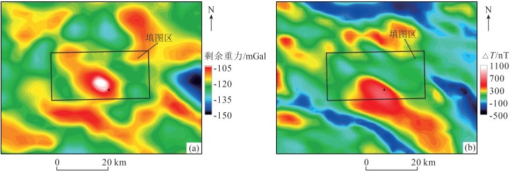
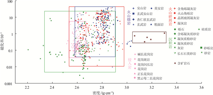
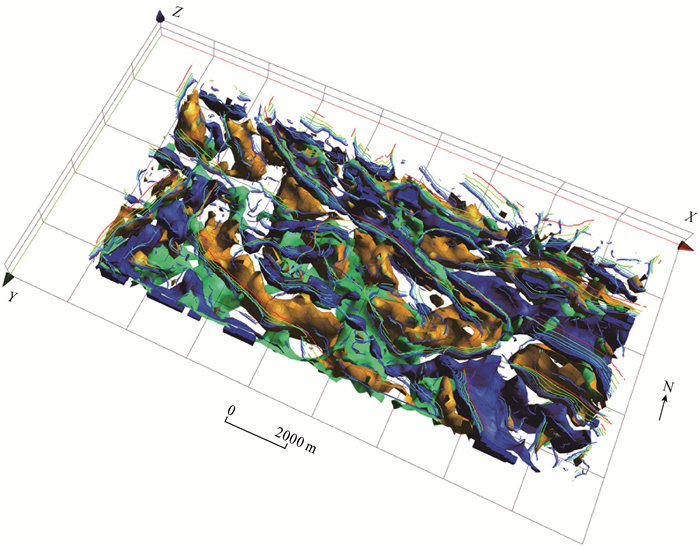
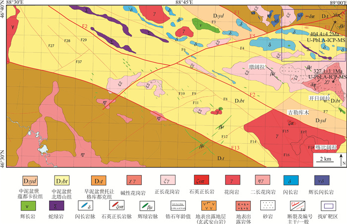
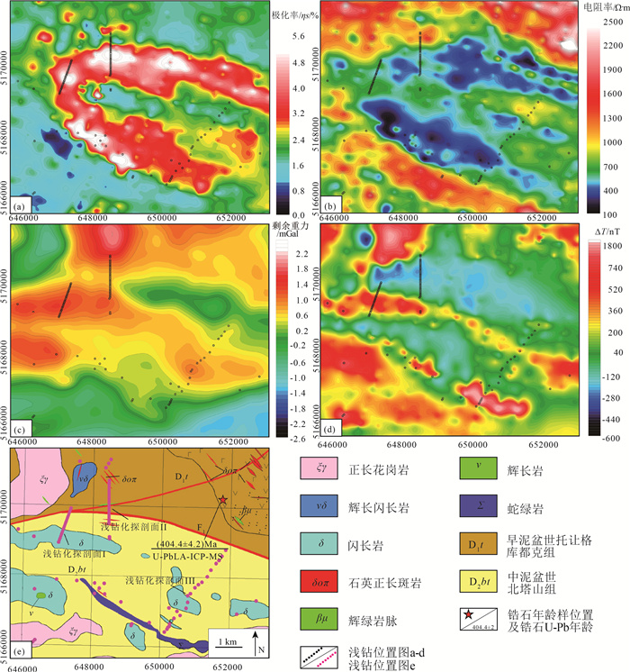
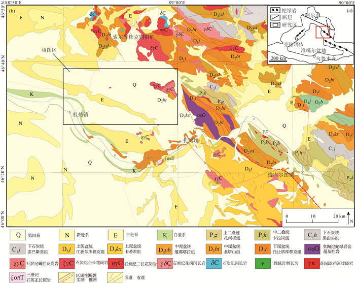
如何“剥离”盖层,以获取盖层下伏基岩地质(地层、岩浆岩、构造)及矿化信息是开展成矿带浅覆盖区地质填图的重要研究内容。结合区域地质及地球物理场特征,梳理了填图区与基岩地质填图有关问题,在填图区岩石物性分析的基础上,通过对1:5万重力、磁力和激电(IP)测量数据处理分析,采用多参数互约束解释技术和钻探验证约束技术“剥离”盖层,进而获得杜热一带覆盖区下伏基岩地质图,并提出以“穿透性”地球物理探测技术(重磁电)为先导,融合地质、地球化学、浅钻为一体的综合调查技术。在填图区新识别隐伏岩体43处(包括中酸性岩体18处,中基性岩体21处, 基性—超基性岩体4处),划分主要断裂构造22条,进而划分出阿尔曼太-扎河坝蛇绿混杂岩带、北部萨吾尔—二台古生代复合岛弧带和南部谢米斯台-库兰喀孜干古生代复合岛弧带3个三级地质构造分区;划分出奥依达格-吉勒库木铜金钴、铬铁矿找矿远景区1处,圈定找矿靶区4处,其中位于阿尔曼太-扎河坝蛇绿混杂岩带西延带的浅覆盖区玉塔斯铜金钴找矿靶区具有很好的找矿潜力。通过地球物理解译和钻探验证,成功预测并新发现准格尔北缘盆山结合带扎河坝-阿尔曼太蛇绿混杂岩带向西部浅覆盖区延伸。杜热一带浅覆盖区基岩地质填图效果表明,开展成矿带浅覆盖区基岩地质填图可为区域构造环境、成矿地质背景研究和找矿靶区预测提供重要基础地质和矿化蚀变信息。
Abstract:How to "peel off " the cover to obtain the underlying bedrock geology (strata, magmatic rock and structure)and mineralization information is an important research content of geological mapping in shallow overburden area of metallogenic belt.Combined with the characteristics of regional geology and geophysical field, the problems related to the mapping area and bedrock geological mapping were sorted out.Based on the physical property analysis of the mapping area, through the processing and analysis of 1:50000 gravity, magnetic and IP measurement data, the multi-parameter mutual constraint interpretation technique and drilling verification were used to peel off the overburden, and then the underlying bedrock geological map of the Dure overburden area was obtained.Meanwhile, a comprehensive investigation technology guided by "penetrating" geophysical technology (gravity, magnetism, and electricity), integrating geology, geochemistry and shallow drilling was proposed.In this paper, 43 concealed plutons and 22 faults in the mapping area were recognized, including 18 intermediate-acid plutons, 21 medium-basic plutons and 4 basic-ultrabasic plutons.Three 3-order geological tectonic zones were divided, namely Aermantai-Zhahaba ophilitic melange belt, Sawur-Ertai Paleozoic composite island arc belt in the north, and Xiemistai-Kulankazigan Paleozoic composite island arc belt in the south.The Aoyidage-Jilekumu Cu-Au-Co-Fe prospect was determined, in which 4 ore prospects were delineated.Among ore prospects, the Yutasi Cu-Au-Co target area in the west of Aermantai-Zhahaba ophilitic melange belts exhibits agreeable prospecting potential.Through geophysical interpretation and drilling verification, it was successfully predicted and confirmed that the Aermantai-Zhahaba ophilitic melange belt on the basin-mountain junction belt in the northern margin of Jungar extends to the shallow coverage area in the west.The geological mapping of batholith in the Dure shallow coverage area can provide the important basic geological and mineralized alteration information for the regional tectonic environment, metallogenic geological backgrounds and predictions of ore prospects.
-

-
[1] 吕庆田, 孟贵祥, 严加永, 等. 成矿系统的多尺度探测: 概念与进展——以长江中下游成矿带为例[J]. 中国地质, 2019, 46(4): 673-689. https://www.cnki.com.cn/Article/CJFDTOTAL-DIZI201904002.htm
[2] 施俊法, 唐金荣, 周平, 等. 隐伏矿勘查经验与启示——从《信息找矿战略与勘查百例》谈起[J]. 地质通报, 2008, 27(4): 433-450. doi: 10.3969/j.issn.1671-2552.2008.04.001 http://dzhtb.cgs.cn/gbc/ch/reader/view_abstract.aspx?file_no=20080401&flag=1
[3] 孟贵祥, 吕庆田, 严加永, 等. "穿透性"探测技术在覆盖区地质矿产调查中的应用研究[J]. 地球学报, 2019, 40(5): 637-650. https://www.cnki.com.cn/Article/CJFDTOTAL-DQXB201905001.htm
[4] 胡健民. 特殊地区地质填图工程概况[J]. 地质力学学报, 2016, 22(4): 803-808. doi: 10.3969/j.issn.1006-6616.2016.04.001
[5] 王国灿, 赵璇, 陈超, 等. 西北断陷盆地覆盖区填图方法探索——新疆巴里坤盆地填图实践[J]. 地质力学学报, 2016, 22(4): 809-821. doi: 10.3969/j.issn.1006-6616.2016.04.002
[6] 孟昭君, 阚学胜, 李宪臣, 等. 大兴安岭北东段森林覆盖区岔路口巨型斑岩钼多金属矿床的发现过程及意义[J]. 中国地质, 2011, 38(6): 433-450. https://www.cnki.com.cn/Article/CJFDTOTAL-DIZI201106012.htm
[7] 成秋明. 覆盖区矿产综合预测思路与方法[J]. 地球科学-中国地质大学学报, 2012, 37(6): 1109-1125. https://www.cnki.com.cn/Article/CJFDTOTAL-DQKX201206005.htm
[8] 严加永, 吕庆田, 陈向斌, 等. 基于重磁反演的三维岩性填图试验-以安徽庐枞矿集区为例[J]. 岩石学报, 2014, 30(4): 1041-1053. https://www.cnki.com.cn/Article/CJFDTOTAL-YSXB201404012.htm
[9] 汪青松. 安徽省淮北前常-徐楼覆盖区综合找矿方法研究[J]. 安徽地质, 2010, 20(3): 206-212. doi: 10.3969/j.issn.1005-6157.2010.03.011
[10] 陈超, 许顺芳, 王国灿, 等. 戈壁荒漠覆盖区地质调查中综合地球物理方法与实践[J]. 地球科学, 2021, 46(8): 3028-3038. https://www.cnki.com.cn/Article/CJFDTOTAL-DQKX202108027.htm
[11] 王东明, 田世攀, 张昱, 等. 森林-沼泽浅覆盖区地质填图方法试验——以黑龙江1: 5万望峰公社幅为例[J]. 地质通报, 2021, 40(5): 782-797. http://dzhtb.cgs.cn/gbc/ch/reader/view_abstract.aspx?file_no=20210513&flag=1
[12] 邓震, 孟贵祥, 汤贺军, 等. 浅覆盖区1: 5万基岩地质填图实践探索——以准噶尔北缘克什克涅绍喀尔(L45E009020)图幅为例[J]. 地球学报, 2019, 40(5): 651-660. https://www.cnki.com.cn/Article/CJFDTOTAL-DQXB201905002.htm
[13] 邹国庆, 余牛奔, 孙国庆, 等. 东准噶尔奥依托浪格地区石炭纪双峰式火山岩地球化学特征及其构造意义[J]. 吉林大学学报(地球科学版), 2021, 51(2): 455-472. https://www.cnki.com.cn/Article/CJFDTOTAL-CCDZ202102012.htm
[14] 聂凤军, 江思宏. 中蒙边境塔林大型金矿化带的发现对我们的启示[J]. 内蒙古地质, 2000, 95(2): 20-23. https://www.cnki.com.cn/Article/CJFDTOTAL-NMGZ200002002.htm
[15] 李光明, 秦克章, 李金祥. 哈萨克斯坦环巴尔喀什斑岩铜矿地质与成矿背景研究[J]. 岩石学报, 2008, 24(12): 2679-2700. https://www.cnki.com.cn/Article/CJFDTOTAL-YSXB200812004.htm
[16] 王登红, 李华芹, 应立娟, 等. 新疆伊吾琼河坝地区铜、金矿成矿时代及其找矿前景[J]. 矿床地质, 2009, 28(1): 73-82. doi: 10.3969/j.issn.0258-7106.2009.01.007
[17] 董连慧, 徐兴旺, 屈迅, 等. 初论环准噶尔斑岩铜矿带的地质构造背景与形成机制[J]. 岩石学报, 2009, 25(4): 713-737. https://www.cnki.com.cn/Article/CJFDTOTAL-YSXB200904001.htm
[18] 李锦轶. 新疆东准噶尔蛇绿岩的基本特征和侵位历史[J]. 岩石学报, 1995, 11(增): 73-84. https://www.cnki.com.cn/Article/CJFDTOTAL-YSXB5S1.005.htm
[19] 李锦轶, 何国琦, 徐新, 等. 新疆北部及邻区地壳构造格架及其形成过程的初步探讨[J]. 地质学报, 2006, 80(1): 148-168. doi: 10.3321/j.issn:0001-5717.2006.01.017
[20] 王宗秀, 周高志, 李涛. 对新疆北部蛇绿岩及相关问题的思考和认识[J]. 岩石学报, 2003, 19(4): 683-691. https://www.cnki.com.cn/Article/CJFDTOTAL-YSXB200304008.htm
[21] 张连昌, 夏斌, 牛贺才, 等. 新疆晚古生代大陆边缘成矿系统与成矿区带初步探讨[J]. 岩石学报, 2006, 22(5): 1387-1398. https://www.cnki.com.cn/Article/CJFDTOTAL-YSXB200605028.htm
[22] 王玉往, 王京彬, 龙灵利, 等. 岩浆混合作用的类型、标志、机制、模式及其与成矿的关系——以新疆北部为例[J]. 岩石学报, 2012, 28(8): 2317-2330. https://www.cnki.com.cn/Article/CJFDTOTAL-YSXB201208003.htm
[23] 王京彬, 徐新. 新疆北部后碰撞构造演化与成矿[J]. 地质学报, 2006, 80(1): 23-31. https://www.cnki.com.cn/Article/CJFDTOTAL-DZXE200601002.htm
[24] 刘国仁, 秦纪华, 张立武, 等. 新疆玉勒肯哈腊苏铜矿床深部及外围找矿方向[J]. 矿床地质, 2012, 31(增刊): 861-862. https://www.cnki.com.cn/Article/CJFDTOTAL-KCDZ2012S1435.htm
[25] 肖文交, Windley B F, 阎全人, 等. 北疆地区阿尔曼太蛇绿岩锆石SHRIMP年龄及其大地构造意义[J]. 地质学报, 2006, 80(1): 32-37. doi: 10.3321/j.issn:0001-5717.2006.01.004
① 新疆地质调查院. 新疆富蕴县L45E009019、L45E009020、L45E010019、L45E010020四幅区域地质矿产调查报告. 2017.
② 中国地质调查局西安地质调查中心. 阿勒泰-准噶尔北缘成矿带基础地质综合研究报告. 2017.
③ 新疆地质矿产勘查开发局. 新疆维吾尔自治区矿产资源潜力评价成果报告. 2017.
-
 下载:
下载:

图(7)
计量
- 文章访问数: 1215
- PDF下载数: 22
- 施引文献: 0