

REMOTE SENSING INTELLIGENT INTERPRETATION MODEL FOR ROCK MASS BASED ON DEEP LEARNING: A Case Study of Weihe Town, Yabuli Town and Suiyang Town in Heilongjiang Province
-
摘要:
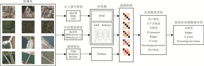
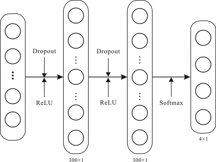
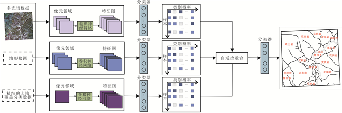
在东北地区选取试验区, 对比多种分类模型, 提出一种基于多源多模态数据和多流CNN的岩体分类模型. 其中包括两个子模型: 一是基于大尺度邻域和深度卷积神经网络的岩体提取模型; 二是基于波段组合和多模态数据的多流CNN融合模型. 研究结果表明, 预测结果图整体区域预测分布正确, 总体精度评价指标达到84.4%, 具有智能化程度高、客观性强的特点, 能够为地质工作者提供辅助决策依据. 此外, 还采用迁移学习策略对样本数量进行扩容, 解决了CNN模型小样本问题.
Abstract:A rock mass classification model based on multisource and multimodal data and multistream convolutional neural network(CNN) is proposed for the selected test areas in Northeast China with comparison of various other models. The model includes two submodels: the rock mass extraction model based on large-scale neighborhood and deep convolutional neural network(DCNN) and multistream CNN fusion model based on band combination and multimodal data. The application shows that the whole regional predicted distribution in the forecast result map is correct, with the overall accuracy evaluation index reaching 84.4%, characterized by high intelligence and strong objectivity, which can provide auxiliary decision-making basis for geologists. Besides, transfer learning strategy is used to expand the number of samples to solve the small sample problem of CNN model.
-

-
表 1 试验区使用的资源3号数据
Table 1. Data from ZY-3 satellite images used in test areas
试验区 数据 绥阳镇 ZY302_TMS_E131.0_N44.5_20191106_L1A0000591192-BWD ZY302_TMS_E131.0_N44.5_20191106_L1A0000591192-FWD ZY302_TMS_E131.0_N44.5_20191106_L1A0000591192-MUX ZY302_TMS_E131.0_N44.5_20191106_L1A0000591192-NAD 苇河镇 ZY302_TMS_E128.2_N44.9_20191002_L1A0000716815-BWD ZY302_TMS_E128.2_N44.9_20191002_L1A0000716815-FWD ZY302_TMS_E128.2_N44.9_20191002_L1A0000716815-MUX ZY302_TMS_E128.2_N44.9_20191002_L1A0000716815-NAD 亚布力镇 ZY302_TMS_E128.6_N44.9_20170302_L1A0000105807-BWD ZY302_TMS_E128.6_N44.9_20170302_L1A0000105807-FWD ZY302_TMS_E128.6_N44.9_20170302_L1A0000105807-MUX ZY302_TMS_E128.6_N44.9_20170302_L1A0000105807-NAD  下载: 导出CSV
表 2 试验区场景数据集
Table 2. Scene datasets of test areas
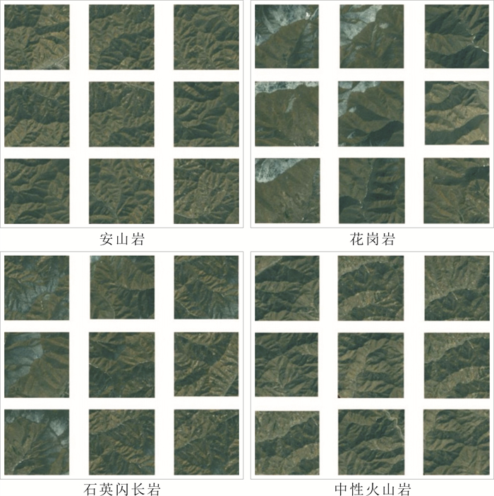
研究区 类别 数量 尺寸 影像分辨率 绥阳镇 安山岩 74 500 × 500像元
(真彩色、假彩色)
/210 × 210像元
(DEM)2.1 m(真彩
色、假彩色)/
5 m(DEM)板岩 16 第四系松散堆积物 50 花岗-闪长岩 168 砾岩 5 流纹岩 4 片岩 9 水 1 玄武岩 15 苇河镇 水 2 500×500像元
(真彩色、假彩色)
/210 × 210像元
(DEM)2.1 m(真彩
色、假彩色)/
5 m(DEM)板岩 7 花岗闪长岩类 238 黄土 1 片岩 2 松散堆积物 92 亚布力镇 水 5 500×500像元
(真彩色、假彩色)
/210 × 210像元(DEM)2.1 m(真彩
色、假彩色)/
5 m(DEM)花岗闪长岩类 242 片岩 12 松散堆积物 83
下载: 导出CSV
表 3 不同模型的总体性能
Table 3. Overall performance of different models
模型 OA/% Kappa/% F-score/% VGG 64.65 40.22 42.47 Xception 62.63 41.44 47.91 ResNet 61.62 42.57 55.32 CH 80.81 69.36 76.33 BoVW 58.59 30.64 43.32
下载: 导出CSV
表 4 不同模型总体性能的PD值
Table 4. PD values of overall performance for different models
模型 BoVW VGG Xception ResNet VGG 10.34/31.26/-1.95 Xception 6.90/35.25/10.61 ResNet 5.17/38.95/27.71 CH 25.00/72.47/79.71 29.03/67.39/59.30 31.15/62.93/37.98 表中PD值分别为OA/Kappa/F-score,单位:%.
下载: 导出CSV
表 5 不同模型统计检验结果
Table 5. Statistical test results of different models
模型 BoVW VGG Xception ResNet VGG 9.60(0.02) Xception 0.52(0.92) ResNet 12.96(0.00) CH 17.87(0.00) 3.67(0.30) 12.95(0.00) 注:括号前为卡方值,括号内为p值.
下载: 导出CSV
表 6 岩体模型精度评价结果
Table 6. Accuracy evaluation result of rock mass model
波段组合 Recall Precision F1 Kappa Acc 真彩色 0.892 0.754 0.800 0.783 0.844
下载: 导出CSV
-
[1] 李德仁, 童庆禧, 李荣兴, 等. 高分辨率对地观测的若干前沿科学问题[J]. 中国科学: 地球科学, 2012, 42(6): 805-813.
Li D R, Tong Q X, Li R X, et al. Current issues in high-resolution earth observation technology[J]. Science China Earth Sciences, 2012, 55(7): 1043-1051.
[2] 张良培, 黄昕. 遥感影像信息处理技术的研究进展(英文)[J]. 遥感学报, 2009, 13(4): 559-569.
Zhang L P, Huang X. Advanced processing techniques for remotely sensed imagery[J]. Journal of Remote Sensing, 2009, 13(4): 559-569.
[3] 邓志鹏, 孙浩, 雷琳, 等. 基于多尺度形变特征卷积网络的高分辨率遥感影像目标检测[J]. 测绘学报, 2018, 47(9): 1216-1227. https://www.cnki.com.cn/Article/CJFDTOTAL-CHXB201809008.htm
Deng Z P, Sun H, Lei L, et al. Object detection in remote sensing imagery with multi-scale deformable convolutional networks[J]. Acta Geodaetica et Cartographica Sinica, 2018, 47(9): 1216-1227. https://www.cnki.com.cn/Article/CJFDTOTAL-CHXB201809008.htm
[4] 付伟锋, 邹维宝. 深度学习在遥感影像分类中的研究进展[J]. 计算机应用研究, 2018, 35(12): 3521-3525. doi: 10.3969/j.issn.1001-3695.2018.12.001
Fu W F, Zou W B. Review of remote sensing image classification based on deep learning[J]. Application Research of Computers, 2018, 35(12): 3521-3525. doi: 10.3969/j.issn.1001-3695.2018.12.001
[5] 黄宜华. 大数据机器学习系统研究进展[J]. 大数据, 2015, 1(1): 35-54.
Huang Y H. Research progress on big data machine learning system [J]. Big Data Research, 2015, 1(1): 35-54.
[6] Hinton G E, Osindero S, Teh Y W. A fast learning algorithm for deep belief nets[J]. Neural Computation, 2006, 18(7): 1527-1554. doi: 10.1162/neco.2006.18.7.1527
[7] 姚承宽. 人工智能在测绘地理信息行业中的应用[J]. 河北省科学院学报, 2018, 35(4): 66-70. https://www.cnki.com.cn/Article/CJFDTOTAL-HBKX201804014.htm
Yao C K. Application of artificial intelligence in surveying and mapping geoinformation industry[J]. Journal of the Hebei Academy of Sciences, 2018, 35(4): 66-70. https://www.cnki.com.cn/Article/CJFDTOTAL-HBKX201804014.htm
[8] Araya-Polo M, Dahlke T, Frogner C, et al. Automated fault detection without seismic processing[J]. The Leading Edge, 2017, 36(3): 208-214.
[9] Lawrence S, Giles C L, Tsoi A C, et al. Face recognition: A convolutional neural-network approach[J]. IEEE Transactions on Neural Networks, 1997, 8(1): 98-113.
[10] Krizhevsky A, Sutskever I, Hinton G E. ImageNet classification with deep convolutional neural networks[C] //Proceedings of the 25th International Conference on Neural Information Processing Systems. Lake Tahoe: Curran Associates Inc., 2012: 1097-1105.
[11] Chen Y S, Jiang H L, Li C Y, et al. Deep feature extraction and classification of hyperspectral images based on convolutional neural networks[J]. IEEE Transactions on Geoscience and Remote Sensing, 2016, 54(10): 6232-6251.
[12] Chen S Z, Wang H P, Xu F, et al. Target classification using the deep convolutional networks for SAR images[J]. IEEE Transactions on Geoscience and Remote Sensing, 2016, 54(8): 4806-4817.
[13] Zhou Y, Wang H P, Xu F, et al. Polarimetric SAR image classification using deep convolutional neural networks[J]. IEEE Geoscience and Remote Sensing Letters, 2016, 13(12): 1935-1939.
[14] Romero A, Gatta C, Camps-Valls G. Unsupervised deep feature extraction for remote sensing image classification[J]. IEEE Transactions on Geoscience and Remote Sensing, 2016, 54(3): 1349-1362.
[15] Scott G J, England M R, Starms W A, et al. Training deep convolutional neural networks for land-cover classification of high-resolution imagery[J]. IEEE Geoscience and Remote Sensing Letters, 2017, 14(4): 549-553.
-
图(8)
表(6)
计量
- 文章访问数: 797
- PDF下载数: 6
- 施引文献: 0