

APPLICATION OF GEOPHYSICAL PROSPECTING AND REMOTE SENSING TECHNOLOGY IN MINE ECOLOGICAL RESTORATION: A Case Study of Xingtai Garden Expo Park
-
摘要:
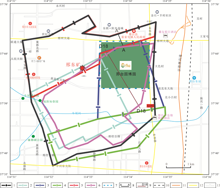
矿山经过多年开采, 地下形成采空区, 造成地面沉降, 开展绿色发展、生态修复工作刻不容缓. 冀中邢东煤矿由于长期开采, 造成不同程度地面塌陷, 不适于人类长期居住和农业耕作, 邢台市经研究决定在采煤塌陷区建设中央生态公园——邢台园博园. 基于此, 通过收集分析研究区内的地震、电法等物探资料, 确定煤矿煤层赋存形态、采空区范围及富水情况, 指导地面进行生态公园选址; 利用遥感技术监测矿山生态修复进度. 研究表明: 在矿区开展地震、电法工作查明煤矿开采生产情况, 对科学规划地面矿区生态修复工作具有指导意义; 利用遥感技术实时动态监测矿山生态修复进程, 可为生态环境修复提供数据基础, 对治理前后生态环境变化对比分析及效果评价提供影像资料.
Abstract:The green development and ecological restoration is urgent due to underground mined-out areas and ground subsidence formed after years of mining. As there are different degrees of ground collapse caused by long-term mining of Xingdong Coal Mine in central Hebei Province, the area is no longer suitable for permanent human residence and agricultural farming. Therefore the Xingtai City government decided to build the central ecological park-Xingtai Garden Expo Park in the coal mining subsidence area. Through collection and analysis of seismic, electrical and other geophysical data in the study area, the coal seam occurrence forms, range of mined-out areas and water-rich condition are determined to guide the site selection of ecopark. The progress of mine ecological restoration is monitored by remote sensing (RS) technology. The results show that ascertaining the situation of coal mining through geophysical exploration of seismic and electrical methods is significant to guide the scientific planning of ecological restoration in surface of mining areas, while the real-time dynamic monitoring of the mine ecological restoration process through RS can provide data basis for eco-environment restoration and image data for comparative analysis and effect evaluation of eco-environment changes before and after treatment.
-
Key words:
- geophysical prospecting /
- remote sensing /
- mined-out area /
- geological disaster /
- ecological restoration
-

-
[1] 陈晓冈. 工程物探技术在铁路路基检测中的应用研究[J]. 上海铁道科技, 2013(3): 109-110. https://www.cnki.com.cn/Article/CJFDTOTAL-TDKJ201303053.htm
Chen X G. Application of engineering geophysical technology in railway subgrade detection[J]. Shanghai Railway Science & Technology, 2013(3): 109-110. (in Chinese) https://www.cnki.com.cn/Article/CJFDTOTAL-TDKJ201303053.htm
[2] 沈大兴. 基于固体矿产的区域找矿技术的分析[J]. 中国石油和化工标准与质量, 2013(12): 112. doi: 10.3969/j.issn.1673-4076.2013.12.105
Shen D X. Analysis of regional prospecting technology based on solid minerals[J]. China Petroleum and Chemical Standard and Quality, 2013(12): 112. (in Chinese) doi: 10.3969/j.issn.1673-4076.2013.12.105
[3] 王明吉, 张哲, 姚勇, 等. 基于震电效应理论的一体化流体勘探仪[J]. 机械设计与制造, 2018(S2): 58-61. https://www.cnki.com.cn/Article/CJFDTOTAL-JSYZ2018S2015.htm
Wang M J, Zhang Z, Yao Y, et al. Seismo-electric integrated prospecting instrument[J]. Machinery Design & Manufacture, 2018(S2): 58-61. https://www.cnki.com.cn/Article/CJFDTOTAL-JSYZ2018S2015.htm
[4] 许海滨. 电法勘探在矿产勘探中的应用研究[J]. 环球市场, 2018(2): 362. https://www.cnki.com.cn/Article/CJFDTOTAL-COLO201705098.htm
Xu H B. Research on the application of electrical prospecting in mineral exploration[J]. Global Market, 2018(2): 362. (in Chinese) https://www.cnki.com.cn/Article/CJFDTOTAL-COLO201705098.htm
[5] 王志宏, 全旭东, 王利民, 等. 综合物探方法在硬岩型铀矿勘查中的应用研究[J]. 铀矿地质, 2015, 31(2): 110-120. https://www.cnki.com.cn/Article/CJFDTOTAL-YKDZ201502007.htm
Wang Z H, Quan X D, Wang L M, et al. Application of integrated geophysical survey to the exploration of hard rock hosted uranium deposits[J]. Uranium Geology, 2015, 31(2): 110-120. https://www.cnki.com.cn/Article/CJFDTOTAL-YKDZ201502007.htm
[6] 黄启春, 景朋涛. 可控源音频大地电磁测深法在煤矿采空区积水区勘查中的应用[J]. 工程地球物理学报, 2012, 9(3): 296-300. https://www.cnki.com.cn/Article/CJFDTOTAL-GCDQ201203011.htm
Huang Q C, Jing P T. Application of controlled source audio-frequency magnetotellurics method to mine gobs and water logged area investigation [J]. Chinese Journal of Engineering Geophysics, 2012, 9(3): 296-300. https://www.cnki.com.cn/Article/CJFDTOTAL-GCDQ201203011.htm
[7] 夏训银, 王身龙, 王洪生, 等. CSAMT方法在铁路隧道勘探中的应用[J]. 勘察科学技术, 2006(4): 61-64. https://www.cnki.com.cn/Article/CJFDTOTAL-KCKX200604015.htm
Xia X Y, Wang S L, Wang H S, et al. Application of CSAMT to exploration of railway tunnel[J]. Site Investigation Science and Technology, 2006(4): 61-64. https://www.cnki.com.cn/Article/CJFDTOTAL-KCKX200604015.htm
[8] 李江华, 刘超林, 柳杰, 等. 可控源音频大地电磁法在采空区勘探中的应用[J]. 中国煤炭, 2013, 39(1): 40-43. https://www.cnki.com.cn/Article/CJFDTOTAL-ZGME201301010.htm
Li J H, Liu C L, Liu J, et al. Application of CSAMT in exploration of goaf[J]. China Coal, 2013, 39(1): 40-43. https://www.cnki.com.cn/Article/CJFDTOTAL-ZGME201301010.htm
[9] 尹纪超. 可控源音频大地电磁(CSAMT)法在采空区勘查中的应用[J]. 勘察科学技术, 2017(6): 59-61. https://www.cnki.com.cn/Article/CJFDTOTAL-KCKX201706014.htm
Yin J C. Application of controlled source audio-frequency magnetotelluric sounding method (CSAMT) in goaf prospecting[J]. Site Investigation Science and Technology, 2017(6): 59-61. https://www.cnki.com.cn/Article/CJFDTOTAL-KCKX201706014.htm
[10] 杜珂. 基于深度学习的图像分类关键技术研究[D]. 长沙: 国防科学技术大学, 2016.
Du K. Research on the key technology of image classification based on deep learning[D]. Changsha: National University of Defense Technology, 2016.
[11] 武斌. 松潘甘孜地区地热资源的地球物理勘探研究[D]. 成都: 成都理工大学, 2013.
Wu B. Geophysical exploration of geothermal resources in the Songpan-Ganzi area[D]. Chengdu: Chengdu University of Technology, 2013.
[12] 许军强, 白朝军, 刘嘉宜. 基于遥感技术的长白山火山区地热预测研究[J]. 国土资源遥感, 2008(1): 68-71. https://www.cnki.com.cn/Article/CJFDTOTAL-GTYG200801014.htm
Xu J Q, Bai C J, Liu J Y. Geothermal prediction based on remote sensing technology in Changbaishan volcanic area[J]. Remote Sensing for Natural Resources, 2008(1): 68-71. https://www.cnki.com.cn/Article/CJFDTOTAL-GTYG200801014.htm
[13] 赵同阳, 周可法, 张晓帆, 等. 基于Canny算子的边缘检测技术在遥感地质填图中的应用——以西准包古图地区为例[J]. 新疆地质, 2008, 26(1): 95-99. https://www.cnki.com.cn/Article/CJFDTOTAL-XJDI200801021.htm
Zhao T Y, Zhou K F, Zhang X F, et al. Application of edge detection technology based on Canny algorithms in geological mapping: An example from Baogutu area, the Central Asia[J]. Xinjiang Geology, 2008, 26(1): 95-99. https://www.cnki.com.cn/Article/CJFDTOTAL-XJDI200801021.htm
[14] 王宇恒. 多旋翼无人机的发展历程及构型分析[J]. 科技传播, 2019, 11(22): 142-144. https://www.cnki.com.cn/Article/CJFDTOTAL-KJCB201922073.htm
Wang Y H. Development history and configuration analysis of multi rotor UAV[J]. Public Communication of Science & Technology, 2019, 11(22): 142-144. (in Chinese) https://www.cnki.com.cn/Article/CJFDTOTAL-KJCB201922073.htm
[15] 刘建晓, 孟令辉, 李辉, 等. 基于无人机遥感技术的衡水湖生态调查研究[J]. 衡水学院学报, 2019, 21(4): 1-5. https://www.cnki.com.cn/Article/CJFDTOTAL-HSSZ201904006.htm
Liu J X, Meng L H, Li H, et al. Ecological investigation of Hengshui Lake based on UAV remote sensing technology[J]. Journal of Hengshui University, 2019, 21(4): 1-5. https://www.cnki.com.cn/Article/CJFDTOTAL-HSSZ201904006.htm
[16] 邢元勋. 基于群体智能算法的无人机灾区搜救优化研究[D]. 大连: 大连理工大学, 2019.
Xing Y X. Research on search and rescue optimization of UAV disaster area based on swarm intelligence algorithm[D]. Dalian: Dalian University of Technology, 2019.
[17] 邱新分. 无人机技术在林业工作中的应用[J]. 吉林农业, 2019(12): 92-93. https://www.cnki.com.cn/Article/CJFDTOTAL-JNYZ201912079.htm
Qiu X F. Application of UAV technology in forestry[J]. Agriculture of Jilin, 2019(12): 92-93. (in Chinese) https://www.cnki.com.cn/Article/CJFDTOTAL-JNYZ201912079.htm
[18] 要书其. 浅谈构建绿色矿山的环保设计技术[J]. 河北煤炭, 2012(2): 1-2. https://www.cnki.com.cn/Article/CJFDTOTAL-HBMT201202002.htm
Yao S Q. Discussion on environmental protection design technology for building green mines[J]. Hebei Coal, 2012(2): 1-2. (in Chinese) https://www.cnki.com.cn/Article/CJFDTOTAL-HBMT201202002.htm
[19] 麻燕华. 可控源音频大地电磁法在查明煤矿富水性的应用[J]. 中国科技投资, 2017(1): 173-174.
Ma Y H. Application of controllable source audio frequency magnetotelluric method in identifying water abundance of coal mines [J]. China Venture Capital, 2017(1): 173-174. (in Chinese)
[20] 郑伟清. 邢东煤矿采空区综合勘察技术研究与应用[D]. 北京: 中国地质大学(北京), 2020.
Zheng W Q. Study and application of comprehensive survey technology in goaf of Xingdong coal mine[D]. Beijing: China University of Geosciences, 2020.
[21] 吴霞. 遥感技术在山水林田湖草生态修复的应用[J]. 地矿测绘, 2020, 3(3): 53-54.
Wu X. Application of remote sensing technology in ecological restoration of mountains, rivers, forests, fields, lakes and grasses[J]. Geological and Mineral Surveying and Mapping, 2020, 3(3): 53-54. (in Chinese)
-
 下载:
下载:
图(5)
计量
- 文章访问数: 993
- PDF下载数: 8
- 施引文献: 0