

SUSCEPTIBILITY ASSESSMENT OF LANDSLIDE AFTER RESERVOIR IMPOUNDMENT BASED ON ANALYTIC HIERARCHY PROCESS
-
摘要:
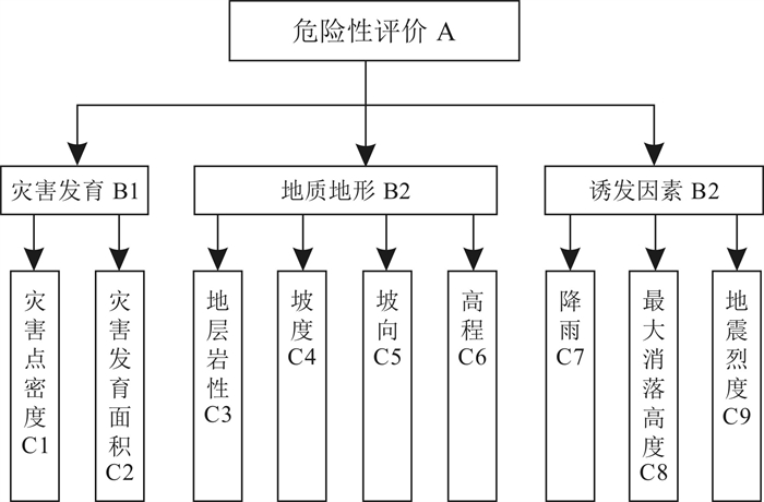
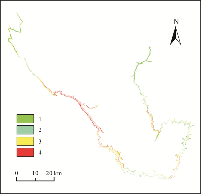
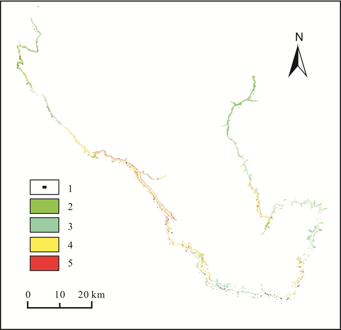
水库库区地形地质和水位地质条件复杂, 蓄水后受降雨和库水位变动影响容易产生滑坡、崩塌等次生地质灾害, 严重威胁水库安全运行和附近居民安全. 本文依托层次分析法, 以某蓄水水库为研究对象, 在充分收集其地形地质和水文条件资料的基础上, 选取地形地貌、地层岩性、坡度、坡向、地灾点密度、地灾点面积、降雨、库水变动幅度和地震强度等9个致滑因子, 构建评价矩阵和滑坡危险性计算评价方法. 依据评价成果划分4个滑坡危险性等级, 借助MapGIS软件生成库区潜在滑坡危险性分区图. 该分区图与遥感解译的库区滑坡体分布点高度吻合, 验证了评价模型的合理性.
Abstract:Reservoir areas are prone to secondary geological disasters such as landslides and collapses due to complex geological conditions involving topography and water level, which seriously threatens the safety of reservoirs and nearby residents. Taking a certain impoundment reservoir as the research object, 9 sliding factors including landform, stratum lithology, slope gradient, aspect, density and area of geohazard sites, precipitation, water storage variation and earthquake intensity are selected to construct the evaluation matrix and landslide risk calculation method on the basis of adequate data collection of topographic and hydrological conditions through analytic hierarchy process(AHP). Four landslide risk grades are divided according to the evaluation results, which then generate the potential landslide risk zoning map of the reservoir area by MapGIS. The zonation coincides highly with the distribution of landslide bodies interpreted by remote sensing, which proves that the evaluation model is effective.
-
Key words:
- analytic hierarchy process /
- reservoir /
- impoundment /
- landslide /
- geological hazard
-

-
表 1 致滑因子及其量化指标综合分类表
Table 1. Comprehensive classification of landslide factors and their quantitative indexes
指标大类 指标小类 量化等级与划分依据 1 2 3 4 灾害
程度
B1地灾点个数 0~3 3~6 6~9 大于9 地灾点面积 0~1 1~3 3~6 大于6 诱发
因素
B2降雨强度/
(mm/d)0~500 500~1000 1000~1500 大于1500 库水变动幅度 0~20 20~30 30~60 大于60 地形
地质
B3地震烈度 Ⅴ Ⅵ Ⅶ Ⅷ及以上 地层岩性 坚硬岩 中硬岩 较软岩 软岩及覆盖层 分布高程/m 0~1000 1000~1500 1500~2000 大于2000 地形坡度/(°) 0~15 15~30 30~45 大于45 坡面倾向/(°) 0~90 90~180 180~270 270~360  下载: 导出CSV
表 2 运筹标度指标
Table 2. Scale indexes of logistics operation research
标度值i 代表意义 1 两个子因子C1与Ci之间存在同等影响 3 两个子因子C1与Ci之间一方稍强 5 两个子因子C1与Ci之间存在明显一方更强 7 两个子因子C1与Ci之间,Cj比C1影响非常强 9 两个子因子C1与Ci之间,Cj比C1绝对强 2/4/6/8 两个子因子C1与Ci之间影响程度无法完全比较 1/i 两者之间存在反向关系
下载: 导出CSV
表 3 随机一致性指标R取值
Table 3. Random consistency index R value
阶数 1 2 3 4 5 6 R值 0.02 0.07 0.55 0.82 1.12 1.30
下载: 导出CSV
表 4 水库滑坡区至滑因子权重评估成果
Table 4. Weight evaluation results of landslide factors in reservoir landslide area
C层编号 B1层权重 B2层权重 B3层权重 C层权重 C1 0.45 0 0 0.27 C2 0.45 0 0 0.08 C3 0 0 0 0.21 C4 0 0.44 0 0.15 C5 0 0.23 0 0.15 C6 0 0.23 0.11 0.18 C7 0 0.35 0.13 0.08 C8 0.5 0.11 0.21 0.33 C9 0.5 0 0.5 0.05
下载: 导出CSV
-
[1] Naithani A K, Nawani P C, Singh L G, et al. Engineering geological evaluation of the spillway of dam (Ⅱ-B) of Bunakha hydroelectric project, Chukha Dzong, Bhutan[J]. Journal of the Geological Society of India, 2013, 81(6): 835-843. doi: 10.1007/s12594-013-0109-4
[2] Paraskevis N, Roumpos C, Stathopoulos N, et al. Spatial analysis and evaluation of a coal deposit by coupling AHP & GIS techniques[J]. International Journal of Mining Science and Technology, 2019, 29(6): 943-953. doi: 10.1016/j.ijmst.2019.04.002
[3] 祝清, 谭衢霖, 周嘉琦, 等. 基于GIS和AHP的福建福安区域滑坡地质灾害危险性评价[J]. 测绘与空间地理信息, 2021, 44(5): 25-30. doi: 10.3969/j.issn.1672-5867.2021.05.007
Zhu Q, Tan Q L, Zhou J Q, et al. Risk assessment of regional geological landslide hazards based on GIS and AHP in Fu'an City[J]. Geomatics and Spatial Information, 2021, 44(5): 25-30. doi: 10.3969/j.issn.1672-5867.2021.05.007
[4] 温金梅, 倪化勇, 王春山, 等. 砂泥岩互层斜坡演化及失稳特征研究——以三峡库区(长寿-丰都段)岸坡为例[J]. 工程地质学报, 2018, 26(S1): 76-84. https://cpfd.cnki.com.cn/Article/CPFDTOTAL-GCDZ201810001011.htm
Wen J M, Ni H Y, Wang C S, et al. Study on the evolution and failure characteristics of the interbeded slope of sand and mud stones: Taking the Three Gorges reservoir area (Changshou-Fengdu) as an example[J]. Journal of Engineering Geology, 2018, 26(S1): 76-84. https://cpfd.cnki.com.cn/Article/CPFDTOTAL-GCDZ201810001011.htm
[5] 王治华. 大型个体滑坡遥感调查[J]. 地学前缘, 2006, 13(5): 516-523. doi: 10.3321/j.issn:1005-2321.2006.05.018
Wang Z H. Large scale individual landslide remote sensing[J]. Earth Science Frontiers, 2006, 13(5): 516-523. doi: 10.3321/j.issn:1005-2321.2006.05.018
[6] 王佳运, 王根龙, 石小亚. 陕西山阳特大型滑坡视向滑移-溃屈破坏力学分析[J]. 中国地质, 2019, 46(2): 381-388. https://www.cnki.com.cn/Article/CJFDTOTAL-DIZI201902015.htm
Wang J Y, Wang G L, Shi X Y. Mechanical analysis of apparent dip creep-buckling failure of Shanyang super large-scale rockslide in Shaanxi Province[J]. Geology in China, 2019, 46(2): 381-388. https://www.cnki.com.cn/Article/CJFDTOTAL-DIZI201902015.htm
[7] 殷跃平, 王文沛, 张楠, 等. 强震区高位滑坡远程灾害特征研究——以四川茂县新磨滑坡为例[J]. 中国地质, 2017, 44(5): 827-841. https://www.cnki.com.cn/Article/CJFDTOTAL-DIZI201705002.htm
Yin Y P, Wang W P, Zhang N, et al. Long runout geological disaster initiated by the ridge-top rockslide in a strong earthquake area: A case study of the Xinmo landslide in Maoxian County, Sichuan Province [J]. Geology in China, 2017, 44(5): 827-841. https://www.cnki.com.cn/Article/CJFDTOTAL-DIZI201705002.htm
[8] 高永志, 初禹, 薛广垠, 等. 黑龙江省矿山地质灾害遥感调查研究[J]. 地质与资源, 2017, 26(2): 161-164, 189. http://manu25.magtech.com.cn/Jweb_dzyzy/CN/abstract/abstract8521.shtml
Gao Y Z, Chu Y, Xue G Y, et al. Remote sensing survey of geological hazards of mines in Heilongjiang Province[J]. Geology and Resources, 2017, 26(2): 161-164, 189. http://manu25.magtech.com.cn/Jweb_dzyzy/CN/abstract/abstract8521.shtml
[9] 何光洪, 梁燕, 邓炎倩, 等. 基于层次分析法的泾阳南塬黄土滑坡影响因素综合研究[J]. 水利与建筑工程学报, 2021, 19(2): 66-70, 148. https://www.cnki.com.cn/Article/CJFDTOTAL-FSJS202102012.htm
He G H, Liang Y, Deng Y Q, et al. Comprehensive research on influencing factors of loess landslides in southern Jingyang Plateau based on analytic hierarchy process[J]. Journal of Water Resources and Architectural Engineering, 2021, 19(2): 66-70, 148. https://www.cnki.com.cn/Article/CJFDTOTAL-FSJS202102012.htm
[10] Griffiths J S. Technical note: Terrain evaluation in engineering geology[J]. Quarterly Journal of Engineering Geology and Hydrogeology, 2017, 50(1): 3-11.
[11] Kanik M, Ersoy H. Evaluation of the engineering geological investigation of the Ayvali dam site (NE Turkey)[J]. Arabian Journal of Geosciences, 2019, 12(3): 89.
[12] 秦先燕, 彭苗枝, 焦团理, 等. 基于GIS的环巢湖地区地质环境承载能力评价[J]. 地质与资源, 2020, 29(2): 180-186. http://manu25.magtech.com.cn/Jweb_dzyzy/CN/abstract/abstract10190.shtml
Qin X Y, Peng M Z, Jiao T L, et al. Assessment of GIS-based geological environment carrying capacity in circum-Chaohu Lake area, Anhui, China[J]. Geology and Resources, 2020, 29(2): 180-186. http://manu25.magtech.com.cn/Jweb_dzyzy/CN/abstract/abstract10190.shtml
[13] 唐尧, 王立娟, 马国超, 等. 利用国产遥感卫星进行金沙江高位滑坡灾害灾情应急监测[J]. 遥感学报, 2019, 23(2): 252-261. https://www.cnki.com.cn/Article/CJFDTOTAL-YGXB201902007.htm
Tang Y, Wang L J, Ma G C, et al. Emergency monitoring of high-level landslide disasters in Jinsha River using domestic remote sensing satellites[J]. Journal of Remote Sensing, 2019, 23(2): 252-261. https://www.cnki.com.cn/Article/CJFDTOTAL-YGXB201902007.htm
[14] 丁宇雪, 毛龙, 周向斌, 等. 基于高分影像的松嫩低平原地区生态环境问题解析——以黑龙江省肇源县为例[J]. 吉林大学学报(地球科学版), 2020, 50(4): 1240-1248. https://www.cnki.com.cn/Article/CJFDTOTAL-CCDZ202004028.htm
Ding Y X, Mao L, Zhou X B, et al. Analysis of eco-environmental problems in Songnen low plain based on high-score image: A case study of Zhaoyuan County of Heilongjiang Province[J]. Journal of Jilin University (Earth Science Edition), 2020, 50(4): 1240-1248. https://www.cnki.com.cn/Article/CJFDTOTAL-CCDZ202004028.htm
[15] 余飞燕, 吕蒙, 杨军. 云南省镇雄县滑坡地质灾害主要致灾因子筛选及危险性分区[J]. 地质与资源, 2015, 24(2): 152-156. http://manu25.magtech.com.cn/Jweb_dzyzy/CN/abstract/abstract8720.shtml
Yu F Y, Lü M, Yang J. Risk zoning and disaster-inducing factor screening of landslide in Zhenxiong County, Yunnan Province[J]. Geology and Resources, 2015, 24(2): 152-156. http://manu25.magtech.com.cn/Jweb_dzyzy/CN/abstract/abstract8720.shtml
[16] 何满潮, 崔政权, 陈鸿汉, 等. 三峡库区巫山古滑坡系统构造形变场研究[J]. 工程地质学报, 1998, 6(2): 97-102. https://www.cnki.com.cn/Article/CJFDTOTAL-GCDZ802.000.htm
He M C, Cui Z Q, Chen H H, et al. Study of tectonic deformation field for Wushan paleo-landslide system in the Three-Gorges reservoir area[J]. Journal of Engineering Geology, 1998, 6(2): 97-102. https://www.cnki.com.cn/Article/CJFDTOTAL-GCDZ802.000.htm
[17] 赵力行, 范文, 柴小庆, 等. 秦巴山区地质灾害发育规律研究——以镇巴县幅为例[J]. 地质与资源, 2020, 29(2): 187-195. http://manu25.magtech.com.cn/Jweb_dzyzy/CN/abstract/abstract10191.shtml
Zhao L X, Fan W, Chai X Q, et al. Study on the development regularity of geohazards in Qinling-Daba mountains: A case study of Zhenba County, Shaanxi Province[J]. Geology and Resources, 2020, 29(2): 187-195. http://manu25.magtech.com.cn/Jweb_dzyzy/CN/abstract/abstract10191.shtml
[18] 房浩, 李媛, 杨旭东, 等. 2010-2015年全国地质灾害发育分布特征分析[J]. 中国地质灾害与防治学报, 2018, 29(5): 1-6. https://www.cnki.com.cn/Article/CJFDTOTAL-ZGDH201805001.htm
Fang H, Li Y, Yang X D, et al. Distribution characters of geo-hazards in China during the period of 2010-2015[J]. The Chinese Journal of Geological Hazard and Control, 2018, 29(5): 1-6. https://www.cnki.com.cn/Article/CJFDTOTAL-ZGDH201805001.htm
[19] 熊倩莹. 基于1: 5万地质灾害填图的区域地质灾害易发性及危险性的评价与区划——以茂汶羌族自治县幅为例[D]. 成都: 成都理工大学, 2015.
Xiong Q Y. Based on 1: 50000 geological hazard mapping of regional geological hazards and risk assessment and regionalization: Shigeru to Brunei Qiang Autonomous County as an example[D]. Chengdu: Chengdu University of Technology, 2015.
[20] 杨乐, 彭海游, 周莫林, 等. 基于层次分析法的奉节县城地质环境承载力评价[J]. 重庆交通大学学报(自然科学版), 2014, 33(2): 95-99. https://www.cnki.com.cn/Article/CJFDTOTAL-CQJT201402021.htm
Yang L, Peng H Y, Zhou M L, et al. Assessment of geological environment carrying capacity of Fengjie County based on AHP[J]. Journal of Chongqing Jiaotong University (Natural Science), 2014, 33(2): 95-99. https://www.cnki.com.cn/Article/CJFDTOTAL-CQJT201402021.htm
-

图(4)
表(4)
计量
- 文章访问数: 1343
- PDF下载数: 6
- 施引文献: 0