

APPLICATION OF AHP-INFORMATION METHOD IN GEOLOGICAL HAZARD SUSCEPTIBILITY EVALUATION BASED ON SLOPE UNIT
-
摘要:
基于ArcGIS的地质灾害风险评价方法多种多样, 但在致灾因素多样与复杂的沟谷地区, 传统的易发性评价模型的评价精度难以满足实际需求. 基于斜坡单元法的地质灾害易发程度分析可以充分体现控制因素和诱发因素的综合作用, 而基于层次分析法(AHP)的信息量法既可以把灾害诱发因素按支配关系形成有序的分组和分层, 又可以使统计分析评价与定量模型相结合, 从而对斜坡体的评价更为有效, 适用性更强. 因此, 本研究将基于斜坡单元的易发性评价方法与基于层次分析法的信息量法相结合, 并加入斜坡类型评价因子, 以陕西省略阳县灾害易发性评价区划为例, 通过空间叠加分析得出易发评价区划并检验评价精度. 研究结果符合实际情况, 可为该地区地质灾害精细化评价和防灾减灾提供依据.
Abstract:The accuracy of conventional susceptibility evaluation models cannot meet the actual needs in gully areas with diverse and complex disaster-causing factors despite various geological hazard risk assessment methods based on ArcGIS. The analysis of geohazard susceptibility based on slope element can fully reflect the combination of controlling and inducing factors, while the information method based on analytic hierarchy process(AHP) can not only form orderly groups and layers of disaster-inducing factors in terms of dominant relation, but also combine statistical analysis and evaluation with quantitative model, therefore the evaluation of slope body is more effective and more applicable. In this study, taking the disaster susceptibility evaluation zoning in Lueyang County of Shaanxi Province as an example, the combination of both methods above as well as slope type evaluation factor is used for prone area evaluation/division and verification of evaluation accuracy through spatial overlay analysis. The results are consistent with actual situation, which can provide basis for accurate evaluation and disaster prevention and mitigation of geohazards in the area.
-

-
表 1 评价因子相关性指标
Table 1. Evaluation factor correlation indexes
指标因素 坡度 地形起伏度 地貌类型 工程地质岩组 距断裂距离 距河流距离 斜坡结构 距道路距离 降雨 坡度 1 地形起伏度 0.06604 1 地貌类型 0.38187 -0.00282 1 工程地质岩组 0.16820 0.09524 0.11265 1 距断裂距离 0.05247 0.12452 0.22145 -0.1214 1 距河流距离 0.12827 0.03712 0.13715 0.09854 0.11524 1 斜坡结构 0.26581 -0.03046 0.03982 -0.05247 -0.1254 -0.11642 1 距道路距离 0.35389 0.03585 0.29501 0.15855 -0.2571 0.3911 0.09715 1 降雨 0.05647 -0.2354 0.05248 0.15425 -0.07451 0.09632 -0.03251 0.13325 1  下载: 导出CSV
表 2 组合权重值
Table 2. Combination weight values
评价因子 基本因素0.25 诱发因素0.75 信息量值 坡度 0.189085769 0 0.047271442 地形起伏度 0.187319973 0 0.046829993 岩土体类型 0.199201753 0 0.049800438 斜坡结构 0.291517283 0 0.072879321 距断层距离 0.057359656 0 0.014339914 地貌类型 0.075515567 0 0.018878892 降雨 0 0.75 0.5625 距河流距离 0 0.25 0.1875
下载: 导出CSV
表 3 评价因子总信息量值
Table 3. Total information values of evaluation factors
评价指标 分类 综合信息量值 评价指标 分类 综合信息量值 地貌类型 侵蚀-堆积河谷地貌 0.042826443 距断层距离/m 0~50 0.038017614 剥蚀低山 -0.015629303 50~100 0.040412811 剥蚀中山 -0.03655337 100~150 0.032338443 剥蚀高中山 -0.113252565 距河流距离/m 0~80 0.173053513 工程地质岩组 黄土砂砾石 -0.010989068 80~160 0.17627817 坚硬层状碎屑岩 -0.007214364 160~240 0.164009716 半坚硬层状碎屑岩 -0.002740889 240~320 0.144892847 坚硬块状侵入岩 0.071921853 坡度/(°) 0~20 0.010444135 坚硬厚层状变质岩 0.033541693 20~40 0.011127452 坚硬块状火山岩 -0.030582714 40~60 -0.01073437 半坚硬变质火山岩 -0.01163327 >60 0.059361957 半坚硬浅变质岩 -0.011854545 地形起伏度/m 0~15 0.000122767 坚硬厚层状碳酸盐 0.04869429 15~30 0.001988307 坚硬中厚层状碳酸盐 -0.003411976 30~45 -0.01236846 软硬相间层状混合岩 -0.048320688 >45 0.035848282 斜坡结构 碎屑岩斜向坡 0.905981538 降雨量/mm 815~820 0.01872365 碎屑岩顺向坡 0.606544748 820~825 0.01152565 碎屑岩逆向坡 0.47008391 825~830 0.12365585 岩浆岩斜向坡 0.348168021 830~835 -0.0256325 岩浆岩逆向坡 0.135068399 835~840 -0.0125362 岩浆岩顺向坡 0.110945003 840~845 0.0326524 碎石土变质岩斜坡 0.023865723 845~850 0.0265214 碎石土岩浆岩斜坡 -0.348511892 850~855 0.0236514 碎石类斜坡 -0.370656802 855~860 -0.0326157 粘土类斜坡 -0.669424773 860~865 0.02123655 变质岩斜向坡 -0.718596473 865~870 0.01125365 变质岩横向坡 -0.820794828 黄土碎屑岩斜坡 -0.948740441 黄土斜坡 -0.8926745
下载: 导出CSV
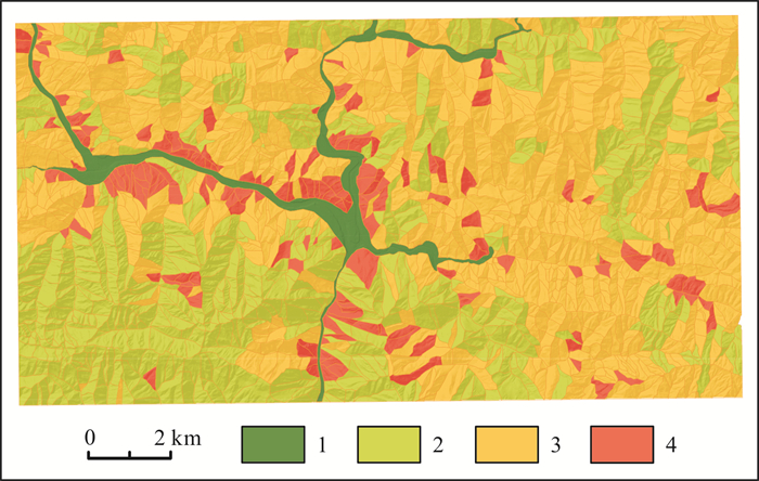
表 4 斜坡单元评价结果表
Table 4. Evaluation results of slope units
易发区划 灾点数量/个 斜坡单元/个 斜坡单元面积/km2 占比/% 灾点密度/(个/km2) 高易发区 85 134 14.5406 9.03142857 6.53343 中易发区 44 156 68.7182 48.8932919 45.48484 低易发区 24 226 52.2152 38.642981 19.15151 非易发区 0 55 25.7195 3.552484 0
下载: 导出CSV
-
[1] 张春山, 何淑军, 辛鹏, 等. 陕西省宝鸡市渭滨区地质灾害风险评价[J]. 地质通报, 2009, 28(8): 1053-1063. doi: 10.3969/j.issn.1671-2552.2009.08.007
Zhang C S, He S J, Xin P, et al. Risk evaluation of geological hazards in Weibin District, Baoji City, Shaanxi Province, China[J]. Geological Bulletin of China, 2009, 28(8): 1053-1063. doi: 10.3969/j.issn.1671-2552.2009.08.007
[2] Alparslan E, Ince F, Erkan B, et al. A GIS model for settlement suitability regarding disaster mitigation, a case study in Bolu Turkey [J]. Engineering Geology, 2008, 96(3/4): 126-140.
[3] Turk T, Gümüsşay U, Tatar O. Creating infrastructure for seismic microzonation by Geographical Information Systems (GIS): A case study in the North Anatolian Fault Zone (NAFZ)[J]. Computers & Geosciences, 2012, 43: 167-176.
[4] 薛强, 张茂省, 高波, 等. 陕西省绥德县城区地质灾害风险评估[J]. 工程地质学报, 2018, 26(3): 711-719. doi: 10.13544/j.cnki.jeg.2017-205
Xue Q, Zhang M S, Gao B, et al. Risk assessment of geological hazards in Suide City, Shaanxi Province[J]. Journal of Engineering Geology, 2018, 26(3): 711-719. doi: 10.13544/j.cnki.jeg.2017-205
[5] Rupke J, Cammeraat E, Seijmonsbergen AC, et al. Engineering geomorphology of the Widentobel catchment, Appenzell and Sankt Gallen, Switzerland: A geomorphologuical inventory system applied to geotechnical appraisal of slope stability[J]. Engineering Geology, 1988, 26(1): 33-68. doi: 10.1016/0013-7952(88)90005-1
[6] Montgomery D R, Dietrich W E. A physically based model for the topographic control on shallow landsliding[J]. Water Resources Research, 1994, 30(4): 1153-1171. doi: 10.1029/93WR02979
[7] Pourghasemi H R, Mohammady M, Pradhan B. Landslide susceptibility mapping using index of entropy and conditional probability models in GIS: Safarood Basin, Iran[J]. CATENA, 2012, 97: 71-84. doi: 10.1016/j.catena.2012.05.005
[8] Che V B, Kervyn M, Suh C E, et al. Landslide susceptibility assessment in Limbe (SW Cameroon): A field calibrated seed cell and information value method[J]. CATENA, 2012, 92: 83-98. doi: 10.1016/j.catena.2011.11.014
[9] 郭万铭, 焦金鱼. 基于模糊综合评判法分析的岷县洮河流域单沟泥石流危险性评价[J]. 地质灾害与环境保护, 2010, 21(2): 15-18, 36. https://www.cnki.com.cn/Article/CJFDTOTAL-DZHB201002009.htm
Guo W M, Jiao J Y. Hazard assessment of single gully debris flows in the Taohe River valley of Min County based on fuzzy comprehensive evaluation method[J]. Journal of Geological Hazards and Environment Preservation, 2010, 21(2): 15-18, 36. https://www.cnki.com.cn/Article/CJFDTOTAL-DZHB201002009.htm
[10] 张茂省, 薛强, 贾俊, 等. 山区城镇地质灾害调查与风险评价方法及实践[J]. 西北地质, 2019, 52(2): 125-135. https://www.cnki.com.cn/Article/CJFDTOTAL-XBDI201902017.htm
Zhang M S, Xue Q, Jia J, et al. Methods and practices for the investigation and risk assessment of geo-hazards in mountainous towns [J]. NorthwesternGeology, 2019, 52(2): 125-135. https://www.cnki.com.cn/Article/CJFDTOTAL-XBDI201902017.htm
[11] 薛强, 张茂省, 李林. 基于斜坡单元与信息量法结合的宝塔区黄土滑坡易发性评价[J]. 地质通报, 2015, 34(11): 2108-2115. doi: 10.3969/j.issn.1671-2552.2015.11.017
Xue Q, Zhang M S, Li L. Loess landslide susceptibility evaluation based on slope unit and information value method in Baota District, Yan'an[J]. Geological Bulletin of China, 2015, 34(11): 2108-2115. doi: 10.3969/j.issn.1671-2552.2015.11.017
[12] 田述军, 张珊珊, 唐青松, 等. 基于不同评价单元的滑坡易发性评价对比研究[J]. 自然灾害学报, 2019, 28(6): 137-145. https://www.cnki.com.cn/Article/CJFDTOTAL-ZRZH201906015.htm
Tian S J, Zhang S S, Tang Q S, et al. Comparative study of landslide susceptibility assessment based on different evaluation units[J]. Journal of Natural Disasters, 2019, 28(6): 137-145. https://www.cnki.com.cn/Article/CJFDTOTAL-ZRZH201906015.htm
[13] 温金梅, 杨龙, 苟敬, 等. 基于信息量法的地质灾害易发性评价——以重庆市巫山县县城为例[J]. 地质与资源, 2021, 30(2): 193-198, 192. http://manu25.magtech.com.cn/Jweb_dzyzy/CN/abstract/abstract10284.shtml
Wen J M, Yang L, Gou J, et al. Evaluation of geohazard susceptibility based on information method: A case study of Wushan County in Chongqing Municipality[J]. Geology and Resources, 2021, 30(2): 193-198, 192. http://manu25.magtech.com.cn/Jweb_dzyzy/CN/abstract/abstract10284.shtml
[14] 吴常润, 赵冬梅, 刘澄静, 等. 基于GIS和信息量模型的陇川县滑坡易发性评价[J]. 西北地质, 2020, 53(2): 308-320. https://www.cnki.com.cn/Article/CJFDTOTAL-XBDI202002024.htm
Wu C R, Zhao D M, Liu C J, et al. Landslide susceptibility assessment of longchuan county based on GIS and information value model[J]. Northwestern Geology, 2020, 53(2): 308-320. https://www.cnki.com.cn/Article/CJFDTOTAL-XBDI202002024.htm
[15] 朱进守, 邓辉, 苑泉, 等. 藏东高山峡谷地带地质灾害危险性评价——以西藏贡觉县为例[J]. 地质与资源, 2018, 27(3): 272-278. http://manu25.magtech.com.cn/Jweb_dzyzy/CN/abstract/abstract8466.shtml
Zhu J S, Deng H, Yuan Q, et al. Risk assessment on the geohazards in alpine and gorge region of eastern Tibet: A case study of Gonjo County[J]. Geology and Resources, 2018, 27(3): 272-278. http://manu25.magtech.com.cn/Jweb_dzyzy/CN/abstract/abstract8466.shtml
[16] 吴树仁, 石菊松, 张春山, 等. 地质灾害风险评估技术指南初论[J]. 地质通报, 2009, 28(8): 995-1005. https://www.cnki.com.cn/Article/CJFDTOTAL-ZQYD200908002.htm
Wu S R, Shi J S, Zhang C S, et al. Preliminary discussion on technical guideline for geohazard risk assessment[J]. Geological Bulletin of China, 2009, 28(8): 995-1005. https://www.cnki.com.cn/Article/CJFDTOTAL-ZQYD200908002.htm
[17] 黄润秋. 20世纪以来中国的大型滑坡及其发生机制[J]. 岩石力学与工程学报, 2007, 26(3): 433-454. https://www.cnki.com.cn/Article/CJFDTOTAL-YSLX200703000.htm
Huang R Q. Large-scale landslides and their sliding mechanisms in China since the 20th Century[J]. Chinese Journal of Rock Mechanics and Engineering, 2007, 26(3): 433-454. https://www.cnki.com.cn/Article/CJFDTOTAL-YSLX200703000.htm
[18] 张茂省, 李同录. 黄土滑坡诱发因素及其形成机理研究[J]. 工程地质学报, 2011, 19(4): 530-540. https://www.cnki.com.cn/Article/CJFDTOTAL-GCDZ201104015.htm
Zhang M S, Li T L. Triggering factors and forming mechanism of loess landslides[J]. Journal of Engineering Geology, 2011, 19(4): 530-540. https://www.cnki.com.cn/Article/CJFDTOTAL-GCDZ201104015.htm
-
图(12)
表(4)
计量
- 文章访问数: 1280
- PDF下载数: 22
- 施引文献: 0