

QUANTITATIVE ANALYSIS OF THE ECOLOGICAL SEDIMENT REPLENISHMENT AT THE NORTHERN NATURE RESERVE OF YELLOW RIVER DELTA
-
摘要:
自1976年黄河尾闾改道以来,流往黄河三角洲北岸的刁口河段结束行水,海岸失去陆源泥沙补给后在海洋动力的作用下发生持续侵蚀,黄河三角洲北部自然保护区湿地生态资源面临威胁。为了解黄河三角洲北部自然保护区近几十年来水下地形的冲淤变化,并对未来侵蚀形势进行估计,根据黄河三角洲北岸实测水深资料,运用空间插值分析技术,计算各时期研究区水下地形并叠加分析。结合黄河利津站历史来水来沙资料的统计,尝试提出在新水沙形势下对黄河三角洲北岸的分沙补偿侵蚀定量方案。结果表明,1992—2015年,该区常年发生持续冲刷,年均侵蚀量为0.29×10⁸ t,年均侵蚀厚度为0.14 m,侵蚀速率稳定。经计算,在干流水库调水调沙期间通过刁口河道以约1 200 m3/s的流速持续引水19 d,可以有效缓解该自然保护区的侵蚀现状,具体的方案和工程实施仍需后续细化。
Abstract:The northern coast of the Yellow River Delta has lost its sediment supply from the Yellow River basin and experienced continuous erosion under ocean power since the cut-off of Diaokou River in 1976. The ecological resources of wetland in the Yellow River Delta Northern Nature Reserve (YRDNNR), located at the mouth of the Diaokou River, are thus under threat. The erosion of YRDNNR was evaluated by using spatial analysis technique based on the topography data measured on the north bank of the Yellow River Delta in this paper. The results show that from year 1992 to 2015, continuous erosion occurred in this area, the annual erosion volume reached 2 856×104 t, the annual eroded thickness was 9.3 cm, and the erosion rate remained rather stable. Based on the historical runoff of Lijin hydrological station of the Yellow River, the paper tries to put forward a quantitative scheme to compensate the erosion in the YRDNNR. According to the analysis, during the period of water-sediment modulation, water diversion through Diaokou River at a flow rate of 1 200 m3/s for 19 days can effectively alleviate the erosion of the reserve.
-
Key words:
- Yellow River Delta /
- coastal erosion /
- sediment replenishment
-

-
表 1 水下地形水深变化情况
Table 1. Water-depth variation of study area
年份 1992 2000 2007 2015 最大水深/m 4.2 5.9 8.1 8.9 平均水深/m 1.8 2.1 2.8 3.4  下载: 导出CSV
表 2 黄河三角洲北部自然保护区各等深线后退速率
Table 2. The receding rates of isohypses of YRDNNR
时段 时长/a 等深线/m 后退距离/km 后退速率/km·a−1 1992—2000 8 1 1.6 0.20 2 1.2 0.16 3 1.1 0.14 4 − − 2000—2007 7 1 1.3 0.18 2 1.6 0.23 3 1.3 0.19 4 1.1 0.16 2007—2015 8 1 0.8 0.10 2 0.2 0.03 3 0.7 0.09 4 0.9 0.12 1992—2015 23 1 3.7 0.16 2 3.0 0.14 3 3.0 0.13 4 − − 注:1992年的4 m等深线在研究区范围外,因此不分析1992—2000、2000—2015年的等深线后退情况。
下载: 导出CSV
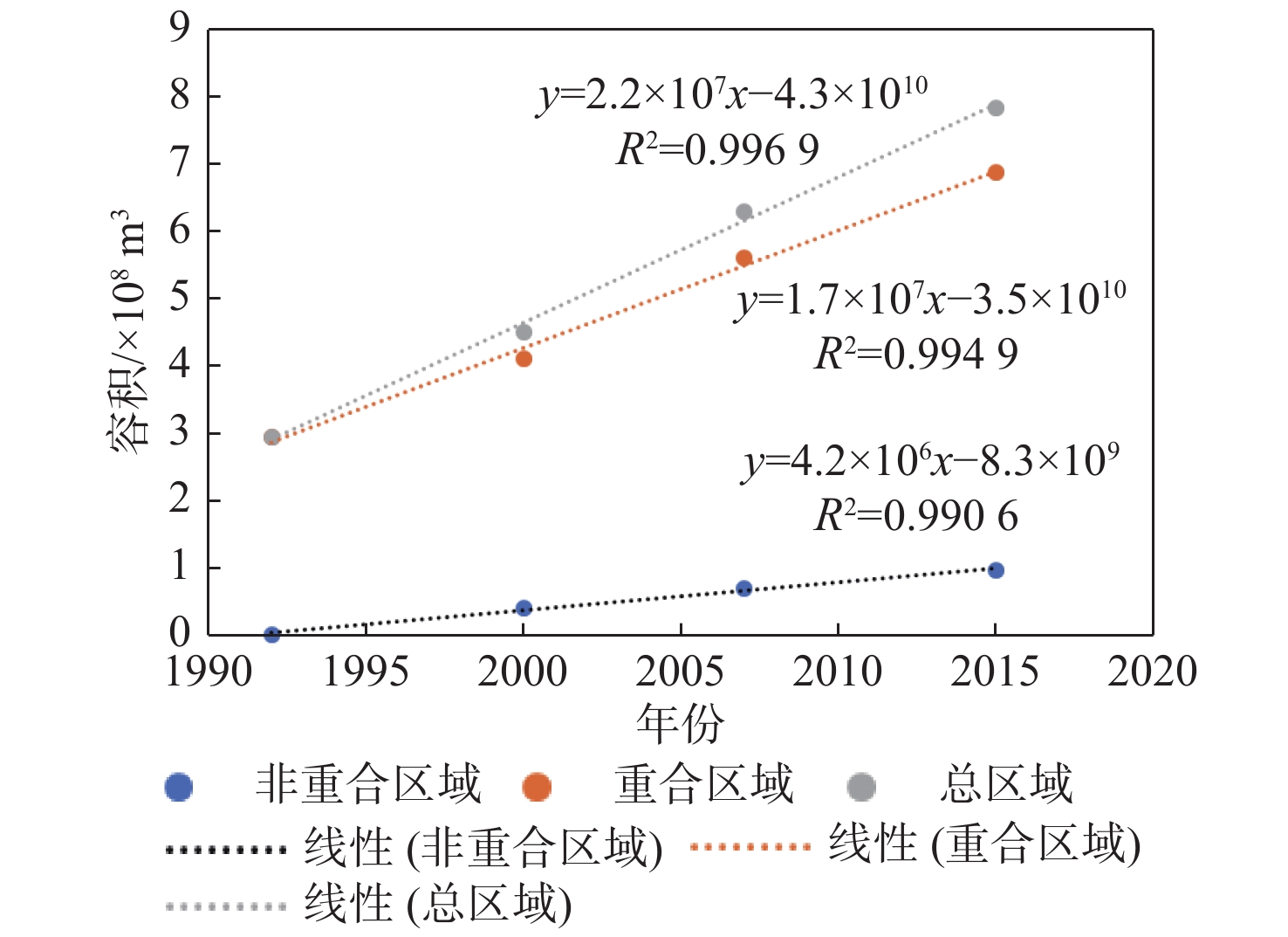
表 3 自然保护区各期水下地形0 m水深以下容积
Table 3. The volumes below 0 m of underwater topography in YRDNNR
/108 m3 年份 1992 2000 2007 2015 重合区域 2.95 4.11 5.61 6.89 非重合区域 0 0.40 0.70 0.96 总研究区域 2.95 4.51 6.31 7.85
下载: 导出CSV
表 4 不同时段研究区海域冲淤变化
Table 4. The scour rates in different time period
时段/年 时长/a 冲刷量/108 t 年均冲刷量/108 t 平均冲刷深度/m 1992—2000 8 2.13 0.27 0.09 2000—2007 7 2.44 0.35 0.14 2007—2015 8 2.10 0.26 0.10 1992—2015 23 6.67 0.29 0.14
下载: 导出CSV
表 5 2002—2014年黄河调水调沙利津站水沙信息
Table 5. The water and sediment flux of Lijin Hydroligical Gauging Station during water-sediment modulation period between 2002 and 2014
年份 调水调沙时
间/(月.日)天数 年输沙量/
108t调水调沙输
沙量/108t输沙量
比例/%径流量
比例/%调水调沙平均悬
沙浓度/(kg·m−3)平时悬沙浓
度/(kg·m−3)调水调沙平均
流量/m3·s−1平时流量/
m3·s−12002 7.4−7.15 12 0.54 0.25 45.49 25.97 22.67 9.53 1 051.8 101.9 2003 9.6−9.18 13 3.70 0.97 26.33 11.40 44.33 15.96 1 956.2 561.5 2004 6.19−7.13 25 2.58 0.58 22.46 19.94 14.60 12.55 1 835.2 541.8 2005 6.9−7.1 23 1.91 0.52 27.04 15.65 15.97 8.00 1 629.0 590.3 2006 6.10−6.29 20 1.49 0.54 36.33 21.37 13.18 6.28 2 370.5 505.7 2007 6.19−7.7
7.29−8.729 1.47 0.82 34.64 17.65 15.23 4.36 2 139.0 518.1 2008 6.22−7.9 18 0.77 0.58 74.89 26.98 14.70 1.82 2 525.9 354.7 2009 6.22−7.10 18 0.56 0.41 72.38 28.23 10.84 1.63 2 411.3 318.1 2010 6.22−7.12 21 1.67 0.66 39.34 23.14 14.74 6.84 2 460.6 499.0 2011 6.24−7.10 17 0.93 0.35 37.64 18.91 10.00 3.87 2 372.4 496.8 2012 6.24−7.16 22 1.83 0.60 33.05 17.05 12.55 5.22 2 533.6 790.7 2013 6.22−7.12 21 1.73 0.54 31.41 21.75 10.53 6.39 2 840.0 623.7 2014 7.3−7.13 11 0.30 0.17 57.26 16.94 8.92 1.36 2 037.3 310.3 多年平均 − 19 1.50 0.54 35.85 20.42 14.71 6.75 2 198.0 477.9
下载: 导出CSV
表 6 设计引沙方案
Table 6. The schemes of sediment transport
方案 流量和引沙天数指标 只于调水调沙期间引沙  = 0,
= 0, = 0,
= 0, = 19 d,
 = 1 200 m3·s−1
只于平时引沙  = 166 d,
 = 300 m3·s−1,
 = 0,
= 0, = 0
= 0调水调沙和平时综合引沙  = 79 d,
 = 300 m3·s−1,
 = 10 d,
 = 1 200 m3·s−1
下载: 导出CSV
= 1 200 m3·s−1
下载: 导出CSV
-
[1] 周云轩,田波,黄颖,等. 我国海岸带湿地生态系统退化成因及其对策[J]. 中国科学院院刊,2016,31(10):1157-1166.
[2] 张晓龙. 现代黄河三角洲滨海湿地环境演变及退化研究[D]. 青岛: 中国海洋大学, 2005.
[3] 李九发, 时连强, 应铭, 等. 黄河河口钓口河流路亚三角洲岸滩演变与抗冲性试验[M]. 北京: 海洋出版社, 2013: 14.
[4] 王开荣,李岩,于守兵,等. 黄河刁口河备用流路现状及保护工程措施探讨[J]. 中国水利,2017(1):15-19. doi: 10.3969/j.issn.1000-1123.2017.01.005
[5] 葛海燕. 刁口河尾闾黄河三角洲自然保护区生态补水效果评估[J]. 山东林业科技,2012,42(5):34-36. doi: 10.3969/j.issn.1002-2724.2012.05.010
[6] 李士国, 李延波. 黄河刁口河流路生态补水试验及效果分析[C]//第三届全国河道治理与生态修复技术交流研讨专刊. 北京: 中国水利技术信息中心, 2015: 13.
[7] 孙莉,司晓磊,廖展强. 黄河三角洲北区湿地生态需水量研究[J]. 人民黄河,2010,32(12):112-113. doi: 10.3969/j.issn.1000-1379.2010.12.046
[8] FANG H L,XU J. Land cover and vegetation change in the Yellow River Delta nature reserve analyzed with Landsat Thematic Mapper data[J]. Geocarto International,2000,15(4):43-50. doi: 10.1080/10106040008542171
[9] FAN Y S,CHEN S L,ZHAO B,et al. Monitoring tidal flat dynamics affected by human activities along an eroded coast in the Yellow River Delta,China[J]. Environmental monitoring and assessment,2018,190(7):396. doi: 10.1007/s10661-018-6747-7
[10] 燕峒胜, 蒲高军, 张建华, 等. 黄河三角洲胜利滩海油区海岸蚀退与防护研究[M]. 郑州: 黄河水利出版社, 2006.
[11] 师长兴,章典,尤联元,等. 黄河口泥沙淤积估算问题和方法:以钓口河亚三角洲为例[J]. 地理研究,2003(1):49-59. doi: 10.3321/j.issn:1000-0585.2003.01.006
[12] 陈沈良,谷硕,姬泓宇,等. 新入海水沙情势下黄河口的地貌演变[J]. 泥沙研究,2019,44(5):61-67.
[13] WANG H J, YANG Z S, SAITO Y, et al. Stepwise decreases of the Huanghe (Yellow River) sediment load (1950-2005): Impacts of climate change and human activities[J]. Global and Planetary Change, 2007, 57(3/4): 331-354.
[14] 刘静. 黄河河口三角洲湿地生态补水实践[EB/OL]. https://max.book118.com/html/2018/1022/7012052163001153.shtm, 2019-7-4: 22-24.
[15] 杨作升,李国刚,王厚杰,等. 55年来黄河下游逐日水沙过程变化及其对干流建库的响应[J]. 海洋地质与第四纪地质,2008,28(6):9-18.
[16] 司敬玲,张月明. 黄河三角洲刁口河生态调水实践[J]. 人民黄河,2013,35(2):30-32, 35. doi: 10.3969/j.issn.1000-1379.2013.02.011
[17] YU Y G,SHI X F,WANG H J,et al. Effects of dams on water and sediment delivery to the sea by the Huanghe (Yellow River):The special role of Water-Sediment Modulation[J]. Anthropocene,2013,3:72-82. doi: 10.1016/j.ancene.2014.03.001
[18] 李国英. 黄河首次调水调沙[J]. 科学,2003,55(1):41-44,2.
[19] 陈沈良,张国安,谷国传. 黄河三角洲海岸强侵蚀机理及治理对策[J]. 水利学报,2004(7):1-6,13. doi: 10.3321/j.issn:0559-9350.2004.07.001
[20] 王建中, 王道席.黄河河口地区生态流量调度初步研究[C]//第三届黄河国际论坛论文集.郑州: 黄河水利出版社, 2007: 3 - 8.
[21] 陈雄波, 雷鸣, 王鹏. 清水沟、刁口河流路联合运用方案比选[J]. 海洋工程, 2014, 32(4):117-123.
-


图(5)
表(6)
计量
- 文章访问数: 470
- PDF下载数: 9
- 施引文献: 0