Semi-quantitative restoration of paleobathymetric of Baiyun Sag of Pearl River Mouth Basin based on depositional architecture
-
摘要:
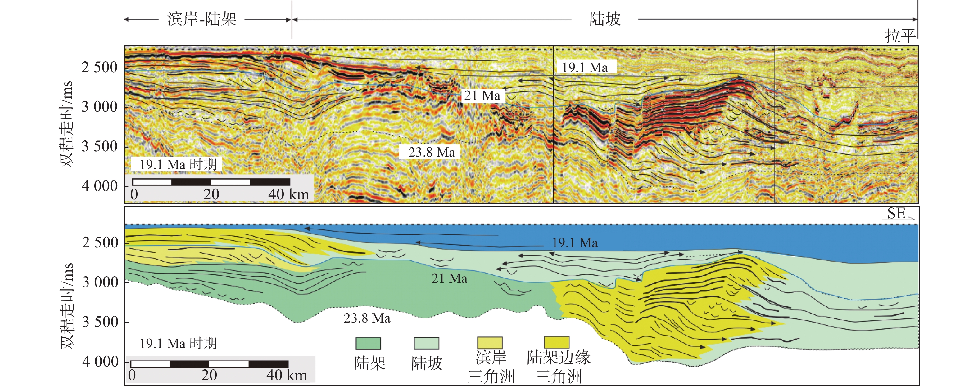
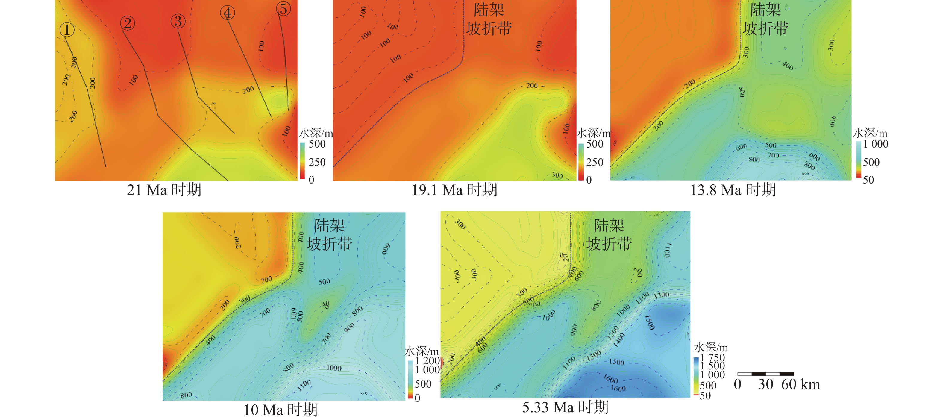
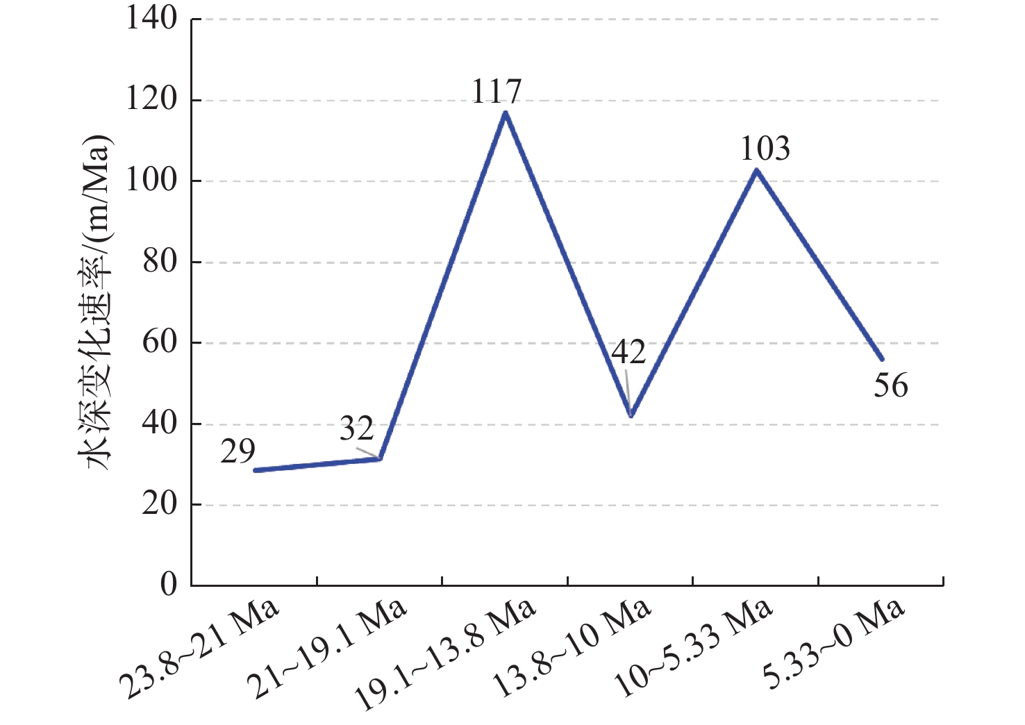
针对南海北部深水沉积盆地的古水深恢复这一难题,以珠江口盆地白云凹陷为例,根据陆架陆坡沉积特征,通过在三级层序格架内精细地震线描和层拉平恢复结合的沉积构型技术对白云凹陷裂后阶段5个关键地质时期(21 Ma、19.1 Ma、13.8 Ma、10 Ma和5.33 Ma)古水深进行研究。结果表明,21 Ma、19.1 Ma时期平均古水深<300 m,之后至13.8 Ma时期最大水深900 m。10 Ma和5.33 Ma时期,水深由1 100 m扩大至1 600 m。从21~5.33 Ma时期,陆架坡折带沿NW-SE向分布在白云北坡,古水深表现为西北陆架区浅,东南陆坡-深海平原区水体深。白云凹陷古水深整体上经历了浅海-半深海-深海的水体持续加深过程,存在2期(13.8 Ma和5.33 Ma)水深速率相对其他时期变快的时期,古水深变化速率分别为117和103 m/Ma,13.8 Ma时期水体加深速率最大。古水深的研究成果对白云凹陷热沉降史和沉积古地貌形态恢复具有重要研究意义。
Abstract:Aiming at reconstruction of paleobathymetric depth in the deep-water sedimentary basins in the northern South China Sea, this paper takes the Baiyun Sag of the Pearl River Mouth Basin as an example. According to the sedimentary characteristics of the continental shelf and slope, this study is based on depositional architecture by characterization of seismic profile and bedding flattening in third-order sequence in five critical geological stages(21, 19.1, 13.8, 10 and 5.33 Ma) of post-rift stage in Baiyun Sag. The results show that the average paleobathymetric depth in the 21 Ma and 19.1 Ma stages is less than 300 m, from then to 13.8 Ma, the maximum paleobathymetric depth is 900 m. During the 10 Ma and 5.33 Ma stages, the paleobathymetric depth expanded from 1100 m to 1600 m. From 21 Ma to 5.33 Ma, the shelf break belt had spreaded along the northwest-southeast direction on the northern slope of Baiyun Sag. The paleobathymetric depth of northwest shelf area is shallow, and the southeast continental slope and deep sea plain area is deep on the plane. The paleobathymetric depth of the Baiyun Sag had undergone a continuous deepening process of shallow sea to semi-deep sea and finally deep sea, and there were two stages (13.8 Ma and 5.33 Ma) much faster paleobathymetric depth rate than other stage in Baiyun Sag, the paleo-water depth change rate is 117 m/Ma and 103 m/Ma respectively,and the deepening rate of the paleobathymetric depth was the largest in the 13.8 Ma stage. The result of paleobathymetric has important research and guiding significance for the determination of the key parameters of paleobathymetric for thermal depression history research and the restoration of sedimentary paleomorphology.
-
Key words:
- paleobathymetric /
- semi-quantitative /
- sedimentary architecture /
- Baiyun Sag /
- Pearl River Mouth Basin
-
1. 引言
晋南–豫西地区大地构造位置处于华北陆块南缘和秦岭造山带。以栾川–维摩寺–明港断裂为界,北部属于华北陆块,南部属于秦岭造山带(图1)。在漫长的地质演化史中,经历多期构造变动,地质构造极为复杂,发展演化历程独特(图2)。其中,中条山、登封–鲁山–小秦岭、东秦岭造山带等地区历来被地质学家所关注(孙大中等,1993;白瑾等,1997;许志琴,1988;贾承造等,1988;游振东等,1991;高联达等,1991;张宏飞等,1996;许继锋等,1996;张国伟等,2001;张本仁等,2002;杨经绥等,2002;赵太平等,2004;赵凤清等,2006;王宗起等,2009;王晓霞等,2015;Zhai MG et al., 2000;刘良等,2013;Yang Y et al.,2013,2017;Dong YP et al., 2014;杨崇辉等,2015;李承东等,2018;Yang WT et al., 2018;Wu K et al., 2018;Cao Y et al., 2018;Zhang J et al., 2018;李万忠等,2018;牛绍武等,2018;Xu ZQ et al., 2020)。
晋南–豫西地区1∶500 000数字地质图空间数据库(表1,赵利刚等,2020)汲取了近些年形成的1∶50 000、1∶250 000区域地质调查成果,并在此基础上对重点地层和岩浆岩进行了剖面测量和系统采样等工作,重新厘定了一些关键地层的时代,如通过对洛峪群洛峪口组凝灰岩进行LA-MC-ICPMS锆石U–Pb测年,获得1634±10 Ma、1638±8.8 Ma的年龄,将其划分为长城系(李承东等,2017),初步建立了本区中–上元古界地层对比格架。将原龟山岩组厘定为东秦岭造山带内俯冲增生杂岩,由新元古代、早古生代等岩块和基质构成,是商丹俯冲带的东延,形成时代为早古生代(常青松等,2018;李承东等,2019);子母沟组不是一个地层单位,是朱夏俯冲带中的构造混杂岩,对其进行解体;从而提出了东秦岭造山带结构及演化的新方案。根据近些年来公开发表文献和区域地质调查工作所获得的同位素年代学数据,对区内岩浆岩时代进行了更新。
表 1. 数据库(集)元数据简介条目 描述 数据库(集)名称 晋南–豫西地区1∶500 000数字地质图空间数据库 数据库(集)作者 赵利刚,中国地质调查局天津地质调查中心
李承东,中国地质调查局天津地质调查中心
许雅雯,中国地质调查局天津地质调查中心
许 腾,中国地质调查局天津地质调查中心
曾 威,中国地质调查局天津地质调查中心
翟文建,河南省地质调查院
任建德,河南省地质调查院
李建荣,山西省地质调查院
方怀宾,河南省地质调查院数据时间范围 2010–2019年 地理区域 东经110°20′~116°40′; 北纬31°15′~36°20′ 数据格式 MapGIS 数据量 476 MB 数据服务系统网址 http://dcc.cgs.gov.cn 基金项目 中国地质调查局地质调查项目“中条–熊耳山成矿区地质矿产调查”(项目编号: DD20160043)资助 语种 中文 数据库(集)组成 该数据库包括1∶500 000地质图库和图饰。地质图库包括沉积岩、岩浆岩、火山岩、变质岩、脉岩、构造、地质界线、产状、各类代号等; 图饰包括: 图例、地层分区图及表、责任表 2. 数据采集和处理方法
2.1 数据基础
晋南–豫西地区1∶500 000数字地质图空间数据库以板块构造及地球动力学理论等为指导,以1∶500 000河南省地质图和1∶500 000山西省地质图为基础,充分利用1∶250 000、1∶50 000区域地质调查成果和公开发表的论文、专著等研究新进展,地理底图采用国家基础地理信息中心2002 年版最新1∶1 000 000国际分幅数字地形图,收集的地质资料截至2018年12月,部分期刊论文截至2019年底。应用已有的技术标准以及国内和国际上通用的计算机软件进行数据处理和管理,按1∶500 000比例尺地质图精度要求,建立晋南–豫西地区地质图空间数据库。
2.2 数据处理过程
晋南–豫西地区1∶500 000数字地质图空间数据库及地质图的数据处理过程与其他数字地质图(庞健峰等,2017;李晨阳等,2019;贺根文等,2019)相似,详细过程如下:
(1)首先应用河南省和山西省1∶500 000地质图数据库,根据编图范围进行裁剪、合并。在此基础上,结合最新资料,在综合研究的基础上,应用地球科学的新理论、新方法和新技术,以《山西省岩石地层》和《河南省岩石地层》为依据,将地层进行归纳、合并;根据最新的资料,重新厘定地层和岩浆岩时代。按1∶500 000地质图编图要求,将最新的1∶250 000和1∶50 000地质图幅扫描生成TIF格式文件,在MapGIS 系统下进行线元矢量化编辑、修改、归并,生成WL文件;输入注记代号生成WT文件。通过投影转换、误差校正与处理好的1∶500 000地质底图套合、拼接,校样输出,检查修改;在屏幕上修改、编辑、审查、输出,进行初审。拓扑造区,填色整饰,生成 WP 文件。编图工作流程见图3。
(2)编写属性表。在MapGIS 6.5 平台上,输出属性表,应用其他的软件(如Excel),进行属性的修改、补充,进行编码的转换等,然后打印输出属性表,人工检查属性内容,之后再与图形数据进行关联。
(3)地质内容和地理底图进行严格套合,每幅图选取35 个校正控制点,保证经纬网误差和图廓点误差小于或等于0.1 mm。
(4)数据接边处理:对地质图数据库进行投影转换,转换成地理坐标系后,首先与提供的理论框套合。其次再与邻幅接边处理。具体处理步骤为:①地质内容衔接一致;②为了使地质图无缝入库,与邻幅地质界线衔接时,采用每一条接边线进行抓线头处理,保证了地质界线无缝衔接。
(5)1∶500 000地质图的图外整饰采用统一要求,图例编排的位置、字体的大小采用统一规格,图例内容按照地层、侵入岩、火山岩、特殊地质体、第四纪成因类型及花纹、火山岩花纹、地质界线、构造界线的顺序进行编排。
(6)属性数据检查。项目组编写了属性检查软件,进行属性数据的检查,包括属性结构、属性类型、属性内容等,同时结合人工检查的方法,尽量将错误率降到最低。
3. 数据样本描述
3.1 图层名称
地质图和地理底图图层主要按要素类型划分,以文件的形式存放。
3.2 地质图数据的命名方式
省份+地质面.WP,省份+地质线.WL,省份+地质点.WT。
3.3 要素(实体)类型名称
实体类型名称:点、面、线段。
点实体:同位素、地质体注记、地质符号、地质花纹。
面实体:地层、侵入体等。
线段实体:断裂构造、整合、不整合、平行不整合、岩相界线等。
3.4 属性列表
晋南—豫西地区1∶500 000数字地质图空间数据库包括地质实体要素信息和地理要素信息,地质实体包含的属性有:地层面元属性表、断层线属性表、地质体边界线属性表。
地质体面元属性表主要是包括地层和侵入岩单位,其属性结构如下:ID(标识码);面积;周长;SYMBOL(地质代号);地层名称;岩性;面色 CLR(色标号):填写色标号;图案号(填充图案号);图案颜色(填充图案颜色号);图案高(填充图案高度);图案宽(填充图案宽度)等。
断层属性表:ID (标识码);长度;FEATURE ID(属性编号);CHFCAC(图元编号);GZBD(接触关系); PKIGJ(资料来源)。
地质体边界线属性表:ID(标识码);长度;FEATURE ID(属性编号);CHFCAC(图元编号);GZBD(接触关系);PKIGJ(资料来源)。
4. 数据质量控制和评估
晋南–豫西地区1∶500 000地质图主要以1∶250 000数字地质图库为基础,收集地质大调查以来的成果资料(如1∶50 000地质图)、研究区重要的前人科研成果以及本次研究成果编绘而成。具体收集的资料包括最新完成的郑州市幅、洛阳市幅、内乡县幅、平顶山市幅、枣阳市幅、信阳市幅等6幅1∶250 000地质图,2013–2016年完成的16幅1∶50 000地质图(表2),并参考了同时期进行的山西省绛县幅(I49E004015)、垣曲县幅(I49E005015)、同善镇幅(I49E005016),河南省二郎坪幅(I49E015015)、小水幅(I49E016015)、夏馆幅(I49E016016)、白土街幅(I49E012014)、三川幅(I49E013014)等共计8幅1∶50 000地质图。此外,还搜集了2019年以来公开发表的专著和期刊论文,共计479篇参考文献。
表 2. 豫西地区2013–2016年完成的16幅1∶50 000地质图一览表序号 图幅名称 完成单位 工作周期 1 大口集幅(I49E009019)
府店幅(I49E009020)
江左幅(I49E010019)
大金店幅(I49E010020)河南省地质调查院;
河南理工大学2010–2012年 2 官庄幅(I49E019022)
泌阳县幅(I49E020022)
平氏幅(I49E021021)
马道幅(I49E021022)河南省地质矿产勘查开发局
第三地质矿产调查院2012–2014年 3 西承留幅(I49E006018)
济源幅(I49E006019)
北马屯幅(I49E007018)
冶戍镇幅(I49E007019)河南省地质调查院 2012–2014年 4 石门幅(I49E017018)
内乡幅(I49E018016)
镇平幅(I49E018017)
安皐幅(I49E018018)河南省地质调查院 2014–2016年 数据质量控制方面,在工作中建立了完整的工作日志表,每个作业人员每天必须按要求填写工作日志,将每天的工作内容全面、完整的记录下来,并由作业组长签名认可。建立完整的自检、互检表,每个作业人员作一幅图都要进行100%的自检,并将自检结果和修改处理结果如实、完整的记录下来,由作业组长签名认可。在自检的基础上,由项目负责人安排其他作业人员进行60%以上的互检,并将互检结果和修改处理结果如实、完整的记录下来,由作业组长签名认可。每幅图完成后,由项目负责抽取10%进行检查,并确保检查内容全部符合质量要求。
5. 数据价值
5.1 晋南–豫西地区中—上元古界地层划分新方案
编图过程中,聚焦本区关键地质问题开展了区域性年代学研究工作。①在豫西地区洛峪群洛峪口组凝灰岩夹层中获得锆石U–Pb同位素年龄(ICP-MS)为(1634±10) Ma、(1638±8.8) Ma,将汝阳群、洛峪群归属长城系;②获得栾川群大红口组碱性火山岩年龄为(838±11) Ma,将该群厘定为青白口系;③获得高山河组安山岩夹层的年龄为1754 Ma,限定了高山河组(群)形成时代的下限;④获得熊耳群最早流纹岩年龄为(1820±15) Ma,确认熊耳群底部属于古元古代,其底界年龄大于1800 Ma。综合本次年代学工作,建立了晋南–豫西地区中—上元古界地层划分新方案(图4)。
5.2 秦岭造山带构造结构划分新方案
对秦岭造山带关键地层、岩浆岩进行了系统的研究。①将原龟山岩组进行了解体,厘定为俯冲增生杂岩,不具有地层属性,是商丹断裂带的东延; ②秦岭岩群由不同时代的岩片构成,包括片麻岩岩片、大理岩岩片等,其中有大量新元古代变质侵入岩是俯冲增生杂岩中的一个巨大块体,其本身也经历深俯冲; ③宽坪岩群时代由原来的新元古代或者新元古代–早古生代厘定为新元古代–晚泥盆世,构造属性为大陆边缘海盆地; ④重新梳理了二郎坪群各组之间的接触关系,认为二郎坪群最早形成的地层为火神庙组。火神庙组、大庙组、小寨组和抱树坪组不完全是上下关系,它们之间存在平行即同时异相的关系。由此,提出了秦岭造山带构造结构划分的新方案(图1),体现了该地质图编制的创新性。
6. 数据使用方法和建议
晋南–豫西地区1∶500 000数字地质图空间数据库充分吸收了最新的地质调查和科研成果,体现了编图内容的实时性。本数据库采用MapGIS 6.7通用格式建立,编图思想先进,内容丰富、直观,可编辑性强,可与同类型数据实现叠加、合并与再处理,便于数据库的管理与信息共享。数据库集成了最新的地质调查和科研成果,可作为以后地质调查和科研工作的基础图件。
7. 结论
(1)晋南–豫西地区1∶500 000数字地质图空间数据库集成了晋南中条山地区和豫西、豫西南地区区域地质调查和专题研究的最新成果资料,以板块构造及地球动力学理论等为指导,应用地理信息系统和地质制图等新技术和新方法,按照1∶500 000地质图编制精度,通过开展综合研究与数字地质图编制工作完成,具有较强时效性和创新性。
(2)围绕晋南—豫西地区内重大地质问题,通过中–上元古界地层对比和秦岭造山带结构与演化研究,建立了中–上元古界地层划分的新方案,提出了秦岭造山带结构与演化的新模式。
致谢:在地质图编制过程中,得到河南省地质矿产勘查开发局总工程师张良,河南省地质调查院李中明、王世炎,山西省地质调查院孙占亮,天津地质调查中心赵凤清、辛后田等研究员和教授级高级工程师指导和帮助,在此一并表示感谢。
1. Introduction
The geodetic location of the southern Shanxi—western Henan region is in the southern margin of the North China Block and Qinling orogenic belt. The region is bounded by the Luanchuan-Weimosi-Minggang fault, its northern part lies in the North China Block and its southern part lies in the Qinling orogenic belt (Fig. 1). In the long history of geological evolution, it has experienced multiple tectonic changes, with an extremely complex tectonic structure, unique development and evolutionary process (Fig. 2). Within the region, areas such as the Zhongtiaoshan, Dengfeng – Lushan – Xiaoqinling and Eastern Qinling orogenic belt have always received much attention from geologists (Sun DZ, 1993; Bai J et al., 1997; Xu ZQ, 1988; Jia CZ et al., 1988; You ZD et al., 1991; Gao LD et al., 1991; Zhang HF et al., 1996; Xu JF et al., 1996; Zhang GW et al., 2001; Zhang BR et al., 2002; Yang JS et al., 2002; Zhao TP et al., 2004; Zhao FQ et al., 2006; Wang ZQ et al., 2009; Wang XX et al., 2015; Zhai MG et al., 2000; Liu L et al., 2013; Yang Y et al., 2013, 2017; Dong YP et al., 2014; Yang CH et al., 2015; Li CD et al., 2018; Yang WT et al., 2018; Wu K et al., 2018; Cao Y et al., 2018; Zhang J et al., 2018; Li WZ et al., 2018; Niu SW et al., 2018; Xu ZQ et al., 2020).
I — North China Block; I1 — Xiong’er Meso – Neoproterozoic Rift; I2 — Paleozoic epicontinental sea and carbonate platform in Shanxi and Henan; I3 — Mesozoic intracontinental basin; I4 — Linfen – Yuncheng Cenozoic rift basin; II —Qinling orogenic belt; II1 —Kuanping Neoproterozoic – Early Palaeozoic continental marginal sea basin; II2 —Erlangping early Palaeozoic island arc and back-arc basin; II3 —Zhu – Xia early Palaeozoic ophiolite mélange; II4 —Zhaigen – Shuanglong early Palaeozoic high pressure – ultra high pressure metamorphic zone (North Qinling microcontinent); II5 —Zhenping – Guishan (Shang – Dan) early Palaeozoic subduction – accretionary complex; II6 —Douling – Dabie Proterozoic microcontinentFigure 1. Diagram of the tectonic unit division in the southern Shanxi – western Henan regionTo compile the 1∶500 000 digital geological map spatial database of the southern Shanxi – western Henan region (Table 1, Zhao LG et al., 2020), we consulted the results of the 1∶500 000 and 1∶250 000 regional geological surveys in recent years, and conducted a geological profile survey and systematic sampling of key strata and magmatic rock; and in the process, redating some key strata. For example, through the LA-MC-ICPMS zircon U–Pb dating of the tuff of the Luoyukou Formation in the Luoyu Group, the ages that were obtained were 1634±10 Ma and 1638±8.8 Ma, thus classifying it into the Changcheng System (Li CD et al., 2017), initially establishing the middle–upper Proterozoic stratigraphic correlation framework in this area. The original Guishan Formation was determined as a subduction–accretionary complex within the Eastern Qinling orogenic belt, which is composed of Neoproterozoic and early Palaeozoic rock blocks and matrices, which signifies that the eastern extension of the Shangdan Subduction Belt was formed in the early Palaeozoic (Chang QS et al., 2018; Li CD et al., 2019); the Zimugou Formation is not a stratigraphic unit, but is in actual fact a subduction mélange in the Zhuxia Subduction Belt and was categorized into different eras. Therefore, a new scheme for the structure and evolution of the Eastern Qinling orogenic belt was proposed. Based on the isotopic chronological data from publications and regional geological survey work in recent years, the era of the magmatic rocks in the region was updated.
Table 1. Metadata Table of Database (Dataset)Items Description Database (dataset) name Spatial Database of the 1∶500 000 Digital Geological Map of Southern Shanxi–Western Henan Database (dataset) authors Zhao Ligang, Tianjin Center, China Geological Survey
Li Chengdong, Tianjin Center, China Geological Survey
Xu Yawen, Tianjin Center, China Geological Survey
Xu Teng, Tianjin Center, China Geological Survey
Zeng Wei, Tianjin Center, China Geological Survey
Zhai Wenjian, Henan Institute of Geological Survey
Ren Jiande, Henan Institute of Geological Survey
Li Jianrong, Shanxi Institute of Geological Survey
Fang Huaibin, Henan Institute of Geological SurveyData acquisition time 2010 – 2019 Geographic area 110°20′ – 116°40′E; 31°15′ – 36°20′N Data format MapGIS Data size 476 MB Data service system URL http://dcc.cgs.gov.cn Fund project China Geological Survey Project titled ‘Geological and Mineral Resource Survey in Zhongtiao–Xiong'ershan Metallogenic Area’ (DD20160043) Language Chinese Database (dataset) composition The database includes 1∶500 000 geological map library and map appearance. The geological map library includes sedimentary rock, igneous rock, magmatic rock, metamorphic rock, dike, tectonics, geological boundary line, attitude, and various codes. Map appearance includes legend, stratigraphic subdivision map and table, and duty table 2. Data Acquisition and Processing Methods
2.1 Data Source
The1∶500 000 Digital Geological Map Spatial Database of the Southern Shanxi – Western Henan Region is guided by the theory of plate tectonics and geodynamics. The database is based on the 1∶500 000 geological maps of Henan Province and Shanxi Province, which made full use of the findings from the 1∶250 000 and 1∶50 000 regional geological surveys as well as the research results in newly published papers and monographs, and also adopted the latest 1∶1 000 000 international sheet division (2002 edition) of the National Geomatics Center of China (NGCC) for geographical base maps. The collected geological data were from as recent as December 2018, while some journal papers were published up to the end of 2019. The existing technical standards and commonly used computer software in China and abroad were adopted for data processing and management. The1∶500 000 Digital Geological Map Spatial Database of the Southern Shanxi – Western Henan Region was created in conformity with the accuracy requirements of geological maps on a 1∶500 000 scale. 2.2 Data Processing
The data processing of the 1∶500 000 Digital Geological Map Spatial Databaseand geological maps of the southern Shanxi – western Henan Region is similar to other digital geological maps (Pang JF et al., 2017; Li CY et al., 2019; He GW et al., 2019), with the detailed process as follows:
(1) Firstly, the 1∶500 000 geological map databases of Henan and Shanxi were adopted, which were cut and merged according to the mapping scope. The latest data and comprehensive research were referred to and the latest theories, methods and techniques of geophysics were applied in order to group and merge the strata according to both ‘Lithostratigraphy in Shanxi Province’ and ‘Lithostratigraphy in Henan Province’; the eras of strata and magmatic rock were consequently redated according to the latest data. In conformity with the mapping requirements of 1∶500 000 geological maps, the latest 1∶250 000 and 1∶50 000 geological maps were scanned to generate.TIF files, and line elements were vectorized, modified and merged to form.WL files, and generate.WT files after entering annotation codes. The files were matched with the processed 1∶500 000 geological base map through projection conversion and error correction. The samples were output, examined and modified before being revised, edited, checked and output onto the screen for preliminary examination. Then topological area creation, color filling and finishing were completed to generate.WP files. See Fig. 3 for the compilation work flow.
(2) The attribute tables were compiled. On the MapGIS 6.5 platform, the attribute tables were output and other software (e.g., Excel) were used to modify and complete attributes, and convert codes, before outputting attribute tables. The attribute contents were manually checked before being correlated with graphic data.
(3) The geological content was strictly matched with the geographical base map. Thirty-five correction control points were selected for each map-sheet to ensure that the errors of the graticule and the point of map border were less than or equal to 0.1 mm.
(4) Data edge matching: projection transformation was carried out on the geological map database, and was firstly matched with the given theoretical framework after being transformed to a geographical coordinate system, before edge matching with the adjacent map-sheet. The specific steps are as follows: i) ensure that the geological contents are consistent; ii) in order to smoothly input the geological map into the database, each edge line head is aligned when matching with geological boundary lines in the adjacent map-sheet for a seamless connection.
(5) Uniform requirements were adhered to for the exterior finishing of the 1∶500 000 geological map and uniform specifications were adopted for the location and font size of the legend. The legend’s contents were arranged in the order of strata, intrusive rock, volcanic rock, special geobody, Quaternary genetic types and patterns, volcanic rock patterns, geological boundary line, and tectonic boundary.
(6) Attribute data examination. The project team developed a piece of software for attribute examination, which includes the examination of attribute structure, attribute type, attribute contents, among others. This measure, coupled with manual examination, would help to minimize error rates.
3. Data Sample Description
3.1 Layer Name
Geological map and geographical base map layers were mainly divided according to the feature types and stored in the form of files.
3.2 Naming Method of Geological Map Data
‘Province + Geological Polygon.WP’, ‘Province + Geological Line.WL’ and ‘Province + Geological Point.WT’.
3.3 Feature (Entity) Type Name
Entity type name: point, area, line segment.
Point entity: isotope, geobody note, geological symbol, geological pattern.
Area entity: strata, intrusive body, etc.
Line segment entity: fracture structure, conformity, unconformity, parallel unconformity, lithofacies boundary, etc.
3.4 Attribute List
The 1∶500 000 Digital Geological Map Spatial Database of the Southern Shanxi – Western Henan Region includes the information on the geobody feature and geographical feature. The attributes of the geobody include: stratigraphic surface element attribute table, fault line attribute table and geobody boundary line attribute table.
The geobody surface element attribute table includes strata and intrusive rock units, with the following structure: ID (identification code); area; perimeter; SYMBOL (geological code); formation name; lithology; complexion CLR (color label): filling in color label; pattern code (filling in pattern code); pattern color (filling in pattern color code); pattern height (filling in pattern height); pattern width (filling in pattern width).
Fault attribute table: ID (identification code); length; FEATURE ID (attribute code); CHFCAC (graphic element code); GZBD (contact relation); PKIGJ (source).
Geobody boundary line attribute table: ID (identification code); length; FEATURE ID (attribute code); CHFCAC (graphic element code); GZBD (contact relation); PKIGJ (source).
4. Data Quality Control and Evaluation
The 1∶500 000 Digital Geological Map Spatial Database of the Southern Shanxi – Western Henan Region was compiled based on the 1∶250 000 digital geological map database and referred to the results from geological surveys (e.g., 1∶50 000 geological maps), previous important research findings in the study area, as well as the research results of the current project. Specifically, the collected data include the 6 newly completed 1∶250 000 geological maps such as the Zhengzhou City Map-sheet, Luoyang City Map-sheet, Neixiang County Map-sheet, Pingdingshan City Map-sheet, Zaoyang City Map-sheet and Xinyang City Map-sheet; it also includes sixteen 1∶50 000 geological maps (Table 2) completed from 2010 to 2016, while referring to eight 1∶50 000 geological maps completed in the same time period, i.e., the Jiangxian County Map-sheet (I49E004015), Yuanqu County Map-sheet (I49E005015), Tongshanzhen Map-sheet (I49E005016) in Shanxi Province, Erlangping Map-sheet (I49E015015), Xiaoshui Map-sheet (I49E016015), Xiaguan Map-sheet (I49E016016), Baitujie Map-sheet (I49E01 2014) and Sanchuan Map-sheet (I49E013014). In addition, 479 reference items from monographs and journal papers published since 2019 were referenced.
Table 2. List of sixteen 1∶50 000 geological maps of western Henan completed from 2013 to 2016Serial number Name of Map-sheet Completing unit Work cycle 1 Dakouji Map-sheet (I49E009019)
Fudian Map-sheet (I49E009020)
Jiangzuo Map-sheet (I49E010019)
Dajindian Map-sheet (I49E010020)Henan Institute of Geological Survey; Henan Polytechnic University 2010–2012 2 Guanzhuang Map-sheet (I49E019022)
Biyang County Map-sheet (I49E020022)
Pingshi Map-sheet (I49E021021)
Madao Map-sheet (I49E021022)No.3 Institute of Geological & Mineral Resources Survey of Henan Geological Bureau 2012–2014 3 Xichengliu Map-sheet (I49E006018)
Jiyuan Map-sheet (I49E006019)
Beimatun Map-sheet (I49E007018)
Yeshuzhen Map-sheet (I49E007019)Henan Institute of Geological Survey 2012–2014 4 Shimen Map-sheet (I49E017018)
Neixiang Map-sheet(I49E018016)
Zhenping Map-sheet (I49E018017)
Angao Map-sheet (I49E018018)Henan Institute of Geological Survey 2014–2016 In terms of data quality control, a complete work log table was established. Each operator had to fill in the work log as required on a daily basis and fully record the daily work, which was then approved and signed by the operation team leader. A complete self-examination and mutual inspection form was created. Each operator carried out 100% self-examination when creating a map, and truthfully and fully recorded the results of the self-examination and revision, which was then approved and signed by the operation leader. With regards to self-examination, the person in charge of the project had to organize mutual inspections among other operators with an inspection rate of 60% or above. The results of mutual inspection and revision had to be truthfully recorded, and then approved and signed by the operation leader. After each map was completed, 10% of it was sampled for project inspection, while ensuring that all the inspection contents met relevant quality requirements.
5. Data Value
5.1 New Scheme for the Middle – Upper Proterozoic Stratigraphic Subdivision in the Southern Shanxi – Western Henan Region
During the compilation process, regional chronological work was carried out with a focus on key geological issues.
i) The U–Pb isotopic ages (ICP-MS) of zircon from the tuff interlayer of the Luoyu Group’s Luoyukou Formation in western Henan Province were 1634±10 Ma and 1638±8.8 Ma, which indicates that the Ruyang Group and Luoyu Group belong to the Changcheng System.
ii) The age of the alkaline volcanic rocks in the Dahongkou Formation of the Luanchuan Group is 838±11 Ma, identifying the group as part of the Qingbaikou System.
iii) The age of the andesite interlayer of the Gaoshanhe Formation is 1754 Ma, which constrains the lower limit of the formative era of the Gaoshanhe Formation (Group).
iv) The age of the earliest rhyolite of the Xiong'er Group is 1820±15 Ma, which confirms that the bottom of the Xiong'er Group belongs to the Paleoproterozoic era and its bottom boundary is greater than 1.8 Ga.
Based on the chronological work of the present project, a new scheme for the Middle—Upper Proterozoic stratigraphic subdivision in the southern Shanxi – western Henan region has been established (Fig. 4).
5.2 New Scheme for the Structural Division of the Qinling Orogenic Belt
The key strata and magmatic rock of the Qinling orogenic belt was systematically studied.
i) The original Guishan Formation was divided and determined as a subduction– accretionary complex, which has no stratigraphic attributes and represents the eastern extension of the Shangdan fault zone.
ii) The Qinling Group is composed of rock slices of different eras, including gneiss and marble slices, among which large quantities of Neoproterozoic metamorphic intrusive rock constitutes a huge block in the subduction–accretionary complex, which itself also experienced deep subduction.
iii) The era of the Kuanping Group was originally determined as Neoproterozoic or Neoproterozoic–Early Palaeozoic, but has now been redetermined as Neoproterozoic–Late Devonian, with its tectonic attribute being continental margin sea basin.
iv) The contact relationship among different formations in the Erlangping Group was defined, proposing that the Huoshenmiao Formation is the earliest strata formed in the Erlangping Group.
The Huoshenmiao Formation, Damiao Formation, Xiaozhai Formation and Baoshuping Formation are not completely arranged as upper and lower strata; instead, parallelism and contemporaneous heterotopic facies exist between them. Therefore, a new scheme for the structural division of the Qinling orogenic belt (Fig. 1) was proposed, which also reflects the innovation of this geological map’s compilation.
6. Data Application and Suggestions
The compilation of the 1∶500 000 Digital Geological Map Spatial Database of the Southern Shanxi – Western Henan Region has fully incorporated the latest geological surveys and research results. The database was established in the general format of MapGIS 6.7, with an advanced mapping concept, rich content and effective visual presentation. It is highly editable and can be superimposed, merged and reprocessed with the same type of data, thus facilitating the management and information sharing of the database. The database encompasses the latest regional geological research achievements and may be used as a basic map for future geological research.
7. Conclusion
(1) The 1∶500 000 Digital Geological Map Spatial Database of the Southern Shanxi – Western Henan Region integrates the latest achievements of regional geological surveys and research projects in the Zhongtiaoshan region in southern Shanxi, and the western and southwestern Henan regions. Guided by the theory of plate tectonics and geodynamics, the current project applies new technologies and methods such as a geographical information system and geological mapping. The database was completed based on comprehensive research and digital geological mapping in conformity with the required accuracy of 1∶500 000 geological maps, and represents a new and innovative achievement.
(2) Revolving around major geological problems in the southern Shanxi – western Henan region, a new scheme for the Middle – Upper Proterozoic stratigraphic subdivision was established through the Middle – Upper Proterozoic stratigraphic correlation and exploration of the structure and evolution of the Qinling orogenic belt, at the same time proposing a new model for the structure and evolution of the Qinling orogenic belt.
Acknowledgments: The authors would like to extend sincere appreciation to Zhang Liang, chief engineer of the Henan Bureau of Geology and Mineral Resources, Li Zhongming and Wang Shiyan of the Henan Institute of Geological Surveys, Sun Zhanliang of the Shanxi Institute of Geological Surveys, Zhao Fengqing and Xin Houtian, among other researchers, and the professorate senior engineers from the Tianjin Center for their guidance and assistance during the compilation of the geological map.
-
[1] AZMY K,VEIZER J,JIN J,et al. Paleobathymetry of a Silurian shelf based on brachiopod assemblages:an oxygen isotope test[J]. Canadian Journal of Earth Sciences,2006,43(3):281-293. doi: 10.1139/e05-109
[2] CLIFTON H E. Sedimentologic approaches to paleobathymetry,with applications to the Merced Formation of Central California[J]. Palaios,1988,3(5):507-522. doi: 10.2307/3514723
[3] PLINT A G,TYAGI A,HAY M J,et al. Clinoforms,paleobathymetry,and mud dispersal across the Western Canada Cretaceous foreland basin:evidence from the Cenomanian Dunvegan Formation and contiguous strata[J]. Journal of Sedimentary Research,2009,79(3):144-161. doi: 10.2110/jsr.2009.020
[4] TAYLOR P D,KUKLINSKI P,GORDON D P. Branch diameter and depositional depth in cyclostome bryozoans:Testing a potential paleobathymetric tool[J]. Palaios,2007,22(2):220-224. doi: 10.2110/palo.2006.p06-064r
[5] VAN HINSBERGEN D J J,KOUWENHOVEN T J,VAN DER ZWAAN G J. Paleobathymetry in the backstripping procedure:Correction for oxygenation effects on depth estimates[J]. Palaeogeography,Palaeoclimatology,Palaeoecology,2005,221(3/4):245-265.
[6] MUTO T,STEEL R J. Role of autoretreat and A/S changes in the understanding of deltaic shoreline trajectory:a semi-quantitative approach[J]. Basin Research,2002,14(3):303-318. doi: 10.1046/j.1365-2117.2002.00179.x
[7] HELLAND-HANSEN W,MARTINSEN O J. Shoreline trajectories and sequences:description of variable depositional-dip scenarios[J]. Journal of Sedimentary Research,1996,66(4):670-688.
[8] HENRIKSEN S,HAMPSON G J,HELLAND-HANSEN W,et al. Shelf edge and shoreline trajectories,a dynamic approach to stratigraphic analysis[J]. Basin Research,2009,21(5):445-453. doi: 10.1111/j.1365-2117.2009.00432.x
[9] 杨桥,漆家福,程秀申,等. 河南东濮凹陷古近系各组段的原始地层厚度分布及其构造古地理意义[J]. 古地理学报,2006,8(3):407-413. doi: 10.3969/j.issn.1671-1505.2006.03.013
[10] 董刚,何幼斌. 根据地层厚度恢复古水深的研究[J]. 长江大学学报(自然科学版),2010,7(3):484-486.
[11] 龙祖烈,黄玉平,朱俊章,等. 南海珠江口盆地白云凹陷现今地温场与新生代构造-热演化特征[J]. 地质科学,2020,55(4):1266-1276. doi: 10.12017/dzkx.2020.075
[12] 胡杰,龙祖烈,黄玉平,等. 珠江口盆地白云凹陷新生代构造-热演化模拟[J]. 地球物理学报,2021,64(5):1654-1665.
[13] HE L J,WANG K L,XIONG L P,et al. Heat flow and thermal history of the South China Sea[J]. Physics of the Earth and Planetary Interiors,2001,126(3/4):211-220.
[14] 袁玉松,郑和荣,张功成,等. 南海北部深水区新生代热演化史[J]. 地质科学,2009,44(3):911-921. doi: 10.3321/j.issn:0563-5020.2009.03.010
[15] 胡圣标,龙祖烈,朱俊章,等. 珠江口盆地地温场特征及构造-热演化[J]. 石油学报,2019,40(增刊):178-187.
[16] 龚再升, 李思田, 谢泰俊, 等. 南海北部大陆边缘盆地分析与油气聚集[M]. 北京: 科学出版社, 1997.
[17] 吴时国,袁圣强. 世界深水油气勘探进展与我国南海深水油气前景[J]. 天然气地球科学,2005,16(6):693-699. doi: 10.3969/j.issn.1672-1926.2005.06.002
[18] 庞雄, 陈长民, 彭大钧, 等. 南海珠江深水扇系统及油气[M]. 北京: 科学出版社, 2007.
[19] 朱伟林,钟锴,李友川,等. 南海北部深水区油气成藏与勘探[J]. 科学通报,2012,57(20):1833-1841.
[20] 陈长民, 施和生, 许仕策, 等. 珠江口盆地(东部)第三系油气藏形成条件[M]. 北京: 科学出版社, 2003.
[21] 张功成,杨海长,陈莹,等. 白云凹陷——珠江口盆地深水区一个巨大的富生气凹陷[J]. 天然气工业,2014,34(11):19-33.
[22] 米立军,柳保军,何敏,等. 南海北部陆缘白云深水区油气地质特征与勘探方向[J]. 中国海上油气,2016,28(2):14-26.
[23] 龚再升. 中国近海盆地晚期断裂活动和油气成藏[J]. 中国石油勘探,2004,9(2):20-27. doi: 10.3969/j.issn.1672-7703.2004.02.003
[24] 郭伟. 珠江口盆地白云凹陷东北部珠海组SQ5沉积体系分析[D]. 成都: 成都理工大学, 2013.
[25] 徐少华. 南海北部白云凹陷SB23.8层序沉积体系研究[D]. 成都: 成都理工大学, 2013.
[26] 郭雯,刘永涛,赵俊峰,等. 层拉平技术在地震解释中的深化应用[J]. 石油地球物理勘探,2020,55(5):1110-1120.
[27] 刘永涛,刘池洋,周义军,等. 双界面地震层拉平的古地貌恢复技术及应用:以鄂尔多斯盆地天环坳陷为例[J]. 石油地球物理勘探,2019,54(3):656-666.
[28] LIN C S, JIANG J, SHI H S, et al. Sequence architecture and depositional evolution of the northern continental slope of the South China Sea: responses to tectonic processes and changes in sea level. Basin Research, 2018, 30(1): 568-595.
[29] 林畅松,施和生,李浩,等. 南海北部珠江口盆地陆架边缘斜坡带层序结构和沉积演化及控制作用[J]. 地球科学,2018,43(10):3407-3422.
[30] 柳保军,庞雄,颜承志,等. 珠江口盆地白云深水区渐新世—中新世陆架坡折带演化及油气勘探意义[J]. 石油学报,2011,32(2):234-242. doi: 10.7623/syxb201102007
[31] 王家豪,刘丽华,陈胜红,等. 珠江口盆地恩平凹陷珠琼运动二幕的构造-沉积响应及区域构造意义[J]. 石油学报,2011,32(4):588-595. doi: 10.7623/syxb201104005
[32] 庞雄,陈长民,彭大钧,等. 南海珠江深水扇系统的层序地层学研究[J]. 地学前缘,2007,14(1):220-229. doi: 10.3321/j.issn:1005-2321.2007.01.021
[33] 李磊,王英民,徐强,等. 南海北部白云凹陷21Ma深水重力流沉积体系[J]. 石油学报,2012,33(5):798-806. doi: 10.7623/syxb201205008
[34] 李冬,徐强,王永凤,等. 南海珠江21Ma深水扇特征及控制因素[J]. 中国石油大学学报(自然科学版),2012,36(4):7-12. doi: 10.3969/j.issn.1673-5005.2012.04.002
[35] 徐少华, 王英民, 何敏, 等. 珠江口盆地陆坡类型及其对深水储层的控制[J]. 2016, 45(5): 982-992.
[36] 朱俊杰,张尚锋,朱锐,等. 珠江口盆地番禺低隆起A井区珠海组沉积研究[J]. 长江大学学报 (自然科学版),2011,8(2):20-22.
[37] 周家伟,王英民,何敏,等. 基于轨迹分析和数值模拟的陆架边缘沉积研究:以珠江口盆地13.8Ma陆架边缘三角洲为例[J]. 中国矿业大学学报,2018,47(3):603-614.
[38] 柳保军,袁立忠,申俊,等. 南海北部陆坡古地貌特征与13.8Ma以来珠江深水扇[J]. 沉积学报,2006,24(4):476-482. doi: 10.3969/j.issn.1000-0550.2006.04.003
[39] 祝彦贺,朱伟林,徐强,等. 珠江口盆地13.8Ma陆架边缘三角洲与陆坡深水扇的“源−汇”关系[J]. 中南大学学报(自然科学版),2011,42(12):3827-3834.
[40] 易雪斐,张昌民,李少华,等. 珠江口盆地21Ma和13.8Ma陆架边缘三角洲对比[J]. 石油与天然气地质,2014,35(5):670-678. doi: 10.11743/ogg20140512
[41] 杨璐,王英民,何敏,等. 珠江口盆地白云凹陷13.8Ma前后深水扇差异沉积过程及主控因素[J]. 石油与天然气地质,2018,39(4):791-800. doi: 10.11743/ogg20180416
[42] 姜静,张忠涛,李浩,等. 珠江口盆地东北陆架边缘斜坡带晚中新世—第四纪层序模式与单向迁移水道[J]. 石油与天然气地质,2019,40(4):864-874.
-