

The Beidou high precision geological disaster monitoring system based on RTK edge calculation and its application analysis
-
摘要:
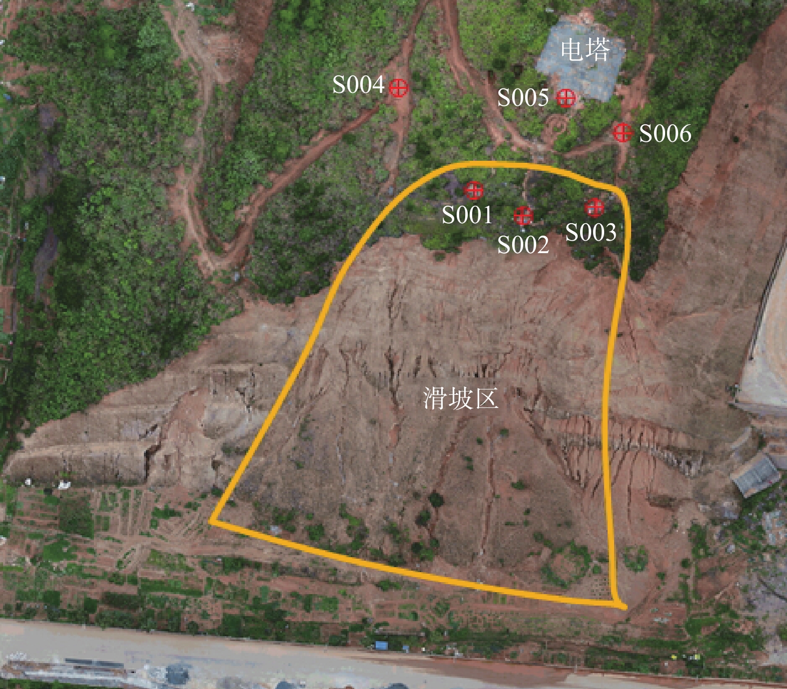
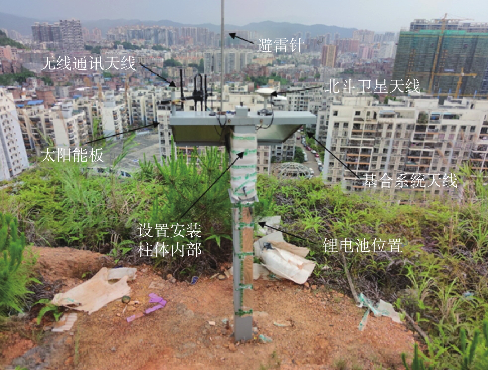
为提供全天候、全自动化、高精度变形监测服务,并最大限度降低空间环境因素对实时高精度定位的影响,基于数字调频广播(CDRadio)RTK(载波相位差分技术)边缘计算技术融合GNSS(全球卫星导航系统)核心解析算法,开发了具有自主知识产权、结构开放的“基于广播RTK边缘计算的北斗高精度地质灾害监测系统”,该系统能长时间稳定运行,并能满足功能性需求和非功能性需求在内的所有用户需要。以广西梧州市长洲区宝石园8号地块不稳定斜坡为例,通过分析2020年5—11月的监测数据表明:整个坡体处于蠕变阶段,坡顶前缘有向外侧蠕动且下沉的趋势,整个坡体有向东南方向倾斜发育的趋势。系统通过建立良好的系统信息交互平台,将系统形成的统计分析信息高速便捷地传递给用户,提高用户系统管理、决策、应用能力;充分挖掘系统数据资源,提供实时预报服务,提高信息采集、传输、处理、分析、预报的准确性、可靠性,全面提高地质灾害监测预警预报管理能力,更好地为各级管理部门的决策和指挥抢险救灾提供科学依据。
Abstract:To provide service of all-weather, full automation and high precision deformation monitoring and to furthest reduce the effects of space environment factors on the high precision real-time positioning, on the digital CDRadio edge of RTK GNSS core analytic computing technology fusion algorithm is used, and “the Beidou high-precision geological disaster monitoring system with edge calculation based on broadcasting RTK”is developed, which is characterized by the independent intellectual property rights and structure open. The system can run stably for a long time, and can satisfy the functional requirements and non-functional requirements of all users. Taking the unstable slope of block 8 in the Gemstone Garden in Changzhou District of Wuzhou as an example, the monitoring results from May to November 2020 are analyzed. The monitoring data show that the whole slope body is in the stage of slow development, and the front edge of the slope top has a tendency of peristatically moving and sinking. The whole slope body tends to develop towards the southeast direction. Through the establishment of a good system information interaction platform, the statistical analysis information formed by the system is transmitted to users in a high speed and convenient way, which effectively improves the users' system management, decision-making and application ability. It can fully mine the data resources of the system, provide real-time forecasting services, effectively improve the accuracy and reliability of information collection, transmission, processing, analysis and forecast, comprehensively improve the ability of geological disaster monitoring, early warning and forecast management, and better provide scientific basis for the decision-making and command of management departments at all levels in emergency rescue and disaster relief.
-

-
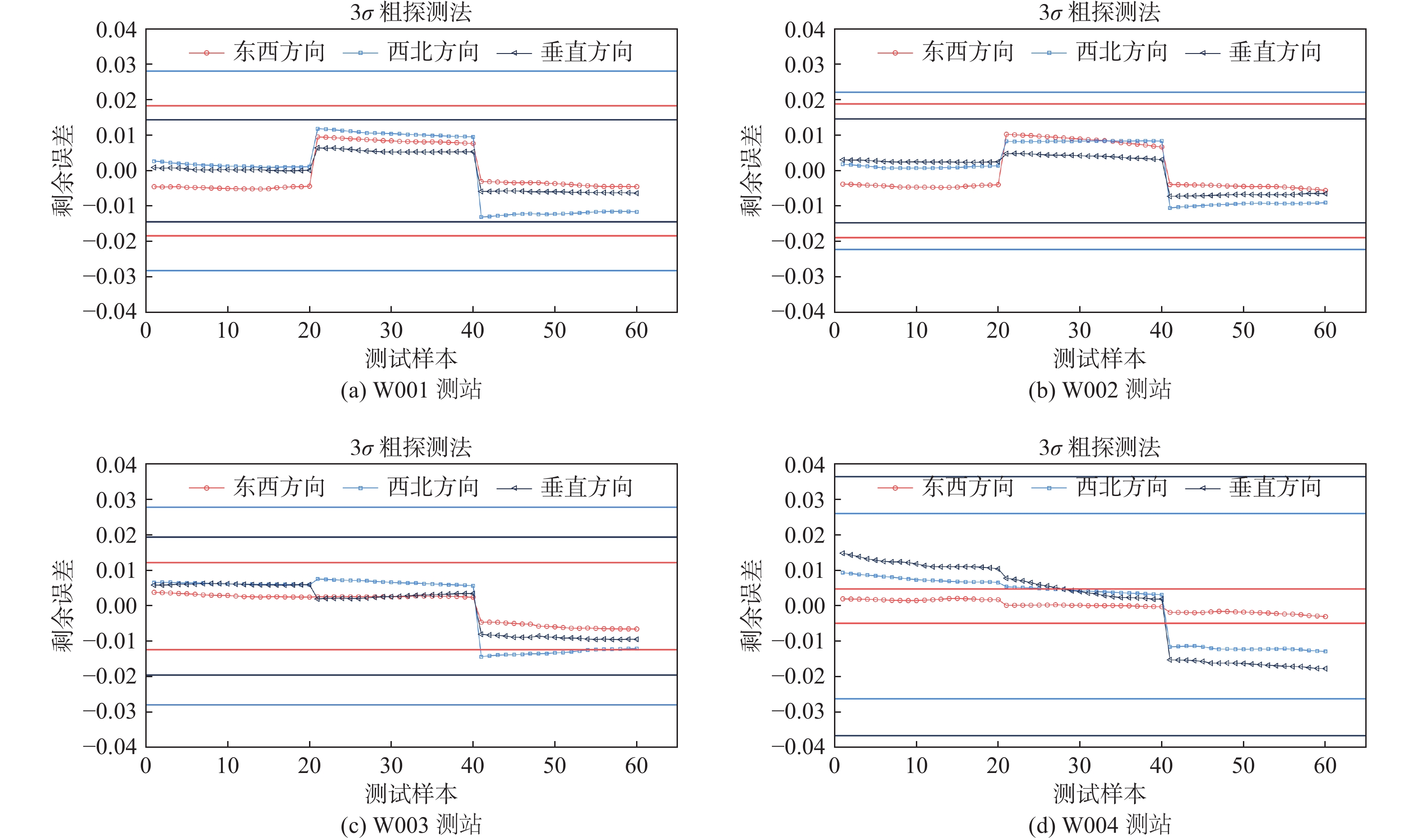
表 1 监测点解算状态表
Table 1. Solution state of the monitoring points
/% 监测点号 差分固定解 差分浮点解 单点定位解 W001 99.52 0.41 0.03 W002 99.97 0.02 0.01 W003 99.99 0.01 0.00 W004 99.99 0.01 0.00  下载: 导出CSV
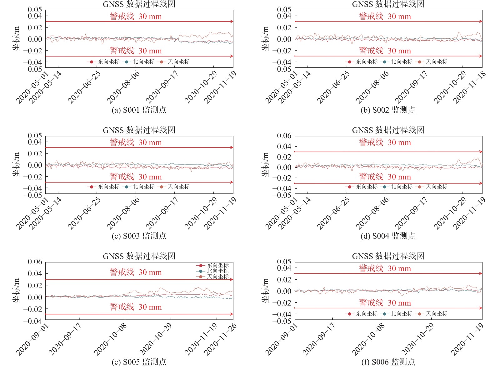
表 2 监测点标准差
Table 2. Standard deviations of the monitoring points
监测点号 东西方向 南北方向 高程方向 W001 0.0061 0.0094 0.0048 W002 0.0063 0.0074 0.0049 W003 0.0041 0.0093 0.0065 W004 0.0016 0.0087 0.0122
下载: 导出CSV
表 3 监测点变形监测结果
Table 3. The measurement results of the monitoring points
监测点号 水平位移 垂直位移 累计位移/
mm平均水平
位移/mm平均位移速率/
(mm·d−1)累计沉降/
mm累计沉降速率/
(mm·d−1)Δx Δy ΔHr ΔHr/d Δh Δh/d S001 2.27 2.59 3.44 0.02 3.28 0.02 S002 6.52 1.83 6.77 0.04 5.83 0.03 S003 4.58 6.14 7.66 0.04 9.85 0.05 S004 2.67 4.13 4.92 0.03 15.26 0.08 S005 3.23 1.08 3.41 0.03 12.57 0.14 S006 12.31 6.11 13.74 0.15 11.29 0.13
下载: 导出CSV
-
[1] 尚小伟. GNSS多基站变形监测系统技术研究与应用分析[D]. 成都: 西南交通大学, 2018.
SHANG Xiaowei. Technology research and application analysis of GNSS multi base-stations deformation monitoring system[D]. Chengdu: Southwest Jiaotong University, 2018. (in Chinese with English abstract)
[2] 董颖, 朱晓冬, 李媛, 等. 我国地质灾害监测技术方法[J]. 中国地质灾害与防治学报,2002,13(1):105 − 107. [DONG Ying, ZHU Xiaodong, LI Yuan, et al. Technical methods of geological hazard monitoring in China[J]. The Chinese Journal of Geological Hazard and Control,2002,13(1):105 − 107. (in Chinese) doi: 10.3969/j.issn.1003-8035.2002.01.025
[3] 韩子夜, 薛星桥. 地质灾害监测技术现状与发展趋势[J]. 中国地质灾害与防治学报,2005,16(3):138 − 141. [HAN Ziye, XUE Xingqiao. Status and development trend of monitoring technology for geological hazards[J]. The Chinese Journal of Geological Hazard and Control,2005,16(3):138 − 141. (in Chinese with English abstract) doi: 10.3969/j.issn.1003-8035.2005.03.032
[4] 杨文韬. GPS动态变形监测的单历元数据处理方法研究与软件实现[D]. 长沙: 中南大学, 2007.
YANG Wentao. Research and software implementation of single epoch metadata processing method for GPS dynamic deformation monitoring[D]. Changsha: Central South University, 2007. (in Chinese with English abstract)
[5] 吴悦, 曹修定, 胡景山. 应用于地质灾害监测的μC/OS-Ⅱ系统[J]. 中国地质灾害与防治学报,2008,19(3):130 − 133. [WU Yue, CAO Xiuding, HU Jingshan. Application of μC/OS-Ⅱ technology in the geological hazard moniforing[J]. The Chinese Journal of Geological Hazard and Control,2008,19(3):130 − 133. (in Chinese with English abstract) doi: 10.3969/j.issn.1003-8035.2008.03.028
[6] 徐文年. 基于CORS系统的变形监测方法研究与应用[D]. 沈阳: 东北大学, 2013.
XU Wennian. Methods research and application of deformation monitor based on CORS[D]. Shenyang: Northeastern University, 2013. (in Chinese with English abstract)
[7] OHNO H, NARUSE H, KIHARA M, et al. Industrial applications of the BOTDR optical fiber strain sensor[J]. Optical Fiber Technology,2001,7(1):45 − 64. doi: 10.1006/ofte.2000.0344
[8] CORSETTI M, FOSSATI F, MANUNTA M, et al. Advanced SBAS-DInSAR technique for controlling large civil infrastructures: an application to the genzano di Lucania dam[J]. Sensors (Basel, Switzerland),2018,18(7):E2371. doi: 10.3390/s18072371
[9] COOPER H M, ZHANG C Y, DAVIS S E, et al. Object-based correction of LiDAR DEMs using RTK-GPS data and machine learning modeling in the coastal Everglades[J]. Environmental Modelling & Software,2019,112:179 − 191.
[10] HADDAD Karim, MUNOZ Patricio, GALLO Enrico, et al. Application of Internet of Things technology for sound monitoring during large scale outdoor events[C]// INTER-NOISE and NOISE-CON Congress and Conference Proceedings, 2019.
[11] 朱永辉. 基于北斗卫星的地质灾害实时监测系统研究与应用[D]. 北京: 清华大学, 2010.
ZHU Yonghui. The real-time minitoring system for geological disasters based on compass satellite system[D]. Beijing: Tsinghua University, 2010. (in Chinese with English abstract)
[12] 曹修定, 阮俊, 展建设, 等. 滑坡的远程实时监测控制与数据传输[J]. 中国地质灾害与防治学报,2002,13(1):61 − 65. [CAO Xiuding, RUAN Jun, ZHAN Jianshe, et al. Long distance real time monitoring and control of landslide and data transmission[J]. The Chinese Journal of Geological Hazard and Control,2002,13(1):61 − 65. (in Chinese with English abstract) doi: 10.3969/j.issn.1003-8035.2002.01.015
[13] 曹庭泉. 基于深度学习的GNSS变形监测时间序列建模方法及应用研究[D]. 武汉: 武汉理工大学, 2019.
CAO Tingquan. Time series modeling method and application research of GNSS deformation monitoring based on deep learning[D]. Wuhan: Wuhan University of Technology, 2019. (in Chinese with English abstract)
[14] 张攀, 朱敦尧, 董红波. 北斗卫星导航系统在智慧城市建设中的应用探讨[J]. 全球定位系统,2013,38(4):71 − 74. [ZHANG Pan, ZHU Dunyao, DONG Hongbo. Discussion about the applications of BeiDou navigation satellite system in the construction of smart City[J]. GNSS World of China,2013,38(4):71 − 74. (in Chinese with English abstract) doi: 10.3969/j.issn.1008-9268.2013.04.017
[15] 董文, 潘建平, 阳振宇, 等. 高分二号卫星数据在地质灾害调查中的应用—以重庆万州区为例[J]. 中国地质灾害与防治学报,2019,30(1):106 − 111. [DONG Wen, PAN Jianping, YANG Zhenyu, et al. Application of GF-2 satellite data in geological hazard survey: a case study in Wanzhou District of Chongqing City[J]. The Chinese Journal of Geological Hazard and Control,2019,30(1):106 − 111. (in Chinese with English abstract)
[16] 刘宇. 地质灾害实时监测与信息管理集成系统关键技术研究[D]. 重庆: 重庆大学, 2015.
LIU Yu. Study on the key technology of geological hazard real-time monitor and information management integration system[D]. Chongqing: Chongqing University, 2015. (in Chinese with English abstract)
[17] 石爱军, 马娟, 齐安文, 等. 物联网技术在突发地质灾害应急响应中的应用研究[J]. 水文地质工程地质,2014,41(5):148 − 152. [SHI Aijun, MA Juan, QI Anwen, et al. Research on application of the Internet of Things (IOT) platform of geological disaster emergency response[J]. Hydrogeology & Engineering Geology,2014,41(5):148 − 152. (in Chinese with English abstract)
[18] 陈其针, 仲平, 张贤, 等. 构建中国自然灾害防灾减灾新体系[J]. 水文地质工程地质,2020,47(4):1 − 4. [CHEN Qizhen, ZHONG Ping, ZHANG Xian, et al. Establishment of an innovative system of natural disaster prevention and mitigation in China[J]. Hydrogeology & Engineering Geology,2020,47(4):1 − 4. (in Chinese with English abstract)
[19] 刘晓茹. 配电自动化中通信系统的设计与评价方法的研究[D]. 北京: 华北电力大学(北京), 2009.
LIU Xiaoru. Study on communication system plan and evaluation method in the distribution automation system[D]. Beijing: North China Electric Power University, 2009. (in Chinese with English abstract)
-
图(5)
表(3)
计量
- 文章访问数: 2284
- PDF下载数: 108
- 施引文献: 0