Application of GB-InSAR in deformation monitoring of huge landslide in reservoir area
-
摘要:
水电站库区特大型滑坡的稳定性对于水电站坝工结构及周边人民生命财产安全具有重要影响,对该类滑坡稳定性及变形趋势进行大范围实时精确观测可为滑坡提供可靠的预警和治理信息,具有十分重要的意义。水电站库区滑坡传统监测方法主要以GNSS监测,全站仪监测等为主,本研究将国产先进的地基干涉合成孔径雷达系统LKR-05-KU-S100,应用于澜沧江大华桥水电站沧江桥—营盘滑坡和大华滑坡的监测。现场监测试验表明,该系统精度较高,可进行远距离、全天时、全天候、大范围监测,对于大型及特大型滑坡的监测具有独特的优势和广阔的应用前景。
-
关键词:
- GB-InSAR /
- 差分干涉测量 /
- 特大型滑坡 /
- 变形监测 /
- LKR-05-KU-S100
Abstract:The stability of large-scale landslide in the reservoir area of hydropower station has an important impact on the safety of dam structure and surrounding people's life and property. Large-scale real-time accurate observation of the stability and deformation trend of this type of landslide can provide reliable early warning and control information for the landslide, which is of great significance. The traditional monitoring methods of landslide in the reservoir area of hydropower station are mainly GNSS monitoring and total station monitoring. In this study, the advanced GB-InSAR system LKR-05-KU-S100 is applied to the monitoring of Cangjiangqiao-Yingpan landslide and Dahua landslide of Dahuaqiao hydropower station on Lancang River. Field monitoring tests show that the system has high precision, and it can carry out long-distance, all-day, all-weather, and large-scale monitoring. It has unique advantages and broad application prospects for the monitoring of large and super-large landslides.
-
Key words:
- GB-InSAR /
- differential interferometry /
- huge landslide /
- deformation monitoring /
- LKR-05-KU-S100
-

-
表 1 雷达基本参数表
Table 1. Radar basic parameter table
雷达组成 参数名称 参数取值 雷达控制单元 信号频段 Ku 信号类型 SFCW 孔径类型 合成孔径 天线 增益 18 dBi 极化方式 VV 主瓣-3 dB角宽 75°H/90°V 表 2 LKR-05-KU-S100系统基本参数
Table 2. Basic parameters of LKR-05-KU-S100 system
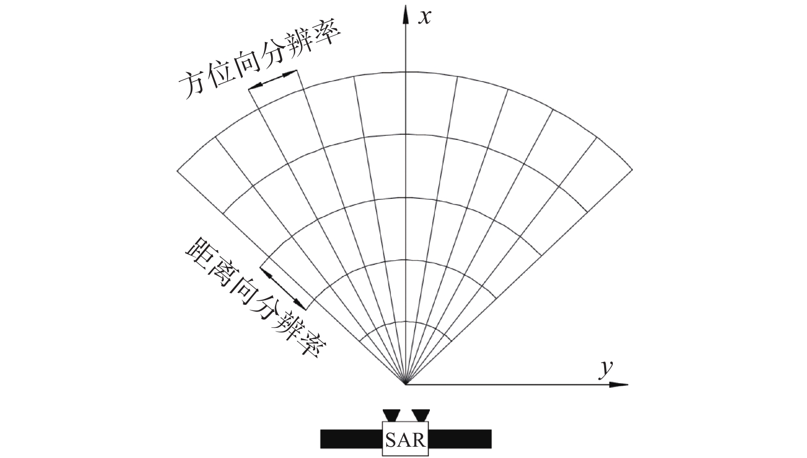
参数名称 参数取值 分辨率 距离分辨率:0.3 m 方位向:4 mrad(可定制) 监测距离/m 10~4000 监测精度/mm 0.1 工作环境/°C −25~60 软件 软件数据接口开放,界面简易,操作方便 可定制性 可实现多源数据融合 -
[1] 王自高. 西南水利水电工程地质灾害问题与预防措施研究[M]. 北京: 中国水利水电出版社, 2013.
WANG Zigao. Study on geological hazards and preventive measures of water conservancy and hydropower projects in Southwest China[M]. Beijing: China Water&Power Press, 2013. (in Chinese)
[2] 王自高, 何伟, 王昆. 水利水电工程中地质灾害预防与地质环境保护对策[J]. 中国地质灾害与防治学报,2012,23(2):70 − 74. [WANG Zigao, HE wei, WANG kun. Geological hazard prevention and environment protection for water conservancy and hydropower engineering[J]. The Chinese Journal of Geological Hazard and Control,2012,23(2):70 − 74. (in Chinese with English abstract) doi: 10.3969/j.issn.1003-8035.2012.02.015
[3] 吴星辉, 马海涛, 张杰. 地基合成孔径雷达的发展现状及应用[J]. 武汉大学学报(信息科学版),2019,44(7):1073 − 1081. [WU Xinghui, MA Haitao, ZHANG Jie. Development status and application of ground-based synthetic aperture radar[J]. Geomatics and Information Science of Wuhan University,2019,44(7):1073 − 1081. (in Chinese with English abstract)
[4] 张伟琪, 王利, 曲轩宇. 基于测量机器人的黄土滑坡变形监测及结果分析[J]. 测绘工程,2019,28(3):66 − 69. [ZHANG Weiqi, WANG Li, QU Xuanyu. Deformation monitoring and result analysis of loess landslide based on geo-robot[J]. Engineering of Surveying and Mapping,2019,28(3):66 − 69. (in Chinese with English abstract)
[5] 于欢欢, 徐亚富, 谢洪波. 基于三维激光扫描技术的边坡变形监测应用研究[J]. 中州煤炭,2015(12):111 − 113. [YU Huanhuan, XU Yafu, XIE Hongbo. Application of slope deformation monitoring based on Three-Dimensional laser scanning technology[J]. Zhongzhou Coal,2015(12):111 − 113. (in Chinese with English abstract) doi: 10.3969/j.issn.1003-0506.2015.12.035
[6] 刘国祥, 张波, 张瑞, 等. 联合卫星SAR和地基SAR的海螺沟冰川动态变化及次生滑坡灾害监测[J]. 武汉大学学报(信息科学版),2019,44(7):980 − 995. [LIU Guoxiang, ZHANG Bo, ZHANG Rui, et al. Monitoring dynamics of Hailuogou glacier and the secondary landslide disaster based on combination of satellite SAR and ground-based SAR[J]. Geomatics and Information Science of Wuhan University,2019,44(7):980 − 995. (in Chinese with English abstract)
[7] 蒋留兵, 杨凯, 车俐. 地基合成孔径雷达对目标三维形变的监测[J]. 测绘通报,2020(3):35 − 38. [JIANG Liubing, YANG Kai, CHE Li. Monitoring of 3D deformation of target by ground-based synthetic aperture radar[J]. Bulletin of Surveying and Mapping,2020(3):35 − 38. (in Chinese with English abstract)
[8] 刘斌, 葛大庆, 张玲, 等. 地基雷达干涉测量技术在滑坡灾后稳定性评估中的应用[J]. 大地测量与地球动力学,2016,36(8):674 − 677. [LIU Bin, GE Daqing, ZHANG Ling, et al. Application of monitoring stability after landslide based on ground-based InSAR[J]. Journal of Geodesy and Geodynamics,2016,36(8):674 − 677. (in Chinese with English abstract)
[9] 邱志伟, 岳建平, 汪学琴. 地基雷达系统IBIS-L在大坝变形监测中的应用[J]. 长江科学院院报,2014,31(10):104 − 107. [QIU Zhiwei, YUE Jianping, WANG Xueqin. Application of ground-based radar system IBIS-L to dam deformation analysis[J]. Journal of Yangtze River Scientific Research Institute,2014,31(10):104 − 107. (in Chinese with English abstract) doi: 10.3969/j.issn.1001-5485.2014.10.015
[10] 邢诚, 韩贤权, 周校, 等. 地基合成孔径雷达大坝监测应用研究[J]. 长江科学院院报,2014,31(7):128 − 134. [XING Cheng, HAN Xianquan, ZHOU Xiao, et al. Application of GB-SAR to dam monitoring[J]. Journal of Yangtze River Scientific Research Institute,2014,31(7):128 − 134. (in Chinese with English abstract) doi: 10.3969/j.issn.1001-5485.2014.07.025
[11] 张昊宇, 周克勤, 宋亚腾, 等. 基于新型FMCW地基合成孔径雷达的大坝变形监测[J]. 长江科学院院报,2017,34(12):33 − 37. [ZHANG Haoyu, ZHOU Keqin, SONG Yateng, et al. A novel FMCW GB-SAR based dam deformation monitoring[J]. Journal of Yangtze River Scientific Research Institute,2017,34(12):33 − 37. (in Chinese with English abstract) doi: 10.11988/ckyyb.20160869
[12] 李如仁, 杨震, 余博. GB-InSAR集成GIS的露天煤矿边坡变形监测[J]. 测绘通报,2017(5):26 − 30. [LI Ruren, YANG Zhen, YU Bo. Slope deformation mon-itoring of open pit coal mine by GIS integrated GB-InSAR[J]. Bulletin of Surveying and Mapping,2017(5):26 − 30. (in Chinese with English abstract)
[13] 林德才, 马海涛, 宋宝宏. 边坡雷达在滑坡应急救援行动中的应用[J]. 中国安全生产科学技术,2016,12(增刊1):284 − 289. [LIN Decai, MA Haitao, SONG Baohong. Application of slope radar in emergency rescue of landslide[J]. Journal of Safety Science and Technology,2016,12(Sup1):284 − 289. (in Chinese with English abstract)
[14] 李翔宇, 雷添杰, 陈文晋, 等. 基于地基雷达干涉测量技术的大坝边坡形变监测及应用[J]. 安徽农业科学,2020,48(9):221 − 225. [LI Xiangyu, LEI Tianjie, CHEN Wenjin, et al. Deformation monitoring and application of dam slope based on ground-based radar interferometry[J]. Journal of Anhui Agricultural Sciences,2020,48(9):221 − 225. (in Chinese with English abstract)
[15] LUO Y, SONG H, WANG R, et al. Arc FMCW SAR and applications in ground monitoring[J]. IEEE Transactions on Geoscience and Remote Sensing,2014,52(9):5989 − 5998. doi: 10.1109/TGRS.2014.2325905
[16] 江桥, 彭军还, 杨红磊, 等. 改进小基线集技术的GB-InSAR铁路边坡监测[J]. 测绘科学,2017,42(12):140 − 145. [JIANG Qiao, PENG Junhuan, YANG Honglei, et al. GB-InSAR railway slope mon-itoring of improved small baseline subset technology[J]. Science of Surveying and Mapping,2017,42(12):140 − 145. (in Chinese with English abstract)
[17] 郭鹏, 张昊宇, 陈力, 等. 新型FMCW地基合成孔径雷达在大桥变形监测中的应用[J]. 测绘通报,2017(6):94 − 97. [GUO Peng, ZHANG Haoyu, CHEN Li, et al. A novel FMCW GB-SAR based bridge deformation measurement campaign[J]. Bulletin of Surveying and Mapping,2017(6):94 − 97. (in Chinese with English abstract)
[18] 姜春生, 汪剑, 何玉童. 地基合成孔径雷达在大坝安全监测中的应用[J]. 中国地质灾害与防治学报,2017,28(2):146 − 149. [JIANG Chunsheng, WANG Jian, HE Yutong. Application of ground synthetic aperture radar in dam safety monitoring[J]. The Chinese Journal of Geological Hazard and Control,2017,28(2):146 − 149. (in Chinese with English abstract)
[19] 杨红磊, 彭军还, 崔洪曜. GB-InSAR监测大型露天矿边坡形变[J]. 地球物理学进展,2012,27(4):1804 − 1811. [YANG Honglei, PENG Junhuan, CUI Hongyao. Slope of large-scale open-pit mine monitoring deformations by using ground-based interferometry[J]. Progress in Geophysics,2012,27(4):1804 − 1811. (in Chinese with English abstract) doi: 10.6038/j.issn.1004-2903.2012.04.064
[20] 孙凯辉, 张永辉, 杨须宁. 大华桥水电站库区岸坡类型分析及塌岸预测[J]. 资源环境与工程,2016,30(3):369 − 373. [SUN Kaihui, ZHANG Yonghui, YANG Xuning. Type analysis of bank slope and prediction of bank collapse for reservoir area of Dahuaqiao hydropower station[J]. Resources Environment & Engineering,2016,30(3):369 − 373. (in Chinese with English abstract)
[21] 罗冠枝, 高文伟, 王国卫, 等. 库岸斜坡失稳及其涌浪灾害风险分析[J]. 中国地质灾害与防治学报,2020,31(1):8 − 17. [LUO Guanzhi, GAO Wenwei, WANG Guowei, et al. Risk analysis of surge disaster and slope instability on reservoir bank[J]. The Chinese Journal of Geological Hazard and Control,2020,31(1):8 − 17. (in Chinese with English abstract)
[22] 梁桂星, 覃小群, 崔亚莉, 等. 分布式水文模型在岩溶地区的改进与应用研究[J]. 水文地质工程地质,2020,47(2):60 − 67. [LIANG Guixing, QIN Xiaoqun, CUI Yali, et al. Improvement and application of a distributed hydrological model in karst regions[J]. Hydrogeology & Engineering Geology,2020,47(2):60 − 67. (in Chinese with English abstract)
-


 下载:
下载:


