

The February 7 of 2021 glacier-rock avalanche and the outburst flooding disaster chain in Chamoli, India
-
摘要:
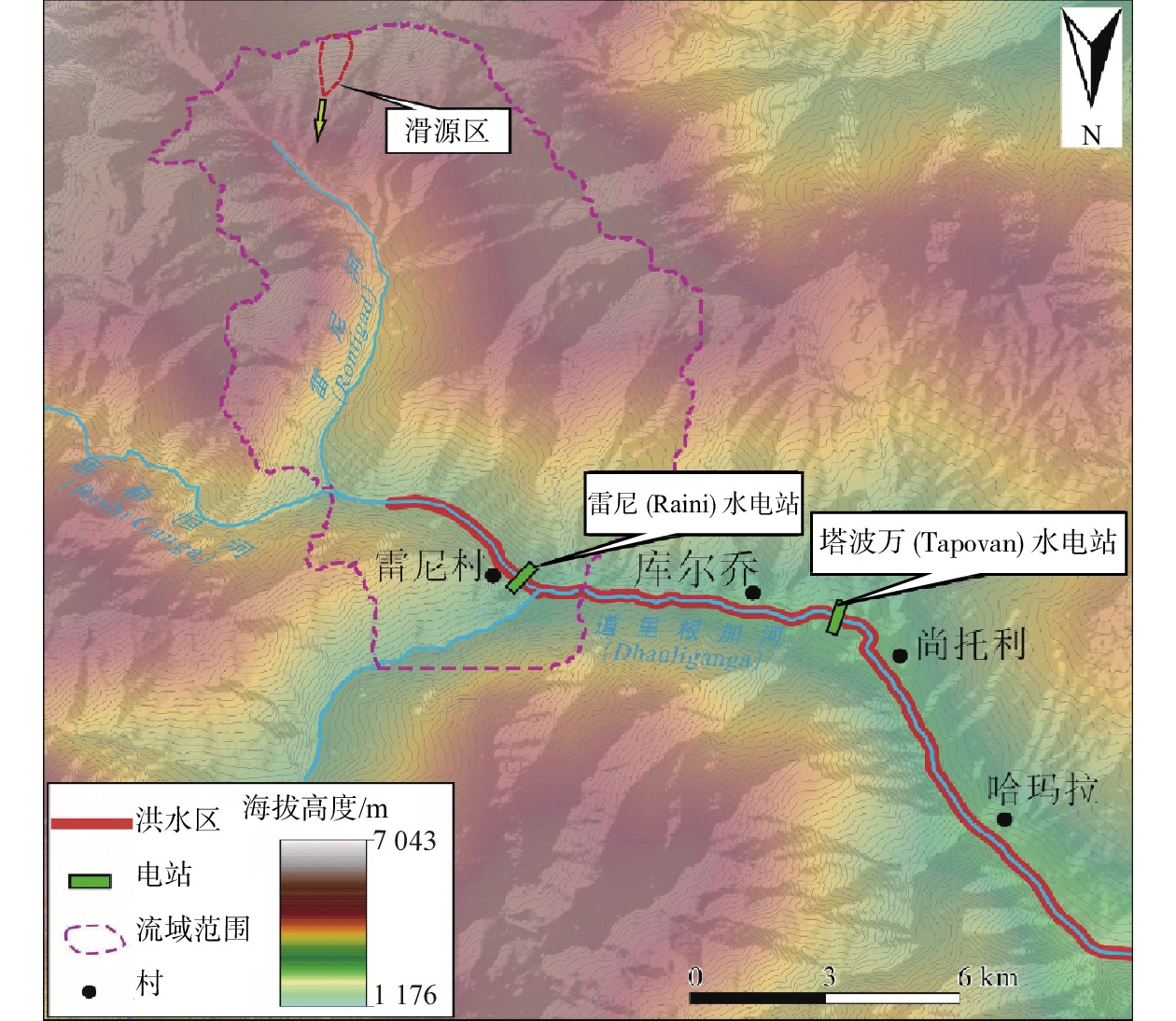
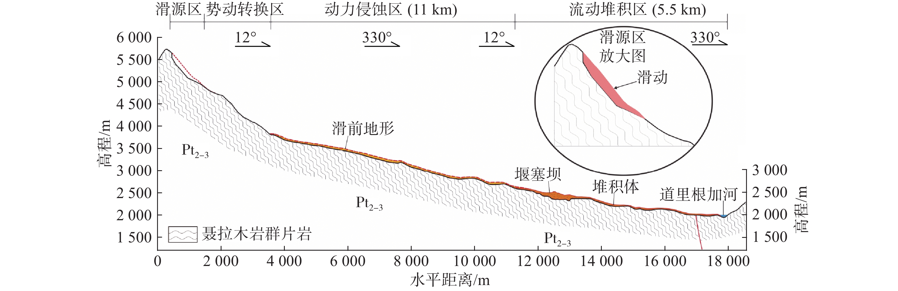
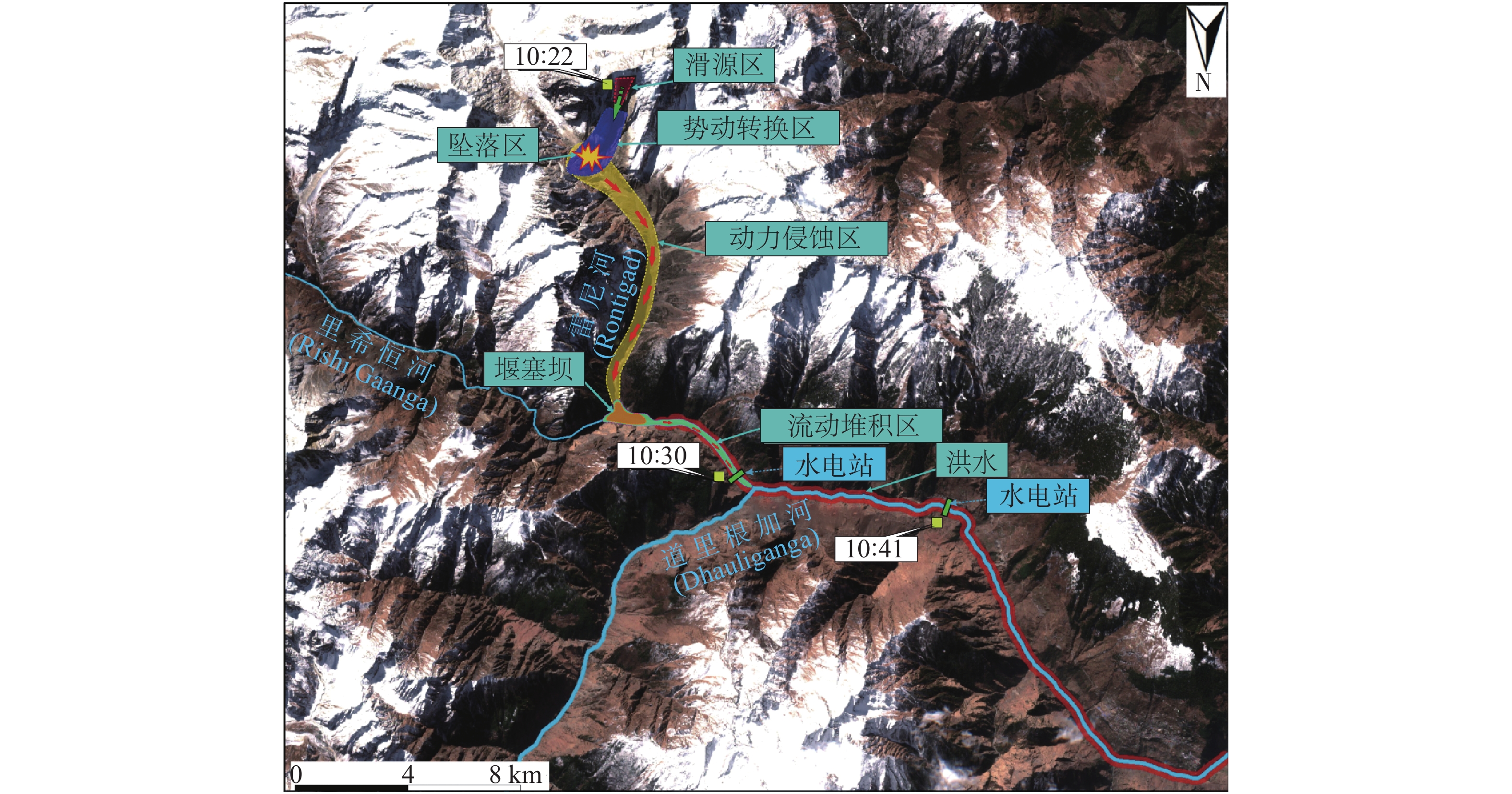
2021年2月7日,印度查莫利北部里希恒河发生高位冰岩山崩堵江溃决洪水灾害链,造成下游20 km外的水电站和桥梁设施破坏,死亡、失踪人口近200人。文章运用多期高分辨率遥感影像,对比分析了印度查莫利里希恒河流域高位冰岩山崩灾害发生前后滑源区、堆积区变化特征,初步探讨了山崩的运动过程。结果显示:2013年以前,崩滑体蠕滑位移量较小,其表面冰雪覆盖层裂缝发育不明显;2013—2017年,崩滑体蠕滑位移量显著增加,冰雪覆盖层可见多达62处大小不一的冰裂缝,最长513 m;2021年2月5日卫星影像显示这些冰裂缝已发生连接、贯通,最大宽度为15 m,并于2月7日发生失稳、破坏。据滑后遥感影像,该崩滑体由4组不同方向的大型结构面切割而成,面积约0.32 km2,平均厚度约为70 m,体积约23×106 m3。崩滑体失稳、解体后以碎屑流沿沟谷向下高速运动,受地形拦挡,部分碎屑颗粒在地形急变带堆积且形成堰塞坝。堰塞坝体溃决后,形成山洪灾害。
Abstract:On 7 Feb 2021, a high-location glacier-rock avalanche and dammed the river, and late caused outburst flooding disaster on the Rich Ganges River in northern Chamoli, India, that destroyed hydropower stations and bridge facilities more than 20 kilometers downstream, and claimed nearly 200 deaths. This paper uses multi-period high-resolution remote sensing images to compare and analyze the characteristics of the landslide source area and accumulation area before and after the high-location ice rock landslide disaster in the Ganges River Basin of Chamoli, India, and preliminarily discuss the movement process of the landslide. The results show that before 2013, the creep displacement of the avalanche landslide was small, and the cracks in the ice and snow cover on the surface were not obvious. From 2013 to 2017, the creep displacement of avalanche landslides increased significantly, and as many as 62 ice cracks of various sizes were visible in the ice and snow cover, with the longest being 513 m. Satellite images on February 5, 2021 showed that these ice cracks had been connected and penetrated, with a maximum width of 15 m, and they were unstable and damaged on February 7. According to the post-sliding remote sensing image, the collapsed landslide was cut from 4 sets of large structural surfaces in different directions, with an area of about 0.32 km2, an average thickness of about 70 m, and a volume of about 23×106 m3. The collapsed landslide body loses stability and disintegrates and moves down the valley with a debris flow at high speed. Due to terrain blocking, some debris particles accumulate in the rapid terrain change zone and form a barrier dam. After the barrier dam body breaks, a mountain torrent disaster is formed.
-

-
[1] DESHMUKH A, OHE N, HASTAK M. Impact of flood damaged critical infrastructure on communities and industries[J]. Built Environment Project and Asset Management,2011,1(2):156 − 175. doi: 10.1108/20441241111180415
[2] GRUBER S, HAEBERLI W. Permafrost in steep bedrock slopes and its temperature-related destabilization following climate change[J]. Journal of Geophysical Research,2007,112:1 − 10.
[3] CHAUHAN S, SHARMA M, ARORAM K. Landslide Susceptibility Zonation Of The Chamoli region, Garhwal Himalayas, using logistic regression model[J]. Landslide,2010,(7):411 − 423. doi: 10.1007/s10346-010-0202-3
[4] SARAF A K. Cover: IRS-1C-PAN depicts Chamoli earthquake induced landslides in Garhwal Himalayas, India[J]. International Journal of Remote Sensing,2000,21: 2345 − 2352.
[5] SANGEETA B, MAHESHWARI K. Earthquake-Induced Landslide Hazard Assessment of Chamoli, District Uttarakhand Using Relative Frequency Ratio Method[J]. Indian Geotech Journal,2019,49(1):108 − 123. doi: 10.1007/s40098-018-0334-2
[6] SANGEETA B, MAHESHWARI K, KANUNGO P D. GIS-based pre-and post-earthquake landslie susceptibility zonation with reference to 1999 Chamoli earthquake[J]. J Earth Syst,2020,129(55):1 − 20.
[7] 殷跃平. 西藏波密易贡高速巨型滑坡特征及减灾研究[J]. 水文地质工程地质,2000,27(4):8 − 11. [YIN Yueping. Research on the characteristics and disaster mitigation of giant landslides on the Bomi-Yigong Expressway in Xizang[J]. Hydrogeology & Engineering Geology,2000,27(4):8 − 11. (in Chinese with English abstract) doi: 10.3969/j.issn.1000-3665.2000.04.003
[8] 童立强, 涂杰楠, 裴丽鑫, 等. 雅鲁藏布江加拉白垒峰色东普流域频繁发生碎屑流事件初步探讨[J]. 工程地质学报,2018,26(6):1552 − 1561. [TONG Liqiang, TU Jienan, PEI Lixin, et al. Preliminary discussion on the frequent occurrence of detrital flow events in the Sedongpu watershed of the Karabai Peak of the Yarlung Zangbo River[J]. Journal of Engineering Geology,2018,26(6):1552 − 1561. (in Chinese with English abstract)
[9] 殷跃平, 王文沛, 张楠, 等. 强震区高位滑坡远程灾害特征研究—以四川茂县新磨滑坡为例[J]. 中国地质,2017,44(5):827 − 841. [YIN Yueping, WANG Wenpei, ZHANG Nan, et al. Study on the characteristics of remote disasters of high-location landslides in strong earthquake areas:Taking Xinmo landslide in Maoxian County, Sichuan Province as an example[J]. Chinese Geology,2017,44(5):827 − 841. (in Chinese with English abstract) doi: 10.12029/gc20170501
[10] HEIM A, GANSSER A. Central Himalayas-Geological obsevratons of the Swiss expedition[J]. Science Naturelles,1939,73:1 − 245.
[11] 崔军文, 朱红, 武长得, 等. 亚东-格尔木CGT, 青藏高原岩石圈变形及其动力学[M]. 北京: 地质出版社, 1992: 1−164.
CUI Junwen, ZHU Hong, WU Changde, et al. Yadong-Golmud CGT, Lithospheric deformation and dynamics of the Qinghai-Xizang Plateau[M]. Beijing: Geological Publishing House, 1992: 1−164. (in Chinese)
[12] 高杨, 贺凯, 李壮, 等. 西南岩溶山区特大滑坡成灾类型及动力学分析[J]. 水文地质工程地质,2020,47(4):14 − 23. [GAO Yang, HE Kai, LI Zhuang, et al. An analysis of disaster types and dynamics of landslides in the southwest karst mountain areas[J]. Hydrogeology & Engineering Geology,2020,47(4):14 − 23. (in Chinese with English abstract)
[13] 李滨, 殷跃平, 高杨, 等. 西南岩溶山区大型崩滑灾害研究的关键问题[J]. 水文地质工程地质,2020,47(4):5 − 13. [LI Bin, YIN Yueping, GAO Yang, et al. Critical issues in rock avalanches in the karst mountain areas of southwest China[J]. Hydrogeology & Engineering Geology,2020,47(4):5 − 13. (in Chinese with English abstract)
[14] 许世民, 殷跃平, 邢爱国, 等. 基于地震信号的贵州纳雍崩塌-碎屑流运动特征分析[J]. 中国地质灾害与防治学报,2020,31(2):1 − 8. [XU Shimin, YIN Yueping, XING Aiguo, et al. Characteristic analysis of the Nayong rock avalanche’ skinematics based on seismic signals[J]. The Chinese Journal of Geological Hazard and Control,2020,31(2):1 − 8. (in Chinese with English abstract)
[15] 戴兴建, 殷跃平, 邢爱国. 易贡滑坡-碎屑流-堰塞坝溃坝链生灾害全过程模拟与动态特征分析[J]. 中国地质灾害与防治学报,2019,30(5):1 − 8. [DAI Xingjian, YIN Yueping, XING Aiguo. Simulation and dynamic analysis of Yigong rockslide debris avalanche dam breaking disaster chain[J]. The Chinese Journal of Geological Hazard and Control,2019,30(5):1 − 8. (in Chinese with English abstract)
-
 下载:
下载:


图(9)
计量
- 文章访问数: 3737
- PDF下载数: 412
- 施引文献: 0