

Time series InSAR surface deformation monitoring in extremely difficult area based on track refining control points selection
-
摘要:
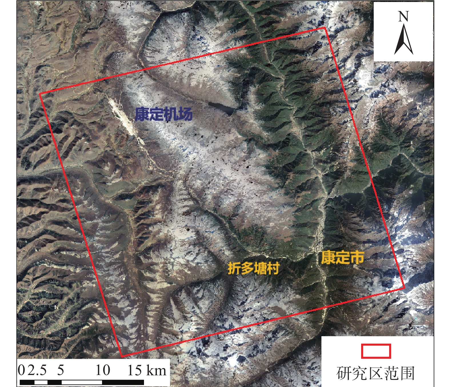
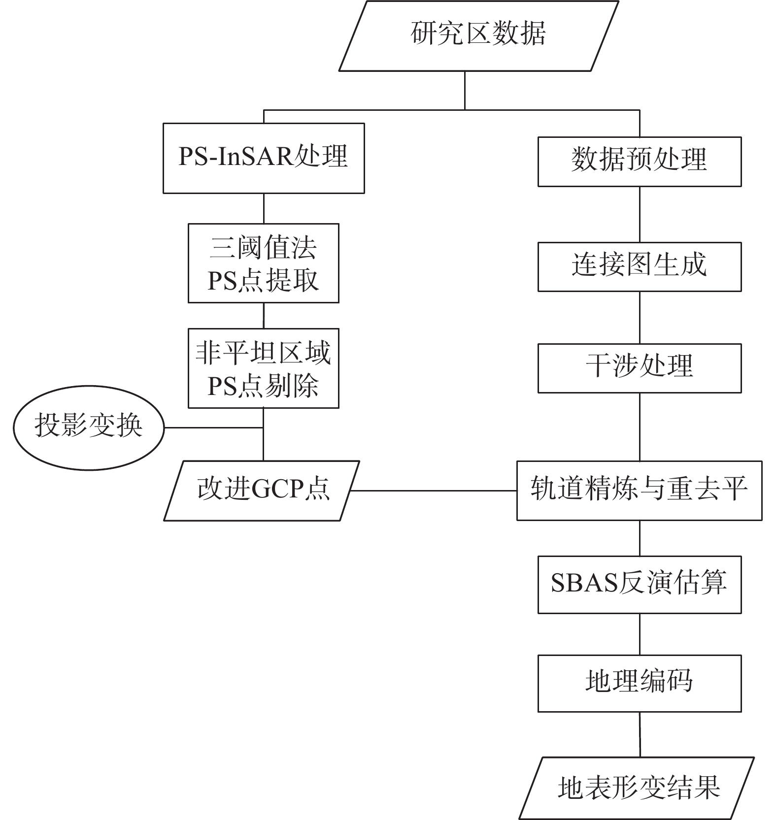
极艰险区域具有地形起伏极大、地理环境复杂和永久散射体稀少的特点,为此文章设计了一种改进的SBAS-InSAR技术进行地表形变监测。文章先从相干性、振幅离差指数、形变速率三个方面获得候选的永久性散射体点,之后辅以光学影像精选出最终的永久性散射体点,将其作为轨道精炼控制点引入SBAS-InSAR解算过程,最终完成了研究区的地表形变监测。通过对比分析常规的PS-InSAR技术与SBAS-InSAR技术,该技术在极艰险区域具有良好的应用价值。
-
关键词:
- 轨道精炼控制点 /
- SBAS-InSAR /
- 极艰险区域 /
- 地表形变监测
Abstract:The extremely difficult area has the characteristics of extremely rugged terrain, complex geographical environment and sparse permanent scatterers. Therefore, an improved SBAS-InSAR technology is designed to monitor the surface deformation. In this paper, the candidate permanent scatterers are obtained from the coherence, amplitude dispersion index and deformation rate, and then the final permanent scatterers are selected by optical images, which are introduced into the SBAS-InSAR calculation process as orbit refining control points, and finally the surface deformation monitoring in the study area is completed. By comparing and analyzing the conventional PS-InSAR technology and SBAS-InSAR technology, the technology has good application value in extremely difficult areas.
-

-
表 1 两种时序InSAR技术的形变速率统计
Table 1. Deformation rate statistics of two time series InSAR techniques
方法 最小值 最大值 均值 标准差 改进前的
SBAS-InSAR−154.352951 140.393066 −1.208922 9.224748 改进后的
SBAS-InSAR−153.044235 141.006891 −1.099689 9.172168  下载: 导出CSV
表 2 两种时序InSAR技术的形变速率精度统计
Table 2. Deformation rate accuracy statistics of two time series InSAR techniques
方法 最小值 最大值 均值 标准差 改进前的
SBAS-InSAR0.143982 17.381382 3.851148 1.401882 改进后的
SBAS-InSAR0.142428 16.711776 3.091360 1.279466
下载: 导出CSV
-
[1] 王如意. 基于SBAS-InSAR的高分辨率地面沉降监测技术研究[D]. 北京: 中国地质大学(北京), 2015.
WANG Ruyi. The study of land subsidence monitoring technology based on SBAS-InSAR with high resolution[D]. Beijing: China University of Geosciences, 2015. (in Chinese with English abstract)
[2] 李达, 邓喀中, 高晓雄, 等. 基于SBAS-InSAR的矿区地表沉降监测与分析[J]. 武汉大学学报(信息科学版),2018,43(10):1531 − 1537. [LI Da, DENG Kazhong, GAO Xiaoxiong, et al. Monitoring and analysis of surface subsidence in mining area based on SBAS-InSAR[J]. Geomatics and Information Science of Wuhan University,2018,43(10):1531 − 1537. (in Chinese with English abstract)
[3] ROSEN P A, HENSLEY S, JOUGHIN I R, et al. Synthetic aperture radar interferometry[J]. Proceedings of the IEEE,2000,88(3):333 − 382. doi: 10.1109/5.838084
[4] SIMONS M, ROSEN P A. Interferometric synthetic aperture radar geodesy[M]//Treatise on Geophysics. Amsterdam: Elsevier, 2007: 391-446.
[5] 周超. 集成时间序列InSAR技术的滑坡早期识别与预测研究[D]. 武汉: 中国地质大学, 2018.
ZHOU Chao. Landslide identification and prediction with the application of time series InSAR[D]. Wuhan: China University of Geosciences, 2018. (in Chinese with English abstract)
[6] FERRETTI A, PRATI C, ROCCA F. Nonlinear subsidence rate estimation using permanent scatterers in differential SAR interferometry[J]. IEEE Transactions on Geoscience and Remote Sensing,2000,38(5):2202 − 2212. doi: 10.1109/36.868878
[7] BERARDINO P, FORNARO G, LANARI R, et al. A new algorithm for surface deformation monitoring based on small baseline differential SAR interferograms[J]. IEEE Transactions on Geoscience and Remote Sensing,2002,40(11):2375 − 2383. doi: 10.1109/TGRS.2002.803792
[8] 白泽朝, 靳国旺, 张红敏, 等. 天津地区Sentinel-1A雷达影像PSInSAR地面沉降监测[J]. 测绘科学技术学报,2017,34(3):283 − 288. [BAI Zechao, JIN Guowang, ZHANG Hongmin, et al. Subsidence monitoring of Tianjin using PSIn SAR technique with sentinel-1A[J]. Journal of Geomatics Science and Technology,2017,34(3):283 − 288. (in Chinese with English abstract)
[9] 何平. 时序InSAR的误差分析及应用研究[D]. 武汉: 武汉大学, 2014.
HE Ping. Error analysis and surface deformation application of time series InSAR[D]. Wuhan: Wuhan University, 2014. (in Chinese with English abstract)
[10] 陈玺. SBAS-InSAR技术在秦州区地表形变监测与滑坡敏感性评价中的应用研究[D]. 兰州: 兰州大学, 2018.
CHEN Xi. Detecting ground deformation and assessing landslide susceptibility in Qinzhou district based on SBAS-InSAR technique[D]. Lanzhou: Lanzhou University, 2018. (in Chinese with English abstract)
[11] LIU X J, ZHAO C Y, ZHANG Q, et al. Characterizing and monitoring ground settlement of marine reclamation land of Xiamen new airport, China with sentinel-1 SAR datasets[J]. Remote Sensing,2019,11(5):585. doi: 10.3390/rs11050585
[12] 潘光永, 陶秋香, 陈洋, 等. 基于SBAS-InSAR的山东济阳矿区沉降监测与分析[J]. 中国地质灾害与防治学报,2020,31(4):100 − 106. [PAN Guangyong, TAO Qiuxiang, CHEN Yang, et al. Monitoring and analysis of sedimentation in Jiyang mining area of Shandong Province based on SBAS-InSAR[J]. The Chinese Journal of Geological Hazard and Control,2020,31(4):100 − 106. (in Chinese with English abstract)
[13] 王舜瑶, 卢小平, 刘晓帮, 等. 一种顾及永久散射体的SBAS InSAR时序地表沉降提取方法[J]. 测绘通报,2019(2):58 − 62. [WANG Shunyao, LU Xiaoping, LIU Xiaobang, et al. A SBAS InSAR time series ground deformation extraction approach considering permanent scatterers[J]. Bulletin of Surveying and Mapping,2019(2):58 − 62. (in Chinese with English abstract)
[14] FERRETTI A, PRATI C, ROCCA F. Permanent scatterers in SAR interferometry[J]. IEEE Transactions on Geoscience and Remote Sensing,2001,39(1):8 − 20. doi: 10.1109/36.898661
[15] 丁伟. PSInSAR点目标提取及相位解缠技术研究[D]. 长沙: 中南大学, 2011.
DING Wei. Study of PSInSAR on the technique of points selection and phase unwrapping[D]. Changsha: Central South University, 2011. (in Chinese with English abstract)
[16] 刘路遥. 基于分布式目标雷达干涉测量的滑坡形变监测[D]. 成都: 西南交通大学, 2018.
LIU Luyao. Deformation monitoring of landslide based on distributed scatter interferometric synthetic aperture radar[D]. Chengdu: Southwest Jiaotong University, 2018. (in Chinese with English abstract)
-


图(8)
表(2)
计量
- 文章访问数: 2643
- PDF下载数: 174
- 施引文献: 0