

Landslide risk assessment in Nanping City based on artificial neural networks model
-
摘要:
滑坡灾害持续影响着人民生命财产安全和地区社会经济可持续发展,滑坡危险性评价能够为防灾减灾和区域规划提供有效的理论依据。以福建省南平市为研究区,区内1711个历史滑坡灾害点,选择高程、坡度、坡向、曲率、地质岩性、土壤类型、降雨、水系、土地利用类型、公路和铁路共11个影响因子构成基本评价体系。使用Spearman相关系数对各因子进行共线性分析。基于1711个滑坡样本和1711个随机选取的非滑坡样本数据,利用人工神经网络模型对研究区进行了滑坡危险性评价,并利用混淆矩阵和接收者操作特征曲线(ROC)对模型进行验证。结果表明:混淆矩阵精度84.91%,ROC曲线下面积AUC值0.93,说明模型具有较高精度和预测率。使用自然间断法将滑坡危险性分为5个等级,结果表明研究区内危险性最高地区位于延平区和浦城县,顺昌县和松溪县次之,其余地区多为低危险区和较低危险区。研究结果可为当地区域规划和防灾减灾工程提供一定的理论依据和科学指导。
Abstract:Landslide hazards continuous sequence the safety of people's lives and property and the sustainable development of regional society and economy, and landslide risk assessment can provide an effective theoretical basis for disaster mitigation and regional planning. A total of 1711 historical landslide hazard sites around Nanping City were obtained, and 11 impact factors, including elevation, slope, aspect, curvature, geological lithology, soil type, rainfall, water system, land use, road and railway etc. were selected. The covariance analysis of each factor was carried out using the Spearman correlation coefficient. Based on the data of 1711 landslides and 1711 non-landslides, an artificial neural network (ANN) model was used to evaluate the landslide risk in the study area, and the model was validated using a confusion matrix and receiver operating characteristic (ROC) curve. The results show that the confusion matrix accuracy was 84.91% and the area under the ROC curve (AUC) was 0.93, indicating that the model has high accuracy and prediction rate. The landslide risk index was classified into five classes by natural break method, and the results show that the highest risk areas in the study area locate in Yanping District and Pucheng County, followed by Shunchang County and Songxi County, and the rest of the areas were mostly low-risk areas and lower-risk areas. The results of the study can provide theoretical basis and scientific guidance for local regional planning and disaster mitigation.
-
Key words:
- landslides /
- landslide risk assessment /
- Artificial neural networks /
- machine learning
-

-
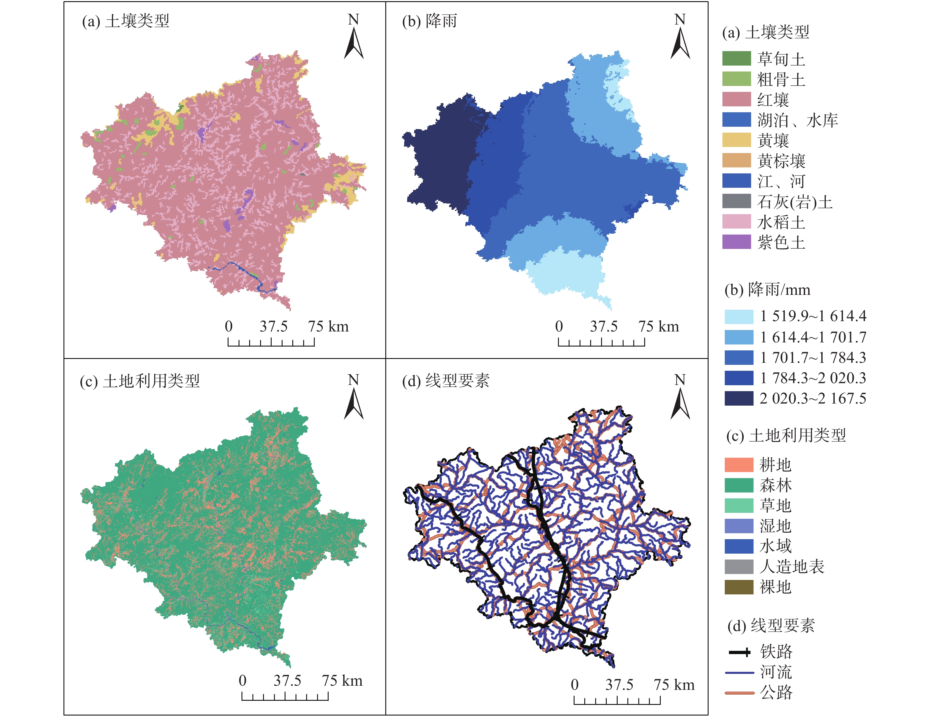
表 1 滑坡致灾因子描述与来源
Table 1. The description and source of landslide inducing factors
因子 描述 来源 高程 ASTER GDEM V2,30 m分辨率 http://www.gscloud.cn 坡度 30 m分辨率 由DEM提取 坡向 30 m分辨率 由DEM提取 曲率 30 m分辨率 由DEM提取 地层岩性 矢量数据 http://www.geodata.cn 土壤类型 重采样至30 m分辨率 http://www.resdc.cn 降雨 1980—2015年平均降雨量,由
降雨站点数据插值http://data.cma.cn 水系 矢量数据 http://www.geodata.cn 土地利用类型 30 m分辨率 http://www.webmap.cn 公路 矢量数据 http://www.webmap.cn 铁路 矢量数据 http://www.webmap.cn  下载: 导出CSV
表 2 因子间相关系数
Table 2. Correlation coefficient of conditional factors
因子 高程 坡度 坡向 曲率 降雨 土地利用 土壤 水系 公路 铁路 高程 1 坡度 0.040 1 坡向 −0.024 −0.047 1 曲率 −0.061* −0.042 −0.001 1 降雨 0.046** −0.009 −0.048* −0.017 1 土地利用 −0.010 −0.010 0.005 0.034 −0.034 1 土壤 0.242** 0.047 −0.004 −0.009 0.180** 0.001 1 水系 −0.296** 0.058* −0.002 0.026 −0.084** −0.031 −0.163** 1 公路 −0.234** −0.099** 0.019 0.044 −0.144** −0.032 −0.114** 0.401** 1 铁路 −0.240** −0.033 0.029 0.025 −0.227** −0.028 −0.273** 0.291** 0.362** 1 注:*表示在 0.05 级别(双尾),相关性显著;**表示在 0.01 级别(双尾),相关性显著。
下载: 导出CSV
表 3 混淆矩阵
Table 3. Confusion matrix
是否滑坡(实际) 是否滑坡(预测) 百分比/% 准确率/% 是 否 是 1466 187 88.64 84.91 否 311 1342 81.18
下载: 导出CSV
-
[1] FAN X M, SCARINGI G, KORUP O, et al. Earthquake-induced chains of geologic hazards: patterns, mechanisms, and impacts[J]. Reviews of Geophysics,2019,57(2):421 − 503. doi: 10.1029/2018RG000626
[2] 邓钟, 黄声享, 朱高龙. 基于近5年灾情数据的福建滑坡灾害时空特征分析[J]. 地质灾害与环境保护,2019,30(4):17 − 23. [DENG Zhong, HUANG Shengxiang, ZHU Gaolong. Temporal and spatial distribution characteristics analysis for Fujian landslide disasters based on disaster data in recent five years[J]. Journal of Geological Hazards and Environment Preservation,2019,30(4):17 − 23. (in Chinese with English abstract) doi: 10.3969/j.issn.1006-4362.2019.04.003
[3] 王涛, 吴树仁, 石菊松, 等. 地震滑坡危险性概念和基于力学模型的评估方法探讨[J]. 工程地质学报,2015,23(1):93 − 104. [WANG Tao, WU Shuren, SHI Jusong, et al. Concepts and mechanical assessment method for seismic landslide hazard: a review[J]. Journal of Engineering Geology,2015,23(1):93 − 104. (in Chinese with English abstract)
[4] TANG C, ZHU J, QI X. Landslide hazard assessment of the 2008 Wenchuan earthquake: A case study in Beichuan area[J]. Canadian Geotechnical Journal,2011,48(1):128 − 145. doi: 10.1139/T10-059
[5] 刘丽娜, 许冲, 徐锡伟, 等. GIS支持下基于AHP方法的2013年芦山地震区滑坡危险性评价[J]. 灾害学,2014,29(4):183 − 191. [LIU Lina, XU Chong, XU Xiwei, et al. GIS-based landslide hazard evaluation using AHP method in the 2013 Lushan earthquake region[J]. Journal of Catastrophology,2014,29(4):183 − 191. (in Chinese with English abstract) doi: 10.3969/j.issn.1000-811X.2014.04.034
[6] VIOLANTE R A, BOZZANO G, ROVERE E I. The marine environment: hazards, resources and the application of geoethics principles[J]. Annals of Geophysics,2018,60:1 − 10. doi: 10.4401/ag-7467
[7] OLEN S, BOOKHAGEN B. Mapping damage-affected areas after natural hazard events using sentinel-1 coherence time series[J]. Remote Sensing,2018,10(8):1272. doi: 10.3390/rs10081272
[8] JAFARIAN Y, LASHGARI A, HADDAD A. Predictive model and probabilistic assessment of sliding displacement for regional scale seismic landslide hazard estimation in IranPredictive model and probabilistic assessment of sliding displacement[J]. Bulletin of the Seismological Society of America,2019,109:1581 − 1593.
[9] 王萌, 乔建平. 贡献权重模型在区域滑坡危险性评价中的应用[J]. 中国地质灾害与防治学报,2010,21(1):1 − 6. [WANG Meng, QIAO Jianping. Application of contributing weights model in regional landslides hazard assessment[J]. The Chinese Journal of Geological Hazard and Control,2010,21(1):1 − 6. (in Chinese with English abstract) doi: 10.3969/j.issn.1003-8035.2010.01.001
[10] DEHNAVI A, AGHDAM I N, PRADHAN B, et al. A new hybrid model using step-wise weight assessment ratio analysis (SWARA) technique and adaptive neuro-fuzzy inference system (ANFIS) for regional landslide hazard assessment in Iran[J]. CATENA,2015,135:122 − 148. doi: 10.1016/j.catena.2015.07.020
[11] BOURENANE H, GUETTOUCHE M S, BOUHADAD Y, et al. Landslide hazard mapping in the Constantine City, Northeast Algeria using frequency ratio, weighting factor, logistic regression, weights of evidence, and analytical hierarchy process methods[J]. Arabian Journal of Geosciences,2016,9(2):1 − 24.
[12] CHEN W, POURGHASEMI H R, KORNEJADY A, et al. Landslide spatial modeling: introducing new ensembles of ANN, MaxEnt, and SVM machine learning techniques[J]. Geoderma,2017,305:314 − 327. doi: 10.1016/j.geoderma.2017.06.020
[13] LUO X G, LIN F K, ZHU S, et al. Mine landslide susceptibility assessment using IVM, ANN and SVM models considering the contribution of affecting factors[J]. PLoS One,2019,14(4):e0215134. doi: 10.1371/journal.pone.0215134
[14] TIAN Y Y, XU C, HONG H Y, et al. Mapping earthquake-triggered landslide susceptibility by use of artificial neural network (ANN) models: an example of the 2013 Minxian (China) Mw 5.9 event[J]. Geomatics, Natural Hazards and Risk,2019,10(1):1 − 25. doi: 10.1080/19475705.2018.1487471
[15] 黄国平, 柳侃, 叶龙珍. 南平市红星滑坡泥石流特征及成因[J]. 地质灾害与环境保护,2014,25(4):20 − 25. [HUANG Guoping, LIU Kan, YE Longzhen. Characteristics and genesis of the Hongxing landslide and debris-flow in Nanping[J]. Journal of Geological Hazards and Environment Preservation,2014,25(4):20 − 25. (in Chinese with English abstract) doi: 10.3969/j.issn.1006-4362.2014.04.003
[16] 江彬, 黄国平, 柳侃. 南平蔡源滑坡泥石流成灾特点及灾后反思[J]. 地质灾害与环境保护,2015,26(4):36 − 39. [JIANG Bin, HUANG Guoping, LIU Kan. The characteristics and experience of landslide and debris flow disaster in Caiyuan Village, Nanping City[J]. Journal of Geological Hazards and Environment Preservation,2015,26(4):36 − 39. (in Chinese with English abstract)
[17] 沈佳, 董岩松, 简文彬, 等. 台风暴雨型土质滑坡演化过程研究[J]. 工程地质学报,2020,28(6):1290 − 1299. [SHEN Jia, DONG Yansong, JIAN Wenbin, et al. Study on evolution process of landslides triggered by typhoon rainstorm[J]. Journal of Engineering Geology,2020,28(6):1290 − 1299. (in Chinese with English abstract)
[18] HUNGR O, LEROUEIL S, PICARELLI L. The Varnes classification of landslide types, an update[J]. Landslides,2014,11(2):167 − 194.
[19] YOUSSEF A M, POURGHASEMI H R, POURTAGHI Z S, et al. Landslide susceptibility mapping using random forest, boosted regression tree, classification and regression tree, and general linear models and comparison of their performance at Wadi Tayyah Basin, Asir Region, Saudi Arabia[J]. Landslides,2016,13(5):839 − 856. doi: 10.1007/s10346-015-0614-1
[20] ZÊZERE J L, PEREIRA S, MELO R, et al. Mapping landslide susceptibility using data-driven methods[J]. Science of the Total Environment,2017,589:250 − 267. doi: 10.1016/j.scitotenv.2017.02.188
[21] SORBINO G, SICA C, CASCINI L. Susceptibility analysis of shallow landslides source areas using physically based models[J]. Natural Hazards,2010,53(2):313 − 332. doi: 10.1007/s11069-009-9431-y
[22] DEN EECKHAUT M V, MARRE A, POESEN J. Comparison of two landslide susceptibility assessments in the Champagne–Ardenne region (France) [J]. Geomorphology, 2010, 115(1-2): 141-55.
[23] REICHENBACH P, ROSSI M, MALAMUD B D, et al. A review of statistically-based landslide susceptibility models[J]. Earth-Science Reviews,2018,180:60 − 91. doi: 10.1016/j.earscirev.2018.03.001
[24] XIAO T, YIN K L, YAO T L, et al. Spatial prediction of landslide susceptibility using GIS-based statistical and machine learning models in Wanzhou County, Three Gorges Reservoir, China[J]. Acta Geochimica,2019,38(5):654 − 669.
[25] XIE W, LI X S, JIAN W B, et al. A novel hybrid method for landslide susceptibility mapping-based GeoDetector and machine learning cluster: A case of Xiaojin County, China[J]. ISPRS International Journal of Geo-Information,2021,10(2):1 − 19.
[26] CANIANI D, PASCALE S, SDAO F, et al. Neural networks and landslide susceptibility: A case study of the urban area of Potenza[J]. Natural Hazards,2008,45(1):55 − 72. doi: 10.1007/s11069-007-9169-3
[27] CHAUHAN S, SHARMA M, ARORA M K, et al. Landslide Susceptibility Zonation through ratings derived from Artificial Neural Network[J]. International Journal of Applied Earth Observation and Geoinformation,2010,12(5):340 − 350. doi: 10.1016/j.jag.2010.04.006
[28] CHEN W, POURGHASEMI H R, ZHAO Zhou. A GIS-based comparative study of Dempster-Shafer, logistic regression and artificial neural network models for landslide susceptibility mapping[J]. Geocarto International,2017,32(4):367 − 385. doi: 10.1080/10106049.2016.1140824
[29] CHEN Y Y, LIN Y H, KUNG C C, et al. Design and implementation of cloud analytics-assisted smart power meters considering advanced artificial intelligence as edge analytics in demand-side management for smart homes[J]. Sensors (Basel, Switzerland),2019,19(9):2047 − 2073. doi: 10.3390/s19092047
[30] WERE K, BUI D T, DICK Ø B, et al. A comparative assessment of support vector regression, artificial neural networks, and random forests for predicting and mapping soil organic carbon stocks across an Afromontane landscape[J]. Ecological Indicators,2015,52:394 − 403. doi: 10.1016/j.ecolind.2014.12.028
-


图(6)
表(3)
计量
- 文章访问数: 2556
- PDF下载数: 226
- 施引文献: 0