

Comprehensive identification of potential and old landslides based on optical remote sensing and InSAR technologies: A case study in northwestern Yunnan Province
-
摘要:
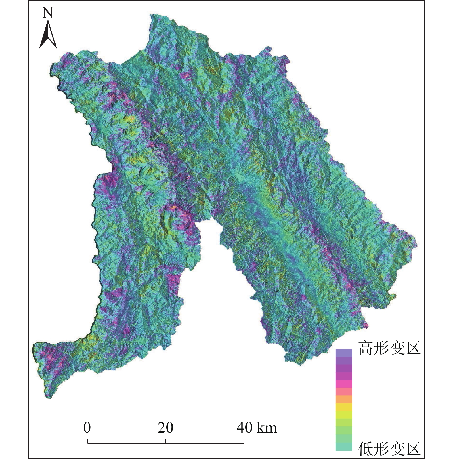
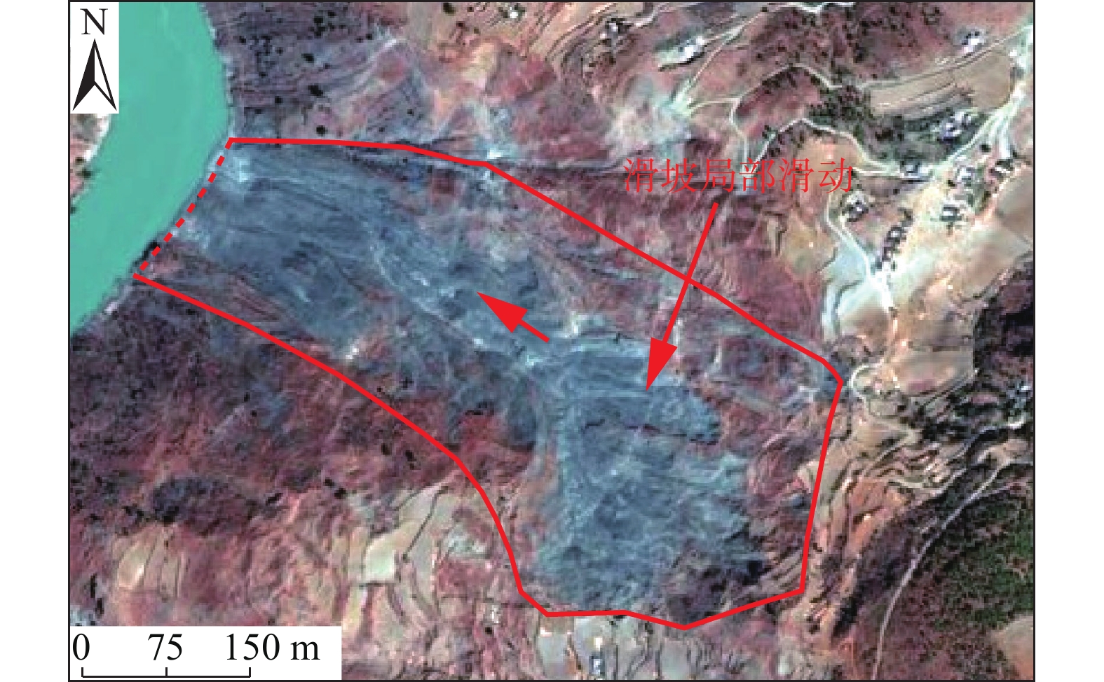
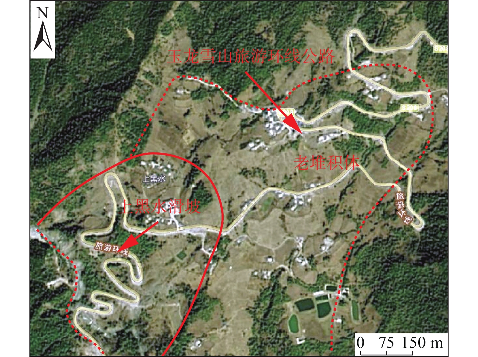
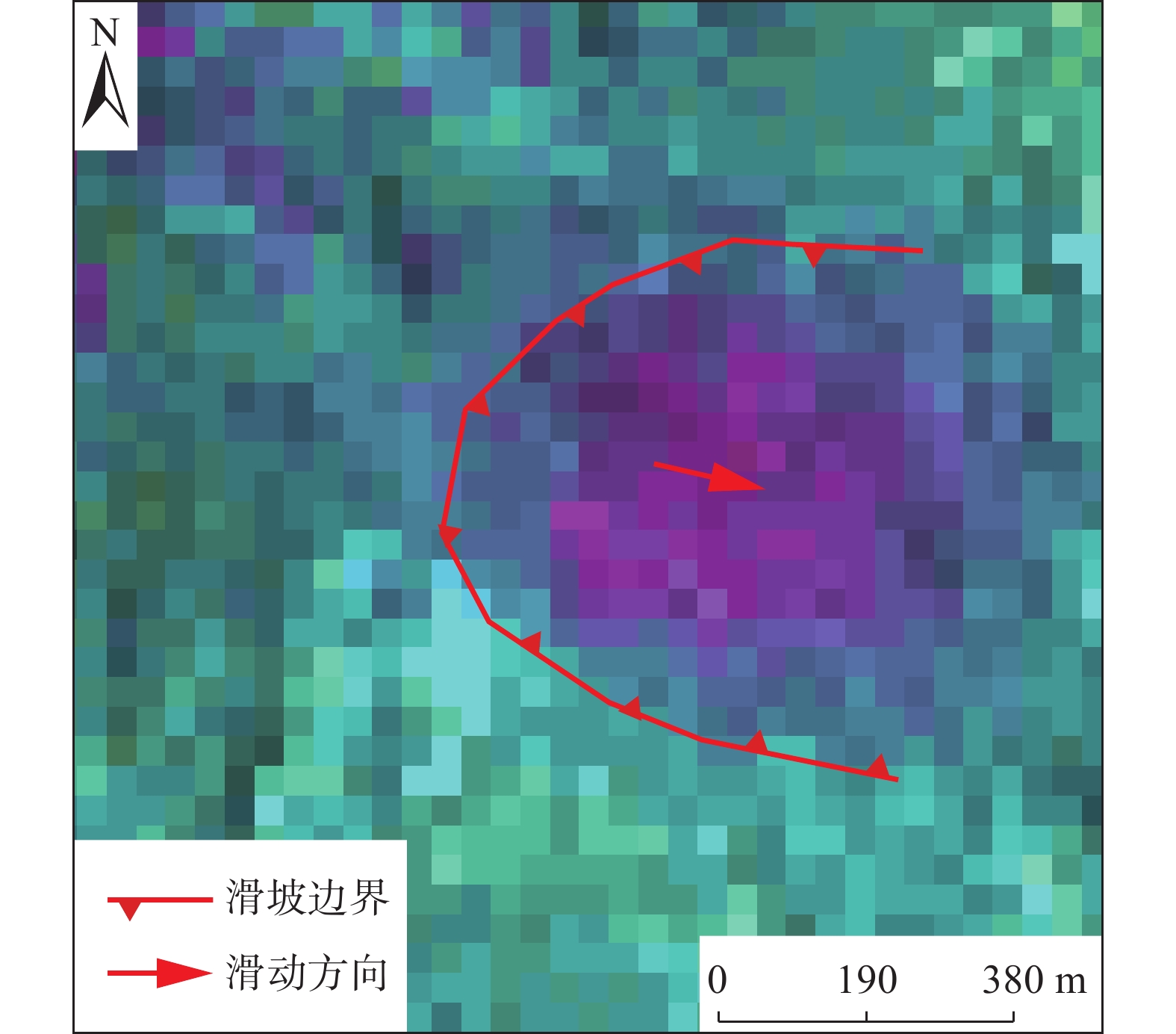
我国滇西北区域地质灾害频发,主要灾害类型为滑坡,对该区域进行滑坡类地质灾害隐患识别是有效的防灾减灾措施,传统的地质灾害隐患识别手段较为单一,且依赖大量的人力,调查效率较低。利用WordView2、Sentinel-1A、ALOS-2几种遥感卫星数据,进行Stacking-InSAR等技术的处理,得到多种光学卫星影像和InSAR处理的地表形变图,建立滇西北区域潜在滑坡与老滑坡的光学解译标志和InSAR识别标志,并进行多次目视解译和人工交互式解译。依据解译、识别成果,总结识别方法并进行野外调查验证。共识别潜在滑坡与老滑坡696处,为今后滇西北区域地质灾害调查与评价提供新的调查思路和技术参考。
Abstract:Potential geological disasters frequently occur in northwestern Yunnan. Landslide is the main type of geohazard. The identification of landslide in this area is an effective disaster prevention and mitigation measure. The traditional methods of identifying potential geological hazards are relatively single and rely on a large number of manpower and the investigation efficiency are not satisfactory. This paper processes the data from WordView2, Sentinel-1A, and ALOS-2 remote sensing satellite by using the Stacking-InSAR and other technologies, and a variety of optical satellite images and InSAR-processed surface deformation maps were obtained. Optical interpretation signs and InSAR identification signs had undergone multiple visual interpretations and manual interactive interpretations, and based on the interpretation and recognition results, the identification methods are summarized and field investigations were also carried out to verify the results. A total of 806 potential landslides and old landslides were identified, providing new survey ideas and technical references for the future investigation and evaluation of geological disasters in northwestern Yunnan.
-

-
表 1 Sentinel-A雷达数据基本参数
Table 1. Basic parameters of the Sentinel-A radar data
星载SAR系统 Sentinel-1A 所属国家/机构 欧空局 轨道高度/km 693 波长/cm C(5.6) 观测时间间隔/d 12 运行时间 2014—2021 测量变形精度 毫米级 极化方式 HH+HV, VV+VH 地面分辨率/m 集束模式5×5、条带模式5×20
扫描模式20×20、加宽扫描20×40影像幅宽/km 集束模式20、条带模式80
扫描模式250、加宽扫描400 下载: 导出CSV
表 2 ALOS-2雷达数据基本参数
Table 2. Basic parameters of ALOS-2 radar data
SAR系统参数 参数内容 发射时间 2014年5月 频率/GHz 1.2 重访周期/d 14 拟用拍摄模式 Ultra-Fine 入射角/(°) 29.1~38.2 分辨率/m 3×3 幅宽/km 50 极化模式 HH+HV/VV+VH/HH/VV/HV/VH
下载: 导出CSV
-
[1] 王之栋, 文学虎, 唐伟, 等. 联合多种InSAR技术的龙门山—大渡河区域地灾隐患早期探测[J]. 武汉大学学报·信息科学版,2020,45(3):451 − 459. [WANG Zhidong, WEN Xuehu, TANG Wei, et al. Early detection of geological hazards in Longmenshan-Dadu River area using various InSAR techniques[J]. Geomatics and Information Science of Wuhan University,2020,45(3):451 − 459. (in Chinese with English abstract)
WANG Zhidong, WEN Xuehu, TANG Wei, et al. Early detection of geological hazards in Longmenshan-Dadu River area using various InSAR techniques[J]. Geomatics and Information Science of Wuhan University, 2020, 45(3): 451-459. (in Chinese with English abstract)
[2] 苏轶君. 基于高分遥感影像的泥石流潜在形成区识别方法探讨[J]. 中国地质灾害与防治学报,2020,31(5):22 − 31. [SU Yijun. Probing into the techniques recognizing potential debris flow formation regions[J]. The Chinese Journal of Geological Hazard and Control,2020,31(5):22 − 31. (in Chinese with English abstract)
SU Yijun. Probing into the techniques recognizing potential debris flow formation regions[J]. The Chinese Journal of Geological Hazard and Control, 2020, 31(5): 22-31. (in Chinese with English abstract)
[3] 许强, 李为乐, 董秀军, 等. 四川茂县叠溪镇新磨村滑坡特征与成因机制初步研究[J]. 岩石力学与工程学报,2017,36(11):2612 − 2628. [XU Qiang, LI Weile, DONG Xiujun, et al. The Xinmocun landslide on June 24, 2017 in Maoxian, Sichuan: Characteristics and failure mechanism[J]. Chinese Journal of Rock Mechanics and Engineering,2017,36(11):2612 − 2628. (in Chinese with English abstract)
XU Qiang, LI Weile, DONG Xiujun, et al. The Xinmocun landslide on June 24, 2017 in Maoxian, Sichuan: characteristics and failure mechanism[J]. Chinese Journal of Rock Mechanics and Engineering, 2017, 36(11): 2612-2628. (in Chinese with English abstract)
[4] 郭延辉, 杨溢, 杨志全, 等. 国产GB-InSAR在特大型水库滑坡变形监测中的应用[J]. 中国地质灾害与防治学报,2021,32(2):66 − 72. [GUO Yanhui, YANG Yi, YANG Zhiquan, et al. Application of GB-InSAR in deformation monitoring of huge landslide in reservoir area[J]. The Chinese Journal of Geological Hazard and Control,2021,32(2):66 − 72. (in Chinese with English abstract)
GUO Yanhui, YANG Yi, YANG Zhiquan, et al. Application of GB-InSAR in deformation monitoring of huge landslide in reservoir area[J]. The Chinese Journal of Geological Hazard and Control, 2021, 32(2): 66-72. (in Chinese with English abstract)
[5] NICHOL J E, SHAKER A, WONG M S. Application of high-resolution stereo satellite images to detailed landslide hazard assessment[J]. Geomorphology,2006,76(1/2):68 − 75.
[6] 王瑞国. 基于WorldView-2数据的乌东煤矿地质灾害遥感调查及成因分析[J]. 国土资源遥感,2016,28(2):132 − 138. [WANG Ruiguo. Remote sensing investigation and analysis of geological disasters in the Wudong coal mine based on World View-2 data[J]. Remote Sensing for Land & Resources,2016,28(2):132 − 138. (in Chinese with English abstract)
WANG Ruiguo. Remote sensing investigation and analysis of geological disasters in the Wudong coal mine based on World View- 2 data[J]. Remote Sensing for Land & Resources, 2016, 28(2): 132-138. (in Chinese with English abstract)
[7] 邓云凯, 禹卫东, 张衡, 等. 未来星载SAR技术发展趋势[J]. 雷达学报,2020,9(1):1 − 33. [DENG Yunkai, YU Weidong, ZHANG Heng, et al. Forthcoming spaceborne SAR development[J]. Journal of Radars,2020,9(1):1 − 33. (in Chinese with English abstract) doi: 10.12000/JR20008
DENG Yunkai, YU Weidong, ZHANG Heng, et al. Forthcoming spaceborne SAR development[J]. Journal of Radars, 2020, 9(1): 1-33. (in Chinese with English abstract) doi: 10.12000/JR20008
[8] 刘星洪, 姚鑫, 周振凯, 等. 滑坡灾害InSAR应急排查技术方法研究[J]. 地质力学学报,2018,24(2):229 − 237. [LIU Xinghong, YAO Xin, ZHOU Zhenkai, et al. Study of the technique for landslide rapid recognition by insar[J]. Journal of Geomechanics,2018,24(2):229 − 237. (in Chinese with English abstract) doi: 10.12090/j.issn.1006-6616.2018.24.02.024
LIU Xinghong, YAO Xin, ZHOU Zhenkai, et al. Study of the technique for landslide rapid recognition by insar[J]. Journal of Geomechanics, 2018, 24(2): 229-237. (in Chinese with English abstract) doi: 10.12090/j.issn.1006-6616.2018.24.02.024
[9] 戴可人, 铁永波, 许强, 等. 高山峡谷区滑坡灾害隐患InSAR早期识别—以雅砻江中段为例[J]. 雷达学报,2020,9(3):554 − 568. [DAI Keren, TIE Yongbo, XU Qiang, et al. Early identification of potential landslide geohazards in alpine-canyon terrain based on SAR interferometry: A case study of the middle section of yalong river[J]. Journal of Radars,2020,9(3):554 − 568. (in Chinese with English abstract) doi: 10.12000/JR20012
DAI Keren, TIE Yongbo, XU Qiang, et al. Early identification of potential landslide geohazards in alpine-canyon terrain based on SAR interferometry—a case study of the middle section of yalong river[J]. Journal of Radars, 2020, 9(3): 554-568. (in Chinese with English abstract) doi: 10.12000/JR20012
[10] 杨成生, 董继红, 朱赛楠, 等. 金沙江结合带巴塘段滑坡群InSAR探测识别与形变特征[J]. 地球科学与环境学报,2021,43(2):398 − 408. [YANG Chengsheng, DONG Jihong, ZHU Sainan, et al. Detection, identification and deformation characteristics of landslide groups by InSAR in Batang section of Jinsha River convergence zone, China[J]. Journal of Earth Sciences and Environment,2021,43(2):398 − 408. (in Chinese with English abstract)
YANG Chengsheng, DONG Jihong, ZHU Sainan, et al. Detection, identification and deformation characteristics of landslide groups by InSAR in Batang section of Jinsha River convergence zone, China[J]. Journal of Earth Sciences and Environment, 2021, 43(2): 398-408. (in Chinese with English abstract)
[11] 司马文. 2014年世界遥感卫星回顾[J]. 数字通信世界,2015(2):44 − 59. [SIMA Wen. 2014 world remote sensing satellite review[J]. Digital Communication World,2015(2):44 − 59. (in Chinese) doi: 10.3969/j.issn.1672-7274.2015.02.016
SIMA Wen. 2014 World Remote Sensing Satellite Review [J]. Digital Communication World, 2015(2): 44-59. (in Chinese) doi: 10.3969/j.issn.1672-7274.2015.02.016
[12] 梁顺林, 白瑞, 陈晓娜, 等. 2019年中国陆表定量遥感发展综述[J]. 遥感学报,2020,24(6):618 − 671. [LIANG Shunlin, BAI Rui, CHEN Xiaona, et al. Review of China's land surface quantitative remote sensing development in 2019[J]. Journal of Remote Sensing,2020,24(6):618 − 671. (in Chinese with English abstract)
LIANG Shunlin, BAI Rui, CHEN Xiaona, et al. Review of China's land surface quantitative remote sensing development in 2019[J]. Journal of Remote Sensing, 2020, 24(6): 618-671. (in Chinese with English abstract)
[13] 朱建军, 李志伟, 胡俊. InSAR变形监测方法与研究进展[J]. 测绘学报,2017,46(10):1717 − 1733. [ZHU Jianjun, LI Zhiwei, HU Jun. Research progress and methods of InSAR for deformation monitoring[J]. Acta Geodaetica et Cartographica Sinica,2017,46(10):1717 − 1733. (in Chinese with English abstract) doi: 10.11947/j.AGCS.2017.20170350
ZHU Jianjun, LI Zhiwei, HU Jun. Research progress and methods of InSAR for deformation monitoring[J]. Acta Geodaetica et Cartographica Sinica, 2017, 46(10): 1717-1733. (in Chinese with English abstract) doi: 10.11947/j.AGCS.2017.20170350
[14] 董文, 潘建平, 阳振宇, 等. 高分二号卫星数据在地质灾害调查中的应用—以重庆万州区为例[J]. 中国地质灾害与防治学报,2019,30(1):106 − 111. [DONG Wen, PAN Jianping, YANG Zhenyu, et al. Application of GF-2 satellite data in geological hazard survey: A case study in Wanzhou District of Chongqing City[J]. The Chinese Journal of Geological Hazard and Control,2019,30(1):106 − 111. (in Chinese with English abstract)
DONG Wen, PAN Jianping, YANG Zhenyu, et al. Application of GF-2 satellite data in geological hazard survey: a case study in Wanzhou District of Chongqing City[J]. The Chinese Journal of Geological Hazard and Control, 2019, 30(1): 106-111. (in Chinese with English abstract)
[15] 侯燕军, 周小龙, 石鹏卿, 等. “空-天-地”一体化技术在滑坡隐患早期识别中的应用:以兰州普兰太公司滑坡为例[J]. 中国地质灾害与防治学报,2020,31(6):12 − 20. [HOU Yanjun, ZHOU Xiaolong, SHI Pengqing, et al. Application of “Air-Space-Ground” integrated technology in early identification of landslide hidden danger: taking Lanzhou Pulantai Company Landslide as an example[J]. The Chinese Journal of Geological Hazard and Control,2020,31(6):12 − 20. (in Chinese with English abstract)
HOU Yanjun, ZHOU Xiaolong, SHI Pengqing, et al. Application of “Air-Space-Ground” integrated technology in early identification of landslide hidden danger: taking Lanzhou Pulantai Company Landslide as an example[J]. The Chinese Journal of Geological Hazard and Control, 2020, 31(6): 12-20. (in Chinese with English abstract)
-


图(14)
表(2)
计量
- 文章访问数: 4508
- PDF下载数: 281
- 施引文献: 0