

Application of combined space, arial and ground based multiple technologies in deformation monitoring of mining areas
-
摘要:
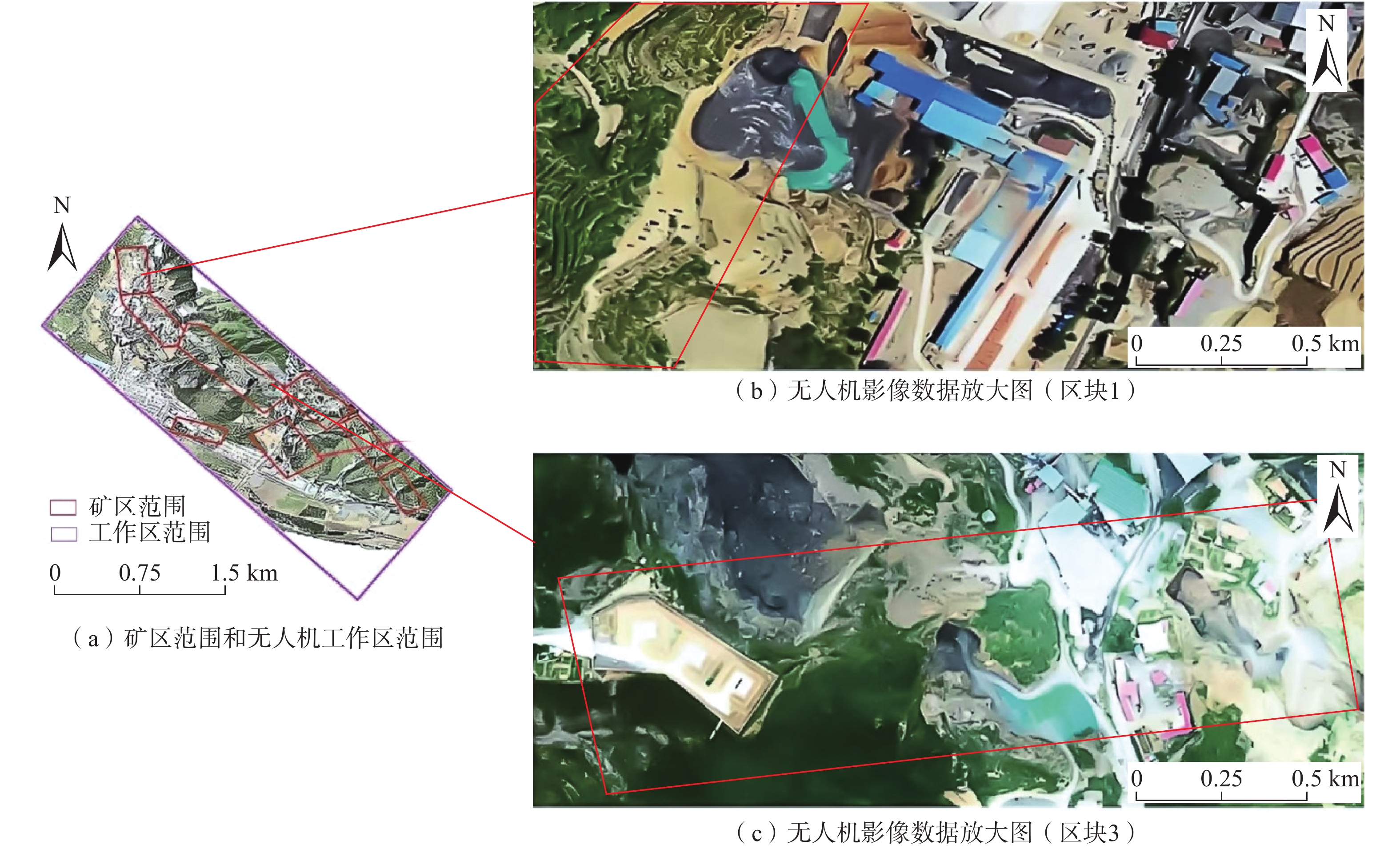
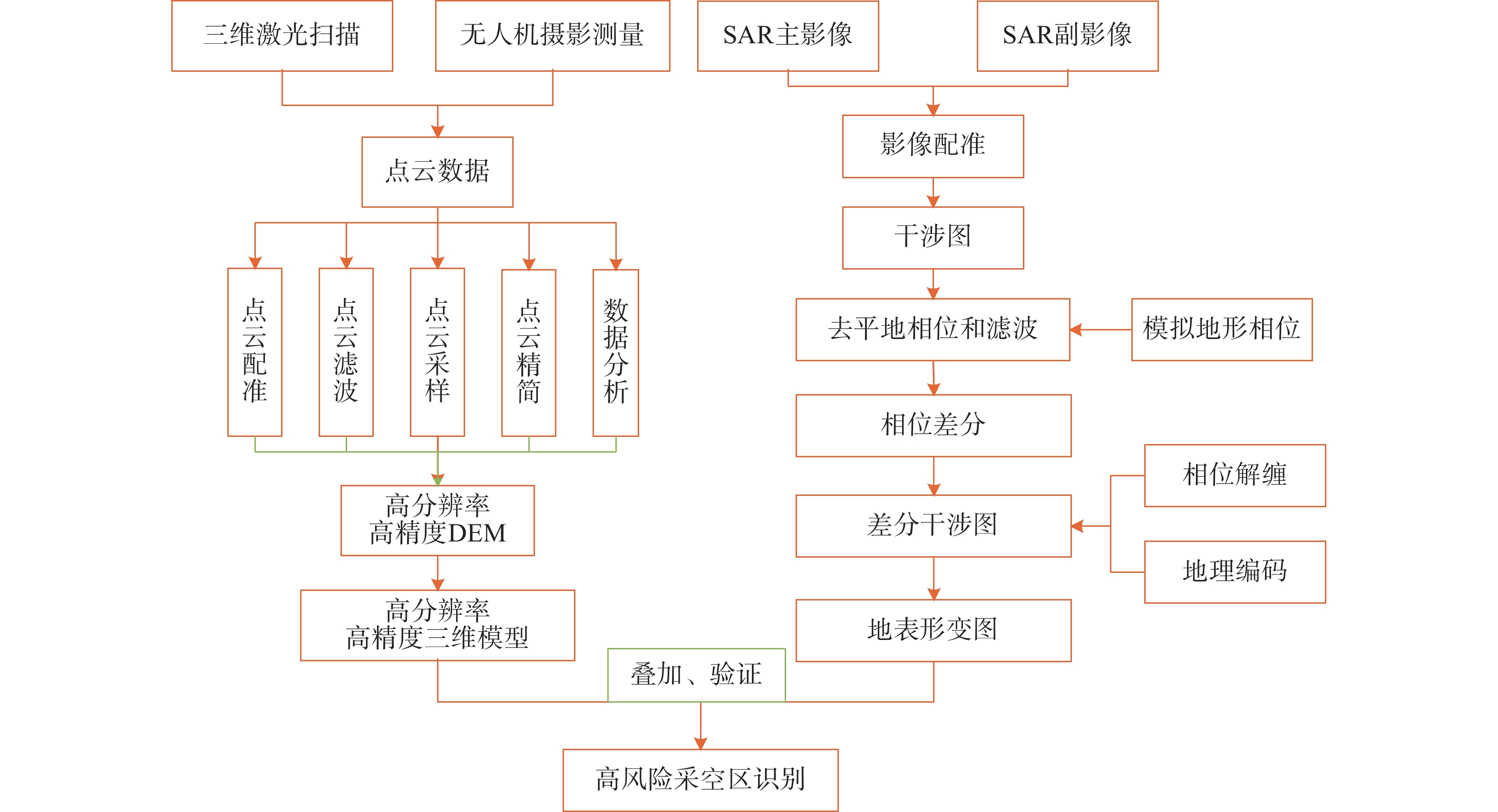
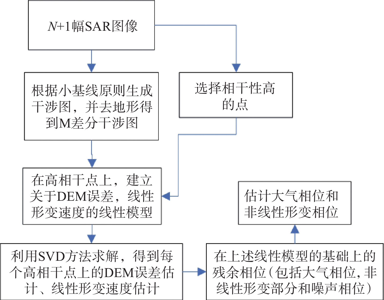
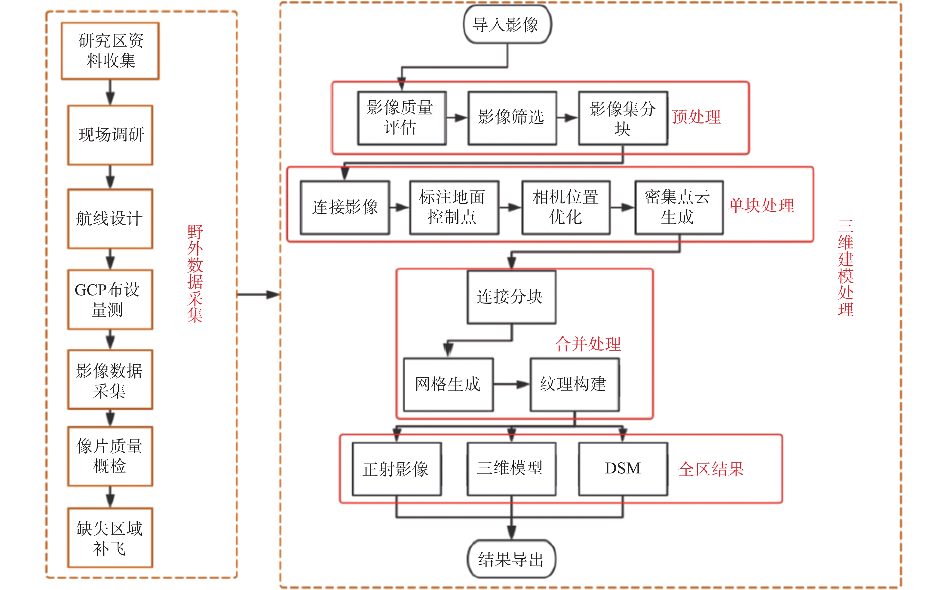
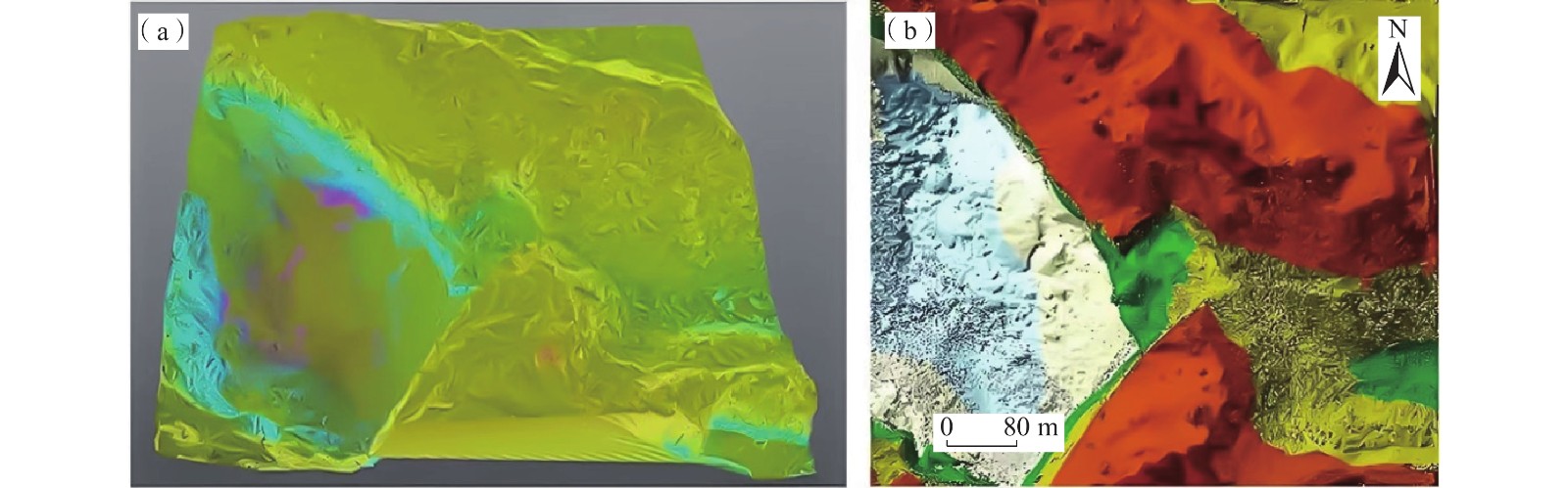
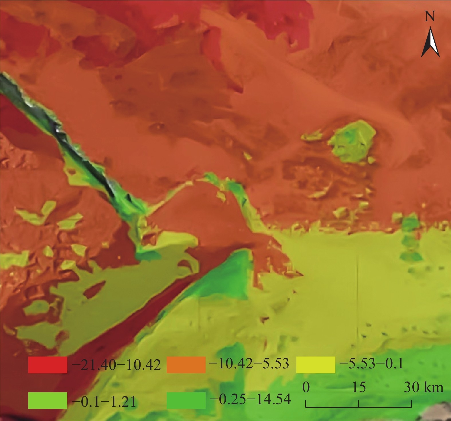
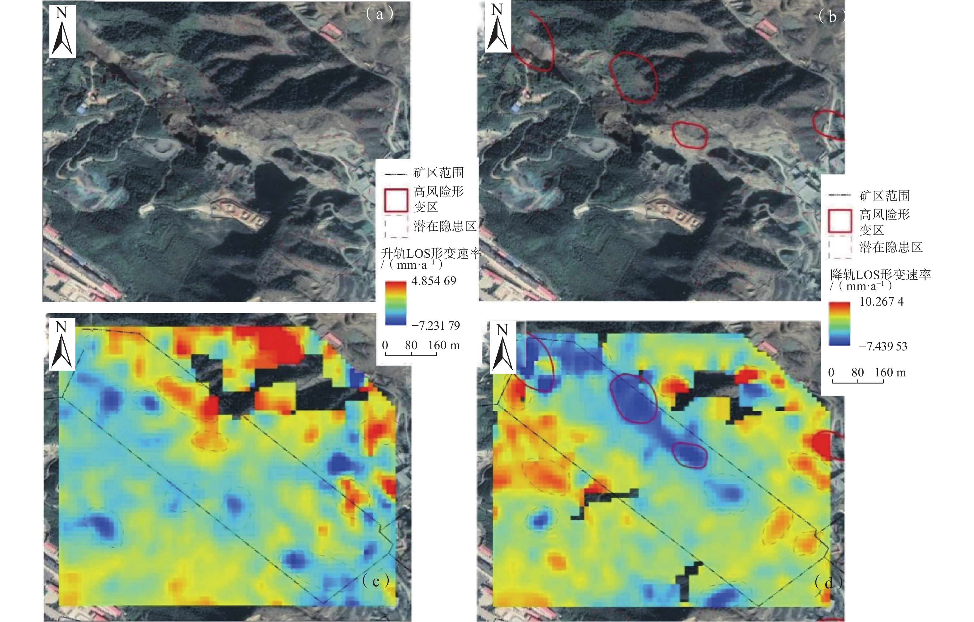
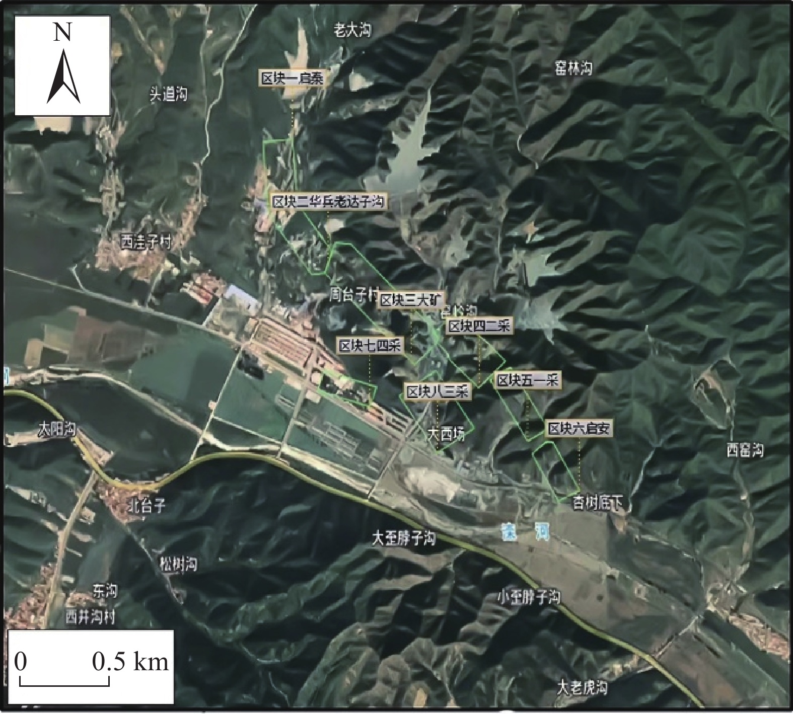
河北滦平县张百湾镇周台子村由于多年矿山开采遗留下大量的采空区,部分采空区未做任何处理存在塌陷隐患,严重制约当地的经济发展和社会稳定。对该地区采空区形变调查和实地监测十分有必要。文中综合应用合成孔径雷达干涉测量技术、无人机摄影测量技术、三维激光扫描技术对采空区的空间分布进行划分确定和形变监测。首先应用小基线集技术对采空区进行地表形变解算。然后应用无人机数据构建研究区的三维模型,并通过多期无人机航飞数据,计算2次航飞间地表变化,佐证InSAR技术的结果。最后应用三维激光扫描技术,对部分重点区域进行三维激光扫描,建立采空区精细化模型。研究结果表明,三种技术的联合监测结果表现出高度的一致性,其中InSAR技术探测出研究区最大形变速率−25 mm/a,结合2期无人机正射模型DEM与三维激光扫描数据差分结果确定出采空区17处的高风险区域,部分区域对居民区和道路有影响。基于“空天地”一体化技术具有较高的可靠性,可应用于矿区采空区形变调查和地面沉降监测。
-
关键词:
- 采空区 /
- InSAR技术 /
- 无人机摄影测量 /
- SBAS-InSAR /
- 三维激光扫描
Abstract:There are a large number of iron mine gobs due to many years of mining in Zhoutaizi Village, Zhangbaiwan Town, Luanping County. And some gobs have potential safety hazards of collapse, which seriously restrict the local economic development and social stability. So it is necessary to strengthen deformation investigation and field monitoring of existing gobs in this area. In this paper, the spatial distribution of gobs in the study area is determined and deformation of gobs is monitored by using Interferometric Synthetic Aperture Radar (InSAR), UAV photogrammetry and 3D laser scanning technology. Firstly, Small Baseline Subset InSAR (SBAS-InSAR) technology is used to retrieve the surface deformation of gobs. Then, a three-dimensional model of the study area is constructed by using UAV data, and the ground surface changes between two flights are calculated by using multi-period UAV flight data to support the results of InSAR technology. Finally, 3D laser scanning technology is applied to some areas, and the fine model of gobs is established. The results show that the joint monitoring results of the three technologies show a high consistency, the maximum deformation rate (−25 mm/a) of the study area are detected by InSAR method. Combined with the difference results of the DEM and 3D laser scanning data of the two periods of UAV, 17 high-risk areas of gobs are identified. The high-risk areas are distributed in various mining areas, and some areas have an impact on residential areas and roads. The based on Space, Sky and Ground multi-technology indicating that this method has high reliability and can be well applied to deformation investigation of goaf in mining area and the surface deformation monitoring during inadequate mining.
-
Key words:
- gobs /
- InSAR technology /
- UAV photogrammetry /
- SBAS-InSAR /
- 3D laser scanning
-

-
表 1 研究区Sentinel-1数据
Table 1. Sentinel-1 data in the research area
Sentinel-1A升轨影像数据集 编号 成像日期 垂直基线/m 时间基线/d 多普勒频差/Hz 高程模糊度/m 0 2018-11-06 0.00 0 0.00 0.00 1 2018-12-12 57.96 36 −4.61 262.75 2 2019-01-05 −8.46 60 7.27 1 799.97 3 2019-02-10 95.92 96 3.33 158.75 4 2019-03-06 113.21 120 5.57 134.52 5 2019-04-11 125.46 156 −3.34 121.38 6 2019-11-01 128.02 360 −5.10 118.96 7 2019-12-07 74.24 396 −3.10 205.13 8 2020-01-12 61.75 432 0.86 246.60 9 2020-02-05 62.86 456 0.54 242.27 10 2020-03-12 141.33 492 2.36 107.75 11 2020-04-05 97.92 516 3.22 155.52 Sentinel-1A降轨影像数据集 编号 成像日期 垂直基线/m 时间基线/d 多普勒频差/Hz 高程模糊度/m 0 2018-11-05 0.00 0 0.00 0.00 1 2018-12-11 32.79 36 1.49 518.88 2 2019-01-04 −30.31 60 3.69 561.38 3 2019-02-09 17.13 96 1.14 993.06 4 2019-03-05 −39.30 120 −7.84 432.96 5 2019-04-10 61.11 156 −14.1 278.41 6 2019-11-12 −31.83 372 −2.95 534.49 7 2019-12-06 47.26 396 4.70 360.03 8 2020-01-11 −58.43 432 −3.82 291.19 9 2020-02-04 −9.43 456 1.16 1 805.11 10 2020-03-11 −5.50 492 −7.30 3 095.02  下载: 导出CSV
-
[1] 孙健. 基于二等水准测量的矿区沉降监测研究分析[J]. 北京测绘,2019,33(8):979 − 981. [SUN Jian. Research and analysis of mining area settlement monitoring based on second-class measurement[J]. Beijing Surveying and Mapping,2019,33(8):979 − 981. (in Chinese with English abstract)
SUN Jian. Research and analysis of mining area settlement monitoring based on second-class measurement[J]. Beijing Surveying and Mapping, 2019, 33(8): 979-981. (in Chinese with English abstract)
[2] 范发龙. 变形监测技术在矿井采空区沉降观测中的应用研究[J]. 山东煤炭科技,2019(6):175 − 176. [FAN Falong. Application of deformation monitoring technology in mine goaf settlement observation[J]. Shandong Coal Science and Technology,2019(6):175 − 176. (in Chinese with English abstract)
FAN Falong. Application of deformation monitoring technology in mine goaf settlement observation[J]. Shandong Coal Science and Technology, 2019(6): 175-176. (in Chinese with English abstract)
[3] 唐凯. 基于单机站CORS的矿区开采沉陷监测研究[J]. 测绘与空间地理信息,2017,40(11):162 − 164. [TANG Kai. Research on mining subsidence monitoring based on CORS single station[J]. Geomatics & Spatial Information Technology,2017,40(11):162 − 164. (in Chinese)
TANG Kai. Research on mining subsidence monitoring based on CORS single station[J]. Geomatics & Spatial Information Technology, 2017, 40(11): 162-164. (in Chinese)
[4] 李丽,杨金中,陈栋,等. 长江经济带江苏段废弃露天矿山分布与生态修复遥感调查研究[J]. 水文地质工程地质,2022,49(1):183 − 190. [LI Li,YANG Jinzhong,CHEN Dong,et al. Remote sensing investigation on the distribution and ecological restoration of abandoned open-pit mines in Jiangsu section of Yangtze River Economic Belt[J]. Hydrogeology & Engineering Geology,2022,49(1):183 − 190. (in Chinese)
LI Li, YANG Jinzhong, CHEN Dong, et al. Remote sensing investigation on the distribution and ecological restoration of abandoned open-pit mines in Jiangsu section of Yangtze River Economic Belt[J]. Hydrogeology & Engineering Geology, 2022, 49(1): 183-190. (in Chinese)
[5] 刘童谣,胡海峰,廉旭刚,等. 时间相邻-四轨法的D-InSAR矿区沉陷监测研究[J]. 测绘科学,2020,45(2):121 − 127. [LIU Tongyao,HU Haifeng,LIAN Xugang,et al. Research on mining area subsidence monitoring by time-adjacent four-pass D-InSAR technology[J]. Science of Surveying and Mapping,2020,45(2):121 − 127. (in Chinese with English abstract)
LIU Tongyao, HU Haifeng, LIAN Xugang, et al. Research on mining area subsidence monitoring by time-adjacent four-pass D-InSAR technology[J]. Science of Surveying and Mapping, 2020, 45(2): 121-127. (in Chinese with English abstract)
[6] 朱建军,杨泽发,李志伟. InSAR矿区地表三维形变监测与预计研究进展[J]. 测绘学报,2019,48(2):135 − 144. [ZHU Jianjun,YANG Zefa,LI Zhiwei. Recent progress in retrieving and predicting mining-induced 3D displace-ments using InSAR[J]. Acta Geodaetica et Cartographica Sinica,2019,48(2):135 − 144. (in Chinese with English abstract)
ZHU Jianjun, YANG Zefa, LI Zhiwei. Recent progress in retrieving and predicting mining-induced 3D displace-ments using InSAR[J]. Acta Geodaetica et Cartographica Sinica, 2019, 48(2): 135-144. (in Chinese with English abstract)
[7] 胡晓,李新举. 基于无人机的高潜水位煤矿区沉陷耕地提取方法比较[J]. 煤炭学报,2019,44(11):3547 − 3555. [HU Xiao,LI Xinju. Comparison the extraction methods of subsided cultivated land in high- groundwater-level coal mines based on unmanned aerial vehicle[J]. Journal of China Coal Society,2019,44(11):3547 − 3555. (in Chinese with English abstract)
HU Xiao, LI Xinju. Comparison the extraction methods of subsided cultivated land in high- groundwater-level coal mines based on unmanned aerial vehicle[J]. Journal of China Coal Society, 2019, 44(11): 3547-3555. (in Chinese with English abstract)
[8] 朱海斌,王妍,李亚梅. 基于无人机的露天矿区测绘研究[J]. 煤炭工程,2018,50(10):162 − 166. [ZHU Haibin,WANG Yan,LI Yamei. Surveying and mapping of open-pit mining area using unmanned aerial vehicle[J]. Coal Engineering,2018,50(10):162 − 166. (in Chinese with English abstract)
ZHU Haibin, WANG Yan, LI Yamei. Surveying and mapping of open-pit mining area using unmanned aerial vehicle[J]. Coal Engineering, 2018, 50(10): 162-166. (in Chinese with English abstract)
[9] 陈朋. 应用三维激光扫描同步监测矿区地表与建筑物形变的研究[D]. 徐州: 中国矿业大学
CHEN Peng. Study on synchronous monitoring of ground surface and building deformation in mining area by three-dimensional laser scanning[D]. Xuzhou: China University of Mining and Technology. (in Chinese with English abstract)
[10] 何荣,陆广. 基于三维激光扫描的矿区地表倾斜值提取方法研究[J]. 煤炭科学技术,2020,48(11):199 − 205. [HE Rong,LU Guang. Study on extraction method of surface deformation tilt based on 3D laser scanning[J]. Coal Science and Technology,2020,48(11):199 − 205. (in Chinese with English abstract)
HE Rong, LU Guang. Study on extraction method of surface deformation tilt based on 3D laser scanning[J]. Coal Science and Technology, 2020, 48(11): 199-205. (in Chinese with English abstract)
[11] 多晓松. 基于INSAR与TRT的某小区地下采空区分析[J]. 有色金属(矿山部分),2021,73(5):58 − 62. [DUO Xiaosong. Analysis of underground goaf in a small area based on InSAR and TRT[J]. Nonferrous Metals (Mining Section),2021,73(5):58 − 62. (in Chinese with English abstract)
DUO Xiaosong. Analysis of underground goaf in a small area based on InSAR and TRT[J]. Nonferrous Metals (Mining Section), 2021, 73(5): 58-62. (in Chinese with English abstract)
[12] 韩旭东,付杰,李严严,等. 舟曲江顶崖滑坡的早期判识及风险评估研究[J]. 水文地质工程地质,2021,48(6):180 − 186. [HAN Xudong,FU Jie,LI Yanyan,et al. A study of the early identification and risk assessment of the Jiangdingya landslide in Zhouqu County[J]. Hydrogeology & Engineering Geology,2021,48(6):180 − 186. (in Chinese with English abstract)
HAN Xudong, FU Jie, LI Yanyan, et al. A study of the early identification and risk assessment of the Jiangdingya landslide in Zhouqu County[J]. Hydrogeology & Engineering Geology, 2021, 48(6): 180-186. (in Chinese with English abstract)
[13] YAGÜE-MARTÍNEZ N,PRATS-IRAOLA P,RODRÍGUEZ GONZÁLEZ F,et al. Interferometric processing of sentinel-1 TOPS data[J]. IEEE Transactions on Geoscience and Remote Sensing,2016,54(4):2220 − 2234. doi: 10.1109/TGRS.2015.2497902
[14] 张晓波, 刘凯, 蒋鹏, 等. 基于约束条件的深圳市南山区地下空间开发地质适宜性评价[J/OL]. 水文地质工程地质: 1 − 12[2023-05-23]
ZHANG Xiaobo, LIU Kai, JIANG Peng, et al. Geological suitability evaluation of underground space development in Nanshan District of Shenzhen City based on constraint conditions[J/OL]. Hydrogeology and engineering geology: 1 − 12[2023-05-23] (in Chinese with English abstract)
[15] 叶俊能,尹铁锋,杜培贞. 基于压差传感技术的坑底隆起监测方法及应用[J]. 水文地质工程地质,2017,44(6):96 − 101. [YE Junneng,YIN Tiefeng,DU Peizhen. Monitoring method of bottom heave based on pressure difference sensing technique and its application[J]. Hydrogeology & Engineering Geology,2017,44(6):96 − 101. (in Chinese with English abstract)
YE Junneng, YIN Tiefeng, DU Peizhen. Monitoring method of bottom heave based on pressure difference sensing technique and its application[J]. Hydrogeology & Engineering Geology, 2017, 44(6): 96-101. (in Chinese with English abstract)
[16] 张凯翔. 基于“3S”技术的地质灾害监测预警系统在我国应用现状[J]. 中国地质灾害与防治学报,2020,31(6):1 − 11. [ZHANG Kaixiang. Review on geological disaster monitoring and early warning system based on “3S” technology in China[J]. The Chinese Journal of Geological Hazard and Control,2020,31(6):1 − 11. (in Chinese with English abstract)
ZHANG Kaixiang. Review on geological disaster monitoring and early warning system based on “3S” technology in China[J]. The Chinese Journal of Geological Hazard and Control, 2020, 31(6): 1-11. (in Chinese with English abstract)
[17] 宋京雷,郝社锋,岳翎,等. 采矿引起的将军崖岩画区倾倒变形机理及治理措施分析[J]. 中国地质灾害与防治学报,2017,28(4):40 − 46. [SONG Jinglei,HAO Shefeng,YUE Ling,et al. Deformation mechanism and treatment measures of the mining-induced toppling deformation in rock painting area in Jiangjun cliff[J]. The Chinese Journal of Geological Hazard and Control,2017,28(4):40 − 46. (in Chinese with English abstract)
SONG Jinglei, HAO Shefeng, YUE Ling, et al. Deformation mechanism and treatment measures of the mining-induced toppling deformation in rock painting area in Jiangjun cliff[J]. The Chinese Journal of Geological Hazard and Control, 2017, 28(4): 40-46. (in Chinese with English abstract)
[18] 芦彦霖,张森,汲姣. 低空无人机倾斜摄影测量测图精度实证[J]. 吉林大学学报(地球科学版),2021,51(6):1921 − 1931. [LU Yanlin,ZHANG Sen,JI Jiao. Real evidence of mapping accuracy of low-altitude UAV tilt photogrammetry[J]. Journal of Jilin University (Earth Science Edition),2021,51(6):1921 − 1931. (in Chinese with English abstract)
LU Yanlin, ZHANG Sen, JI Jiao. Real evidence of mapping accuracy of low-altitude UAV tilt photogrammetry[J]. Journal of Jilin University (Earth Science Edition), 2021, 51(6): 1921-1931. (in Chinese with English abstract)
[19] 吴志春,郭福生,林子瑜,等. 三维地质建模中的多源数据融合技术与方法[J]. 吉林大学学报(地球科学版),2016,46(6):1895 − 1913. [WU Zhichun,GUO Fusheng,LIN Ziyu,et al. Technology and method of multi-data merging in 3D geological modeling[J]. Journal of Jilin University (Earth Science Edition),2016,46(6):1895 − 1913. (in Chinese with English abstract)
WU Zhichun, GUO Fusheng, LIN Ziyu, et al. Technology and method of multi-data merging in 3D geological modeling[J]. Journal of Jilin University (Earth Science Edition), 2016, 46(6): 1895-1913. (in Chinese with English abstract)
-


图(16)
表(1)
计量
- 文章访问数: 2953
- PDF下载数: 159
- 施引文献: 0