

Risk assessment of geological disasters in Nanjing, Jiangsu Province
-
摘要:
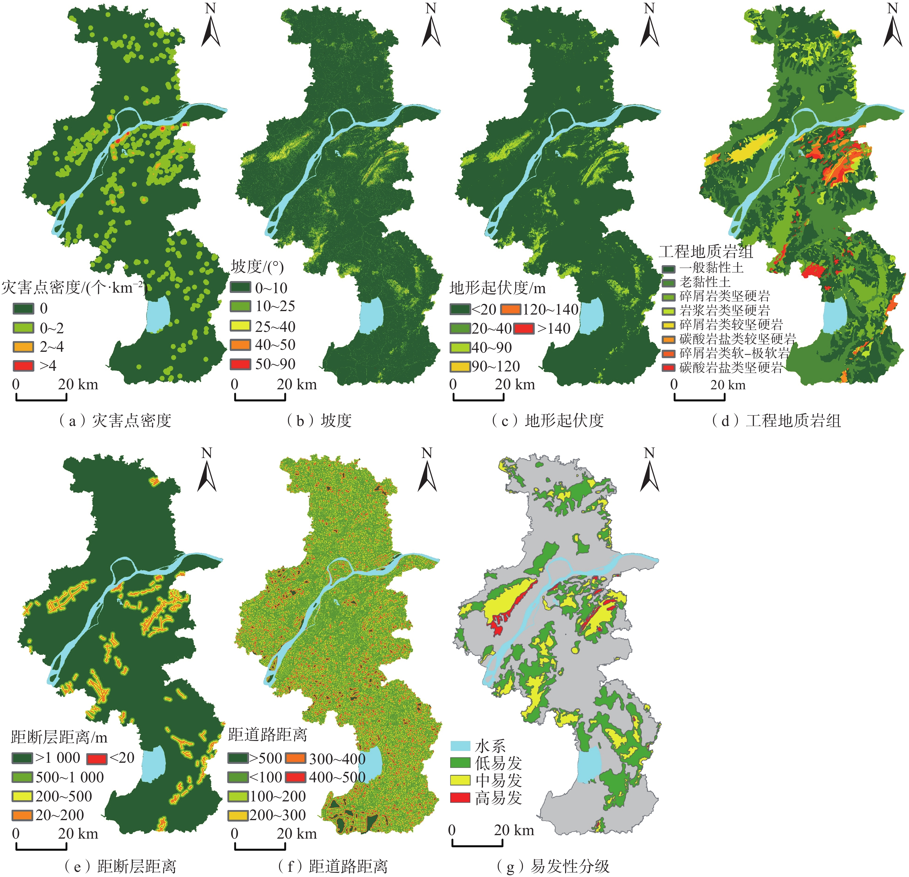
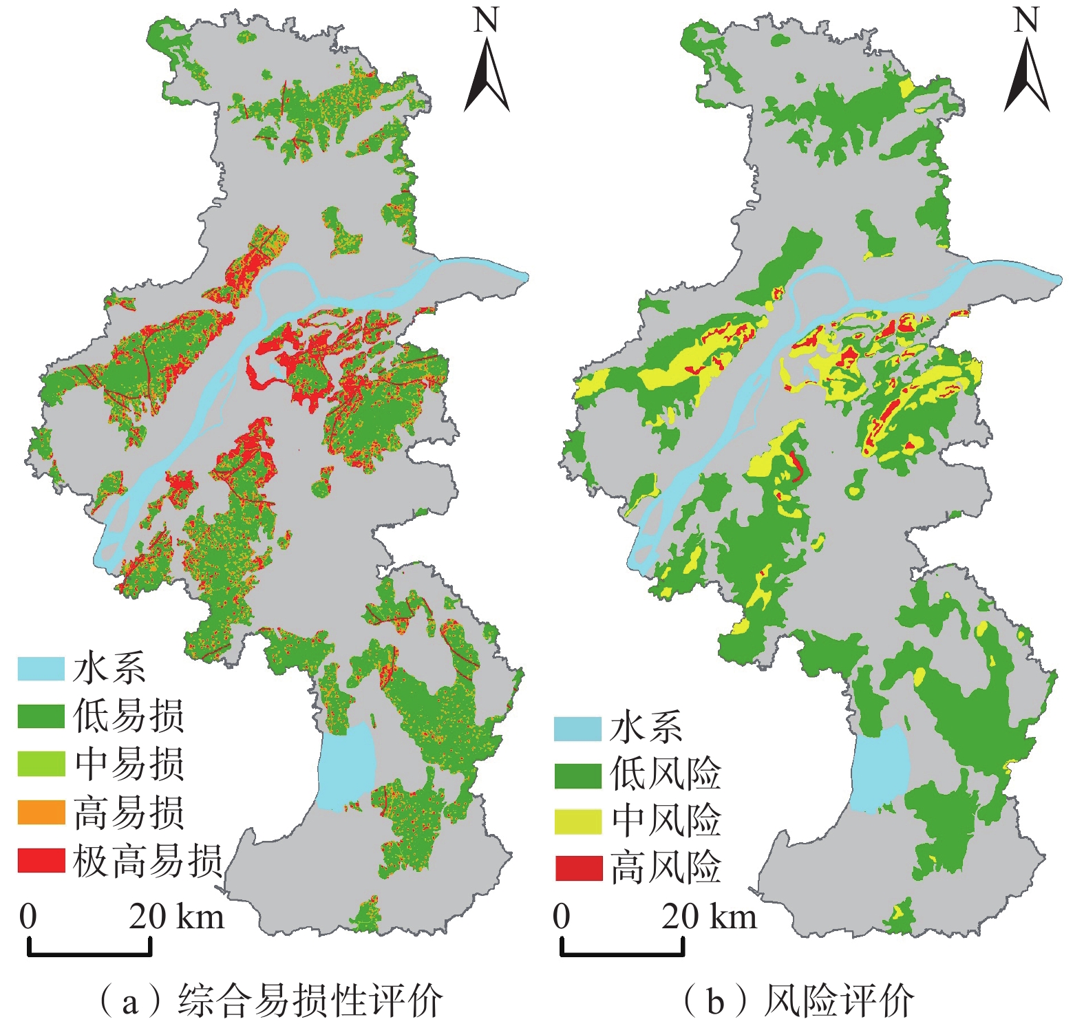
地质灾害风险评价是地质灾害风险管控的支撑与依据,对于科学防治地质灾害具有重要意义。以江苏南京为研究区,选取历史灾害点密度等影响因子开展易发性评价,以降雨量作为诱发因素开展危险性评价,结合承灾体易损性,分析划定地质灾害高、中、低三类风险区。结果表明:高风险区主要集中在沿江的老山、幕府山、紫金山、栖霞山以及青龙山等部分人员聚居的山前坡麓一带,面积51.3 km2,占比0.8%;中风险区主要集中在低山丘陵中人员较集中的区域,面积371.9 km2,占比5.6%;低风险区分布较广,位于其余低山丘陵岗地,面积1740.1 km2,占比26.4%。研究成果可有效支撑当地地质灾害防灾减灾以及国土空间规划应用。
Abstract:Geological disaster risk assessment serves as a crucial foundation for the risk management and control of such risks, playing a significant role in the scientific prevention and control of geological disasters. This study focuses on Nanjing, Jiangsu Province, and employs historical disaster point density and other influencing factors to evaluate the susceptibility of geological disasters. Rainfall is utilized as the triggering factor for conducting probability assessments. By considering the comprehensive vulnerability of the affected areas, the study analyzes and defines the high, medium, and low-risk zones for geological disasters. The findings reveal that high-risk zone primarily concentrates on populated piedmont slopes, including Laoshan, Mufu Mountain, Zijin Mountain, Qixia Mountain, and Qinglong Mountain, covering an area of 51.3 km2, accounting for 0.8% of the total area. Medium-risk zone is mainly located in areas with relatively concentrated populations in low mountains and hills, covering an area of 371.9 km2, accounting for 5.6% of the total area. Low-risk zone is more widely distributed, occupying the remaining low mountains and hills, covering an area of 1740.1 km2, accounting for 26.4% of the total area. The research results can effectively support disaster prevention, mitigation efforts related to geological disasters, and contribute to land space planning.
-
Key words:
- geological hazard /
- susceptibility /
- probability /
- vulnerability /
- risk assessment /
- Nanjing
-

-
表 1 地质灾害风险等级矩阵分析
Table 1. Analysis of geological hazard risk level matrix
风险性 危险性 极高 高 中 低 易
损
性极高 极高 极高 高 中 高 极高 高 中 中 中 高 高 中 低 低 高 中 低 低  下载: 导出CSV
表 2 评价因子信息量
Table 2. Information value of evaluation factors
评价因子 子类区间 信息量值 灾害点密度/(个·km−2) 0 −5.86 (0,2] 2.51 (2,4] 3.10 >4 4.12 坡度/(°) [0,10) −0.97 [10,25) 1.97 [25,40) 3.31 [40,50) 4.87 [50,90] 5.32 地形起伏度/m <20 −2.16 [20,40) 2.86 [40,90) 3.47 [90,120) 5.24 [120,140] 6.85 >140 7.13 工程地质岩组 老黏性土 −1.43 一般黏性土 −3.71 岩浆岩类坚硬岩 1.33 碎屑岩类软~极软岩 2.64 碳酸盐岩类坚硬岩 3.10 碳酸盐岩类较坚硬岩 2.40 碎屑岩类较坚硬岩 2.39 碎屑岩类坚硬岩 1.08 距断层距离/m <20 2.50 [20,200) 2.48 [200,500) 1.78 [500,1000] 0.90 >1000 −0.56 距道路距离/m <100 −0.19 [100,200] 0.06 (200,300] 0.53 (300,400] 0.65 (400,500] 0.59 >500 −2.19
下载: 导出CSV
表 3 地质灾害易发性分区评价判断矩阵
Table 3. Judgment matrix for assessing susceptibility zonation of geological hazards
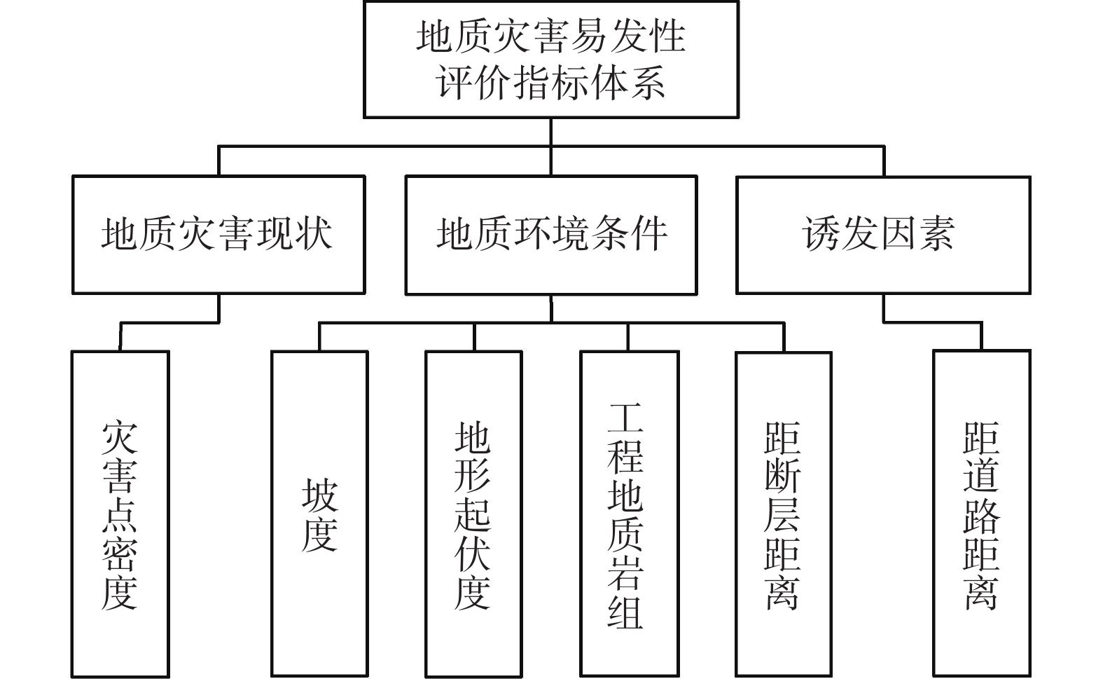
地质灾害易发性
分区评价地质环境条件 诱发因素 地质灾害现状 权重 地质环境条件 1 3 3 0.5936 诱发因素 1/3 1 2 0.2493 地质灾害现状 1/3 1/2 1 0.1571 判断矩阵一致性比例:0.0516;对总目标的权重:1.0000;
最大特征根:3.0536
下载: 导出CSV
表 4 地质环境条件判断矩阵
Table 4. Judgment matrix for geological environmental conditions
地质环境条件 坡度 工程地质岩组 地形起伏度 距断层距离 权重 坡度 1 1 1 1/2 0.2071 工程地质岩组 1 1 1 2 0.2929 地形起伏度 1 1 1 2 0.2929 距断层距离 2 1/2 1/2 1 0.2071 判断矩阵一致性比例:0.0923;对总目标的权重:0.5936;
最大特征根:4.2463
下载: 导出CSV
表 5 层次分析法计算各因子权重
Table 5. Calculation of factor weights using analytic hierarchy process (AHP)
影响因子 权重 历史灾害点密度 0.17 坡度 0.12 地形起伏度 0.17 工程地质岩组 0.17 距断层距离 0.12 距道路距离 0.25
下载: 导出CSV
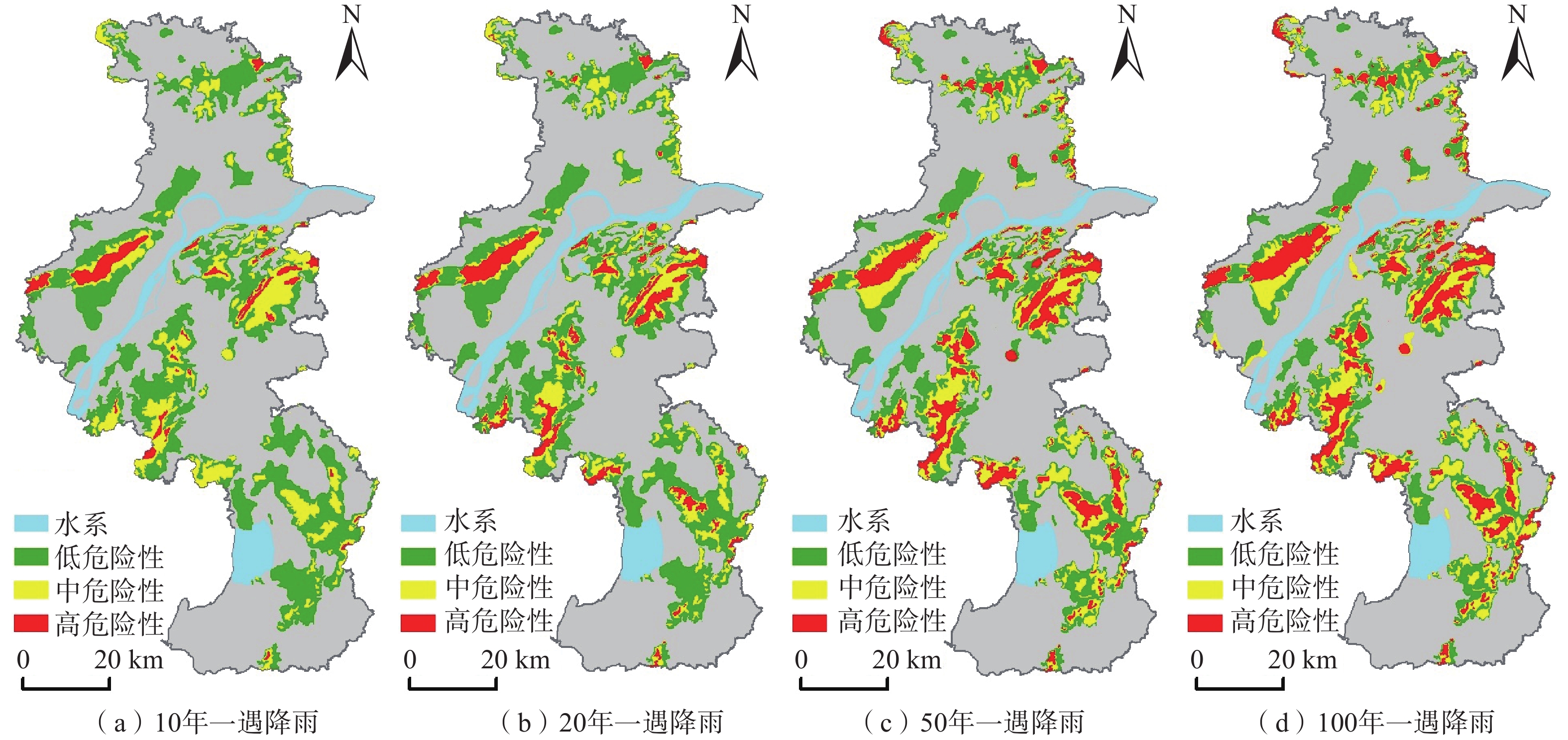
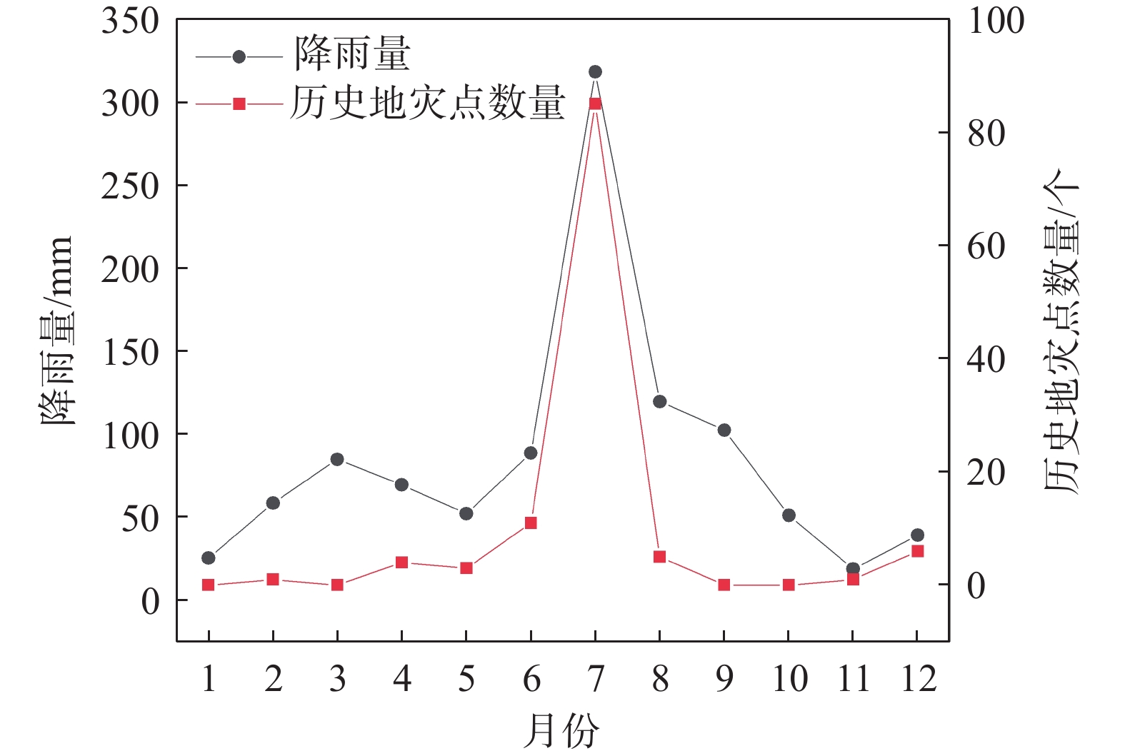
表 6 研究区不同重现期降雨量
Table 6. Precipitation distribution in different recurrence period in the study area
年均及不同重现期 降雨量/mm 年最大日降雨量均值 101 P=10% 157.92 P=5% 182.22 P=2% 212.84 P=1% 235.22
下载: 导出CSV
-
[1] 马晓峰,朱浩濛,张义顺,等. 省级地质灾害风险评价技术方法研究—以浙江省为例[J]. 浙江国土资源,2021(1):57 − 65. [MA Xiaofeng,ZHU Haomeng,ZHANG Yishun,et al. Study on the provincial risk assessment of geological disasters:A case of Zhejiang Province[J]. Zhejiang Land & Resources,2021(1):57 − 65. (in Chinese with English abstract)
MA Xiaofeng, ZHU Haomeng, ZHANG Yishun, et al. Study on the provincial risk assessment of geological disasters: a case of Zhejiang Province[J]. Zhejiang Land & Resources, 2021(1): 57-65. (in Chinese with English abstract)
[2] COTECCHIA V,MELIDORO G. Some principal geological aspects of the landslides of southern Italy[J]. Bulletin of the International Association of Engineering Geology - Bulletin De L’Association Internationale De Géologie De L’Ingénieur,1974,9(1):23 − 32.
[3] MEJÍA-NAVARRO M, WOHL E E, OAKS S D. Geological hazards, vulnerability, and risk assessment using GIS: Model for Glenwood Springs, Colorado[M]//Geomorphology and Natural Hazards. Amsterdam: Elsevier, 1994: 331 − 354.
[4] REMONDO J,BONACHEA J,CENDRERO A. A statistical approach to landslide risk modelling at basin scale:From landslide susceptibility to quantitative risk assessment[J]. Landslides,2005,2(4):321 − 328. doi: 10.1007/s10346-005-0016-x
[5] 吴树仁,石菊松,张春山,等. 地质灾害风险评估技术指南初论[J]. 地质通报,2009,28(8):995 − 1005. [WU Shuren,SHI Jusong,ZHANG Chunshan,et al. Preliminary discussion on technical guideline for geohazard risk assessment[J]. Geological Bulletin of China,2009,28(8):995 − 1005. (in Chinese)
WU Shuren, SHI Jusong, ZHANG Chunshan, et al. Preliminary discussion on technical guideline for geohazard risk assessment[J]. Geological Bulletin of China, 2009, 28(8)995-1005(in Chinese)
[6] 唐亚明,张茂省,李政国,等. 国内外地质灾害风险管理对比及评述[J]. 西北地质,2015,48(2):238 − 246. [TANG Yaming,ZHANG Maosheng,LI Zhengguo,et al. Review and comparison onInland and overseas geo-hazards risk management[J]. Northwestern Geology,2015,48(2):238 − 246. (in Chinese with English abstract)
TANG Yaming, (MAO)(SHENG Z, Xing), et al. Review and comparison onInland and overseas geo-hazards risk management[J]. Northwestern Geology, 2015, 48(2): 238-246. (in Chinese with English abstract)
[7] 王佳佳,殷坤龙,肖莉丽. 基于GIS和信息量的滑坡灾害易发性评价—以三峡库区万州区为例[J]. 岩石力学与工程学报,2014,33(4):797 − 808. [WANG Jiajia,YIN Kunlong,XIAO Lili. Landslide susceptibility assessment based on GIS and weighted information value:A case study of Wanzhou District,Three Gorges Reservoir[J]. Chinese Journal of Rock Mechanics and Engineering,2014,33(4):797 − 808. (in Chinese with English abstract)
WANG Jiajia, YIN Kunlong, XIAO Lili. Landslide susceptibility assessment based on GIS and weighted information value: a case study of Wanzhou district, Three Gorges Reservoir[J]. Chinese Journal of Rock Mechanics and Engineering, 2014, 33(4): 797-808. (in Chinese with English abstract)
[8] 施成艳,鹿献章,刘中刚. 基于GIS的安徽黄山市徽州区地质灾害易发性区划[J]. 中国地质灾害与防治学报,2016,27(1):136 − 140. [SHI Chengyan,LU Xianzhang,LIU Zhonggang. GIS-based zoning of geological hazard’s susceptibility in Huizhou District of Huangshan City of Anhui Province[J]. The Chinese Journal of Geological Hazard and Control,2016,27(1):136 − 140. (in Chinese with English abstract)
SHI Chengyan, LU Xianzhang, LIU Zhonggang. GIS-based zoning of geological hazard’s susceptibility in Huizhou district of Huangshan city of Anhui Province[J]. The Chinese Journal of Geological Hazard and Control, 2016, 27(1)136-140(in Chinese with English abstract)
[9] 李春燕,孟晖,张若琳,等. 中国县域单元地质灾害风险评估[J]. 水文地质工程地质,2017,44(2):160 − 166. [LI Chunyan,MENG Hui,ZHANG Ruolin,et al. Risk assessment of geo-hazard of China in County unit[J]. Hydrogeology and Engineering Geology,2017,44(2):160 − 166. (in Chinese with English abstract)
LI Chunyan, MENG Hui, ZHANG Ruolin, et al. Risk assessment of geo-hazard of China in County unit[J]. Hydrogeology and Engineering Geology, 2017, 44(2)160-166(in Chinese with English abstract)
[10] 理继红, 李伟. 南京市2021年度重要地质灾害隐患点核查简报[R]. 南京: 江苏省地质调查研究院, 2021
LI Jihong, LI Wei. Nanjing 2021 major geological disaster hidden points verification briefing[R]. Nanjing: Geological Survey of Jiangsu Province, 2021. (in Chinese)
[11] 刘宝生,宋京雷,郝社峰,等. 江苏宁镇地区典型下蜀土滑坡机理分析及应急处理措施[J]. 中国地质灾害与防治学报,2019,30(3):31 − 36. [LIU Baosheng,SONG Jinglei,HAO Shefeng,et al. Analysis and emergent control measures of the typical Xiashu loess landslides in Nanjing-Zhenjiang area,Jiangsu Province[J]. The Chinese Journal of Geological Hazard and Control,2019,30(3):31 − 36. (in Chinese with English abstract)
LIU Baosheng, SONG Jinglei, HAO Shefeng, et al. Analysis and emergent control measures of the typical Xiashu loess landslides in Nanjing-Zhenjiang area, Jiangsu Province[J]. The Chinese Journal of Geological Hazard and Control, 2019, 30(3)31-36(in Chinese with English abstract)
[12] 张敏,周灵,谭超,等. 复杂地层方形抗滑桩旋挖成孔工艺及工程应用[J]. 中国地质灾害与防治学报,2023,34(1):85 − 93. [ZHANG Min,ZHOU Ling,TAN Chao,et al. Techniques of rotary hole-drilling for square anti-slide piles in complex formation and its application[J]. The Chinese Journal of Geological Hazard and Control,2023,34(1):85 − 93. (in Chinese with English abstract)
[ZHANG Min, ZHOU Ling, TAN Chao, et al. Techniques of rotary hole-drilling for square anti-slide piles in complex formation and its application[J]. The Chinese Journal of Geological Hazard and Control, 2023, 34(1): 85-93.(in Chinese with English abstract)
[13] 杨洋,苏晶文,李云峰,等. 河谷平原跨区域工程地质层序厘定与平面分区方法—以安徽沿江地区为例[J]. 地质通报,2022,41(11):2019 − 2025. [YANG Yang,SU Jingwen,LI Yunfeng,et al. Stratigraphic ordering and regionalization of engineering geology in large area of valley plain:A case study along the Yangtze River in Anhui Province[J]. Geological Bulletin of China,2022,41(11):2019 − 2025. (in Chinese with English abstract)
[YANG Yang, SU Jingwen, LI Yunfeng, et al. Stratigraphic ordering and regionalization of engineering geology in large area of valley plain: a case study along the Yangtze River in Anhui Province[J]. Geological Bulletin of China, 2022, 41(11): 2019-2025.(in Chinese with English abstract)
[14] 周彤, 商广明, 翟亚峰. 路基砾类填料土动力特性影响因素试验分析[J]. 吉林大学学报(地球科学版),2021,51(5):1482 − 1489. [ZHOU Tong, SHANG Guangming, ZHAI Yafeng. Experimental analysis on influencing factors of dynamic characteristics of subgrade gravel packing soil[J]. Journal of Jilin University (Earth Science Edition),2021,51(5):1482 − 1489. (in Chinese with English abstract)
[ZHOU Tong, SHANG Guangming, ZHAI Yafeng. Experimental analysis on influencing factors of dynamic characteristics of subgrade gravel packing soil[J]. Journal of Jilin University (Earth Science Edition), 2021, 51(5): 1482-1489.(in Chinese with English abstract)
[15] 中国地质环境监测院. 地质灾害风险调查评价技术要求(1∶50000)[M]. 北京: 中国地质环境监测院, 2020
China Geological Environmental Monitoring Institute. The 1∶50000 Technical Requirements for Geological Hazard Risk Investigation and Evaluation[M]. Beijing: China Geological Environmental Monitoring Institute, 2010. (in Chinese)
[16] 杜国梁,杨志华,袁颖,等. 基于逻辑回归-信息量的川藏交通廊道滑坡易发性评价[J]. 水文地质工程地质,2021,48(5):102 − 111. [DU Guoliang,YANG Zhihua,YUAN Ying,et al. Landslide susceptibility mapping in the Sichuan-Tibet traffic corridor using logistic regression-information value method[J]. Hydrogeology & Engineering Geology,2021,48(5):102 − 111. (in Chinese with English abstract)
[DU Guoliang, YANG Zhihua, YUAN Ying, et al. Landslide susceptibility mapping in the Sichuan-Tibet traffic corridor using logistic regression-information value method[J]. Hydrogeology & Engineering Geology, 2021, 48(5): 102-111.(in Chinese with English abstract)
[17] 庞栋栋,刘刚,何敬,等. 基于层次分析法的甘肃省地质灾害风险评估分析[J]. 国土资源信息化,2021(6):41 − 47. [PANG Dongdong,LIU Gang,HE Jing,et al. Analysis of geological hazard risk assessment in Gansu Province based on analytic hierarchy process[J]. Land and Resources Informatization,2021(6):41 − 47. (in Chinese)
PANG Dongdong, LIU Gang, HE Jing, et al. Analysis of geological hazard risk assessment in Gansu Province based on analytic hierarchy process[J]. Land and Resources Informatization, 2021(6): 41-47. (in Chinese)
[18] 郑师谊,张绪教,杨艳,等. 层次分析法在滇西怒江河谷潞江盆地段崩塌与滑坡地质灾害危险性评价中的应用[J]. 地质通报,2012,31(增刊 1):356 − 365. [ZHENG Shiyi,ZHANG Xujiao,YANG Yan,et al. The application of analytic hierarchy process to the danger evaluation of collapse and slide in Lujiang Basin segment of Nujiang valley, western Yunnan Province[J]. Geological Bulletin of China,2012,31(Sup 1):356 − 365. (in Chinese with English abstract)
[ZHENG Shiyi, ZHANG Xujiao, YANG Yan, et al. The application of analytic hierarchy process to the danger evaluation of collapse and slide in Lujiang Basin segment of Nujiang valley, western Yunnan Province[J]. Geological Bulletin of China, 2012, 31(Sup 1): 356-365.(in Chinese with English abstract)
[19] 闫佰忠, 孙剑, 王昕洲, 等. 基于GIS-FAHP的石家庄市地下水源热泵适宜性分区[J]. 吉林大学学报(地球科学版),2021,51(4):1172 − 1181. [YAN Baizhong, SUN Jian, WANG Xinzhou, et al. Suitability zoning of groundwater source heat pump in Shijiazhuang based on GIS-FAHP[J]. Journal of Jilin University (Earth Science Edition),2021,51(4):1172 − 1181. (in Chinese with English abstract)
[YAN Baizhong, SUN Jian, WANG Xinzhou, et al. Suitability zoning of groundwater source heat pump in Shijiazhuang based on GIS-FAHP[J]. Journal of Jilin University (Earth Science Edition), 2021, 51(4): 1172-1181.(in Chinese with English abstract)
[20] 李军,周成虎. 基于栅格GIS滑坡风险评价方法中格网大小选取分析[J]. 遥感学报,2003(2):86 − 92,161. [LI Jun,ZHOU Chenghu. Appropriate grid size for terrain based landslide risk assessment in lantau island,hong kong[J]. Journal of Remote Sensing,2003(2):86 − 92,161. (in Chinese with English abstract)
LI Jun, ZHOU Chenghu. Appropriate grid size for terrain based landslide risk assessment in lantau island, hong kong[J]. Journal of Remote Sensing, 2003(2): 86-92, 161. (in Chinese with English abstract)])
[21] 屠水云,张钟远,付弘流,等. 基于CF与CF-LR模型的地质灾害易发性评价[J]. 中国地质灾害与防治学报,2022,33(2):96 − 104. [TU Shuiyun,ZHANG Zhongyuan,FU Hongliu,et al. Geological hazard susceptibility evaluation based on CF and CF-LR model[J]. The Chinese Journal of Geological Hazard and Control,2022,33(2):96 − 104. (in Chinese with English abstract)
TU Shuiyun, ZHANG Zhongyuan, FU Hongliu, et al. Geological hazard susceptibility evaluation based on CF and CF-LR model[J]. The Chinese Journal of Geological Hazard and Control, 2022, 33(2): 96-104. (in Chinese with English abstract)
-

图(6)
表(6)
计量
- 文章访问数: 346
- PDF下载数: 12
- 施引文献: 0