

Assessment of landslide hazard risk in Kenya based on different statistical models
-
摘要:
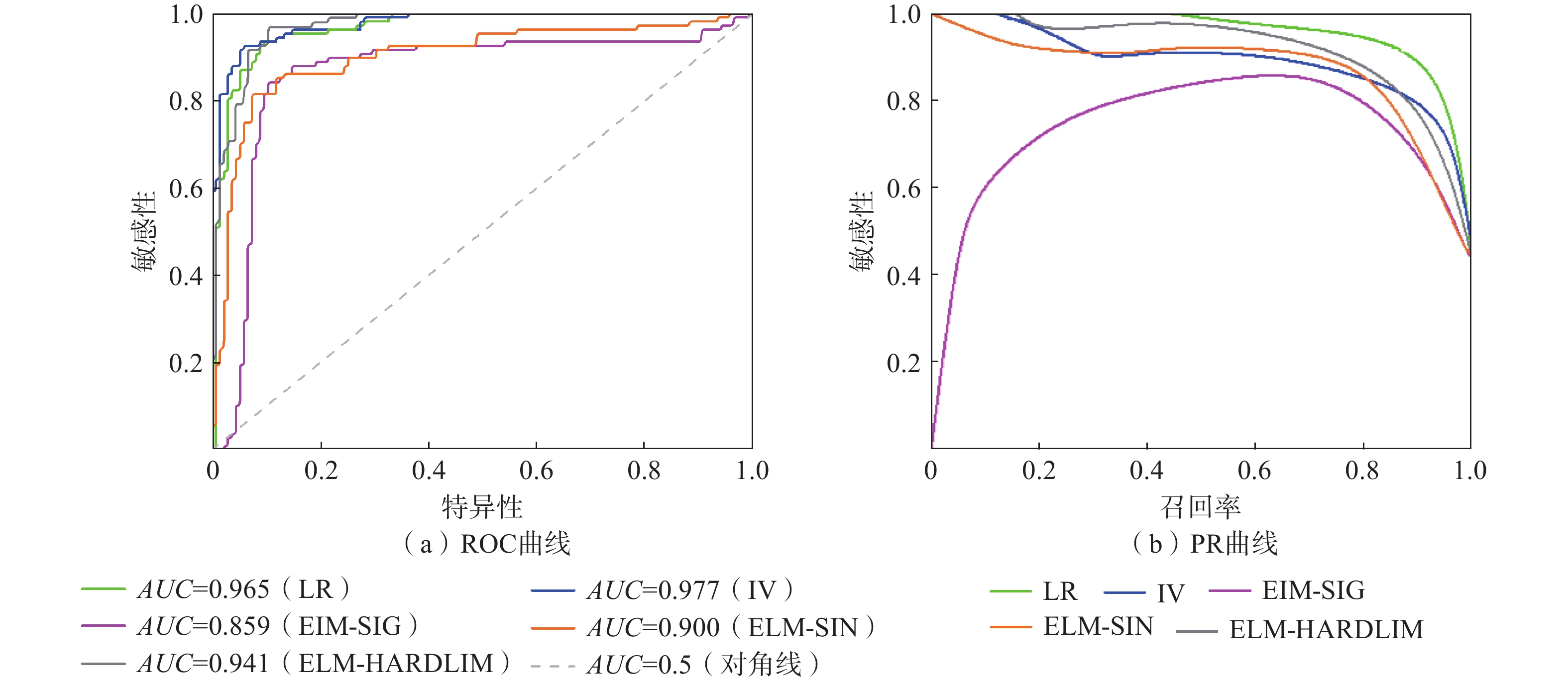
肯尼亚是我国“一带一路”倡议在东非重要支点。受高原裂谷地形和显著的雨旱季节影响,肯尼亚地质灾害频发。本文以肯尼亚的历史滑坡数据为样本,选取高度、坡度、坡向、地貌、平面曲率、土壤类型、年平均降雨量、水流强度指数、地形湿度指数及土地利用类型作为评价指标,分别基于信息量模型(IV)、逻辑回归模型(LR)和极限学习机模型(ELM)对肯尼亚滑坡灾害进行危险性区划,其中ELM分别考虑了sigmoid 函数、正弦函数和对称阈值型传输函数作为激活函数进行讨论。主要结论如下:(1)肯尼亚滑坡灾害高危险性及以上等级区域集中分布在西南部的高原和高原—裂谷过渡地带;(2)采用ROC曲线对模型精度进行评价,各模型的AUC值分别为0.977(IV)、0.965(LR)、0.859(ELM-SIG)、0.900(ELM-SIN)、0.941(ELM-HARDLIM),评价结果有效;(3)综合PR曲线结果判定,LR模型的召回率和精确率都处于较高的水平,优于其他模型;(4)肯尼亚内罗毕省(Nairobi)、中部省(Central)、尼扬扎省(Nyanza)和西部省(Western)四个省份高危险性区域占比较大。
Abstract:Kenya is an important fulcrum of China's Belt and Road initiative in east Africa. However, due to its plateau rift terrain and aboriginal rain and drought season, geological disasters occur frequently in Kenya. The study used historical landslide data in Kenya as samples and selected several evaluation indexes, including elevation, slope, aspect, landform, plane curvature, soil type, annual average rainfall, stream power index, terrain witness index, and land use type. The landslide risk in Kenya was evaluated based on the information value model (IV), logistic regression model (LR), and extreme learning machine model (ELM), with the ELM model considering SIG, SIN, and HARDLIM functions as activation functions for discussion. The main findings are as follows: (1) The high-risk and above-grade areas of landslide disasters in Kenya are mainly concentrated in the plateau and plateau-rift transition zone in the southwest. (2) The ROC curve was used to evaluate the accuracy of the models, and the AUC values of the 0.977(IV), 0.965(LR), 0.859(ELM-SIG), 0.900(ELM-SIN), and 0.941(ELM-HARDLIM) models illustrate their validity. (3) Considering the PR curve results comprehensively, the recall rate and precision rate of the LR model are at a high level, marking it better than other models. (4) Nairobi, Central, Nyanza and Western provinces in Kenya account for a significant proportion of the high-risk and above-grade areas of landslide disasters.
-
Key words:
- Kenya /
- risk /
- information value /
- logistic regression /
- machine learning
-

-
表 1 信息量模型系数
Table 1. Summary table for coefficients of the IV model
因素 因子分级 信息量 因素 因子分级 信息量 高程
/m0~50 −1.341 坡度/(°) 0~5 −2.212 50~200 0.000 5~15 0.315 200~500 −1.941 15~25 1.552 500~1000 −2.813 25~35 3.671 1000~2000 0.452 35~45 4.889 >2000 2.316 >45 5.356 坡向 平 0.000 地貌 洼地 1.547 北 0.282 山麓 0.340 东北 0.322 高原 1.389 东北 0.183 平原 −2.277 东南 −0.032 谷底 0.000 南 −0.215 悬崖 1.062 西南 −0.707 丘陵 0.913 西 −0.089 山谷 2.353 西北 0.052 山脊 1.476 土壤
类型黏土 −0.124 水体 0.000 壤土 0.115 年平均
降雨量
/mm<400 −1.762 砂土 −1.948 400~800 −0.729 高含量黏土 0.450 800~1200 0.850 地形
湿度
指数7~12 1.666 1200~1600 2.240 12~14 −1.423 1600~2000 0.503 14−16 −2.041 2000~2400 0.607 16~20 −1.785 >2400 0.000 20~32 −2.319 水流
能力
指数2~5 −2.889 土地
利用
类型农业用地 0.800 5~7 −1.562 荒地 −1.365 7~9 0.972 灌木丛 −1.570 9~12 1.107 林地 2.043 12~23 0.250 草地 0.000 平面
曲率凸 −0.089 沼泽 0.000 平 −1.026 城镇 2.148 凹 0.187  下载: 导出CSV
表 2 逻辑回归模型系数
Table 2. Summary table for coefficients of the LR model
因素 系数 因素 系数 高程 1.683 土壤类型 −0.048 坡度 0.754 地形湿度指数 −1.125 坡向 −0.097 水流能力指数 1.481 地貌 0.229 年平均降雨量 1.466 平面曲率 0.047 土地利用类型 0.026
下载: 导出CSV
表 3 不同模型灾害分布统计结果
Table 3. Statistical results of disasters distribution for different models
危险性分区评估模型 极低危险性 低危险性 中危险性 高危险性 极高危险性 LR模型 面积占比/% 72.700 11.900 5.500 4.400 5.400 数量占比/% 2.570 0.930 1.170 10.510 84.810 灾害比重 0.035 0.078 0.213 2.389 15.705 IV模型 面积占比/% 35.300 29.800 16.9000 11.000 6.900 数量占比/% 0.930 0.930 2.8000 17.520 77.800 灾害比重 0.026 0.031 0.1657 1.593 11.275 ELM-SIG 面积占比/% 1.300 76.300 19.400 1.100 1.900 数量占比/% 1.870 8.410 88.080 1.170 0.470 灾害比重 1.438 0.110 4.540 1.064 0.247 ELM-SIN 面积占比/% 1.100 38.300 43.600 12.800 4.200 数量占比/% 0.700 2.800 9.110 33.880 53.500 灾害比重 0.636 0.073 0.208 2.647 12.738 ELM-HARDLIM 面积占比/% 5.200 34.300 34.500 18.000 8.000 数量占比/% 0.930 0.930 2.800 17.520 77.800 灾害比重 0.178 0.027 0.081 0.973 9.725
下载: 导出CSV
-
[1] BATALA L K,YU Wangxing,KHAN A,et al. Natural disasters' influence on industrial growth,foreign direct investment,and export performance in the South Asian region of Belt and road initiative[J]. Natural Hazards,2021,108(2):1853 − 1876. doi: 10.1007/s11069-021-04759-w
[2] BAI Yuanli,WIERZBICKI T. Application of extended Mohr-Coulomb criterion to ductile fracture[J]. International Journal of Fracture,2010,161(1):1 − 20. doi: 10.1007/s10704-009-9422-8
[3] ROGERS J D,CHUNG J. Applying Terzaghi’s method of slope characterization to the recognition of Holocene land slippage[J]. Geomorphology,2016,265:24 − 44. doi: 10.1016/j.geomorph.2016.04.020
[4] AHMED A,UGAI K,YANG Qing qing. Assessment of 3D slope stability analysis methods based on 3D simplified janbu and hovland methods[J]. International Journal of Geomechanics,2012,12(2):81 − 89. doi: 10.1061/(ASCE)GM.1943-5622.0000117
[5] WANG Chun ming,LIU Chun yuan,WU Mai,et al. Research on soil-like slope instability based on FEM strength reduction[J]. Applied Mechanics and Materials,2013,438/439:1244 − 1248. doi: 10.4028/www.scientific.net/AMM.438-439.1244
[6] 吴信才,白玉琪,郭玲玲. 地理信息系统(GIS)发展现状及展望[J]. 计算机工程与应用,2000,36(4):8 − 9. [WU Xincai,BAI Yuqi,GUO Lingling. Development and prospect of geographic information system[J]. Computer Engineering and Applications,2000,36(4):8 − 9. (in Chinese with English abstract)
WU Xincai, BAI Yuqi, GUO Lingling. Development and prospect of geographic information system[J]. Computer Engineering and Applications, 2000, 36(4): 8-9. (in Chinese with English abstract)
[7] SON J,SUH J,PARK H D. GIS-based landslide susceptibility assessment in Seoul,South Korea,applying the radius of influence to frequency ratio analysis[J]. Environmental Earth Sciences,2016,75(4):310. doi: 10.1007/s12665-015-5149-1
[8] 屠水云,张钟远,付弘流,等. 基于CF与CF-LR模型的地质灾害易发性评价[J]. 中国地质灾害与防治学报,2022,33(2):96 − 104. [TU Shuiyun,ZHANG Zhongyuan,FU Hongliu,et al. Geological hazard susceptibility evaluation based on CF and CF-LR model[J]. The Chinese Journal of Geological Hazard and Control,2022,33(2):96 − 104. (in Chinese with English abstract)
TU Shuiyun, ZHANG Zhongyuan, FU Hongliu, et al. Geological hazard susceptibility evaluation based on CF and CF-LR model[J]. The Chinese Journal of Geological Hazard and Control, 2022, 33(2): 96-104. (in Chinese with English abstract)
[9] 刘福臻,王灵,肖东升. 机器学习模型在滑坡易发性评价中的应用[J]. 中国地质灾害与防治学报,2021,32(6):98 − 106. [LIU Fuzhen,WANG Ling,XIAO Dongsheng. Application of machine learning model in landslide susceptibility evaluation[J]. The Chinese Journal of Geological Hazard and Control,2021,32(6):98 − 106. (in Chinese with English abstract)
LIU Fuzhen, WANG Ling, XIAO Dongsheng. Application of machine learning model in landslide susceptibility evaluation[J]. The Chinese Journal of Geological Hazard and Control, 2021, 32(6)98-106(in Chinese with English abstract)
[10] LIU Rui,LI Luyao,PIRASTEH S,et al. The performance quality of LR,SVM,and RF for earthquake-induced landslides susceptibility mapping incorporating remote sensing imagery[J]. Arabian Journal of Geosciences,2021,14(4):1 − 15.
[11] WANG Xi,WANG Shuangyin,QI Jiashuo. Open-channel landslide hazard assessment based on AHP and fuzzy comprehensive evaluation[J]. Water Supply,2020,20(8):3687 − 3696. doi: 10.2166/ws.2020.176
[12] 商冬凡,唐梦芸,苗雷强,等. 城市道路空洞隐患风险评估方法应用研究[J]. 市政技术,2022,40(11):37 − 42. [SHANG Dongfan,TANG Mengyun,MIAO Leiqiang,et al. Risk Assessment of Operation and Maintenance Stage of Utility Tunnel based on Combination Weighting-Improved Risk Matrix Method[J]. Journal of Municipal Technology,2022,40(11):37 − 42. (in Chinese with English abstract)
[Shang Dongfan, Tang Mengyun, Miao Leiqiang, Shi Jiahao, Zhou Siqing. Risk Assessment of Operation and Maintenance Stage of Utility Tunnel based on Combination Weighting-Improved Risk Matrix Method [J]. Journal of Municipal Technology, 2022,40(11): 37-42. (in Chinese with English abstract)
[13] 张俊,殷坤龙,王佳佳,等. 三峡库区万州区滑坡灾害易发性评价研究[J]. 岩石力学与工程学报,2016,35(2):284 − 296. [ZHANG Jun,YIN Kunlong,WANG Jiajia,et al. Evaluation of landslide susceptibility for Wanzhou district of Three Gorges Reservoir[J]. Chinese Journal of Rock Mechanics and Engineering,2016,35(2):284 − 296. (in Chinese with English abstract)
Zhang Jun, Yin Kunlong, Wang Jiajia, et al. Evaluation of landslide susceptibility for Wanzhou district of Three Gorges Reservoir[J]. Chinese Journal of Rock Mechanics and Engineering, 2016, 35(2): 284-296. (in Chinese with English abstract)
[14] CHEN Wei,LI Wenping,CHAI Huichan,et al. GIS-based landslide susceptibility mapping using analytical hierarchy process (AHP) and certainty factor (CF) models for the Baozhong region of Baoji City,China[J]. Environmental Earth Sciences,2016,75(1):63. doi: 10.1007/s12665-015-4795-7
[15] 刘璐瑶,高惠瑛,李照. 基于CF与Logistic回归模型耦合的永嘉县滑坡易发性评价[J]. 中国海洋大学学报(自然科学版),2021,51(10):121 − 129. [LIU Luyao,GAO Huiying,LI Zhao. Landslide susceptibility assessment based on coupling of CF model and logistic regression model in Yongjia County[J]. Periodical of Ocean University of China,2021,51(10):121 − 129. (in Chinese with English abstract)
LIU Luyao, GAO Huiying, LI Zhao. Landslide susceptibility assessment based on coupling of CF model and logistic regression model in Yongjia County[J]. Periodical of Ocean University of China, 2021, 51(10)121-129(in Chinese with English abstract)
[16] 国家市场监督管理总局, 国家标准化管理委员会. 地质灾害危险性评估规范: GB/T 40112—2021[S]. 北京: 中国标准出版社, 2021
Standardization Administration of the People's Republic of China. Specifications for risk assessment of geological hazard: GB/T 40112—2021[S]. Beijing: Standards Press of China, 2021. (in Chinese)
[17] 杨先全,周苏华,邢静康,等. 肯尼亚滑坡灾害分布特征及敏感性区划[J]. 中国地质灾害与防治学报,2019,30(5):65 − 74. [YANG Xianquan,ZHOU Suhua,XING Jingkang,et al. Distribution patterns and susceptibility mapping of landslides in Kenya[J]. The Chinese Journal of Geological Hazard and Control,2019,30(5):65 − 74. (in Chinese with English abstract)
YANG Xianquan, ZHOU Suhua, XING Jingkang, et al. Distribution patterns and susceptibility mapping of landslides in Kenya[J]. The Chinese Journal of Geological Hazard and Control, 2019, 30(5)65-74(in Chinese with English abstract)
[18] 朱丛瑞. 肯尼亚建国后的环境问题研究[D]. 昆明: 云南师范大学, 2021
ZHU Congrui. Research on environmental problems after the founding of Kenya[D]. Kunming: Yunnan Normal University, 2021. (in Chinese with English abstract)
[19] 肯尼亚信息、通信和技术部.滑坡统计资料[M/OL]. [2015-5-18]. https://www.ict.go.ke/wp-content/uploadsKenya.
Ministry of Information, Communication and Technology of Kenya. Landslide Statistics[M/OL]. [2015-5-18]. (in Chinese)
[20] 全球毁灭性滑坡数据库.肯尼亚地区滑坡数据[M/OL]. [2019-6-18]. https://blogs.agu.org/landslideblog/.
Global Database of Fatal Landslides.Kenya Historical Landslide Data[M/OL]. [2019-6-18]. (in Chinese)
[21] BROECKX J,VANMAERCKE M,DUCHATEAU R,et al. A data-based landslide susceptibility map of Africa[J]. Earth-Science Reviews,2018,185:102 − 121. doi: 10.1016/j.earscirev.2018.05.002
[22] NASA 地球公开数据. ASTERGDEMV2卫星全球高程公开共享数据[M/OL]. [2013-11-30].https://visibleearth.nasa.gov/.
NASA Earth Open Data. ASTERGDEMV2 satellite global elevation data[M/OL]. [2013-11-30]. (in Chinese)
[23] 开放非洲数据库. 肯尼亚地区地表径流、地貌、年降雨量等共享数据[M/OL]. [2014-1-20]. www.Openafrica.org
Open Africa Database. Shared data on surface runoff, landforms, and annual rainfall in Kenya [M/OL]. [2014-1-20]. (in Chinese)
[24] 世界资源研究所公开数据. 肯尼亚地区土地利用类型共享数据[M/OL]. [2014-1-20]. www.wri.org.
World Resources Institute Open Data. Shared data on land use types in Kenya[M/OL]. [2014-1-20]. (in Chinese)
[25] CHENG Yongzhen,HUANG Xiaoming. Effect of mineral additives on the behavior of an expansive soil for use in highway subgrade soils[J]. Applied Sciences,2018,9(1):30. doi: 10.3390/app9010030
[26] SWETS J A. Measuring the accuracy of diagnostic systems[J]. Science,1988,240(4857):1285 − 1293. doi: 10.1126/science.3287615
-


图(7)
表(3)
计量
- 文章访问数: 1159
- PDF下载数: 199
- 施引文献: 0