

Landslide susceptibility evaluation in Fengjie County based on slope units extracted using the MIA-HSU method
-
摘要:
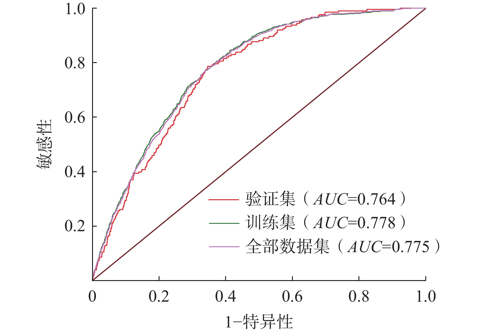
栅格单元难以表征斜坡的形态与边界,以其为制图单元的滑坡易发性评价结果无法精细化描述自然斜坡的滑坡易发程度。而形态图像分析-均匀坡度单元(morphological image analysis-homogeneous slope unit,MIA-HSU)方法提取的斜坡单元可以表征斜坡的形态与边界,并能克服传统方法提取的斜坡单元存在坡度突变的缺陷。文章使用MIA-HSU为滑坡易发性评价提供制图单元。以重庆市奉节县为研究区,选取高程、坡度、坡向、归一化植被指数、归一化建筑指数、起伏度、距河流距离、距道路距离、岩性、剖面曲率、土地利用、地形湿度指数、水流功率指数、泥沙输移指数、地形位置指数等15个指标,采用信息量法评价奉节县的滑坡易发性程度。评价结果表明,滑坡易发性越高的区域灾害点密度越大,1950—2015年参加训练的滑坡点落在极高易发区和高易发区中的比例为 94.13%,成功率曲线法对滑坡易发性评价结果的测试精度为0.764,表明评价结果与实际滑坡分布情况基本吻合;2018年以后发生的未参与模型训练的滑坡点中超过90%落在高易发区和极高易发区,说明易发性评价结果具有较高的泛化性。研究结果可为研究区滑坡隐患点识别和灾害防治提供科学参考。
Abstract:Grid units have limitations in accurately delineating the morphology and boundaries of slopes, and when used as mapping units in landslide susceptibility evaluation, they cannot accurately describe the landslide susceptibility of natural slopes. Investigations have shown that the morphological image analysis-homogeneous slope unit(MIA-HSU) method provides slope units that are more homogenous in slope angle and aspect, addressing the deficiencies of traditional methods. In this study, MIA-HSU was applied to provide mapping units for landslide susceptibility evaluation. Taking Fengjie County, Chongqing as the study area, 15 factors including elevation, slope angle, slope aspect, normalized difference vegetation index (NDVI), normalized difference built-up index(NDBI), topographic relief, distance from rivers, distance from roads, lithology, profile curvature, land use, topographic wetness index (TWI), stream power index (SPI), sediment transport index (STI), and topographic position index(TPI) were selected to evaluate landslide susceptibility using the information value method. The evaluation results indicated that areas with higher landslide susceptibility exhibited a greater density of disaster points. During the 1950 to 2015 period, 94.13% of the landslide points used for training fell within the extremely high and high susceptibility zones. The accuracy of landslide susceptibility evaluation was further verified using the success rate curve method. The accuracy of the verification set was 0.764, indicating that the evaluation results were generally consistent with the actual landslide distribution. Over 90% of the landslide points occurring after 2018 (which were not used in training) were located in the high and extremely high susceptibility zones, demonstrating the model’s high generalization ability. The findings provide a scientific basis for identifying potential landslide hazards and for landslide prevention and mitigation in the study area.
-
Key words:
- landslide /
- slope unit /
- information value method /
- susceptibility evaluation /
- MIA-HSU method
-

-
表 1 数据源
Table 1. Date sources
数据名称 数据
类型数据
分辨率数据来源 GDEM V3 栅格 30 m 地理空间数据云 土地利用 栅格 30 m 全国地理信息资源目录服务系统 1960—2021年
平均降雨量栅格 1 km 资源环境科学与数据中心 1∶25万道路图 矢量 全国地理信息资源目录服务系统 NDVI/NDBI 栅格 30 m 地理空间数据云, Landsat-8 1∶25万岩性 矢量 地理空间数据云  下载: 导出CSV
表 2 各因子图层分类情况及其对应的信息量值
Table 2. Classification and corresponding information values of each factor layer
评价因子 各因子图层各类别对应值 信息增益 高程 分类范围 61~382 382~613 613~816 816~ 1006 1006 ~1204 1204 ~1423 1423 ~1694 1694 ~2123 0.0318 信息量 0.5766 0.5850 0.4827 0.1558 − 0.3198 − 1.5944 − 2.2642 − 3.9106 坡度 分类范围 0~9 9~15 15~20 20~25 25~31 31~38 38~46 46~76 0.0033 信息量 − 0.0344 0.2191 0.2352 0.0776 − 0.1427 − 0.3473 − 0.4424 − 0.6035 坡向 分类范围 平面 北 东北 东 东南 南 西南 西 西北 0.0014 信息量 − 0.1360 − 0.0340 − 0.0273 − 0.0882 − 0.0429 0.1840 0.2527 − 0.0528 − 0.2337 NDVI 分类范围 <−0.12 −0.12~0.12 0.12~0.26 0.26~0.37 0.37~0.47 0.47~0.55 0.55~0.63 >0.63 0.0004 信息量 0.0866 − 0.4897 − 0.0491 − 0.0943 0.0181 0.0870 0.0361 − 0.0686 NDBI 分类范围 <−0.48 −0.48~−0.4 −0.4~−0.32 −0.32~−0.25 −0.25~−0.18 −0.18~−0.11 −0.11~0 >0 0.0023 信息量 − 0.2254 − 0.3748 − 0.1986 − 0.0108 0.1399 0.2043 0.0449 − 0.5934 地形
起伏度分类范围 119~303 303~403 403~492 492~577 577~665 665~773 773~932 932~ 1365 0.0084 信息量 − 1.1694 − 0.1943 0.1916 0.2921 0.1689 − 0.1057 − 0.9061 − 1.5700 距河流
距离分类范围 0~300 300~600 600~900 900~ 1200 1200 ~1500 > 1500 0.0038 信息量 0.2621 0.2779 0.1386 0.0197 − 0.0923 − 0.3525 距道路
距离分类范围 0~300 300~600 600~900 900~ 1200 1200 ~1500 > 1500 0.0041 信息量 0.2206 − 0.0500 − 0.1985 − 0.5006 − 0.6647 − 0.8397 岩性 分类范围 黏土、砂砾石
多层土体较软弱岩组 较坚硬岩组 较软弱碳酸
盐岩组坚硬碳酸
盐岩组0.1667 信息量 − 0.8507 0.6779 0.5356 − 2.3212 − 0.5198 年平均
降雨量分类范围 1069 ~1151 1151 ~1207 1207 ~1256 1256 ~1302 1302 ~1362 1362 ~1433 1433 ~1508 1508 ~1597 0.03261 信息量 0.5001 0.6229 0.4243 0.0279 − 0.6333 − 2.2480 − 2.8662 − 2.6848 平面曲率 分类范围 −15.08~−2 −2~−1.01 −1.01~−0.44 −0.44~0.13 0.13~0.7 0.7~1.41 1.41~3.54 3.54~21.31 0.0021 信息量 − 0.7206 − 0.3646 − 0.0618 0.1533 0.0563 − 0.2797 − 0.6510 − 1.2357 剖面曲率 分类范围 −19.99~−3.81 −3.81~−1.7 −1.7~−0.79 −0.79~−0.18 −0.18~0.42 0.42~1.33 1.33~3.44 3.44~18.71 0.0023 信息量 − 0.8830 − 0.5894 − 0.2641 0.0725 0.1688 − 0.0846 − 0.4615 − 0.7636 土地利用 分类范围 耕地 森林 草丛 水体 人造表面 0.0166 信息量 0.5734 − 0.4913 0.0324 − 0.0888 1.5409 TRI 分类范围 1~1.05 1.05~1.11 1.11~1.18 1.18~1.28 1.28~1.42 1.42~1.64 1.64~2.09 2.09~4.14 0.0029 信息量 0.1731 0.1071 − 0.1787 − 0.3670 − 0.4465 − 0.5403 − 0.8319 − 0.3162 TWI 分类范围 1.83~4.36 4.36~5.58 5.58~6.99 6.99~8.77 8.77~11.11 11.11~13.64 13.64~17.1 17.11~25.8 0.0012 信息量 − 0.1798 0.0429 0.1188 0.1837 0.1147 − 0.2764 − 0.3209 0.0633 SPI 分类范围 −3.84~0.39 0.39~2.16 2.16~3.31 3.31~4.54 4.54~5.96 5.96~7.81 7.81~10.73 10.73~18.76 0.0006 信息量 − 0.5358 0.0877 − 0.0630 0.0048 0.0155 0.0983 0.1487 0.2851 STI 分类范围 0~6 6~26 26~58 58~102 102~163 163~246 246~371 371~818 0.0001 信息量 − 0.0149 0.0602 0.1703 0.2320 0.3209 0.4030 0.6023 0.9031 TPI 分类范围 −256~−70 −70~−44 −44~−26 −26~−10 −10~7 7~23 23~45 45~211 0.0023 信息量 − 0.4933 − 0.1900 − 0.0932 0.0435 0.2009 0.0390 − 0.2395 − 0.6485
下载: 导出CSV
表 3 研究区滑坡易发性区划统计表
Table 3. Landslide susceptibility zoning statistics for the study area
易发性区 面积
/km2面积占比
/%灾害点
个数/处灾害占比
/%灾害点密度
/(处·km−2)极低易发区 299.05 7.29 4 0.38 0.01 低易发区 391.29 9.54 10 0.95 0.03 中易发区 864.88 21.10 48. 4.55 0.06 高易发区 1376.22 33.57 317 30.05 0.23 极高易发区 1168.38 28.50 676 64.08 0.58
下载: 导出CSV
表 4 研究区灾害点统计表
Table 4. Statistical table of disaster sites in the study area
易发性区 灾害点个数/处 灾害占比/% 极低易发区 0 0 低易发区 2 1.82 中易发区 4 3.64 高易发区 32 29.09 极高易发区 72 65.45
下载: 导出CSV
-
[1] 孙乾征,张华湘,向刚,等. 贵州省开阳县田坝寨滑坡形成机理研究[J]. 人民长江,2021,52(增刊1):96 − 100. [SUN Qianzheng,ZHANG Huaxiang,XIANG Gang,et al. Study on formation mechanism of Tianbazhai landslide in Kaiyang County,Guizhou Province[J]. Yangtze River,2021,52(Sup 1):96 − 100. (in Chinese)]
SUN Qianzheng, ZHANG Huaxiang, XIANG Gang, et al. Study on formation mechanism of Tianbazhai landslide in Kaiyang County, Guizhou Province[J]. Yangtze River, 2021, 52(Sup 1): 96 − 100. (in Chinese)
[2] 吴宏阳,周超,梁鑫,等. 基于XGBoost模型的三峡库区燕山乡滑坡易发性评价与区划[J]. 中国地质灾害与防治学报,2023,34(5):141 − 152. [WU Hongyang,ZHOU Chao,LIANG Xin,et al. Assessment of landslide susceptibility mapping based on XGBoost model:A case study of Yanshan Township[J]. The Chinese Journal of Geological Hazard and Control,2023,34(5):141 − 152. (in Chinese with English abstract)]
WU Hongyang, ZHOU Chao, LIANG Xin, et al. Assessment of landslide susceptibility mapping based on XGBoost model: A case study of Yanshan Township[J]. The Chinese Journal of Geological Hazard and Control, 2023, 34(5): 141 − 152. (in Chinese with English abstract)
[3] 倪化勇,王德伟,陈绪钰,等. 四川雅江县城地质灾害发育特征与稳定性评价[J]. 现代地质,2015,29(2):474 − 480. [NI Huayong,WANG Dewei,CHEN Xuyu,et al. Formation characteristics and stability assessment of geological hazards in Yajiang City,Sichuan Province[J]. Geoscience,2015,29(2):474 − 480. (in Chinese with English abstract)] doi: 10.3969/j.issn.1000-8527.2015.02.036
NI Huayong, WANG Dewei, CHEN Xuyu, et al. Formation characteristics and stability assessment of geological hazards in Yajiang City, Sichuan Province[J]. Geoscience, 2015, 29(2): 474 − 480. (in Chinese with English abstract) doi: 10.3969/j.issn.1000-8527.2015.02.036
[4] 高杨,贺凯,李壮,等. 西南岩溶山区特大滑坡成灾类型及动力学分析[J]. 水文地质工程地质,2020,47(4):14 − 23. [GAO Yang,HE Kai,LI Zhuang,et al. An analysis of disaster types and dynamics of landslides in the southwest Karst mountain areas[J]. Hydrogeology & Engineering Geology,2020,47(4):14 − 23. (in Chinese with English abstract)]
GAO Yang, HE Kai, LI Zhuang, et al. An analysis of disaster types and dynamics of landslides in the southwest Karst mountain areas[J]. Hydrogeology & Engineering Geology, 2020, 47(4): 14 − 23. (in Chinese with English abstract)
[5] 宋渊,江南,张恩博,等. 基于证据权法的湖北省兴山县滑坡灾害易发性评价[J]. 地质与资源,2023,32(3):352 − 359. [SONG Yuan,JIANG Nan,ZHANG Enbo,et al. Susceptibility evaluation of landslide hazard in Xingshan County of Hubei Province based on weights-of-evidence method[J]. Geology and Resources,2023,32(3):352 − 359. (in Chinese with English abstract)]
SONG Yuan, JIANG Nan, ZHANG Enbo, et al. Susceptibility evaluation of landslide hazard in Xingshan County of Hubei Province based on weights-of-evidence method[J]. Geology and Resources, 2023, 32(3): 352 − 359. (in Chinese with English abstract)
[6] 孟晓捷,张新社,曾庆铭,等. 基于加权信息量法的黄土滑坡易发性评价——以1∶5万天水市麦积幅为例[J]. 西北地质,2022,55(2):249 − 259. [MENG Xiaojie,ZHANG Xinshe,ZENG Qingming,et al. The susceptibility evaluation of loess landslide based on weighted information value method:Taking 1∶
50000 map of Maiji District of Tianshui City as an example[J]. Northwestern Geology,2022,55(2):249 − 259. (in Chinese with English abstract)]MENG Xiaojie, ZHANG Xinshe, ZENG Qingming, et al. The susceptibility evaluation of loess landslide based on weighted information value method: Taking 1∶
50000 map of Maiji District of Tianshui City as an example[J]. Northwestern Geology, 2022, 55(2): 249 − 259. (in Chinese with English abstract)[7] 吴兴贵,王蓝婷,丁梓逸,等. 云南横断山区乡镇滑坡灾害易发性评价[J]. 地质灾害与环境保护,2023,34(4):13 − 19. [WU Xinggui,WANG Lanting,DING Ziyi,et al. The susceptibility evaluation of township landslide disaster in Hengduan mountainous area of Yunnan[J]. Journal of Geological Hazards and Environment Preservation,2023,34(4):13 − 19. (in Chinese with English abstract)]
WU Xinggui, WANG Lanting, DING Ziyi, et al. The susceptibility evaluation of township landslide disaster in Hengduan mountainous area of Yunnan[J]. Journal of Geological Hazards and Environment Preservation, 2023, 34(4): 13 − 19. (in Chinese with English abstract)
[8] 王哲,易发成. 基于层次分析法的绵阳市地质灾害易发性评价[J]. 自然灾害学报,2009,18(1):14 − 23. [WANG Zhe,YI Facheng. AHP-based evaluation of occurrance easiness of geological disasters in Mianyang City[J]. Journal of Natural Disasters,2009,18(1):14 − 23. (in Chinese with English abstract)] doi: 10.3969/j.issn.1004-4574.2009.01.003
WANG Zhe, YI Facheng. AHP-based evaluation of occurrance easiness of geological disasters in Mianyang City[J]. Journal of Natural Disasters, 2009, 18(1): 14 − 23. (in Chinese with English abstract) doi: 10.3969/j.issn.1004-4574.2009.01.003
[9] DOLOJAN N L J,MORIGUCHI S,HASHIMOTO M,et al. Mapping method of rainfall-induced landslide hazards by infiltration and slope stability analysis[J]. Landslides,2021,18(6):2039 − 2057. doi: 10.1007/s10346-020-01617-x
[10] ZHOU Xinzhi,WEN Haijia,LI Ziwei,et al. An interpretable model for the susceptibility of rainfall-induced shallow landslides based on SHAP and XGBoost[J]. Geocarto International,2022,37(26):13419 − 13450. doi: 10.1080/10106049.2022.2076928
[11] 牟家琦,庄建琦,王世宝,等. 基于深度神经网络模型的雅安市滑坡易发性评价[J]. 中国地质灾害与防治学报,2023,34(3):157 − 168. [MU Jiaqi,ZHUANG Jianqi,WANG Shibao,et al. Evaluation of landslide susceptibility in Ya’an City based on depth neural network model[J]. The Chinese Journal of Geological Hazard and Control,2023,34(3):157 − 168. (in Chinese with English abstract)]
MU Jiaqi, ZHUANG Jianqi, WANG Shibao, et al. Evaluation of landslide susceptibility in Ya’an City based on depth neural network model[J]. The Chinese Journal of Geological Hazard and Control, 2023, 34(3): 157 − 168. (in Chinese with English abstract)
[12] 金朝,费雯丽,丁卫,等. 基于信息量模型和Logistic回归模型的地质灾害易发性评价——以十堰市郧阳区为例[J]. 资源环境与工程,2021,35(6):845 − 850. [JIN Zhao,FEI Wenli,DING Wei,et al. Evaluation of geological disaster susceptibility based on information model and Logistic regression model[J]. Resources Environment & Engineering,2021,35(6):845 − 850. (in Chinese with English abstract)]
JIN Zhao, FEI Wenli, DING Wei, et al. Evaluation of geological disaster susceptibility based on information model and Logistic regression model[J]. Resources Environment & Engineering, 2021, 35(6): 845 − 850. (in Chinese with English abstract)
[13] 王成楠,宋勇,赵影,等. 基于加权信息量法和逻辑回归信息量法的定南县地质灾害易发性评价[J]. 东华理工大学学报(自然科学版),2022,45(6):569 − 580. [WANG Chengnan,SONG Yong,ZHAO Ying,et al. Evaluation of geological hazard susceptibility in Dingnan County based on weighted information method and logistic regression information method[J]. Journal of East China University of Technology (Natural Science),2022,45(6):569 − 580. (in Chinese with English abstract)]
WANG Chengnan, SONG Yong, ZHAO Ying, et al. Evaluation of geological hazard susceptibility in Dingnan County based on weighted information method and logistic regression information method[J]. Journal of East China University of Technology (Natural Science), 2022, 45(6): 569 − 580. (in Chinese with English abstract)
[14] 高佩玺,刘艺. 基于信息量法及ArcGIS的连山县地质灾害易发性评价[J]. 四川有色金属,2023(4):25 − 29. [GAO Peixi,LIU Yi. Evaluation of geological disaster susceptibility in Lianshan County based on information quantitative method and ArcGIS[J]. Sichuan Nonferrous Metals,2023(4):25 − 29. (in Chinese with English abstract)] doi: 10.3969/j.issn.1006-4079.2023.04.007
GAO Peixi, LIU Yi. Evaluation of geological disaster susceptibility in Lianshan County based on information quantitative method and ArcGIS[J]. Sichuan Nonferrous Metals, 2023(4): 25 − 29. (in Chinese with English abstract) doi: 10.3969/j.issn.1006-4079.2023.04.007
[15] 杜国梁,杨志华,袁颖,等. 基于逻辑回归–信息量的川藏交通廊道滑坡易发性评价[J]. 水文地质工程地质,2021,48(5):102 − 111. [DU Guoliang,YANG Zhihua,YUAN Ying,et al. Landslide susceptibility mapping in the Sichuan-Tibet traffic corridor using logistic regression-information value method[J]. Hydrogeology & Engineering Geology,2021,48(5):102 − 111. (in Chinese with English abstract)]
DU Guoliang, YANG Zhihua, YUAN Ying, et al. Landslide susceptibility mapping in the Sichuan-Tibet traffic corridor using logistic regression-information value method[J]. Hydrogeology & Engineering Geology, 2021, 48(5): 102 − 111. (in Chinese with English abstract)
[16] 侯峰媛,吴光,张书豪. 基于信息量法的金沙江峡谷段滑坡易发性评价[J]. 四川建筑,2019,39(6):147 − 150. [HOU Fengyuan,WU Guang,ZHANG Shuhao. Evaluation of landslide susceptibility in Jinsha River canyon based on information method[J]. Sichuan Architecture,2019,39(6):147 − 150. (in Chinese with English abstract)]
HOU Fengyuan, WU Guang, ZHANG Shuhao. Evaluation of landslide susceptibility in Jinsha River canyon based on information method[J]. Sichuan Architecture, 2019, 39(6): 147 − 150. (in Chinese with English abstract)
[17] 王伟中,曹小红,汪鑫,等. 基于信息量法的新疆伊宁县滑坡灾害易发性评价[J]. 新疆地质,2022,40(4):566 − 573. [WANG Weizhong,CAO Xiaohong,WANG Xin,et al. Assessment of the susceptibility to landside hazards in Yining County based on information value method[J]. Xinjiang Geology,2022,40(4):566 − 573. (in Chinese with English abstract)] doi: 10.3969/j.issn.1000-8845.2022.04.016
WANG Weizhong, CAO Xiaohong, WANG Xin, et al. Assessment of the susceptibility to landside hazards in Yining County based on information value method[J]. Xinjiang Geology, 2022, 40(4): 566 − 573. (in Chinese with English abstract) doi: 10.3969/j.issn.1000-8845.2022.04.016
[18] 崔阳阳. 基于不同评价单元的滑坡易发性评价方法研究——以陕西省洛南县为例[D]. 西安:西安科技大学,2021. [CUI Yangyang. Study on evaluation method of landslide susceptibility based on different evaluation units:A case study of Luonan County,Shaanxi Province[D]. Xi’an:Xi’an University of Science and Technology,2021. (in Chinese with English abstract)]
CUI Yangyang. Study on evaluation method of landslide susceptibility based on different evaluation units: A case study of Luonan County, Shaanxi Province[D]. Xi’an: Xi’an University of Science and Technology, 2021. (in Chinese with English abstract)
[19] 刘帅. 栅格与斜坡单元在元阳县滑坡地质灾害评价体系中的对比研究[D]. 昆明:昆明理工大学,2023,37(6):85 − 93. [LIU Shuai. Comparative study of grid and slope unit in evaluation system of landslide geological disasters in Yuanyang County[D]. Kunming:Kunming University of Science and Technology,2023. (in Chinese with English abstract)]
LIU Shuai. Comparative study of grid and slope unit in evaluation system of landslide geological disasters in Yuanyang County[D]. Kunming: Kunming University of Science and Technology, 2023. (in Chinese with English abstract)
[20] 常志璐. 基于数据驱动和成因机制的区域降雨型滑坡危险性评价方法[D]. 南昌:南昌大学,2023. [CHANG Zhilu. Risk assessment method of regional rainfall landslide based on data-driven and genetic mechanism[D]. Nanchang:Nanchang University,2023. (in Chinese with English abstract)]
CHANG Zhilu. Risk assessment method of regional rainfall landslide based on data-driven and genetic mechanism[D]. Nanchang: Nanchang University, 2023. (in Chinese with English abstract)
[21] 常志璐,黄发明,蒋水华,等. 基于多尺度分割方法的斜坡单元划分及滑坡易发性预测[J]. 工程科学与技术,2023,55(1):184 − 195. [CHANG Zhilu,HUANG Faming,JIANG Shuihua,et al. Slope unit extraction and landslide susceptibility prediction using multi-scale segmentation method[J]. Advanced Engineering Sciences,2023,55(1):184 − 195. (in Chinese with English abstract)]
CHANG Zhilu, HUANG Faming, JIANG Shuihua, et al. Slope unit extraction and landslide susceptibility prediction using multi-scale segmentation method[J]. Advanced Engineering Sciences, 2023, 55(1): 184 − 195. (in Chinese with English abstract)
[22] 田述军,张珊珊,唐青松,等. 基于不同评价单元的滑坡易发性评价对比研究[J]. 自然灾害学报,2019,28(6):137 − 145. [TIAN Shujun,ZHANG Shanshan,TANG Qingsong,et al. Comparative study of landslide susceptibility assessment based on different evaluation units[J]. Journal of Natural Disasters,2019,28(6):137 − 145. (in Chinese with English abstract)]
TIAN Shujun, ZHANG Shanshan, TANG Qingsong, et al. Comparative study of landslide susceptibility assessment based on different evaluation units[J]. Journal of Natural Disasters, 2019, 28(6): 137 − 145. (in Chinese with English abstract)
[23] ZÊZERE J L,PEREIRA S,MELO R,et al. Mapping landslide susceptibility using data-driven methods[J]. Science of the Total Environment,2017,589:250 − 267. doi: 10.1016/j.scitotenv.2017.02.188
[24] 张曦,陈丽霞,徐勇,等. 两种斜坡单元划分方法对滑坡灾害易发性评价的对比研究[J]. 安全与环境工程,2018,25(1):12 − 17. [ZHANG Xi,CHEN Lixia,XU Yong,et al. Comparison of two methods for slope unit division in landslide susceptibility evaluation[J]. Safety and Environmental Engineering,2018,25(1):12 − 17. (in Chinese with English abstract)]
ZHANG Xi, CHEN Lixia, XU Yong, et al. Comparison of two methods for slope unit division in landslide susceptibility evaluation[J]. Safety and Environmental Engineering, 2018, 25(1): 12 − 17. (in Chinese with English abstract)
[25] WANG Kai,XU Hui,ZHANG Shaojie,et al. Identification and extraction of geomorphological features of landslides using slope units for landslide analysis[J]. ISPRS International Journal of Geo-Information,2020,9(4):274. doi: 10.3390/ijgi9040274
[26] 王凯. 基于斜坡单元的区域滑坡分析模型与应用[D]. 北京:中国科学院大学,2018. [WANG Kai. Regional landslide analysis model based on slope element and its application[D]. Beijing:University of Chinese Academy of Sciences,2018. (in Chinese with English abstract)]
WANG Kai. Regional landslide analysis model based on slope element and its application[D]. Beijing: University of Chinese Academy of Sciences, 2018. (in Chinese with English abstract)
[27] 王凯,张少杰,韦方强. 斜坡单元提取方法研究进展和展望[J]. 长江科学院院报,2020,37(6):85 − 93. [WANG Kai,ZHANG Shaojie,WEI Fangqiang. Slope unit extraction methods:Advances and prospects[J]. Journal of Yangtze River Scientific Research Institute,2020,37(6):85 − 93. (in Chinese with English abstract)] doi: 10.11988/ckyyb.20190210
WANG Kai, ZHANG Shaojie, WEI Fangqiang. Slope unit extraction methods: Advances and prospects[J]. Journal of Yangtze River Scientific Research Institute, 2020, 37(6): 85 − 93. (in Chinese with English abstract) doi: 10.11988/ckyyb.20190210
[28] 潘懋,李铁锋. 环境地质学[M]. 2版. 北京:高等教育出版社,2003. [PAN Mao,LI Tiefeng. Environmental geology[M]. 2nd ed. Beijing:Higher Education Press,2003. (in Chinese)]
PAN Mao, LI Tiefeng. Environmental geology[M]. 2nd ed. Beijing: Higher Education Press, 2003. (in Chinese)
[29] 李宁,陈永东,古学超,等. 基于GIS和信息量法的川藏铁路雅江县段滑坡易发性评价[J]. 资源信息与工程,2020,35(2):113 − 117. [LI Ning,CHEN Yongdong,GU Xuechao,et al. Landslide susceptibility assessment of Yajiang County segment of Sichuan-Tibet railway based on GIS and information value method[J]. Resource Information and Engineering,2020,35(2):113 − 117. (in Chinese with English abstract)]
LI Ning, CHEN Yongdong, GU Xuechao, et al. Landslide susceptibility assessment of Yajiang County segment of Sichuan-Tibet railway based on GIS and information value method[J]. Resource Information and Engineering, 2020, 35(2): 113 − 117. (in Chinese with English abstract)
[30] 王美华. 基于信息量、信息量-逻辑回归模型综合法的地质灾害易发性研究——以诸暨市马剑镇为例[J]. 化工矿产地质,2023,45(4):347 − 358. [WANG Meihua. Geological hazard susceptibility study based on information value and information value-logistic regression model integration method:A case study of Majian Town,Zhuji City[J]. Geology of Chemical Minerals,2023,45(4):347 − 358. (in Chinese with English abstract)]
WANG Meihua. Geological hazard susceptibility study based on information value and information value-logistic regression model integration method: A case study of Majian Town, Zhuji City[J]. Geology of Chemical Minerals, 2023, 45(4): 347 − 358. (in Chinese with English abstract)
[31] 黄发明,殷坤龙,蒋水华,等. 基于聚类分析和支持向量机的滑坡易发性评价[J]. 岩石力学与工程学报,2018,37(1):156 − 167. [HUANG Faming,YIN Kunlong,JIANG Shuihua,et al. Landslide susceptibility assessment based on clustering analysis and support vector machine[J]. Chinese Journal of Rock Mechanics and Engineering,2018,37(1):156 − 167. (in Chinese with English abstract)]
HUANG Faming, YIN Kunlong, JIANG Shuihua, et al. Landslide susceptibility assessment based on clustering analysis and support vector machine[J]. Chinese Journal of Rock Mechanics and Engineering, 2018, 37(1): 156 − 167. (in Chinese with English abstract)
-


图(5)
表(4)
计量
- 文章访问数: 67
- PDF下载数: 13
- 施引文献: 0