Optimizing groundwater recharge plan in North China Plain to repair shallow groundwater depression zone, China
-
Abstract:
The North China Plain is one of the main grain producing areas in China. However, over-exploitation has long been unsustainable since the water supply is mainly from groundwater. Since 2014, the South-to-North Water Diversion Project’s central route has been charted to the integrated management of water supply and over-exploitation, which has alleviated the problem to a certain extent. Although the Ministry of Water Resources has made many efforts on groundwater recharge since 2018 most of which have been successful, the recharge has not yet been sufficiently focused on the repair of shallow groundwater depression zones. It still needs further optimization. This paper discusses this particular issue, proposes optimized recharge plan and provides the following recommendations: (1) Seven priority target areas are selected for groundwater recharge in alluvial and proluvial fans in the piedmont plain, and the storage capacity is estimated to be 181.00×10⁸ m3; (2) A recharge of 31.18×10⁸ m3/a is required by 2035 to achieve the repair target; (3) It is proposed to increase the recharge of Hutuo River, Dasha River and Tanghe River to 19.00×10⁸ m3/a and to rehabilitate Gaoliqing-Ningbailong Depression Zone; increase the recharge of Fuyang River, Zhanghe River and Anyang River to 7.05×10⁸ m3/a and rehabilitate Handan Feixiang-Guangping Depression Zone; increase the recharge of Luanhe River by 0.56×10⁸ m3/a and restore Tanghai Depression Zone and Luanan-Leting Depression Zone; moderately reduce the amount of water recharged to North Canal and Yongding River to prevent excessive rebound of groundwater; (4) Recharge through well is implemented on a pilot basis in areas of severe urban ground subsidence and coastal saltwater intrusion; (5) An early warning mechanism for groundwater quality risks in recharge areas is established to ensure the safety. The numerical groundwater flow model also proves reasonable groundwater level restoration in the depression zones by 2035.
-
Introduction
The North China Plain is the political and cultural centre of China and the main grain-producing region, yet the conflict between supply and demand of water is getting serious. Since the 1980s, with rapid economic and social development, groundwater exploitation has increased dramatically, leading to over-extraction. As a result, with the groundwater level drop in the Plain (Shi et al. 2014; Yang et al. 2021), massive depression zones expanded to 4.19×10⁴ km2 in 2020 and caused a series of secondary geological problems such as ground subsidence and seawater intrusion (Zhu et al. 2014; Tian et al. 2021).
Since the 1960s, groundwater recharge studies have been carried out in developed countries, such as the international symposium on subsurface wastewater management and managed aquifer recharge in New Orleans in 1973, and the 1st International Symposium on Management of Aquifer Recharge in Anaheim, California in 1988 after the International Association of Hydrogeologists set up the Technical Committee on Managed Aquifer Recharge. Managed recharge is defined as artificial recharge to aquifer, rather than that in a natural way (Dillon, 2004), and is mainly used to restore groundwater level, improve water quality, stop saltwater intrusion, and etc (Bouwer, 2002). In addition, the groundwater mound formed by recharge acts as a hydraulic barrier to prevent the dispersion of pollutants (Auckenthaler et al. 2010; Hendricks et al. 2011; Moeck et al. 2016). Studies have shown that groundwater recharge is determined by the infiltration capacity of unsaturated zone, water demand, availability, and quality threats (Sarfaraz et al. 2021). Ground infiltration is a wise choice in plain and basin that are highly permeable and water can easily infiltrate to recharge the phreatic aquifer (Ghayoumian et al. 2005). In the field of water resources planning and management, managed recharge also provides a significant solution to alleviate water shortage in arid and semi-arid regions (Azizur et al. 2012) and is increasingly valued worldwide (Bouwer, 2002; Dillon, 2004; Sprenger et al. 2017).
In the 1960s, China first conducted the experimental research of artificial groundwater recharge in Beijing to adjust and store surface water, which was later successfully carried out in Shijiazhuang, Xinxiang and Liaocheng (Li et al. 2008). Scholars have explored and studied the use of water sources in the middle route of the South to North Water Diversion Project to replace groundwater extraction, which has certain potential for repairing the groundwater level depression funnel in Shijiazhuang (Zhang et al. 2007). The 8th International Symposium for Managed Aquifer Recharge (ISAR) was held in Beijing in 2013, representing that groundwater recharge management started to gain attention at the national level. The Ministry of Water Resources and Hebei Province issued Pilot Programme for the Integrated Management of Groundwater Recharge in Rivers and Lakes for over-exploitation in North China in August 2018, aiming to stop the rapid decline in groundwater levels in the Plain and to solve geological problems associated with depression zones. The programme selected three typical rivers-Hutuo River, Fuyang River and South Juma River to pilot ground infiltration. By 2020, artificial groundwater recharge was extended to cover 15 rivers and 7 lakes in the region.
1. Study area
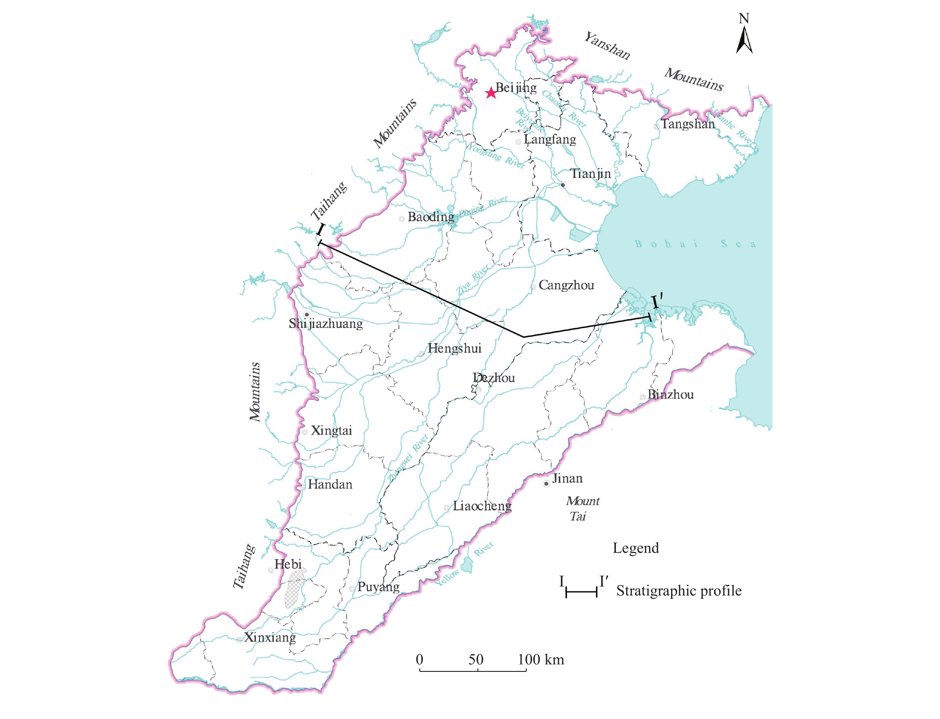
The North China Plain, with Taihang Mountains to the west, Yan Mountains to the north, Bohai Sea to the east and Yellow River to the south, incorporates all of the plains of Beijing, Tianjin and Hebei and those north of Yellow River in northern Henan and northern Shandong, covering an area of about 13.90×10⁴ km2 (Fig. 1) (Li et al. 2020; Zhang et al. 2011). The plain slopes down towards Bohai Bay from the west, north and south-west. The area falls in a continental semi-arid and semi-humid monsoon climate zone with the surface water system composed by Luanhe River in the north, Haihe River in the south, Tuhai River and Majia River.
The unsaturated zone in the Plain is dominated by the source area of Taihang-Yan Mountains. The unsaturated zone in the piedmont plain, constituted by alluvial and proluvial sediments such as gravel and medium-coarse sand with a thickness of 20–40 m, has high infiltration rate and storage, making it a favorable site for recharge. The unsaturated zone in the central-eastern plain consists of alluvial and lacustrine deposits such as medium-fine sand, silty clay, and clay, decreasing in thickness from 10–20 m to 3–5 m from west to east. The coastal plain is composed of marine deposits of clay, clay-silty sand and fine sand, and less than 3 m thick.
Groundwater in the North China Plain is featured by pore water in loose deposits and is divided into four aquifer groups from top to bottom. Depth to water table in Group Ⅰ is generally less than 50 m with rapid groundwater circulation. Depth to water level in Group Ⅱ is 120–210 m, which, as weakly-confined and semi-confined aquifer, is the main target layer for agricultural water exploitation in the piedmont plain. Depth to water level in Group Ⅲ is 250–310 m as a confined aquifer with slow circulation. It sustains the agricultural need of the central-eastern plain. Depth to water level is 350–550 m in Group Ⅳ, which is only exploited in some areas of the coastal plain concerning its much slower circulation. The shallow groundwater of the piedmont plain resides in Group Ⅰ and Ⅱ, and in Group Ⅰ when it comes to the central-eastern plain in the formation of saline water and saltwater. The deep groundwater exists in Group Ⅲ and Ⅳ in the predmont plain and in Group Ⅱ and Ⅲ in the central-eastern plain (Fig. 2) (Zhang et al. 2009). Ground infiltration is more suitable to recharge the shallow groundwater, and deep groundwater is normally recharged through wells.
Figure 2. Hydrogeological profile of the North China Plain (Zhang et al. 2009)2. Methodology
The study collects and analyses surface water monitoring data of the recharge section provided by water conservancy department. It uses the recharge volume in 2020 as the benchmark for optimizing recharge plan, and adopts the groundwater recharge infiltration rate calculated by previous researchers as the hydrogeological parameter for analysis, to comprehensively illustrate the restoration effect and quality improvement. The optimized plan is proposed to repair the depression zones, and the plan’s effect is also evaluated through the numerical model in GMS.
Groundwater level data are obtained from observation site 5752 which is designated in the Haihe River Basin Hydrogeological Survey Project in 2020 and site 2243 in the National Groundwater Monitoring Project. Firstly, the study presents the groundwater flow field under current conditions and maps depressions zones and its spatial distribution. Secondly, it calculates the required recharge amount on the basis of filling the groundwater deficit by 2035 as proposed in the Action Plan for the Management of Groundwater over-exploitation in North China, jointly issued by the Ministry of Water Resources and other ministries. Thirdly, it sets the target for groundwater level restoration in depression zones at a level consistent with the early 1980s when large-scale extraction in the Plain had not yet caused regional geological problems. Ultimately, an optimized plan is formulated.
The porosity in the loose deposits is used to increase recharge and improve efficiency or repair geological problems caused by over exploitation. That requires the aquifer medium be highly permeable to meet needs of water recharge, storage, transport and discharge (Lin, 1984). The pore space in alluvial and proluvial fans of the predmont plain is fully available to store the recharge water, laterally supply to depression zones and increase groundwater level to the designated target. The study compares groundwater levels under current conditions with those in the 1980s, calculates water level variation using the GIS spatial analysis function, evaluates storage capacity in target areas and groundwater deficits in the depression zones in conjunction with the hydrometric parameter zoning. The storage capacity of target areas and groundwater deficit in depressions zones are calculated as follows:
Qs=∑ni=1Fi×μi×Δhi×10−2 (1) Where: Qs represents the storage capacity of target areas and groundwater deficit in depression zones (108 m3);
Fi represents the area of the i-th calculated partition (target areas and depression zones);
μi represents the specific yield of the i-th calculated partition (target areas and depression zones);
Δhi represents the variation (m) in groundwater levels between current and early 1980s of the i-th calculated partition (target areas and depression zones);
3. Recharge to rivers
3.1 Recharge effectiveness
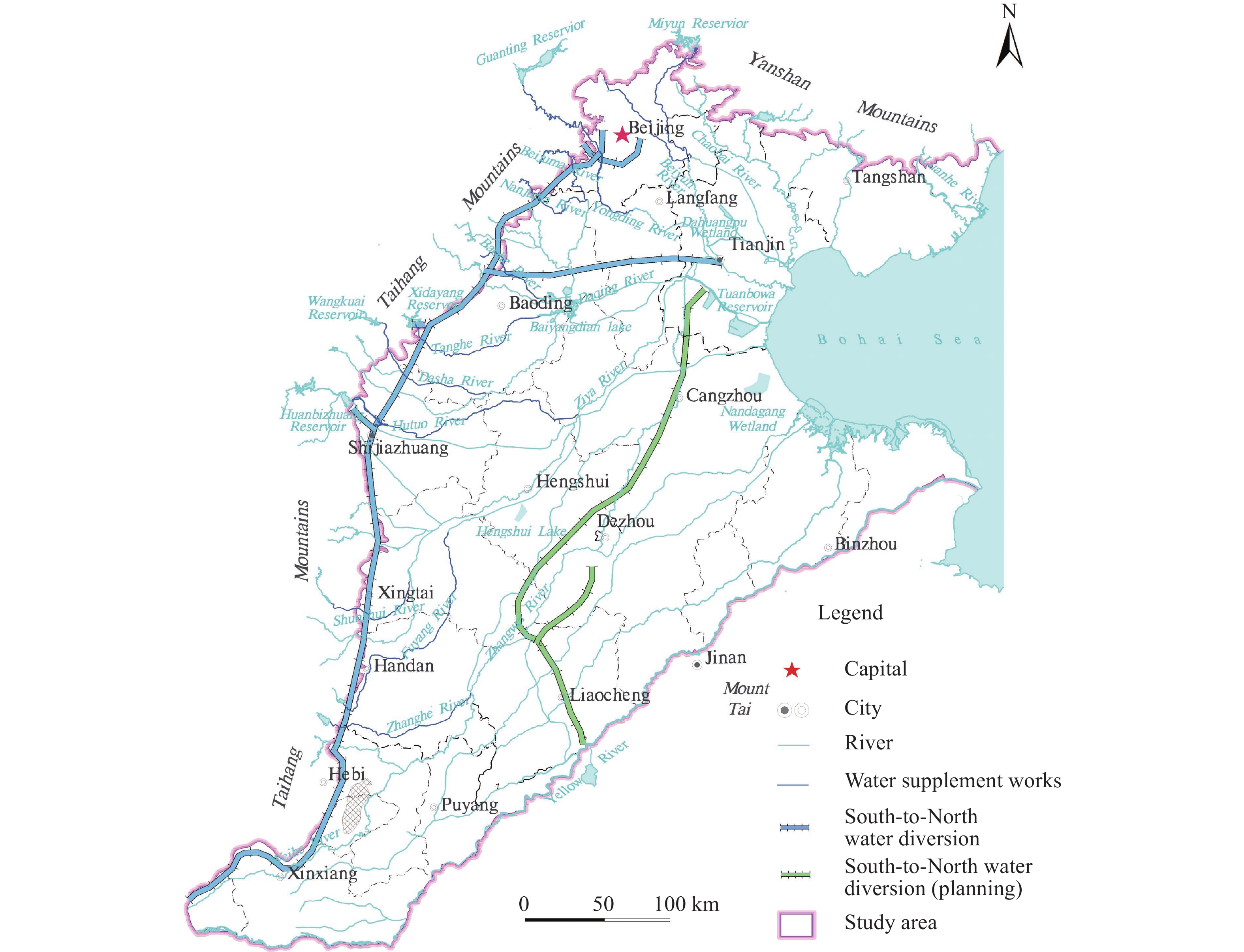
Since 2014, the South-to-North Water Diversion Project’s central route has been supplying water to alleviate over-exploitation in the North China Plain. In the next year, the project was joined by reservoirs such as Huairou Reservoir and Miyun Reservoir to utilize Chaobai River to carry out ecological water recharge through ground infiltration (He et al. 2019). From September 2018 to August 2019, the project launched a pilot project of river ecological recharge in Hutuo River, South Juma River and Fuyang River to replenish over 14.00×10⁸ m3 of water to the rivers. The practice was then extended to 15 rivers, including Chaobai River, North Canal, Yongding River, North Juma River-Baigou River, South Juma River, Tanghe River, Shahe River-Zhulong River, Baohe River, Hutuo River, Zhihe River, Qili River-Shunshui River, Fuyang River, Zhanghe River, Weihe River, South Canal in 2020. The replenishment amount of seven lakes—Baiyangdian, Qilihai Lake, Dahuangbaowa Lake, Beidagang Lake, Hengshui Lake, Tuanbowa Lake and Nandaigang Lake (Fig. 3)-increased to 44.20×10⁸ m3 (Chen et al. 2021). Researchers have conducted extensive research focusing on groundwater level restoration, quality improvement and remediation of geological problems after recharge.
(1) Groundwater level restoration
Researchers have evaluated river infiltration rates by monitoring the dynamic changes in groundwater levels after recharge and have come to the following conclusions: (1) Infiltration rates of river ecological recharge vary greatly due to differences in the lithological structure of unsaturated zones, which can exceed 40% in major rivers; (2) The groundwater level rebounds to varying degrees after recharge with a rate of 0.33–8.00 m/a on both sides of the river, but there is a significant lag in its rebound.
Since 2015, the water diversion project has collaborated with reservoirs such as Huairou Reservoir and Miyun Reservoir to implement ecological water recharge in Chaobai River with supply growing from 0.34×10⁸ m3 in 2015 to 2.93×10⁸ m3 in 2018. The infiltration rate reached 85.00%–98.70%. The groundwater level rose by an average of 6–8 m/a in December 2018 (He et al. 2019). From September 2018 to August 2019, the project, in conjunction with upstream reservoirs, rolled out a river ecological recharge pilot project on Hutuo River, South Juma River and Fuyang River, with the highest infiltration rate of 80% in Hutuo, followed by 57% in South Juma and the lowest 44% in Fuyang (Wang et al. 2021). The average rise in groundwater level within 10 km along rivers after recharge was 0.33 m, with the maximum on both sides of Hutuo River being 1.91 m (Wang et al. 2021; Yu and Qi, 2020). River infiltration rates reached 41%–58% in different river sections in 2019 under the recharge rate of 40 m3/s in Yongding River with a significant lag in water level rebound after recharge (Hu et al. 2020). In the following year, recharge was extended to 22 rivers and lakes, with groundwater level rising by an average of 1.47 m within 5 km on both sides of 11 rivers including the three typical rivers, affecting an area of 1.62×10⁴ km2, and the results were successful (Yang et al. 2022).
(2) Water quality improvement
Studies on water quality changes after recharge have shown that: Recharge is supported by diverted water from the project’s central route, and conducted through ground infiltration, from which the dilution effect helped to improve groundwater quality and reduce total hardness and total dissolved solids.
According to results based on the solute transport model, the regular indices of the Danjiangkou (reservoir) source area was lower than that of Mihuaisun source area, indicating its dominant role of dilution in the process of recharge and further improving groundwater quality (Liu et al. 2015; Zheng et al. 2012). Dissolution of calcite, dolomite, potash feldspar, rock salt and CO2 and Mg/Ca-Na cation exchange reactions occurred in the groundwater after recharge (Jia et al. 2016). Groundwater quality monitoring data demonstrated that when groundwater has been recharged through diverted water, all the processes of physical dilution, filtration of unsaturated zones, cation exchange adsorption and mineral precipitation have followed afterwards. Therefore, the total hardness and total dissolved solids of groundwater in Chaobai River recharge area decreased, and water quality improved (Xiao et al. 2017). Nitrification reaction led to, firstly, an increase and then a decrease in ammonia nitrogen concentration in the Mihuaisun recharge area (Huo et al. 2020). Cation exchange and adsorption caused a significant surge in HCO3−, Ca2+, Mg2+ and NO3− concentrations in Baiyangdian recharge area, enabling an evolution of the hydrochemical type from Na-HCO3 to Ca·Mg-HCO3 (Cui et al. 2021). The study proved that quality in 21% and 36% of monitoring wells in Hutuo River and South Juma River improved after recharge, with decreased chloride, TDS and total hardness in Hutuo River (Wang et al. 2021; Tian et al. 2021). The deterioration of quality found in 8% of the monitoring wells in Fuyang River (Wang et al. 2021) was presumed to be related to a localised potential source of pollution in the riverbed unsaturated zone.
3.2 Problems
Since 2015, the ecological recharge of rivers and lakes has been gradually extended to 22 rivers and lakes, and now covers the main rivers and lakes of the North China Plain. Groundwater recharge, however, mainly targets refined river ecological recharge and does not yet fully concentrate on repair needs of depression zones. The spatial distribution of recharge still needs further optimization. It is recommended to scale up the recharge of upstream alluvial and proluvial fans of main depression zones and optimize the ecological recharge plan to efficiently repair the depression and ensure the security of regional water supply. After recharge, groundwater monitoring for both water level and quality should be more frequent. Risk assessment also should be put into operation to ensure safety.
4. Preferred solution
4.1 Analysis of restoration targets and suitability of target areas
(1) Repair of shallow groundwater depression zones
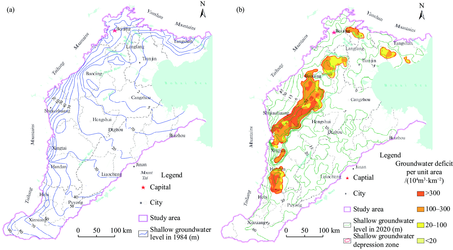
In the mid-1970s’, prolonged droughts induced widespread drilling of wells to ensure agricultural production in North China Plain. After the 1980s, along with rapid socio-economic development, large-scale exploitation of groundwater in agricultural areas caused a continuous water level decline, resulting in massive shallow groundwater depression zones in predmont plains. Since 2014, as the South-to-North Water Diversion Project’s central route has been charted to the integrated management of water supply and over-exploitation, water level in the main urban areas stopped dropping and has rebounded in spite of continuous decline in agricultural areas. According to observation data, by 2020, Gaoliqing-Ningbailong depression zone, Xiongxian-Bazhou depression zone, Handan Feixiang-Guangping depression zone, Pingxiang-Quzhou depression zone, Langfang Sanhe Depression Zone, Tanghai depression zone, and Luannan-Leting depression zone, in the front edge of alluvial and proluvial fans in predmont plains reached a total area of 1.58×10⁴ km2 (Table 1). Among these, Gaoliqing-Ningbailong depression zone, covers 0.96×10⁴ km2, which has been seriously threatening the safety of water supply in the agricultural area due to the water level depth of 103.19 m at the depression centre and the dewatering of the local aquifer. It is therefore urgent to repair these depression zones, optimize the recharge plan, gradually restore the water level and guarantee the supply security.
Table 1. Situation of shallow groundwater depression zones in the North China Plain in 2020Depression zones Size/104 km2 Depth of the zone centre/m Gaoliqing-Ningbailong depression zone 9 636.60 103.19 Xiongxian-Bazhou depression zone 1 989.14 62.82 Handan Feixiang-Guangping depression zone 2 035.54 79.75 Pingxiang-Quzhou depression zone 356.82 53.52 Langfang Sanhe depression zone 873.63 38.51 Tanghai depression zone 823.12 30.49 Luannan-Leting depression zone 149.28 14.21 (2) Groundwater level restoration targets
The target is to restore the groundwater level of depression zones to that in the 1980s (Fig. 4a). The evaluation has shown that all the groundwater level restoration targets in the depression zones are above the elevation of 0m, main areas of which faces an accumulated water deficit exceeding 20×104 m3/km2, with a total deficit of 317.25×10⁸ m3 in the depression zones in the North China Plain (Table 2). Among these, the target for Gaoliqing-Ningbailong Depression Zone is 5–30 m in which the cumulative deficit in the main area is more than 100×104 m3/km2, and more than 300×104 m3/km2 in the central section (Fig. 4b) with a total deficit of 227.99×10⁸ m3. The target for Handan Feixiang-Guangping depression zone is 42–60 m in which the cumulative deficit in the main areas is more than 100×104 m3/km2. Additionally, the deficit of the western and southern sections exceeds 300×104 m3/km2, and the whole area totals 46.55×10⁸ m3.
Table 2. Deficit in shallow groundwater depression zonesDepression zones Groundwater level in 2020/m Restoration targets/m Deficit/108 m3 Gaoliqing-Ningbailong depression zone −55–−10 5–30 227.99 Xiongxian-Bazhou depression zone −30–−5 1–10 19.52 Handan Feixiang-Guangping depression zone −30–20 42–60 46.55 Pingxiang-Quzhou depression zone −15–0 25–30 9.45 Langfang Sanhe depression zone −10–0 4–25 7.84 Tanghai depression zone −10–−25 0–4 4.93 Luannan-Leting depression zone −10–−5 0–2 0.97 Total 317.25 (3) Priority target areas for recharge and regulation space assessment
The evaluation of priority target areas for recharge has some major considerations: ① Sufficient water supply; ② High infiltration to ensure recharge efficiency; ③ Great depth of groundwater level to make sure ample space for storage; ④ Located in depression recharge zone so that the groundwater can be recharged laterally to reinstate its water level.
Based on those factors, seven priority recharge target areas are selected: Luanhe River Alluvial-proluvial fan, Chaobai-Jiyun River Alluvial-proluvial fan, Yongding River Alluvial-proluvial fan, Juma River Alluvial-proluvial fan, Hutuo-Dasha River Alluvial-proluvial fan, Fuyang River Alluvial-proluvial fan, Zhanghe River Alluvial-proluvial fan (Fig. 5). Target areas are all close to recharge sources such as the South-to-North Water Diversion Project’s central route and Shanqian Reservoir. The specific location of the target area allows for lateral recharge to the depression zone to be driven by groundwater gradient after raising the shallow groundwater level in alluvial and proluvial fans. The unsaturated zones in alluvial and proluvial fan consists of coarse granular material such as gravel and medium-coarse sand, which endows high infiltration. The depth to groundwater level of 6–57 m and the ample space for storage make those target areas ideal for shallow groundwater recharge. The storage capacity is calculated to be 181.00×10⁸ m3, taking the groundwater level in the early 1980s as the standard for the calculation (Table 3).
Table 3. Regulation space for recharge priority target areas in the North China PlainRecharge priority target areas Size/km2 Buried depth/m Regulation space/108 m3 Luanhe River Alluvial-proluvial fan 2 728.78 6–30 8.30 Chaobai-Jiyun River Alluvial-proluvial fan 2 107.90 8–35 13.90 Yongding River Alluvial-proluvial fan 2 543.99 15–30 16.30 Juma River Alluvial-proluvial fan 927.36 12–28 7.90 Hutuo-Dasha River Alluvial-proluvial fan 6 456.71 18–57 118.90 Fuyang River Alluvial-proluvial fan 923.51 8–41 4.80 Zhanghe River Alluvial-proluvial fan 1 025.06 12–48 10.90 Total 16 713.31 181.00 Target areas of Luanhe River Alluvial-proluvial Fan are set up to restore the water level of Tanghai depression zone, and Luannan-Leting depression zone, in Chaobai-Jiyun River Alluvial-proluvial fan to restore Langfang Sanhe depression zone, in Yongding River Alluvial-proluvial fan and Juma River Alluvial-proluvial fan to restore Xiongxian-Bazhou depression zone, in Hutuo-Dasha River Alluvial-proluvial fan to restore Gaoliqing-Ningbailong depression zone, in Fuyang River Alluvial-proluvial fan to restore Pingxiang-Quzhou depression zone, and in Zhanghe River Alluvial-proluvial fan to restore Handan Feixiang-Guangping depression zone.
4.2 Analysis of recharge plan and effectiveness
(1) Optimized plan
Seven target areas are selected, such as Luanhe River Alluvial-proluvial Fan, Chaobai-Jiyun River Alluvial-proluvial Fan, Yongding River Alluvial-proluvial Fan, Juma River Alluvial-proluvial Fan, Hutuo-Dasha River Alluvial-proluvial Fan, Fuyang River Alluvial-proluvial Fan, Zhanghe River Alluvial-proluvial Fan to repair depression zones through recharge. The water supply is supported by the South-to-North Water Diversion Project’s central route in conjunction with Panjikou Reservoir, Miyun Reservoir, Wangkuai Reservoir, Huangbizhuang Reservoir, Zhuzhuang Reservoir, Yuecheng Reservoir, and others. The recharge water is diverted to Luanhe River, Chaobai River, Yongding River, South Juma River, Hutuo River, Dasha River, Tanghe River, Qili River-Shunshui River, Zhanghe River, Anyang River. The infiltration rate could refer to relevant studies. With a total demand for recharge of 466.60×10⁸ m3 and the target to fill the deficit in the shallow groundwater depression zone by 2035, recharge amount has to be 31.18×10⁸ m3 annually.
After comparison between water demand required by recharge and water recharged in 2020, the optimized plan integrates factors of target areas and water source and the target level restoration by 2035. It is based on on a previous plan in 2020. It includes: (1) With the standard of 11.43×10⁸ m3, the amount of 7.57×10⁸ m3/a needs to be recharged to Hutuo River, Dasha River, Tanghe River to repair Gaoliqing-Ningbailong depression zone; (2) With the standard of 3.19×10⁸ m3 in Fuyang River and Zhanghe River, the amount of 3.86×10⁸ m3/a needs to be recharged to the two rivers, together with Anyang River, to repair Handan Feixiang-Guangping depression zone; (3) The amount of 0.56×10⁸ m3/a needs to be recharged to Luanhe River to repair Tanghai depression zone and Luannan-Leting depression zone; the recharge to North Grand Canal and Yongding River can be moderately decreased to prevent excessive water level rebound which will threaten the safe use of urban underground space in Beijing and pose the potential risk of soil salinization (Table 4).
Table 4. Optimized Plan for Groundwater Recharge in the North China PlainRecharge
target areasDepression zone repair Recharge source Recharge river Deficit
/108 m3Recharge infiltration rate Repair water requirements
/108 m3Optimized plan
/108 m3/aTo be optimised plan—
recharge volume in 2020
/108 m3/aLuanhe River alluvial-proluvial fan
Tanghai depression Zone, Luannan-Leting depression zone
Luanhe River Source, Panjikou Reservoir, Daheiting Reservoir, Taolinkou Reservoir
Luanhe River 5.90 0.70 7.38 0.56 / Chaobai-Jiyun River alluvial-proluvial fan
Langfang Sanhe depression zone
Source of South-to-North Water Diversion Project’s Central Route, Miyun Reservoir, Huairou Reservoir
Chaobai River, North Canal
7.84 0.85 9.22 0.61 7.56 Yongding River alluvial-proluvial fan
Xiongxian-Bazhou depression zone
Source of South-to-North Water Diversion Project’s Central Route, Guanting Reservoir
Yongding River, North Juma River-Baigou River
19.52 0.495 26.56 1.77 3.46 Juma River alluvial-proluvial fan
Source of South-to-North Water Diversion Project’s Central Route, Angezhuang Reservoir
South Juma River
0.57 11.18 0.75 0.88 Hutuo-Dasha River alluvial-proluvial fan
Gaoliqing-Ningbailong depression zone
Source of South-to-North Water Diversion Project’s Central Route, Huangbizhuang Reservoir, Wangkuai Reservoir, Xidayang Reservoir
Hutuo River, Dasha River, Tanghe River
227.99 0.80 284.99 19.00 11.43 Fuyang River alluvial-proluvial fan
Pingxiang-Quzhou depression zone
Source of South-to-North Water Diversion Project’s Central Route, Zhuzhuang Reservoir
Qili River-Shunshui River
9.45 0.44 21.48 1.43 2.06 Zhanghe River alluvial-proluvial fan
Handan Feixiang-Guangping depression zone
Source of South-to-North Water Diversion Project’s Central Route, Yuecheng Reservoir, Dongwushi Reservoir
Fuyang River,Zhanghe River, Anyang River
46.55 0.44 105.80 7.05 3.19 Total 317.25 317.25 466.60 31.18 (2) Effectiveness
The water level restoration in shallow groundwater depression zone is verified through numerical models by GMS software with the assumption of 50% precipitation possibility and under current exploitation conditions, and the recharge optimized plan is incorporated into the model. Model result shows that as groundwater recharge is carried out, the water level in zones will rebound each year and restore to the target level by 2035 (Fig. 6). The water level restoration can not only improve the quality of groundwater resources and geological environment, but also enhance the water supply capacity in agriculture and food security.
5. Recommendation and conclusions
The Ministry of Water Resources has implemented a series of artificial groundwater recharge projects in the North China Plain and the results have been successful. The recharge plan, however, has not yet fully focused on repair of shallow groundwater depression zone and still needs further optimization.
The paper proposes an optimized plan and recharge recommendations with the objective of filling the deficit in depression zones by 2035. The details are as follows:
(1) Highlight the repair demand and select 7 target areas of Luanhe River Alluvial-proluvial Fan, Chaobai-Jiyun River Alluvial-proluvial Fan, Yongding River Alluvial-proluvial Fan, Juma River Alluvial-proluvial Fan, Hutuo-Dasha River Alluvial-proluvial Fan, Fuyang River Alluvial-proluvial Fan, and Zhanghe River Alluvial-proluvial Fan, with an estimated storage capacity of 181.00×10⁸ m3;
(2) Set the target of water level restoration by 2035. The annual recharge volume is estimated to be 31.18×10⁸ m3 by evaluating the accumulative groundwater deficit of 317.25×10⁸ m3 and the recharge demand of 466.60×10⁸ m3 based on the infiltration rate;
(3) By 2035, increase the recharge amount to 19.00×10⁸ m3/a in Hutuo River, Dasha River, Tanghe River to repair Gaoliqing-Ningbailong Depression Zone; 7.05×10⁸ m3/a in Fuyang River, Zhanghe River and Anyang River to repair Handan Feixiang-Guangping Depression Zone; 0.56×10⁸ m3/a in Luanhe River to repair Tanghai Depression Zone and Luannan-Leting Depression Zone; moderately decrease the recharge to North Canal and Yongding River to prevent excessive water level rebound;
(4) Pilot recharge project through wells in areas of severe urban ground subsidence and coastal seawater intrusion to prevent the risk of deteriorating geological problems due to continued groundwater level decline;
(5) Groundwater quality monitoring strategy should be modified and refined in recharge areas and an early warning mechanism for quality risks should be established to ensure safety.
Acknowledgements
This work was funded by Geological Joint Fund of the National Natural Science Foundation of China (U2244214), China Geological Survey Program (DD20190336, DD20221752, DD20230078), Chinese Academy of Geological Sciences Basic Research Fund Program (SK202118, SK202216), and Hebei Provincial Innovation Capacity Enhancement Program for High-level Talent Team Building (225A4204D).
-
Table 1. Situation of shallow groundwater depression zones in the North China Plain in 2020
Depression zones Size/104 km2 Depth of the zone centre/m Gaoliqing-Ningbailong depression zone 9 636.60 103.19 Xiongxian-Bazhou depression zone 1 989.14 62.82 Handan Feixiang-Guangping depression zone 2 035.54 79.75 Pingxiang-Quzhou depression zone 356.82 53.52 Langfang Sanhe depression zone 873.63 38.51 Tanghai depression zone 823.12 30.49 Luannan-Leting depression zone 149.28 14.21 Table 2. Deficit in shallow groundwater depression zones
Depression zones Groundwater level in 2020/m Restoration targets/m Deficit/108 m3 Gaoliqing-Ningbailong depression zone −55–−10 5–30 227.99 Xiongxian-Bazhou depression zone −30–−5 1–10 19.52 Handan Feixiang-Guangping depression zone −30–20 42–60 46.55 Pingxiang-Quzhou depression zone −15–0 25–30 9.45 Langfang Sanhe depression zone −10–0 4–25 7.84 Tanghai depression zone −10–−25 0–4 4.93 Luannan-Leting depression zone −10–−5 0–2 0.97 Total 317.25 Table 3. Regulation space for recharge priority target areas in the North China Plain
Recharge priority target areas Size/km2 Buried depth/m Regulation space/108 m3 Luanhe River Alluvial-proluvial fan 2 728.78 6–30 8.30 Chaobai-Jiyun River Alluvial-proluvial fan 2 107.90 8–35 13.90 Yongding River Alluvial-proluvial fan 2 543.99 15–30 16.30 Juma River Alluvial-proluvial fan 927.36 12–28 7.90 Hutuo-Dasha River Alluvial-proluvial fan 6 456.71 18–57 118.90 Fuyang River Alluvial-proluvial fan 923.51 8–41 4.80 Zhanghe River Alluvial-proluvial fan 1 025.06 12–48 10.90 Total 16 713.31 181.00 Table 4. Optimized Plan for Groundwater Recharge in the North China Plain
Recharge
target areasDepression zone repair Recharge source Recharge river Deficit
/108 m3Recharge infiltration rate Repair water requirements
/108 m3Optimized plan
/108 m3/aTo be optimised plan—
recharge volume in 2020
/108 m3/aLuanhe River alluvial-proluvial fan
Tanghai depression Zone, Luannan-Leting depression zone
Luanhe River Source, Panjikou Reservoir, Daheiting Reservoir, Taolinkou Reservoir
Luanhe River 5.90 0.70 7.38 0.56 / Chaobai-Jiyun River alluvial-proluvial fan
Langfang Sanhe depression zone
Source of South-to-North Water Diversion Project’s Central Route, Miyun Reservoir, Huairou Reservoir
Chaobai River, North Canal
7.84 0.85 9.22 0.61 7.56 Yongding River alluvial-proluvial fan
Xiongxian-Bazhou depression zone
Source of South-to-North Water Diversion Project’s Central Route, Guanting Reservoir
Yongding River, North Juma River-Baigou River
19.52 0.495 26.56 1.77 3.46 Juma River alluvial-proluvial fan
Source of South-to-North Water Diversion Project’s Central Route, Angezhuang Reservoir
South Juma River
0.57 11.18 0.75 0.88 Hutuo-Dasha River alluvial-proluvial fan
Gaoliqing-Ningbailong depression zone
Source of South-to-North Water Diversion Project’s Central Route, Huangbizhuang Reservoir, Wangkuai Reservoir, Xidayang Reservoir
Hutuo River, Dasha River, Tanghe River
227.99 0.80 284.99 19.00 11.43 Fuyang River alluvial-proluvial fan
Pingxiang-Quzhou depression zone
Source of South-to-North Water Diversion Project’s Central Route, Zhuzhuang Reservoir
Qili River-Shunshui River
9.45 0.44 21.48 1.43 2.06 Zhanghe River alluvial-proluvial fan
Handan Feixiang-Guangping depression zone
Source of South-to-North Water Diversion Project’s Central Route, Yuecheng Reservoir, Dongwushi Reservoir
Fuyang River,Zhanghe River, Anyang River
46.55 0.44 105.80 7.05 3.19 Total 317.25 317.25 466.60 31.18 -
Auckenthaler A, Baenninger D, Zechner E, et al. 2010. Drinking water production close to contaminant sites: A case study from the region of Basel, Switzerland. IAHS Publication, 342: 167−170.
Azizur RM, Rernd R, Gogu RC, et al. 2012. A new spatial multi-criteria decision support tool for site selection for implementation of managed aquifer recharge. Journal of Environmental Management, 99: 61−75. DOI:10.1016/j.jenvman.2012.01.003.
Bouwer H. 2002. Artificial recharge of groundwater: Hydrogeology and engineering. Hydrogeology Journal, 10: 121−142. DOI:10.1007/s10040-001-0182-4.
Chen F, Ding YY, Tang SN, et al. 2021. Practice and effect analysis of river-lake ecological water supplement and groundwater recharge in the North China region. China Water Resources, 07: 36−39. (in Chinese)
Cui X, Zhang B, He MX, et al. 2021. Impacts of ecological water replenishment on the hydrochemical characteristics of surface water and groundwater in Lake Baiyangdian Watershed. Journal of Lake Sciences, 33(06): 1675−1686. (in Chinese) DOI:10.18307/2021.0606.
Dillon PJ. 2004. Future management of aquifer recharge. Hydrogeology Journal, 13(1): 313−316. DOI:10.1007/s10040-004-0413-6.
Ghayoumian J, Ghermezcheshme B, Feizinia S, et al. 2005. Integrating GIS and DSS for identification of suitable for artificial recharge, case study Meimeh Basin, Isfahan, Iran. Environmental Geology, 47: 493−500. DOI:10.1007/s00254-004-1169-y.
He YP, Li SJ, Li Y, et al. 2019. Effect of South-to-North water transfer project on recharge and water level in Chaobai river area. Beijing Water, 03: 21−26. (in Chinese) DOI:10.19671/j.1673-4637.2019.03.006.
Hendricks FHJ, Kaiser HP, Kuhlmann U, et al. 2011. Operational real-time modeling with ensemble Kalman filter of variably saturated subsurface flow including stream-aquifer interaction and parameter updating. Water Resources Research, 47 (2): W02532.
Hu LT, Guo JL, Zhang SQ, et al. 2020. Response of groundwater regime to ecological water replenishment of the Yongding River. Hydrogeology & Engineering Geology, 47(05): 5−11. (in Chinese) DOI:10.16030/j.cnki.issn.1000-3665.202008027.
Huo LT, Wang BX, Pan ZH, et al. 2020. Environmental impact by surface-water recharge of groundwater in Beijing Mihuaishun replenishment area-correspondence analysis. Journal of Beijing Normal University (Natural Science), 56(02): 195−203. (in Chinese) DOI:10.12202/j.0476-0301.2020058.
Jia WF, Yang Y, Zhao Y, et al. 2016. Simulation of the water-rock reaction in Chaobai River ground-water storage area. South-to-North Water Transfers and Water Science & Technology, 14(01): 143−148, 135. (in Chinese) DOI:10.13476/j.cnki.nsbdqk.2016.01.024.
Li HT, Shi P, Wu HX. 2008. Artificial recharge technology of groundwater. Natural Resource Economics of China, (03): 41−42, 45, 48. (in Chinese)
Li WP, Wang LF, Yang HF, et al. 2020. The groundwater over-exploitation status and countermeasure suggestions of the North China Plain. China Water Resources, 13: 26−30. (in Chinese)
Lin XY. 1984. On development and utilization of groundwater reservoir. Journal of Jilin University (Earth Science Edition), 02: 113−121. (in Chinese)
Liu LC, Zheng FD, Li BH, et al. 2015. Experiment of groundwater quality change for simulating the South-to-North water into the Mihuaishun aquifer. Hydrogeology & Engineering Geology, 42(04): 18−22, 55. (in Chinese) DOI:10.16030/j.cnki.issn.1000-3665.2015.04.04.
Moeck C, Radny D, Borer P, et al. 2016. Multicomponent statistical analysis to identify flow and transport processes in a highly-complex environment. Journal of Hydrology, 542: 437−449. DOI:10.1016/j.jhydrol.2016.09.023.
Sarfaraz A, Annesh B, Sujith R, et al. 2021. Managed aquifer recharge implementation criteria to achieve water sustainability. Science of the Total Environment, 768: 1−19. DOI:10.1016/J.SCITOTENV.2021.144992.
Shi JS, Li GM, Liang X, et al. 2014. Evolution mechanism and control of groundwater in the North China Plain. Acta Geoscientica Sinica, 35(5): 527−534. (in Chinese) DOI:10.3975/cagsb.2014.05.01.
Sprenger C, Hartog N, Hernández M, et al. 2017. Inventory of managed aquifer recharge sites in Europe: Historical development, current situation and perspectives. Hydrogeology Journal, 25: 1909−1922. DOI:10.1007/s10040-017-1554-8.
Tian MZ, Zhao L, Cui WJ, et al. 2022. Control and influence of rising groundwater level on land under the background of South-to-North Water Diversion: A case study of Chaobai River groundwater system in Beijing. Geology in China. (in Chinese)
Tian X, Meng SH, Cui XX, et al. 2021. Hydrochemical Effect of groundwater recharge in over-exploited area of Hutuo River Basin. Research of Environmental Sciences, 34(03): 629−636. (in Chinese) DOI:10.13198/j.issn.1001-6929.2020.07.19.
Wang Z, Fu Y, Zhu JS, et al. 2021. Effect assessment on groundwater recharge for typical rivers in North China. Journal of Jilin University (Earth Science Edition), 51(03): 843−853. (in Chinese) DOI:10.13278/j.cnki.jjuese.20200078.
Xiao Y, Shan R, Li S, et al. 2017. Change in groundwater resource and environment of South-to-North water recharge area of Chaobai River. Beijing Water, (04): 5−8. (in Chinese) DOI:10.19671/j.1673-4637.2017.04.002.
Yang HF, Cao WG, Zhi CS, et al. 2021. Evolution of groundwater level in the North China Plain in the past 40 years and suggestions on its overexploitation treatment. Geology in China, 48(04): 1142−1155. (in Chinese) DOI:10.12029/gc20210411.
Yang HF, Meng RF, Bao XL, et al. 2022. Assessment of water level threshold for groundwater restoration and over-exploitation remediation the Beijing-Tianjin-Hebei Plain. Journal of Groundwater Science and Engineering, 10(02): 113−127.
Yu Y, Qi TL. 2020. Analysis on the effect of comprehensive control pilot project of groundwater supplement for groundwater over-abstraction in Northern China. Haihe Water Resources, (03): 7−9,16. (in Chinese) DOI:10.3969/j.issn.1004-7328.2020.03.003.
Zhang GH, Fei YH, Liu KY, et al. 2007. Groundwater potential recovery and water level variation in the Shijiazhuang water-receiving area at the central line of the south-to-north water transfer project. Geological Bulletin of China, 144(05): 583−589. (in Chinese)
Zhang GH, Lian YL, Liu CH, et al. 2011. Situation and origin of water resources in short supply in North China Plain. Journal of Earth Sciences and Environment, 33(2): 172−176. (in Chinese)
Zhang ZJ, Fei YH, Chen ZY, et al. 2009. Investigation and Evaluation of Sustainable Utilization of Groundwater in North China Plain. Beijing: Geological publishing house. (in Chinese)
Zheng FD, Liu LC, Yang MQ, et al. 2012. Simulation of water-rock interaction in the injection of water from the South-to-North Diversion Project to the aquifer in the western suburb of Beijing. Hydrogeology & Engineering Geology, 39(06): 22−28. (in Chinese) DOI:10.16030/j.cnki.issn.1000-3665.2012.06.005.
Zhu JY, Guo HP, Li WP, et al. 2014. Relationship between land subsidence and deep groundwater yield in the North China Plain. South-to-North Water Transfers and Water Science & Technology, 12(3): 165−169. (in Chinese) DOI:10.13476/j.cnki.nsbdqk.2014.03.036.
-