

-
摘要:
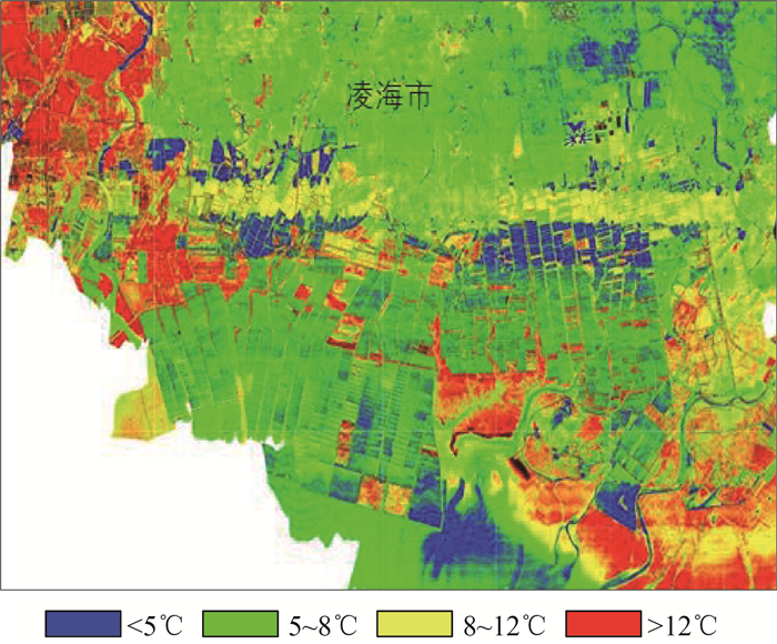
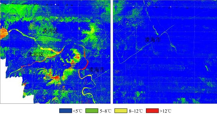
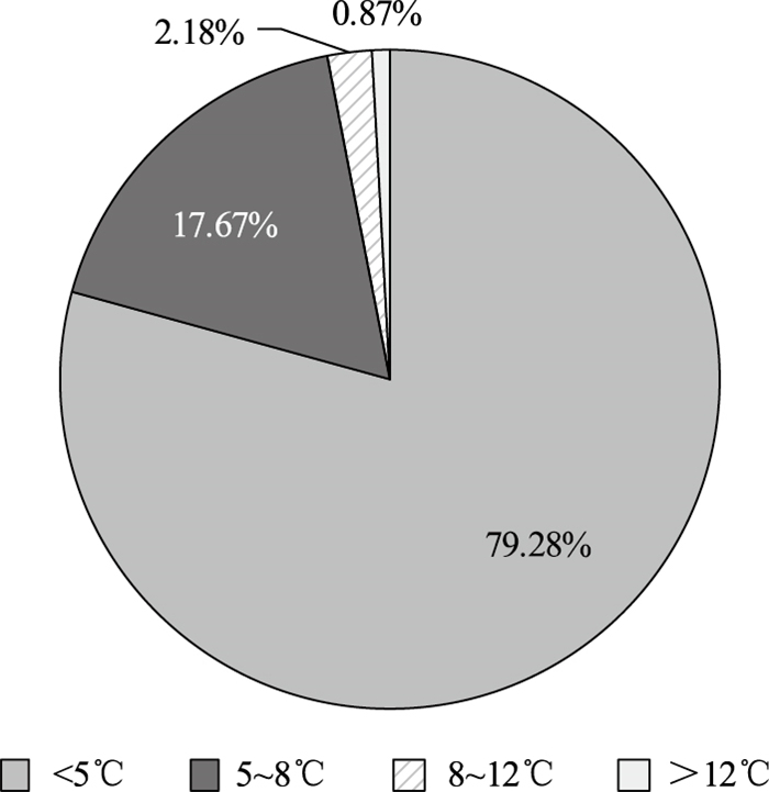
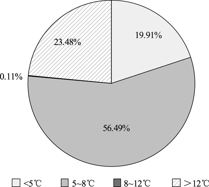
基于航空热红外高光谱TASI数据开展城市热岛强度研究,通过建立热红外高光谱发射率的经验关系,对分离方法(TES)中MMD模块予以改进,建立针对TASI数据的温度反演模型,利用该模型完成了1500 km2锦州市TASI数据处理和温度反演工作,开展城市热岛的空间分布、范围及强度研究。结果表明,TASI数据反演温度与实测温度的平均绝对误差为0.81 K,平均相对误差为0.25%,提取的城市热异常范围准确,能够为城市热岛研究提供一定的决策支持;城市热岛强度与不透水面呈正相关关系,与植被覆盖呈负相关关系;城市热岛强度与土地利用覆盖类型有较大相关性,现代居民区和商业区强度高于城中村和城乡结合部建筑,农用地城市热岛强度最低。
Abstract:The research on the urban heat island effect based on aerial thermal infrared hyperspectral TASI data was conducted. By establishing the empirical relationship of thermal infrared hyperspectral emissivity, the MMD module in the separation method (TES) was improved, and a temperature inversion model for TASI data was established.Using this model, TASI data processing and temperature inversion in the 1500 km2 area of Jinzhou City were completed, and the spatial distribution, range and intensity of urban heat islands were studied.The results show that the average absolute error between the inversion temperature and the measured temperature of the TASI data is 0.81 K, and the average relative error is 0.25%. The extracted range of urban thermal anomalies is accurate, which can provide certain decision support for the research of urban heat islands. The intensity of urban heat islands shows a positive correlation with the permeable surface and a negative correlation with the vegetation cover.It has a greater correlation with the type of used land cover. The urban heat island intensity of modern residential and commercial areas is higher than that of urban villages and rural-urban fringe buildings, and the urban heat island intensity of agricultural land is the lowest.
-

-
表 1 温度反演结果与实测结果比较
Table 1. Comparison of temperature inversion results and measured results
点号 实测温度/℃ 反演温度/℃ 反演误差/℃ 相对误差 地物类型 1-1 4.3 3.8 0.5 0.15% 砂石地 1-2 4.4 5.1 0.7 0.21% 草甸地 2-1 1.1 1.9 0.8 0.25% 水泥广场 2-2 4.6 5.4 0.8 0.24% 植被 3-1 2.4 2.9 0.5 0.15% 裸土 3-2 3.4 5.1 1.7 0.52% 玉米地秸秆 4-1 1.7 2.4 0.7 0.21% 砂石地 4-2 2.9 3.1 0.2 0.06% 草地 5-1 4.2 3.8 0.4 0.12% 大豆地 6-1 6.7 5.8 0.9 0.27% 水泥地 7-1 3.4 2.9 0.4 0.12% 裸土 8-1 3.1 4.0 0.9 0.27% 裸土 10-1 4.2 3.0 1.2 0.36% 大豆地裸土 11-1 2.1 1.9 0.2 0.06% 主干道柏油路 11-2 2.6 2.9 0.3 0.09% 玉米地裸土 11-3 6.3 6.2 0.1 0.03% 主干道柏油路 12-1 2.4 2.1 0.3 0.09% 大豆地裸土 14-1 8.3 9.5 1.2 0.36% 主干道柏油路 14-2 3.8 4.1 0.3 0.09% 养殖场水体 15-2 6.1 9.3 3.2 0.97% 主道旁土壤 16-1 6.9 9.2 2.3 0.69% 滩涂 均差 0.81 0.25%  下载: 导出CSV
-
[1] 杨敏, 杨贵军, 王艳杰, 等. 北京城市热岛效应时空变化遥感分析[J]. 国土资源遥感, 2018, 30(3): 213-223. https://www.cnki.com.cn/Article/CJFDTOTAL-GTYG201803029.htm
[2] Gau RA, Eichenbaum M K, Simonovic S P. Analysis and modelling of surface Urban Heat Island in 20 Canadian cities under climate and land-cover change[J]. Journal of Environmental Management, 2018, 206: 145-157.
[3] 谢敏, 孙明, 蔡建初, 等. 滨海城市化地区热岛效应的遥感分析研究: 以防城港为例[J]. 气象研究与应用, 2018, 39(3): 66-71. doi: 10.3969/j.issn.1673-8411.2018.03.017
[4] 佟光臣, 林杰, 陈杭, 等. 基于多时相遥感数据的常州市城市热景观变化特征[J]. 水土保持研究, 2017, 24(1): 207-212. https://www.cnki.com.cn/Article/CJFDTOTAL-STBY201701035.htm
[5] 王刚, 张秋平, 肖荣波, 等. 秋冬季节广州城市绿地对热岛效应的调控作用差异分析[J]. 中山大学学报(自然科学版), 2018, 57(5): 38-48. https://www.cnki.com.cn/Article/CJFDTOTAL-ZSDZ201805005.htm
[6] 程志刚, 李炬, 周明煜, 等. 北京中央商务区(CBD) 城市热岛效应的研究[J]. 气候与环境研究, 2018, 23(6): 633-644. https://www.cnki.com.cn/Article/CJFDTOTAL-QHYH201806001.htm
[7] 李学敏, 文力, 王俪璇. 基于Landsat遥感数据的城市热岛效应及影响因素-以襄阳市为例[J]. 湖北农业科学, 2019, 58(16): 41-48. https://www.cnki.com.cn/Article/CJFDTOTAL-HBNY201916011.htm
[8] 夏天, 黎璇, 何东进, 等. 福建平潭岛填海活动热岛效应的时空变异[J]. 森林与环境学报, 2019, 39(5): 540-547 https://www.cnki.com.cn/Article/CJFDTOTAL-FJLB201905013.htm
[9] 吴泽群, 田淑芳. 基于TASI发射率数据的层状硅酸盐蚀变矿物提取识别[J]. 国土资源信息化, 2015, (2): 32-37. doi: 10.3969/j.issn.1674-3695.2015.02.007
[10] 高海东, 胡宝群, 吕古贤, 等. 山东玲珑金矿50号脉三维构造蚀变岩地球化学特征及深部预测[J]. 地质通报, 2020, 39(11): 1793-1806. http://dzhtb.cgs.cn/gbc/ch/reader/view_abstract.aspx?file_no=20201111&flag=1
[11] 李娜, 董新丰, 甘甫平, 等. 高光谱遥感技术在基岩区区域地质调查填图中的应用[J]. 地质通报, 2021, 40(1): 13-21. http://dzhtb.cgs.cn/gbc/ch/reader/view_abstract.aspx?file_no=20210102&flag=1
[12] 牛海威, 李名松, 汪冰, 等. 甘肃花牛山金矿区热红外高光谱遥感特征分析与找矿预测[J]. 矿产与地质, 2017, 31(2): 371-377, 388. doi: 10.3969/j.issn.1001-5663.2017.02.025
[13] 郭帮杰, 张杰林, 武鼎, 等. 航空高光谱遥感在花岗岩型锡矿勘查中的应用研究[J]. 铀矿地质, 2017, 33(4): 241-245. doi: 10.3969/j.issn.1000-0658.2017.04.008
[14] Gillespie A R, Rokugawa S, Matsunaga T, et al. A temperature and emissivity separation algorithm for Advanced Spaceborne Thermal Emission and Reflection Radiometer(ASTER) images[J]. IEEE Transactions on Geoscience and Remote Sensing, 1998, 36(4): 1113-1126. doi: 10.1109/36.700995
-

图(8)
表(1)
计量
- 文章访问数: 641
- PDF下载数: 7
- 施引文献: 0