

A study of hydrogeological characteristics of aquifers in the Changyuan River National Wetland Park
-
摘要:
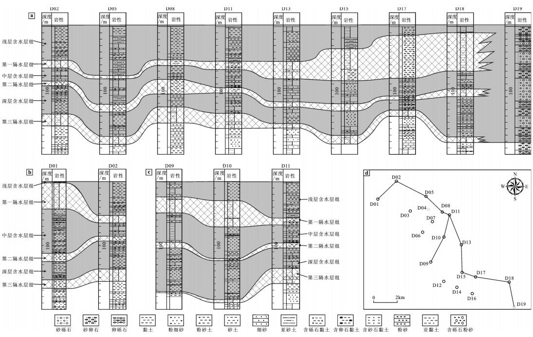
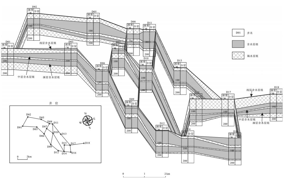
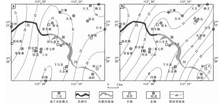
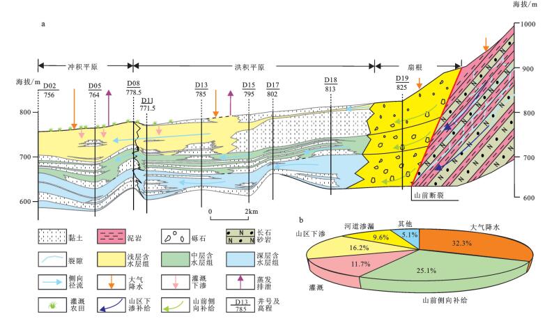
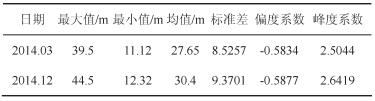
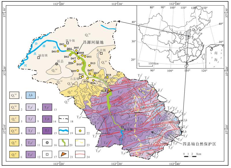
通过系统分析山西祁县昌源河中下游丘陵—平原地区沿河分布的19口钻井资料,查明了昌源河湿地中下游地区含水层的主要岩性,根据含/隔水层的埋深和发育特征将研究区第四系含水层划分了浅、中、深三个含水层组;并通过连井剖面和栅状图对比、总结了区内含水层的空间分布特征;同时,基于ArcGIS平台,采用Kriging插值法对地下水埋深进行了插值分析。结果表明昌源河流域含水层的主要岩石类型为第四系砂、砾石沉积物,在顺昌源河流向上浅部含水层为一楔状体,在横切河流方向上各含水层组厚度变化较大,这与研究区含水层组形成于冲/洪积扇沉积背景相符合。地下水埋深插值分析表明,昌源河流域中、下游平原区存在大面积的浅层地下水降落漏斗,这将会影响昌源河湿地公园及流域的生态水文过程。最后,在以上研究的基础上对昌源河流域地下水的补排关系进行了探讨,并建立了相应的补排模式。
Abstract:The data from 19 drill holes located in the hilly-plain region of the middle-lower reaches of the Changyuan River were systemically analyzed and, as a result, the predominant rock types of aquifers in the middle-lower reaches of the Changyuan River wetland were identified. Furthermore, based on the burial depth and development characteristics of aquifers and aquifuges, the authors divided the Quaternary aquifers in the study area into three aquifer sets, i.e., shallow, middle and deep aquifer sets. The features of spatial distribution of the aquifers in the study area were also summarized via correlation of cross sections and fence diagrams. In addition, the burial depths of groundwater tables were analyzed by using Kriging interpolation method. The results indicate that the predominant rock types of the aquifers are Quaternary sandy and gravel sediments. The profile of the shallow aquifer is like a wedged body in the downriver direction of the Changyuan River, but the thickness of the aquifer is not stable in the perpendicular direction of the river. This is in accordance with the sedimentary environment of the alluvial/fluvial fan. The results of interpolation analysis show that there are widely distributed precipitation funnels in the milled-lower reaches of the Changyuan River basin. Such a situation would impact the eco-hydrogeological process in the Changyuan River wetland park and the drainage basin. Finally, the authors discussed the recharge-discharge processes of the groundwater in the Changyuan River drainage basin and established a recharge-discharge model.
-
Key words:
- wetland /
- aquifer /
- groundwater /
- hydrogeology /
- Changyuan River
-

-
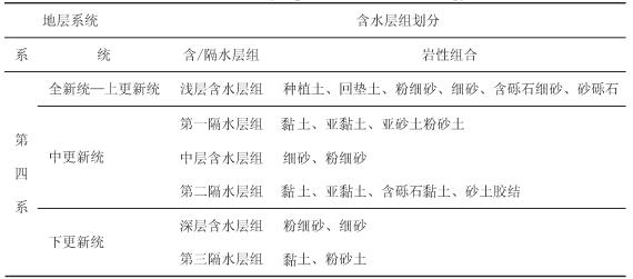
表 1 昌源河湿地第四系含水层组划分
Table 1. Division of the Quaternary aquifer sets in the Changyuan River wetland
 下载: 导出CSV
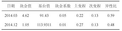
表 3 祁县2014年地下水埋深球状模型参数
Table 3. Parameters of the spherical models of groundwater burial depths in Qixian County
 下载: 导出CSV
-
Chow V T, Maidment D R, Mays L W.1988.Applied hydrology[M].New York:McGraw-Hill, Inc., 1-17.
Deng Wei, Hu Jinming.2003.Development of wetland hydrology research and key scientific issues[J].Wetland Science, 01:12-20(in Chinese with English abstract).
Fan Jingzhou.1991.The division and calibration of aquifers in thick geological units[J].Coal Geology of China, 03:55-56(in Chinese).
Fang Peixian.1996.Specialized hydrogeology[M].Beijing:Geological Publishing House (in Chinese).
Matheron G.1963.Principles of Geostatistics[J].Economic Geology, 58:1246-1266. doi: 10.2113/gsecongeo.58.8.1246
Ruan Benqing, Xu Fengran, Jiang Renfei.2008.Analysis on spatial and temporal variability of groundwater level based on spherical sampling model[J].Journal of Hydraulic Engineering, 2008, 05:573-579(in Chinese with English abstract). https://www.researchgate.net/publication/294314056_Analysis_on_spatial_and_temporal_variability_of_groundwater_level_based_on_spherical_sampling_model
Schot P P, Pieber S M.2012.Spatial and temporal variations in shallow wetland groundwater quality[J].Journal of Hydrology, 422-423:43-52. doi: 10.1016/j.jhydrol.2011.12.023
Shanxi Provincial Bureau of Geology and Mineral Resources.1989.Geological annals of Shanxi Province[M].Beijing:Geological Publishing House (in Chinese).
Shen Zhenrong, Zhang Yufang, Yang Shixiu.1992.Scientific Experiment and Research of Water Resources[M].Beijing:China Science and Technology Press, 1992:415-418(in Chinese).
Song Yang, Zhou Weibo, Ma Cong, Li Hui, Liu Boyang.2015.Analysis of spatial variability of groundwater depth in Xi'an downtown area[J].Yellow River, 08:56-59(in Chinese with English abstract).
Tang Guoan, Yang xin.2006.ArcGIS Geographic Information System Sspatial Analysis Experiment Course (Second Edition)[M].Beijing:Science Press, 419-420(in Chinese).
Topponnier P, Molnar P.1976.Slip line field theory and large-scale continental tectonics[J].Nature, 264:319-324. doi: 10.1038/264319a0
Wang Dachun.1995.Fundamentals of Hydrogeology[M].Beijing:Geological Publishing House (in Chinese).
Wang Lei, Zhang Guangxin.2007.Hydrochemical interaction between surface water and groundwater in Zhalong Wetland[J].Wetland Science, 5(2):166-173(in Chinese with English abstract).
Wang Yong.2006.Vulnerability assessment to Dongguan Town in Qixian ground water resources based on GIS[D].Taiyuan University of Technology.(in Chinese with English abstract).
Wang Zhongzhong, 2011.Liu Hua.Analysis on structures and hydrogeological characteristics of aquifers in the Southern Guangzhou City[J].Underground Water, 04:79-81(in Chinese with English abstract).
Wen Hong.2010.Talking about the present situation of water environment in Qixian County and the protection countermeasures[J].Sci-Tech Information Development&Economy, 20(8):124-126(in Chinese). http://www.doc88.com/p-2711294627431.html
Wu Guoqiang, Zhu Yanming, Wang Zhongping, Cao Aiguo, Wang Gang.2001.Tectonic characteristics of Fanwang exploration area in Jinzhong Fault depression[J].Journal of China University of Mining&Technology, 05:41-44(in Chinese with English abstract). http://en.cnki.com.cn/Article_en/CJFDTotal-ZGKD200105009.htm
Xing Jishan, Ye Zhiguang, Sun Zhenguo, Wu Hongwu, Chen Changwu, Li Jinhua, Song Hong.1991.Preliminary discussions on intraplate structural features and their evolution in Shanxi province[J].Shanxi Geology, 6(1):3-15(in Chinese with English abstract).
Xu Huashan, Zhao Tongqian, Meng Hongqi, Xu Zongxue, Ma Chaohong.2011.Relationship between groundwater level in Riparian Wetlands and water level in the river[J].Environmental Science, 32(2):362-367(in Chinese with English abstract). http://www.oalib.com/paper/1587051
Xu Yihe, Wei Xiaomei, Cai Mingke, Hu Guojie, Xu Wanlin.2011.Geostatistics-based study of spatial variability of groundwater level in Baoji urban area[J].Research of Soil and Water Conservation, 18(2):213-214(in Chinese with English abstract).
Zhang Renduo.2005.Spatial Variability Theory and Applications[M].Beijing:Science Press, (in Chinese).
Zhou Xuming.1988.The application of groundwater management model in the Qixian County, Shanxi Province[J].Hydrgeology and Engineering Geology, 2:30-34(in Chinese with English abstract).
邓伟, 胡金明.2003.湿地水文学研究进展及科学前沿问题[J].湿地科学, 01:12-20. doi: 10.3969/j.issn.1672-5948.2003.01.004
樊景洲.1991.厚地层单元含水层的划分和定厚[J].中国煤田地质, 03:55-56. http://www.wenkuxiazai.com/doc/9c948560f5335a8102d220c4.html
房佩贤.1996.专门水文地质学[M].北京:地质出版社.
阮本清, 许凤冉, 蒋任飞.2008.基于球状模型参数的地下水水位空间变异特性及其演化规律分析[J].水利学报, 05:573-579. doi: 10.3321/j.issn:0559-9350.2008.05.010
山西省地质矿产局.1989.山西省区域地质志[M].北京:地质出版社.
沈振荣, 张瑜芳, 杨诗秀.1992.水资源科学实验与研究[M].北京:中国科学技术出版社, 415-418.
宋扬, 周维博, 马聪, 李惠, 刘博洋.2015.西安主城区地下水埋深空间变异性分析[J].人民黄河, 08:56-59. http://www.cnki.com.cn/Article/CJFDTotal-RMHH201508017.htm
汤国安, 杨昕.2006.ArcGIS地理信息系统空间分析实验教程(第二版)[M].北京:科学出版社, 419-420.
王大纯.1995.水文地质学基础[M].北京:地质出版社.
王磊, 章光新.2007.扎龙湿地地表水与浅层地下水的水文化学联系研究[J].湿地科学, 5(2):166-173. http://www.wenkuxiazai.com/doc/822758e66f1aff00bed51e77.html
王勇. 2006. 基于GIS对祁县东观地下水资源脆弱性评价[D]. 太原理工大学.
http://cdmd.cnki.com.cn/Article/CDMD-10112-2006152967.htm 王忠忠, 刘华.2011.广州南部地区水文地质特征及含水层结构分析[J].地下水, 04:79-81. http://www.docin.com/p-706771984.html
温弘.2010.祁县水环境现状及保护对策[J].科技情报开发与经济, 20(8):124-126. http://www.cqvip.com/QK/97443X/201008/33470331.html
吴国强, 朱炎铭, 王仲平, 曹爱国, 王刚.2001.晋中断陷樊王普查区的构造特征研究[J].中国矿业大学学报, 05:41-44. http://www.cnki.com.cn/Article/CJFDTOTAL-XDDZ199102003.htm
邢集善, 叶志光, 孙振国, 吴洪武, 陈昌武, 李金花, 宋虹.1991.山西板内构造及其演化特征初探[J].山西地质, 6(1):3-15. http://www.cqvip.com/qk/93674X/199101/585570.html
徐华山, 赵同谦, 孟红旗, 徐宗学, 马朝红.2011.滨河湿地地下水水位变化及其与河水响应关系研究[J].环境科学, 32(2):362-367. http://www.oalib.com/paper/1587051
许义和, 魏晓妹, 蔡明科, 胡国杰, 徐万林.2011.基于地统计学的宝鸡市区地下水位空间变异特性研究[J].水土保持研究, 18(2):213-214. http://www.cqvip.com/QK/98303X/201101/36850933.html
张仁铎.2005.空间变异理论及应用[M].北京:科学出版社.
周旭明.1988.地下水管理模型在山西省祁县的应用[J].水文地质与工程地质, 2:30-34. http://kns.cnki.net/KCMS/detail/detail.aspx?filename=swdg198802009&dbname=CJFD&dbcode=CJFQ
-
图(5)
表(3)
计量
- 文章访问数: 2185
- PDF下载数: 1215
- 施引文献: 0