

-
摘要:
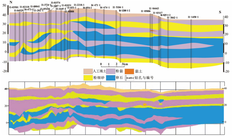
随着城市地下空间的开发利用,对三维地质结构的掌握成为科学合理开发利用地下空间的基本前提,三维地质模型的创建也得以迅速发展。三维地质结构模型可以直观展示地层空间分布形态,为地下空间资源的科学规划提供基础数据。本次工作首次完成了北京五环城区(750 km2)的三维地质结构模型创建。建模工作基于研究区广泛分布的数千工程钻孔,通过筛选、标准化钻孔数据,绘制相应标准化地层剖面(107条),创建了钻孔模型,以及北京五环城区地下50 m以浅三维地质结构模型,并完成精度验证。本次建模过程整理了大量工程钻孔数据,综合考虑了冲洪积扇发育区地层互层、相交、尖灭、透镜体等复杂的地质现象,具有代表性,可为类似地质建模工作提供借鉴。此外,北京城区三维地质结构模型直观展示了研究区浅部的地层分布与地层结构,为后续三维属性模型的创建提供了实体框架,亦为区内地下空间资源地质评价提供了数据支撑。
Abstract:The three-dimensional (3D) geological structure model has been the basic preconditions for the analysis of urban underground space, because it can directly display the spatial distribution and geological properties of superficial deposits and provide basic data for the scientific planning of the underground space resources. In this paper, the authors constructed for the very first time a 3D geological structure model (up to the depth of 50m from the surface) in Beijing City, based on almost a thousand boreholes, investigation reports, as well as 107 intersecting cross-sections arranged over Beijing City within the 5th Ring Road. The authors investigated the 3D modeling procedures in the study area, where an extremely complicated sedimentary environment is developed with various geological phenomena including intersecting stratigraphic interfaces, missing strata as well as discontinuous layers. The resulting 3D model could provide a basic framework and data support for further geological evaluation of underground space resources.
-
Key words:
- 3D geological modelling /
- superficial deposits /
- boreholes /
- cross-sections /
- lens
-

-
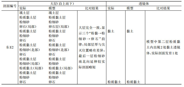
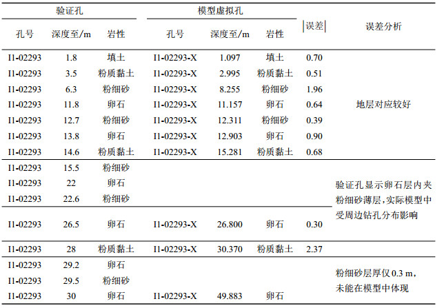
表 2 实际地质剖面与模型切片对比
Table 2. A comparison of detailed layers of borehole-based geological profiles and 3D model
 下载: 导出CSV
-
Akpokodje E G. 1987. The engineering-geological characteristics and classification of the major superficial soils of the Niger Delta[J]. Engineering Geology, 23:193-211. doi: 10.1016/0013-7952(87)90090-1
Bao Yigang, Liu Zhenfeng, Wang Shifa. 2001. A Centennial Study of Geology in Beijing:History and Latest Achievements of Basic Geological Research in Beijing Area[M]. Beijing:Geological Publishing House (in Chinese).
Beijing Geology Prospecting & Development Bureau, Beijing Institute of Geological Survey. 2008. Urban Geology of Beijing[M]. Beijng:China Land Press (in Chinese).
Bureau of Geology and Mineral Resources of Beijing Municipality. 1991. Regional Geology of Beijing Municipality[M]. Beijing:Geological Publishing House, 1-598 (in Chinese with English abstract).
Cai Xiangmin, Guo Gaoxuan, Luan Yingbo, Liang Yanan. 2009.Quaternary geological features of Beijing piedmont plain using 3-D structural method[J]. Acta Geologica Sinica, 83(7):1047-1057(in Chinese with English abstract). http://www.wanfangdata.com.cn/details/detail.do?_type=perio&id=dizhixb200907012
Cai Xiangmin, He Jing, Bai Lingyan, Liu Hong. 2010. The geology problem in development and utilization programming of underground space resources in Beijing[J]. Chinese Journal of Underground Space and Engineering, 6(6):1105-1111 (in Chinese with English abstract). http://www.wanfangdata.com.cn/details/detail.do?_type=perio&id=dxkj201006001
Cai Xiangmin, Zhang Lei, Guo Gaoxuan, You Shina, Fang Tongming, LV Jinbo, Liang Yanan. 2016. New Progress in the study of Quaternary geology in Beijing Plain[J]. Geology in China, 43, (3):1055-1066(in Chinese with English abstract). http://www.wanfangdata.com.cn/details/detail.do?_type=perio&id=zgdizhi201603027
Chen Guoxu, Wu Chonglong, Zhang Xialin, Tian Yiping, Liu Gang. 2010. Study on integration of 3D geological modeling and mineral resource exploration mapping[J]. Geology and Exploration, 46(3):542-456 (in Chinese with English abstract). http://d.old.wanfangdata.com.cn/Periodical/dzykt201003023
Dassargues A, Biver P, Monjoie A.1991. Geotechnical properties of the Quaternary sediments in Shanghai[J]. Engineering Geology, 31:71-90. doi: 10.1016/0013-7952(91)90058-S
Katherine R Royse. 2010. Combining numerical and cognitive 3D modelling approaches in order to determine the structure of the Chalk in the London Basin[J]. Computers & Geosciences, 36:500-511. https://www.sciencedirect.com/science/article/pii/S0098300409003252
He Huaijian, Bai Shiwei, Zhao Xinhua, Chen Jian. 2002. Discussion on strata partition in three dimension strata model[J]. Rock and Soil Mechanics, 23 (5):637-639 (in Chinese with English abstract). http://www.wanfangdata.com.cn/details/detail.do?_type=perio&id=ytlx200205024
Houlding S W. 1993.3D Geoscience Modeling:Computer Techniques for Geological Characterization[M]. London:Springer-Verlag:1-2.
Kaufmann O, Martin T. 2008.3D geological modeling from boreholes, cross-sections and geological maps, applaication over former natural gas storages in coal mines[J]. Computers & Geoscineces, 34(3):278-290.
Lai Jin, Han Nengrun, Jia Yunwu, Ji Yushan, Wang Guiwen, Pang Xiaojiao, He Zhibo, Wang Song. 2018. Detailed description of the sedimentary reservoir of a braided delta based on well logs[J]. Geology in China, 45(2):304-318(in Chinese with English abstract). http://d.old.wanfangdata.com.cn/Periodical/zgdizhi201802007
Li Qingyuan, Zhang Luoyi, Cao Daiyong, Dong Qianlin, Cui Yang, Chen Chunmei. 2016. Usage, status, problems, trends and suggestions of 3D geological modeling[J]. Geology and Exploration, 52(4):759-767(in Chinese with English abstract). http://www.wanfangdata.com.cn/details/detail.do?_type=perio&id=dzykt201604018
Li Xiaojun, Li Peinan, Zhu Hehua, Liu Jun. 2014. Geomodeling with integration of multi-source data by Bayesian Kriging in underground space[J]. Journal of Tongji University(Natural Science), 42(3):406-412 (in Chinese with English abstract). http://www.wanfangdata.com.cn/details/detail.do?_type=perio&id=tjdxxb201403013
Liangfeng Zhu, Chengjuan Zhang, Mingjiang Li. 2012. Building 3D solid models of sedimentary stratigraphic systems from borehole data:An automatic method and case studies[J]. Engineering Geology, 127:1-13. doi: 10.1016/j.enggeo.2011.12.001
Ma Zhen, Xie Hailan, Lin Liangjun, Hu Qiuyun, Qian Yong, Zhang Surong, Wang Guiling, Li Jianguo, Tan Chengxuan, Guo Haipeng, Zhang Fucun, Zhao Changrong, Liu Hongwei. 2017. The environmental geological conditions of Land resources in the Beijing-Tianjin-Hebei region[J]. Geology in China, 44(5):857-873(in Chinese with English abstract). http://www.wanfangdata.com.cn/details/detail.do?_type=perio&id=zgdizhi201705004
Ming Jing, Pan Mao, Qu Honggang, Wu Zixing. 2008. Threedimensional geological multi-body modeling from netlike crosssections with topology[J]. Chinese Journal of Geotechnical Engineering, 30(9):1376-1382 (in Chinese with English abstract). http://en.cnki.com.cn/Article_en/CJFDTOTAL-YTGC200809023.htm
Ming Jing, Xiang Zejun. 2015. Research and application on the integrated management platform of geological information for mountainous city[J]. Urban Geotechnical Investigation & Surveying, (5):147-153 (in Chinese with English abstract). http://www.wanfangdata.com.cn/details/detail.do?_type=perio&id=cskc201505044
Pan Mao, Fang Yu, Qu Honggang. 2007. Discussion on several foundational issues in three-dimensional geological modeling[J]. Geography and Geo-Information Science, 23(3):1-5 (in Chinese with English abstract). http://www.wanfangdata.com.cn/details/detail.do?_type=perio&id=dlxygtyj200703001
Sun Li, Xiao Keyan, Tang Juxing, Zou Wei, Li Nan, Sun Yan. 2011.3-D geologic modeling of the Jiama Cu deposit based on Minexplorer System[J]. Journal of Chengdu University of Technology (Science & Technology Edition), 38(3):291-297(in Chinese with English abstract). http://www.wanfangdata.com.cn/details/detail.do?_type=perio&id=cdlgxyxb201103008
Tonini A, Guastaldi E, Massa G, Conti P. 2008.3D geo-mapping based on surface data for preliminary study of underground works:A case study in Val Topina (Central Italy)[J]. Engineering Geology, 99:61-69. doi: 10.1016/j.enggeo.2008.02.010
Turner A K. 2006. Challenges and trends for geological modelling and visualization[J]. Bulletin of Engineering Geology and the Environment, 65 (2):109-127. doi: 10.1007/s10064-005-0015-0
Wellmann J F, Horowitz F G, Schill E, Regenauer-Lieb K. 2010.Towards incorporating uncertainty of structural data in 3D geological inversion[J]. Tectonophysics, 490 (3/4):141-151. http://www.wanfangdata.com.cn/details/detail.do?_type=perio&id=42d99563d8176978d9218025f7051176
Wu Qiang, Xu Hua, Zhou Xukai. 2005. An effective method for 3D geological modeling with multi-source data integration[J]. Computers & Geoscineces, 31(1):35-43. http://d.old.wanfangdata.com.cn/NSTLQK/10.1016-j.sna.2011.06.025/
Xiong Shengqing, Yang Hai, Ding Yanyun, Li Zhankui. 2018.Subdivision of tectonic units in China based on aeromagnetic data[J]. Geology in China, 45(4):658-680(in Chinese with English abstract). http://d.old.wanfangdata.com.cn/Periodical/zgdizhi201804003
Yu Can, Li Feng, Zeng Qingtian, Xiao Shuan, Zhang Dabing. 2016. A study on Cu-grade distribution of the Tongchang copper deposit in Yimen based on DIMINE Software[J]. Geology and Exploration, 52(2):376-384 (in Chinese with English abstract). http://d.old.wanfangdata.com.cn/Periodical/dzykt201602021
Zhang Lei, He Jing, Bai Lingyan, Cai Xiang-min, Wang Ji-min, Yang Tian-shui. 2016. The response relationship between the variation characteristics of deposition rate of Quaternary depression basin on the northern margin of Beijing depression and the activity of Shunyi fault[J]. Geology in China, 43, (2):511-519(in Chinese with English abstract). http://www.wanfangdata.com.cn/details/detail.do?_type=perio&id=zgdizhi201602012
Zhang Yangyang, Zhou Wanpeng, Wu Zhichun, Guo Fusheng, Zheng Xiang. 2013. The development status of 3D geological modeling technology and modeling instances[J]. Journal of East China Institute of Technology (Social Science), 32(3):403-409 (in Chinese with English abstract). http://www.wanfangdata.com.cn/details/detail.do?_type=perio&id=fuzszxb201303040
Zhang Yuan, Liu Yin, Xu Miaojuan, Sun Ying, Zheng Feifei, Song Guoxi. 2015. Research and practice of Beijing 3D geological modeling[J]. Geotechnical Investigation & Surveying, 43(6):60-65(in Chinese with English abstract). http://d.old.wanfangdata.com.cn/Periodical/gckc201506013
Zhu L, Zhang C J, Li M J. 2012. Building 3D solid models of sedimentary stratigraphic systems from borehole data:An automatic method and case studies[J]. Engineering Geology, 127:1-13. doi: 10.1016/j.enggeo.2011.12.001
Zhu Liangfeng, Wu Xincai, Liu Xiuguo, Shang Jianga. 2004. Reconstruction of 3D strata model based on borehole data[J]. Geography and Geo-information Science, 20(3):26-30 (in Chinese with English abstract). http://en.cnki.com.cn/Article_en/CJFDTotal-DLGT200403006.htm
鲍亦冈, 刘振锋, 王世发, 等. 2001.北京地质百年研究:北京地区基础地质研究的历史与最新成果[M].北京:地质出版社.
北京市地质矿产局. 1991.北京市区域地质志[M].北京:地质出版社, 1-598.
北京市地质矿产勘查开发局, 北京市地质调查研究院. 2008.北京城市地质[M].北京:中国大地出版社.
蔡向民, 郭高轩, 栾英波, 梁亚楠. 2009.北京山前平原区第四系三维结构调查方法研究及实践[J].地质学报, 83 (7):1047-1057. doi: 10.3321/j.issn:0001-5717.2009.07.012
蔡向民, 何静, 白凌燕, 刘鸿. 2010.北京市地下空间资源开发利用规划的地质问题[J].地下空间与工程学报, 6(6):1105-1111. http://d.old.wanfangdata.com.cn/Periodical/dxkj201006001
蔡向民, 张磊, 郭高轩, 尤世娜, 方同明, 吕金波, 梁亚楠.2016.北京平原地区第四纪地质研究新进展[J].中国地质, 43(3):1055-1066 http://geochina.cgs.gov.cn/geochina/ch/reader/view_abstract.aspx?file_no=20160327&flag=1
陈国旭, 吴冲龙, 张夏林, 田宜平, 刘刚. 2010.三维地质建模与地矿勘查图件编制一体化方法研究[J].地质与勘探, 46 (3):542-456. http://d.old.wanfangdata.com.cn/Periodical/dzykt201003023
贺怀建, 白世伟, 赵新华, 陈健. 2002.三维地层模型中地层划分的探讨[J].岩土力学, 23(5):637-639. doi: 10.3969/j.issn.1000-7598.2002.05.024
赖锦, 韩能润, 贾云武, 季玉山, 王贵文, 庞小娇, 贺智博, 王松. 2018.基于测井资料的辫状河三角洲沉积储层精细描述[J].中国地质, 45(2):304-318. http://geochina.cgs.gov.cn/geochina/ch/reader/view_abstract.aspx?file_no=20180207&flag=1
李青元, 张洛宜, 曹代勇, 董前林, 崔扬, 陈春梅. 2016.三维地质建模的用途、现状、问题、趋势与建议[J].地质与勘探, 52(4):759-767. http://d.old.wanfangdata.com.cn/Periodical/dzykt201604018
李晓军, 李培楠, 朱合华, 等. 2014.基于贝叶斯克里金的地下空间多源数据建模[J].同济大学学报(自然科学版), 42(3):406-412. doi: 10.3969/j.issn.0253-374x.2014.03.013
马震, 谢海澜, 林良俊, 胡秋韵, 钱永, 张素荣, 王贵玲, 李建国, 谭成轩, 郭海朋, 张福存, 赵长荣, 刘宏伟. 2017.京津冀地区国土资源环境地质条件分析[J].中国地质, 44(5):857-873. http://geochina.cgs.gov.cn/geochina/ch/reader/view_abstract.aspx?file_no=20170503&flag=1
明镜, 潘懋, 屈红刚, 吴自兴. 2008.基于网状含拓扑剖面的三维地质多体建模[J].岩土工程学报, 30(9):1376-1382. doi: 10.3321/j.issn:1000-4548.2008.09.020
明镜, 向泽君. 2015.山地城市地质信息集成管理平台研究与应用[J].城市勘测, (5):147-153. doi: 10.3969/j.issn.1672-8262.2015.05.044
潘懋, 方裕, 屈红刚. 2007.三维地质建模若干基本问题探讨[J].地理与地理信息科学, 23(3):1-5. doi: 10.3969/j.issn.1672-0504.2007.03.001
孙莉, 肖克炎, 唐菊兴, 伟, 李楠, 孙艳. 2011.基于Minexplorer探矿者软件的甲玛铜矿三维地质体建模[J].成都理工大学学报(自然科学版), 38(3):291-297. doi: 10.3969/j.issn.1671-9727.2011.03.008
熊盛青, 杨海, 丁燕云, 李占奎. 2018.中国航磁大地构造单元划分[J].中国地质, 45(4):658-680. http://geochina.cgs.gov.cn/geochina/ch/reader/view_abstract.aspx?file_no=20180402&flag=1
余璨, 李峰, 曾庆田, 肖术安, 张达兵. 2016.基于DIMINE软件的易门铜厂矿床Cu品位分布规律研究[J].地质与勘探, 52(2):376-384. http://d.old.wanfangdata.com.cn/Periodical/dzykt201602021
张磊, 何静, 白凌燕, 蔡向民, 王继明, 杨天水.2016.北京凹陷北缘第四纪凹陷盆地沉积速率变化特征与顺义断裂活动性的响应关系[J].中国地质, 43, (2):511-519. doi: 10.3969/j.issn.1000-3657.2016.02.012 http://geochina.cgs.gov.cn/geochina/ch/reader/view_abstract.aspx?file_no=20160212&flag=1
张洋洋, 周万蓬, 吴志春. 2013.三维地质建模技术发展现状及建模实例[J].东华理工大学学报(社会科学版), 32(3):403-409. http://d.old.wanfangdata.com.cn/Periodical/fuzszxb201303040
张院, 刘殷, 许苗娟, 孙颖, 郑菲菲, 宋国玺. 2015.北京三维地质建模研究与实践[J].工程勘察, 43 (6):60-65. http://d.old.wanfangdata.com.cn/Periodical/gckc201506013
朱良峰, 吴信才, 刘修国, 尚建嘎. 2004.基于钻孔数据的三维地层模型的构建[J].地理与地理信息科学, 20(3):26-30. doi: 10.3969/j.issn.1672-0504.2004.03.006
-


图(11)
表(2)
计量
- 文章访问数: 2670
- PDF下载数: 930
- 施引文献: 0