Exploration of Mineral Water Resources in City Clusters Along the Middle Reaches of the Yangtze and Discoveries ― A Case Study of the Dataset of the Hydrogeological Survey in the 1∶50 000 Tingsiqiao Map-sheet, Xianning City
-
摘要:
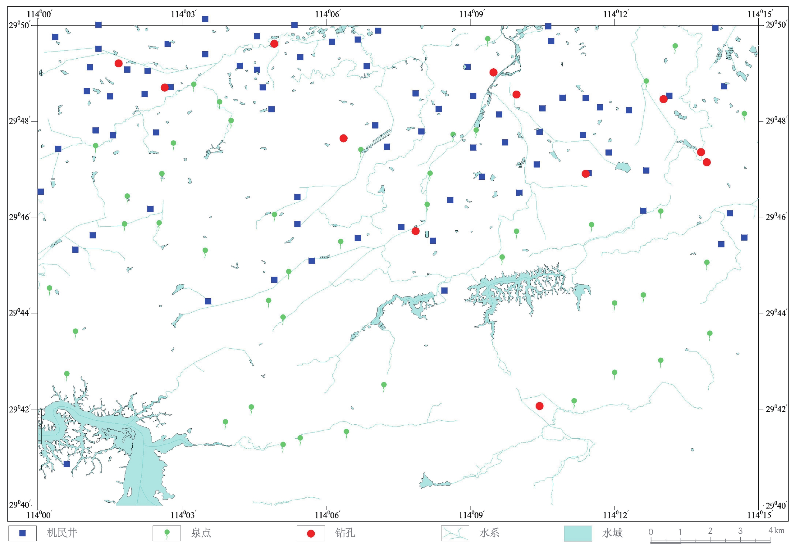
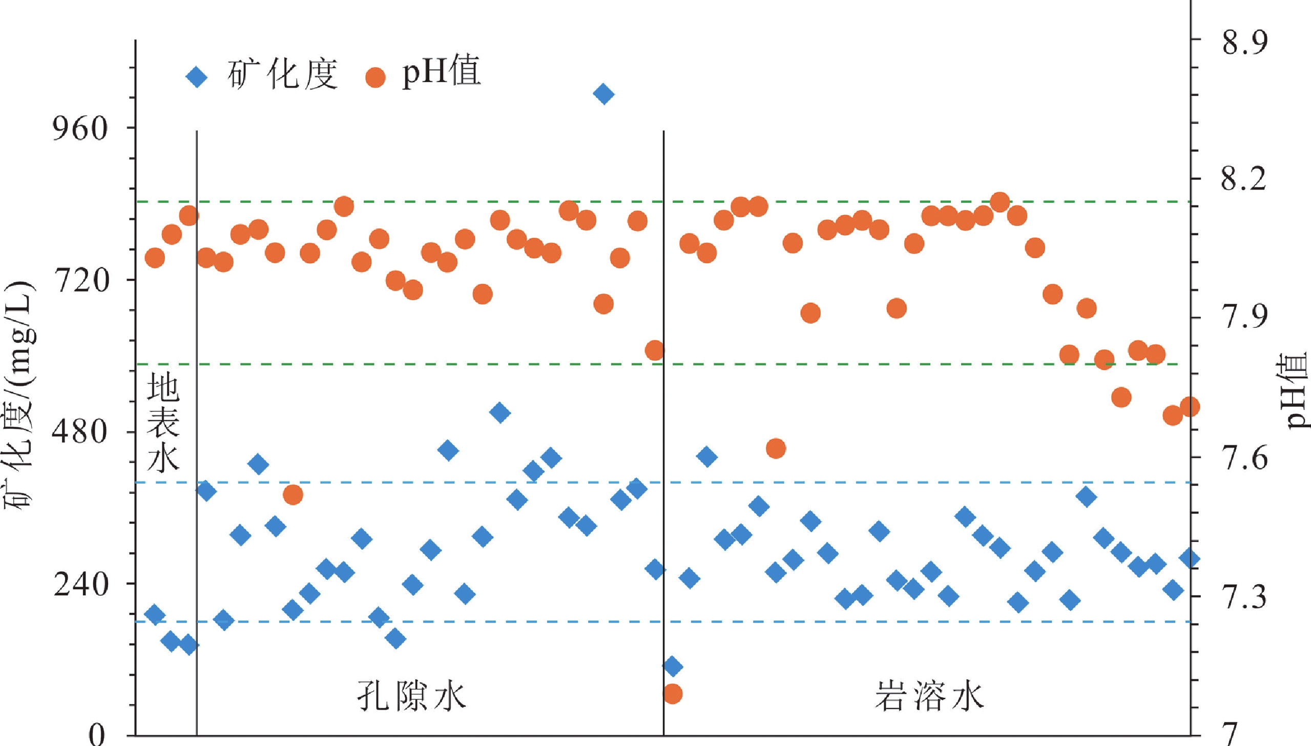
长江中游城市群承东启西、连接南北,在我国经济均衡发展、和谐发展中占有重要地位,咸宁地区矿泉水资源的发现,将助力绿色经济发展。咸宁汀泗桥幅数据依托中国地质调查局“武汉都市圈京广高铁沿线汀泗桥幅地质环境综合调查”项目,在充分收集地质、遥感、物探及水文地质等资料基础上,开展汀泗桥幅1∶50 000水文地质调查。本数据集包含钻孔基本信息(12个钻孔)、钻孔地层描述信息(12个钻孔)、机民井点调查结果(77个机民井)、泉点调查结果(46个泉点)、地下水动态监测信息(2处)、无机水样测试结果(61件)和有机水样测试结果(9件),数据量约为4.77 MB。数据集充分反映了1∶50 000水文地质调查中典型水文地质现象、灰岩地层的岩溶发育特点及岩溶地下水的水化学特征。通过水化学分析,在咸宁市汀泗桥镇白羊畈−赤壁官塘驿镇大贵畈−中伙铺镇一线发现富锶型饮用天然矿泉水,赤壁中伙铺琅桥一带为富锶、富锌复合型饮用天然矿泉水,对该区的矿泉水资源勘查具有重要参考意义。实施探采结合井,服务地方用水需求。
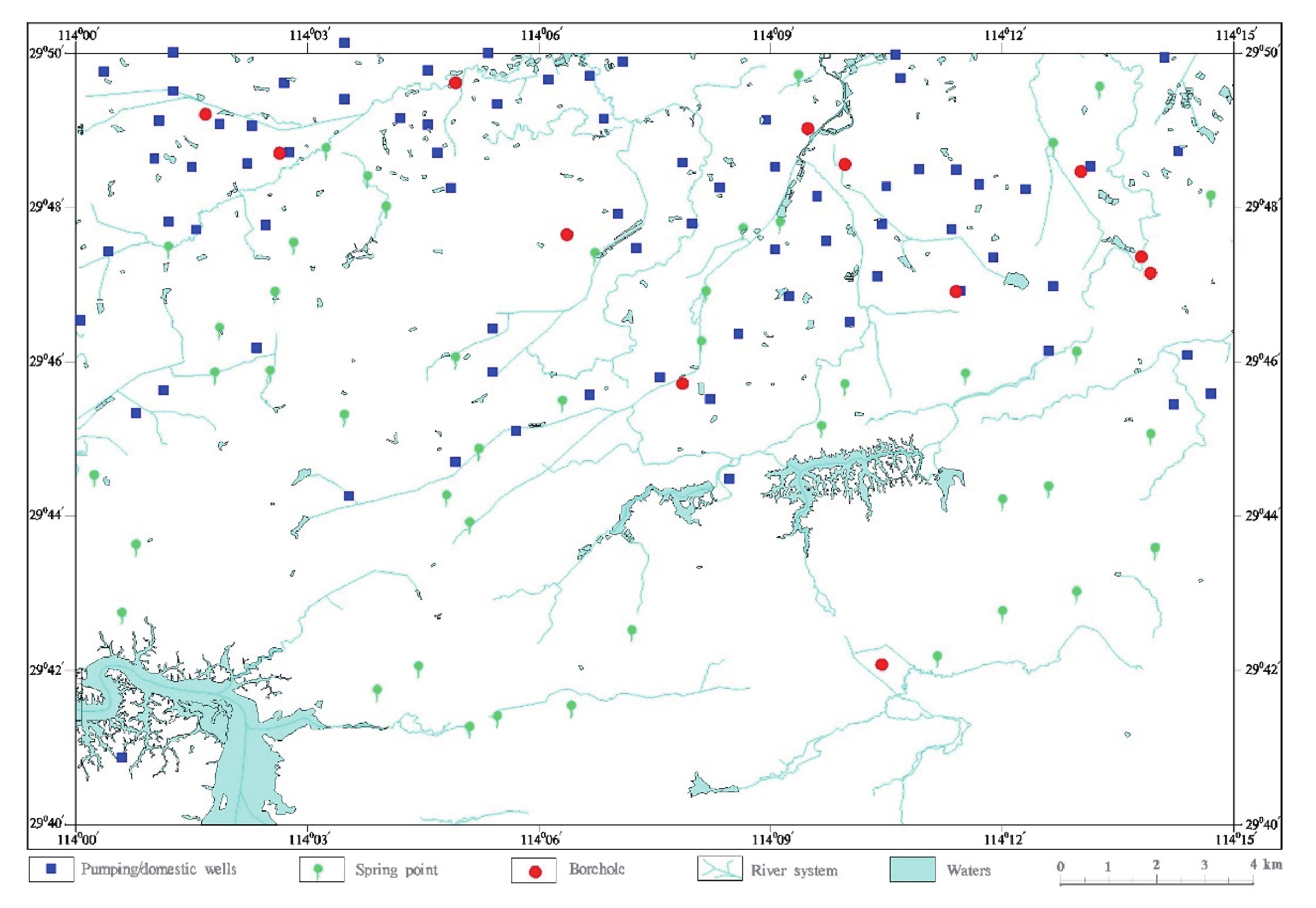
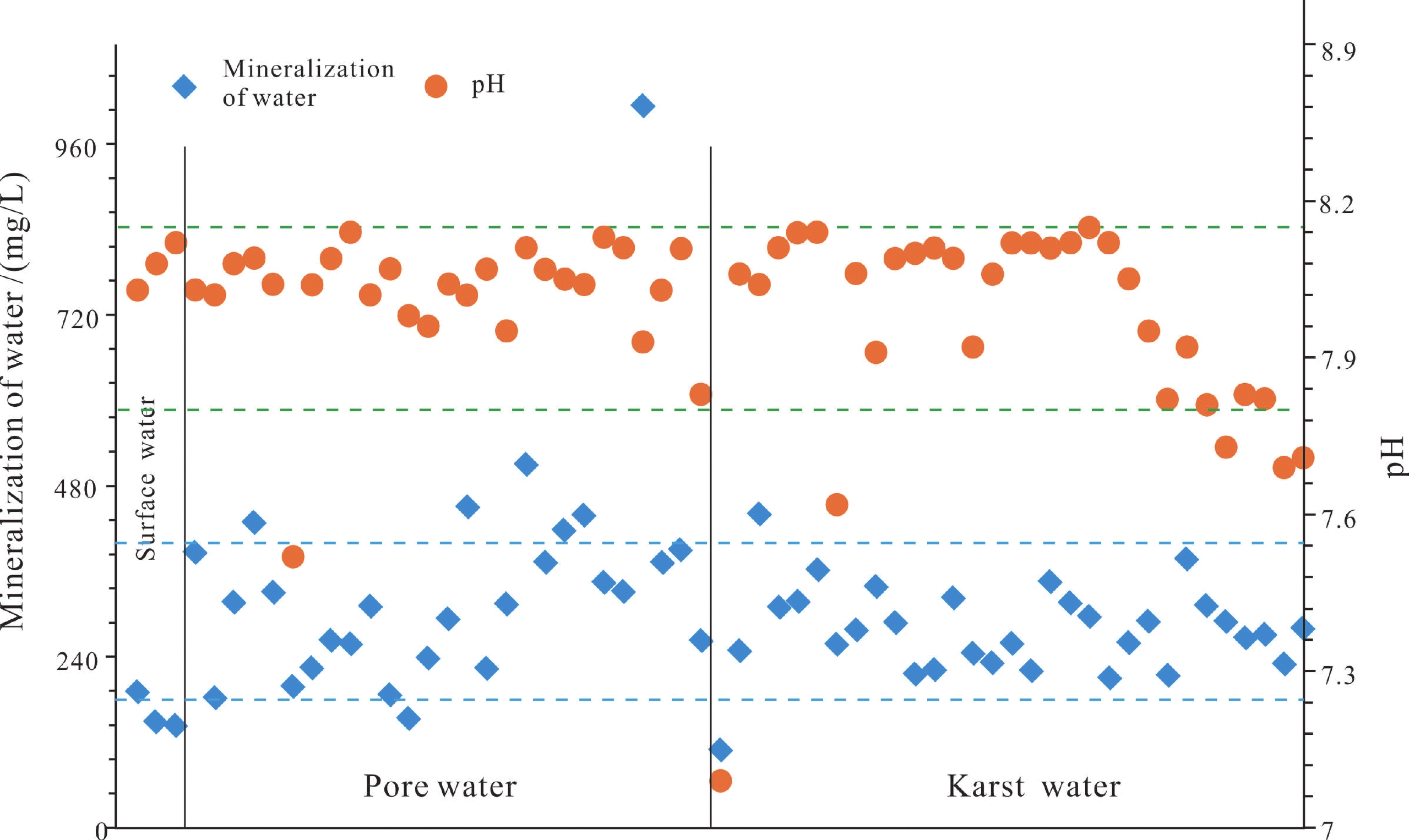
Abstract:The city clusters along the middle reaches of the Yangtze River, which connect the western parts with the eastern parts and the southern parts with the northern parts of China, play an important role in the balanced and harmonious development of the economy in China. The discovery of mineral water resources in Xianning City will contribute to the development of a green economy. Relying on the project initiated by China Geological Survey with the title Comprehensive Geological Environmental Survey of the Tingsiqiao Map-sheet in the Wuhan Metropolitan Area Along the Beijing-Guangzhou High-speed Railway, the dataset of the Tingsiqiao Map-sheet (also referred to as the Dataset) was developed through the hydrogeological survey in the Tingsiqiao Map-sheet, on a scale of 1∶50 000, as well as a full collection of existing geological survey data, remote sensing, geophysical prospecting and a hydrogeological survey. It consists of basic information on boreholes (12 boreholes), descriptions of strata revealed by boreholes (12 boreholes), results from the survey points of pumping/domestic wells (77 pumping/domestic wells), spring points survey results (46 spring points), dynamic monitoring information of groundwater (2 places) and test results from inorganic water samples (61 samples) and organic water samples (9 samples); with a data size of about 4.77 MB. From this dataset, the typical hydrogeological phenomena, the development features of karst in limestone strata and the hydrochemical features of karst groundwater obtained from the hydrogeological survey were fully reflected. According to hydrochemical analysis, Sr-rich potable natural mineral water is discovered along Baiyangfan, Tingsiqiao Town, Xianning City – Daguifan, Guantangyi Town, Chibi City – Zhonghuopu Town and Chibi City. Sr-rich and Zn-rich composite potable natural mineral water is also discovered in the Langqiao area, Zhonghuopu Town and Chibi City, providing important references for the exploration of mineral water resources in the area. Exploration-production wells were drilled with an aim to meet the local demand for water.
-

-
表 1 数据库(集)元数据简表
条目 描述 数据库(集)名称 1∶50 000咸宁市汀泗桥幅水文地质调查数据集 数据库(集)作者 杨艳林,中国地质调查局武汉地质调查中心
陈立德,中国地质调查局武汉地质调查中心
邵长生,中国地质调查局武汉地质调查中心
路韬,中国地质调查局武汉地质调查中心
张傲,中国地质调查局武汉地质调查中心数据时间范围 2016年1月—2016年12月 地理区域 咸宁市咸安区汀泗桥镇,面积约450 km2;地理坐标:东经114°00′~114°15′,北纬29°40′~29°50′ 数据格式 *.xls 数据量 4.77 MB 数据服务系统网址 http://dcc.cgs.gov.cn 基金项目 中国地质调查局地质调查项目(DD20160248)资助 语种 中文 数据库(集)组成 钻孔基础数据.xls、钻孔地层描述信息.xls、机民井点调查表.xls、泉点调查表.xls、地下水位动态监测表.xls、有机水样测试结果.xls、无机水样测试结果.xls 表 2 钻孔基本信息
序号 数据项名称 单位 数据类型 实例 1 钻孔编号 字符串 SZK01 2 X 浮点型 20230908 3 Y 浮点型 3302058 4 地理位置 字符串 湖北省咸宁市汀泗桥镇彭碑村六组 5 地面高程 m 浮点型 38.00 6 开孔孔径 m 浮点型 130.00 7 孔径 字符串 0~11.8 m,r=80 mm;11.8~39 m,r=73 mm;39.0~101.0 m,r=61 mm 8 终孔深度 m 浮点型 101.00 9 初见水位 m 浮点型 1.00 10 静水位埋深 m 浮点型 1.00 11 滤水管段 字符串 13.00~101.00 m 12 主要含水层段 字符串 20.0~21.3 m;42.0~44.6 m;65.0~67.4 m 13 极大降深−涌水量 字符串 7.90 ~118.90 m3/d 14 取样情况 字符串 水样:有机样与无机样 15 备注 字符串 未见溶洞 表 3 钻孔地层描述
序号 数据项名称 单位 数据类型 实例 1 钻孔编号 字符串 SZK01 2 层号 整数型 1 3 地层时代 字符串 Qh 4 层底高程 m 浮点型 36 5 层底埋深 m 浮点型 2 6 层厚 m 浮点型 2 7 地层岩性描述 字符串 红褐色—灰褐色耕植土,岩芯呈短柱状,切面较粗糙,略潮湿,局部可见少量植物根系 表 4 机民井点普查调查表
序号 数据项名称 单位 数据类型 实例 1 野外编号 字符串 D533 2 X 浮点型 20218231 3 Y 浮点型 3298611 4 地理位置 字符串 湖北省赤壁市官塘驿镇官塘村七组 5 井口高程 m 浮点型 49.1 6 井口直径 mm 浮点型 650.0 7 水位埋深 m 浮点型 1.64 8 井深 m 浮点型 12 9 井壁结构 字符串 砖彻 10 取水层位 字符串 孔隙潜水 11 含水层岩性 字符串 砂土 12 水温 ℃ 浮点型 19.73 13 开采量 m3/h 浮点型 0.008 3 14 pH 浮点型 6.96 15 味 字符串 无 16 气温 ℃ 浮点型 30 17 气味 字符串 无 18 溶解氧 mg/L 浮点型 6.21 19 电导率 μs/cm 浮点型 291 20 氧化还原电位 mV 浮点型 356 21 调查时间 日期型 2016-8-15 表 5 泉点普查调查表
序号 数据项名称 单位 数据类型 实例 1 野外编号 字符串 D531 2 X 浮点型 20218487 3 Y 浮点型 3297583 4 地理位置 字符串 赤壁市官塘驿镇官塘村十组 5 泉水类型 字符串 下降泉 6 地面高程 m 浮点型 62.0 7 含水层岩性 字符串 T1d4白云质灰岩 8 泉水成因 图片 
9 主要用途 字符串 生活、灌溉用水 10 气温 ℃ 浮点型 29.0 11 流量测定方法 字符串 流速仪 12 泉水流量 L/s 浮点型 2.3 13 泉水温度 ℃ 浮点型 19.64 14 色度 字符串 无 15 味 字符串 无 16 气味 字符串 无 17 透明度 字符串 清澈透明 18 pH 浮点型 7.44 19 氧化还原电位 mV 浮点型 339 20 溶解氧 mg/L 浮点型 6.63 21 电导率 μs/cm 浮点型 995.4 22 调查时间 日期型 2016-8-15 Table 1. Metadata Table of the Database (Dataset)
Items Description Database (dataset) name Dataset of Hydrogeological Survey, on a Scale of 1∶50 000, in Tingsiqiao Map Sheet, Xianning City Database (dataset) authors Yang Yanlin, Wuhan Center, China Geological Survey
Chen Lide, Wuhan Center, China Geological Survey
Shao Changsheng, Wuhan Center, China Geological Survey
Lu Tao, Wuhan Center, China Geological Survey
Zhang Ao, Wuhan Center, China Geological SurveyData acquisition time January – December in 2016 Geographical area Tingsiqiao Town, Xian’an District, Xianning City, covering an area of about 450 km2; geographical coordinates: E 114°00′–114°15′, N 29°40′ –29°50′ Data format *.xls Data size 4.77 MB Data service system URL http://dcc.cgs.gov.cn Fund project A geological survey project initiated by China Geological Survey (DD20160248) Language Chinese Database (dataset) composition Basic data of boreholes.xls, description of strata revealed by boreholes.xls, survey points of pumping/domestic wells.xls, survey points of springs.xls, dynamic monitoring information of groundwater level.xls, test results from organic water samples.xls and test results from inorganic water samples.xls Table 2. Basic Data of Boreholes
No. Name of data item Unit Data type Example 1 No. string SZK01 2 X coordinate float 20230908 3 Y coordinate float 3302058 4 Geographical location string Group 6, Pengbei Village, Tingsiqiao Town, Xianning City, Hubei Province 5 Ground elevation m float 38.00 6 Borehole head diameter m float 130.00 7 Radius string 0–11.8 m, r=80 mm; 11.8–39 m, r=73 mm; 39.0–101.0 m, r=61 mm 8 Final depth m float 101.00 9 Initial water level m float 1.00 10 Burial depth of static water level m float 1.00 11 Screen section string 13.00–101.00 m 12 Main aquifer segment string 20.0–21.3 m; 42.0–44.6 m; 65.0–67.4 m 13 Max. drawdown – water yield string 7.90 –118.90 m3/d 14 Sampling information string Water sample: organic samples and inorganic samples 15 Remarks string No karst caves discovered Table 3. Description of Strata Revealed by Boreholes
No. Name of data item Unit Data type Example 1 Borehole no. string SZK01 2 Stratum no. int 1 3 Stratum age string Qh 4 Elevation of stratum bottom m float 36 5 Depth of stratum bottom m float 2 6 Stratum thickness m float 2 7 Description of stratum lithology string Rufous – dust-color arable soil, short-column-shaped core, rough section, slightly humid, a small amount of plant root system visible locally Table 4. Reconnaissance Survey of Pumping (Domestic) Wells
No. Name of data item Unit Data type Example 1 Field No. string D533 2 X coordinate float 20218231 3 Y coordinate float 3298611 4 Geographical location string Group 7, Guantang Village, Guantangyi Town, Chibi City, Hubei Province 5 Wellhead elevation m float 49.1 6 Wellhead diameter mm float 650.0 7 Burial depth of water level m float 1.64 8 Well depth m float 12 9 Well wall structure string Bricked 10 Water intake horizon string Pore phreatic water 11 Lithology of aquifer string Sandy soil 12 Water temperature ℃ float 19.73 13 Allowable yield m3/h float 0.0083 14 pH value float 6.96 15 Taste string No 16 Air temperature ℃ float 30 17 Odor string No 18 Dissolved oxygen mg/L float 6.21 19 EC µs/cm float 291 20 Eh mV float 356 21 Survey date Date 15-8-2016 Table 5. Reconnaissance Survey of Springs
No. Name of data item Unit Data type Example 1 Field No. string D531 2 X coordinate float 20218487 3 Y coordinate float 3297583 4 Geographical location string Group 10, Guantang Village, Guantangyi Town, Chibi City 5 Spring type string Gravity spring 6 Ground elevation m float 62.0 7 Lithology of aquifer string T1d4dolomitic limestone 8 Origin of spring Image 
9 Main purpose string Living and irrigation 10 Air temperature ℃ float 29.0 11 Method of measuring water flow string Flowmeter 12 Water flow L/s float 2.3 13 Water temperature ℃ float 19.64 14 Chroma string No 15 Taste string No 16 Odor string No 17 Transparency string Clear and transparent 18 pH value float 7.44 19 Eh mV float 339 20 Dissolved oxygen mg/L float 6.63 21 EC µs/cm float 995.4 22 Survey date Date 15-8-2016 -
[1] 环境保护部. 2009. 水质采样 样品的保存和管理技术规定: HJ 493−2009 [S]. 北京: 中国环境科学出出版社.
[2] 环境保护部.2009. 水质采样技术指导: HJ 494−2009 [S]. 北京: 中国环境科学出版社.
[3] 姜月华, 林良俊, 陈立德, 倪化勇, 葛伟亚, 成杭新, 翟刚毅, 王贵玲, 班宜忠, 李媛, 雷明堂, 谭成轩, 苏晶文, 周权平, 张泰丽, 李云, 刘红樱, 彭柯, 王寒梅. 2017. 资源环境条件与重大地质问题[J]. 中国地质, 44(6): 1045−1061. http://d.old.wanfangdata.com.cn/Periodical/zgdizhi201706002
[4] 杨艳林, 邵长生, 靖晶. 2018. 系统聚类法在划分岩溶地下水化学类型中的应用[J]. 物探与化探, 42(04): 738−744. http://d.old.wanfangdata.com.cn/Periodical/wtyht201804014
[5] 中华人民共和国地质矿产部. 1994. 地下水动态监测规程: DZ/T0133−1994 [S]. 北京: 中国标准出版社.
[6] 中华人民共和国国家发展和改革委员会. 2005. 钻孔抽水试验规程: DL/T 5213−2005 [S]. 北京: 中国电力出版社.
[7] 中华人民共和国国土资源部. 2006. 地质矿产实验室测试质量管理规范: DZ/T 0130−2006 [S]. 北京: 中国标准出版社.
[8] 中华人民共和国国土资源部. 2014. 水文水井地质钻探规程: DZT 0148−2014 [S].北京: 中国标准出版社.
[9] 中华人民共和国国土资源部. 2014. 地下水监测井建设规范: DZ/T 0270−2014 [S]. 北京: 中国标准出版社.
[10] 中华人民共和国国土资源部. 2015. 水文地质调查规范: DZT 0282−2015(1∶50 000) [S]. 北京: 地质出版社.
[11] 中华人民共和国卫生部. 2006. 生活饮用水标准检验方法水样的采集和保存: GB/T 5750.2−2006 [S]. 北京: 中国标准出版社.
[1] Jiang Yuehua, Lin Liangjun, Chen Lide, Ni Huayong, GeWeiya, Cheng Hangxin, Zhai Gangyi, Wang Guiling, Ban Yizhong, Li Yuan, Lei Mingtang, Tan Chengxuan, Su Jingwen, Zhou Quanping, Zhang Taili, Li Yun, Liu Hongying, Peng Ke, Wang Hanmei. 2017. Research on conditions of resources and environment and major geological problems in the Yangtze River Economic Zone[J]. Geology in China, 44(6): 1045−1061 (in Chinese with English abstract). http://www.wanfangdata.com.cn/details/detail.do?_type=perio&id=zgdizhi201706002
[2] Ministry of Environmental Protection of the People’s Republic of China. 2009. Water quality sampling-technical regulation of the preservation and handling of samples: HJ 493−2009[S]. Beijing: China Environmental Press (in Chinese).
[3] Ministry of Environmental Protection of the People’s Republic of China. 2009. Water quality-Guidance on sampling techniques: HJ 494−2009[S]. Beijing: China Environmental Press (in Chinese).
[4] Ministry of Geology and Mineral Resources of the People’s Republic of China.1994. Code for dynamic monitoring of groundwater: DZ/T 0133-1994[S]. Beijing: Standards Press of China (in Chinese).
[5] National Development and Reform Commission of the People’s Republic of China. 2005. Code of pumping test in borehole for hydropower and water conservancy engineering: DL/T 5213-2005[S]. Beijing: China Electric Power Press (in Chinese).
[6] Ministry of Land and Resources of the People’s Republic of China. 2006. The specification of testing quality management for geological laboratories: DZ/T 0130−2006[S]. Beijing: Standards Press of China (in Chinese).
[7] Ministry of Land and Resources of the People’s Republic of China. 2014. The specification for hydrogeological well drilling: DZ/T 0148−2014[S]. Beijing: Standards Press of China (in Chinese).
[8] Ministry of Land and Resources of the People’s Republic of China. 2014. Regulation of groundwater monitoring well construction: DZ/T 0270-2014[S]. Beijing: Standards Press of China (in Chinese).
[9] Ministry of Land and Resources of the People’s Republic of China.2015. Specification for hydrogeological survey(1∶50 000): DZ/T 0282−2015[S]. Beijing: Geological Publishing House (in Chinese).
[10] Ministry of Health of the People’s Republic of China. 2006. Standard examination methods for drinking water-Collection and preservation of water samples: GB/T 5750.2−2006[S]. Beijing: Standards Press of China (in Chinese).
[11] Yang Yanlin, Shao Changsheng, Jing Jing. 2018. The application of systematic clustering method to the classification of chemical types of karst groundwater[J]. Geophysical and Geochemical Exploration, 42(04): 738−744 (in Chinese with English abstract). http://d.old.wanfangdata.com.cn/Periodical/wtyht201804014
-


 下载:
下载:


